Related Research Articles
Earthquake prediction is a branch of the science of seismology concerned with the specification of the time, location, and magnitude of future earthquakes within stated limits, and particularly "the determination of parameters for the next strong earthquake to occur in a region". Earthquake prediction is sometimes distinguished from earthquake forecasting, which can be defined as the probabilistic assessment of general earthquake hazard, including the frequency and magnitude of damaging earthquakes in a given area over years or decades. Not all scientists distinguish "prediction" and "forecast", but the distinction is useful.
The 1938 Banda Sea earthquake occurred on February 2 with an estimated magnitude of 8.5–8.6 on the moment magnitude scale and a Rossi–Forel intensity of VII. This oblique-slip event generated destructive tsunamis of up to 1.5 metres in the Banda Sea region, but there were no deaths.

The 2002 Hindu Kush earthquakes struck in northern Afghanistan during the month of March. At least 166 people were killed with a very large and intermediate-depth mainshock on March 3. Three weeks later, at least 1,200 were killed during a moderate but shallow event that had a maximum Mercalli intensity of VII. The M7.4 and M6.1 reverse events were focused in the Hindu Kush mountain range area.

The 1703 Genroku earthquake occurred at 02:00 local time on December 31. The epicenter was near Edo, the forerunner of present-day Tokyo, in the southern part of the Kantō region, Japan. An estimated 2,300 people were killed by the shaking and subsequent fires. The earthquake triggered a major tsunami which caused many additional casualties, giving a total death toll of at least 5,233, possibly up to 10,000. Genroku is a Japanese era spanning from 1688 through 1704.

This list of 20th-century earthquakes is a global list of notable earthquakes that occurred in the 20th century. After 1900 most earthquakes have some degree of instrumental records and this means that the locations and magnitudes are more reliable than for earlier events. To prevent this list becoming unmanageable, only those of magnitude 6 and above are included unless they are notable for some other reason.
The 2003 Altai earthquake, or 2003 Chuya earthquake, occurred on September 27 at 18:33:26 local time with a moment magnitude of 7.3 and a maximum Mercalli intensity of X (Extreme). The epicenter of this oblique-slip shock was in Altai Republic, Russia near the borders of Mongolia, China, and Kazakhstan. Three deaths and five injuries were reported and the total damage was listed as $10.6–33 million.
The 1912 Mürefte earthquake occurred at 03:29 local time on 9 August. It had an estimated magnitude of 7.4 Mw and a maximum intensity of X (Extreme) on the Modified Mercalli intensity scale, causing from 216–3000 casualties.
The 1931 Fuyun earthquake (富蕴地震) occurred on August 10 at 21:18 UTC. The epicenter was near Fuyun County of northern Xinjiang, China. It was a Mw 8.0 earthquake and had a surface rupture of 171 km with a maximal horizontal displacement of 14 m along the Koktokay-Ertai fault zone (可可托海-二台断裂带). The Koktokay-Ertai fault has a slip rate of 4±2 mm per year. The rupture of this earthquake was caused by right-lateral strike-slip movement with normal component. The rupture is well preserved and becomes one of the main features of the Koktokay National Geopark (可可托海国家地质公园) located in Koktokay.
The 1968 Hyūga-nada earthquake occurred on April 1 at 09:42 local time. The earthquake had a magnitude of Mw 7.5, and the epicenter was located in Hyūga-nada Sea, off the islands of Kyushu and Shikoku, Japan. The magnitude of this earthquake was also given as MJMA 7.5. A tsunami was observed. One person was killed, and 22 people were reported injured. The intensity reached shindo 5 in Miyazaki and Kōchi.

In seismology, a tsunami earthquake is an earthquake which triggers a tsunami of significantly greater magnitude, as measured by shorter-period seismic waves. The term was introduced by Japanese seismologist Hiroo Kanamori in 1972. Such events are a result of relatively slow rupture velocities. They are particularly dangerous as a large tsunami may arrive at a coastline with little or no warning.

The Lwandle Plate is one of three tectonic microplates, along with the Rovuma Plate and Victoria Plate, that make up the African Plate with the Somali Plate and the Nubian Plate. Its discovery is very recent, so the velocity of the plate is neither well known nor well understood. Many experiments are ongoing to quantify this. The Lwandle Plate lies between 30°E and 50°E, sharing a boundary with the Nubian, Somali, and Antarctic Plates.
The 1989 Chenoua earthquake occurred on October 29 at 19:09:15 local time in northern Algeria. The dip-slip event had a moment magnitude of 5.9 and a maximum Mercalli intensity of VIII (Severe). At least 22 were killed and many were injured with total losses of $5 million.
The 1869 Cachar earthquake occurred on 10 January with an estimated moment magnitude of 7.4 and a maximum EMS-98 intensity of VII (Damaging). Two people were killed and damage was considered severe. The earthquake was felt in Upper Burma, Bihar, Jharkhand, Bengal and Northeast India.
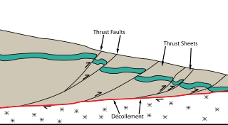
The Main Himalayan Thrust (MHT) is a décollement under the Himalaya Range. This thrust fault follows a NW-SE strike, reminiscent of an arc, and gently dips about 10 degrees towards the north, beneath the region. It is the largest active continental megathrust fault in the world.
The 1840 Ahora earthquake occurred on 2 July at 16:00 local time, affecting Ağrı Province in the Eastern Anatolia Region of present-day Turkey and Armenia. The earthquake had an epicenter near Mount Ararat, where it triggered an eruption and caused a landslide that destroyed villages. An estimated 10,000 people were killed by the earthquake and its damaging aftershocks. Earthquake catalogs place the surface-wave magnitude at Ms 7.4 and maximum Modified Mercalli intensity scale assigned IX (Violent).
The 1858 Prome earthquake occurred on August 24 at 15:38 local time in British Burma. The earthquake occurred with a magnitude of 7.6–8.3 on the moment magnitude scale. It had an epicenter in near the city of Pyay (Prome), Bago. The shock was felt with a maximum Modified Mercalli intensity of XI (Extreme) for about one minute. Severe damage was reported in Bago, and off the coast of Rakhine, an island sunk.
The 1941 Hyūga-nada earthquake occurred off the coast of Kyushu, Japan at 19:02 local time on November 19. The earthquake measured 8.0 Mw and had a depth of 35 km (22 mi). A JMA seismic intensity of 5 was observed in Miyazaki City and Nobeoka City in Miyazaki Prefecture, and Hitoyoshi City in Kumamoto Prefecture. Due to the earthquake, a tsunami with a maximum wave height of 1.2 m was observed in Kyushu and Shikoku. The tsunami washed away many ships. Twenty-seven homes were destroyed and two people were killed. In Miyazaki, Ōita and Kagoshima prefectures, telephone services were disrupted. Subsidence by 8 cm (3.1 in) was recorded at Hyūga, Miyazaki. At Nobeoka, stone walls and embankments were damaged while roads cracked. It was felt as far as central Honshu.
The 1992 Joshua Tree earthquake occurred at 9:50:25 p.m. PDT on April 22 in Southern California. The magnitude 6.2 earthquake struck under the Little San Bernardino Mountains, near the town of Joshua Tree, California. Though no deaths were reported, the earthquake caused 32 injuries. A maximum Mercalli intensity of VII was observed in Joshua Tree and caused light to moderate damage. The event preceded the Landers and Big Bear earthquakes by two months but is now recognized as the beginning of a series of major earthquakes that culminated in two events on June 28, 1992.
References
- NGDC (1972), Significant Earthquake Database (Data Set), National Geophysical Data Center, NOAA, doi:10.7289/V5TD9V7K