List of earthquakes in Germany

Last updated

Earthquake zones in Germany Erdbebenzonen.png
Earthquake zones in Germany

Earthquakes in Germany are relatively weak but occur several times a year, some of them in coal mining areas where blasting sets them off. Following a 4.0 quake, attributed to mining and centered in Saarwellingen, around 1,000 demonstrators protested on 24 February 2008, demanding an end to mining work. Reportedly, the tremor knocked over chimneys and caused power outages. [1]

Contents

Most of the quakes occur in a seismically active zone associated with the Rhine Rift Valley that extends from the Swiss city of Basel into the Benelux countries, in particular in the "Cologne Bight". There are also earthquake zones on the northern edge of the Alps, around Lake Constance, in the Vogtland, around Gera and in the Leipzig plain. [2] [3]

Geology

Germany is transected by parts of the European Cenozoic Rift System, particularly the Upper and Lower Rhine Grabens, and these areas remain tectonically active today. This zone of intraplate deformation is caused by the continuing effects of the Alpine orogeny as the African Plate continues to push northwards into the Eurasian Plate. [4]

Seismologists consider earthquakes up to 6.4 on the Richter scale theoretically possible in the Lower Rhine Graben seismic zone. [5] Earthquakes there occur sporadically and at magnitudes that are relatively low by international standards. However, the region is the most seismically active and experiences the strongest quakes in Germany. A strong earthquake (approximately 5.5 to 6.0 on the Richter scale) occurs there approximately every 200 years on average. A stronger earthquake would endanger cities including Aachen, Bonn, Düren, Düsseldorf, Grevenbroich, Heinsberg, Koblenz, Mönchengladbach, Cologne and Leverkusen as well as cities in the Netherlands including Roermond, Maastricht and Sittard and in Belgium including Eupen and Liège.

Notable earthquakes

1356 Basel earthquake

On 18 October 1356, an earthquake with its epicentre between Waldkirch and St. Peter in Breisgau-Hochschwarzwald destroyed the city of Basel in Switzerland and killed at least 300 people there alone; there was widespread damage from the quake and its precursor and aftershocks, and the main quake, estimated at 6.2 to 6.5 Mw, was felt as far away as Paris.

1756 Düren earthquake

On 18 February 1756, at about 8 am, one of the strongest earthquakes in Central Europe, the strongest reported in Germany to date, struck Düren. [2] [6] The hypocentre is judged to have been at 14–16 km. [7] It followed the 1755 Lisbon earthquake by several months and was the culmination of a series of quakes in Germany that had lasted several years. Buildings were damaged in Cologne, Aachen, Jülich and Bad Münstereifel; shaking was felt in London, Magdeburg and Strasbourg. Based on damage reports, the quake was assessed at VIII on the Mercalli intensity scale, [8] and is today thought to have been approximately 6.1 [2] or 6.4 [8] on the Richter scale. The earthquake caused two deaths and severe damage in Düren, two deaths and one serious injury in Cologne. Portions of the city walls collapsed in Düren and Bad Münstereifel. Some of the hot springs in Aachen ran dry, while others increased in strength. A spring at Breinigerberg ran dry. The water table fell in open tin and lead mines; some became dry. [9]

1951 Euskirchen earthquake

On 14 March 1951, shortly before 11 am, a magnitude 5.8 quake with epicentre near Euskirchen injured 11 people and caused significant damage. Chimneys and roof tiles fell. Many people in Cologne took refuge in bomb shelters. [10] This earthquake led to the establishment of the earthquake monitoring centre at Bensberg to provide data on seismic activity in the Rhineland. [11] [12]

1992 Roermond earthquake

On 13 April 1992 at 3:20 am, a 5.3 Mw [13] quake with its epicentre 4 km southwest of Roermond, the Netherlands, and its hypocentre 18 km deep shook the border region for 15 seconds. [14] 30 people were injured in North Rhine-Westphalia alone, mostly by falling roof tiles and chimneys, [15] and there was considerable damage to buildings. Ground shifts of up to 2 m occurred, and sand fountains in a few locations. [16] [17] [18] The quake was felt as far away as Milan and London. The worst damage in Germany was in Heinsberg; [10] in the Netherlands the area of damage extended several kilometres northwest of Roermond. Total damage costs in Germany topped 150 million DM, in the Netherlands, 170 million guilders. [14] [15] Aftershocks continued until 31 May. [15]

2009 Moers earthquake

On 24 July 2009 at 4:58 am, an earthquake with a magnitude of 3.3 MW struck in western Germany, 20 km (12 mi) northwest of the city of Duisburg. [19] [20] [21] The Geological Service of North Rhine-Westphalia announced the connection with mining confirmed by a 3.1 magnitude aftershock on 31 July 2009. [22]

2011 Koblenz earthquake

A 4.4 magnitude earthquake struck western Germany on 14 February 2011, at 13:43 local time. The earthquake epicenter was at Nassau an der Lahn, 65 km (40 mi) WNW from Frankfurt am Main. There were no immediate reports of damage. [23] [24]

Other earthquakes in Germany

DateLocationMagnitudeDamage / other notes
813 Aachen unknownDamage to royal chapel and collapse of passageway between it and the palace.
829AachenunknownSome damaged buildings
1223 Cologne unknown
1348 Altenberg unknown
18 September 1640 Düren unknownDamage to houses in Düren and Cologne.
1661 Dortmund unknownTower of St. Reinoldi's church damaged; later collapsed.
16 February 1673RemagenunknownEarthquake destroyed parts of the castle at Rolandseck.
1692AachenunknownTower of St. Augustine's church collapsed.
26–27 December 1755AachenunknownSeveral moderate earthquakes in the Aachen area.
19 January 1757Aachen [25] unknown
1758Aachen [25] unknown
1759Aachen [25] unknown
9 June 1771Aachen [25] unknown
15–16 July 1773Aachen [25] unknown
23 February 1828Aachen [25] unknown
19, 22, 31 October 1873 Herzogenrath unknownDamaged buildings reported.
1877HerzogenrathunknownDamaging quake
26 August 1878 Tollhausen unknownOne person killed, damage to buildings. In Aachen numerous fallen chimneys, damaged buildings.
18 November 1881AachenunknownStrong quake felt in Aachen, Cologne, Düsseldorf, Arnsberg, Münster, and parts of Belgium and the Netherlands; aftershock on 24 November. [26]
4 October 1886 Thuringia unknown"Violent earthquake shocks have occurred throughout Thuringia and other parts of Central Germany." [27]
16 November 1911near Albstadt on the Swabian Alb ML=6.1 [2]
20, 23 November 1932Aachenunknown
22 January 1970 Tübingen unknowna quake in Baden-Württemberg shook the metre-thick walls of the castle tower in Tübingen [10] and caused damage to the pilgrimage church of Maria Zell near Hechingen that took 4 years to repair. [28]
19 February 1971 Roermond, Netherlands ML=4.7Earthquake with epicentre near the German border
2 June 1977 Soltau [29] 4.0
3 September 1978 Swabian Alb ML=5.7The Hohenzollern Castle, home of the German Kaisers, was closed after sustaining extensive damage due to an earthquake in the Swabian Alb. 15 persons were reported injured in Tailfingen, Burladingen and Onstmettingen. [30] 20 people had to be dug out of rubble. [10]
24 May 1982 Waldfeucht ML=3.2
1983 Liège ML=5.1
11 December 1985 Simpelveld, Netherlands ML=2, 3.5Two earthquakes across the border at Simpelveld in the Netherlands, registering 2 and 3.5 on the Richter scale.
13 March 1989 Vacha 5.7Blasting at a potash mine in East Germany was blamed for a quake measured at 5.7 and felt in neighboring West Germany as well. Three villagers in the East German village of Vacha were injured. [31]
22 July 2002 Alsdorf 5.0At 7:41 am, magnitude 5.0, VI on the Mercalli scale at the epicentre, at a depth of 14.4 km: no injuries, some damage to buildings. The quake was felt in some parts of the Ruhr.
20 October 2004 Neuenkirchen 4.5Before 9:00 am, a 4.5 quake, largest in the area since 1977. [32]
5 December 2004 Waldkirch 5.2Epicenter in Waldkirch close to Freiburg im Breisgau. Damage worth 10 million euros, mostly from cracks in walls. [33]
3 August 2007 Plaidt 3.9At 4:58 am, a magnitude 3.9 quake, felt in Koblenz, Westerwaldkreis, Rhein-Sieg-Kreis, Euskirchen, Bonn and Cologne. [34]
12 December 2007 Duisburg 3.2
24 January 2008 Duisburg 3.0
10 September 2009 Westerwaldkreis 2.7At 2:40 pm, a magnitude 2.7 quake with epicentre at Eitelborn caused alarm in Montabaur, Neuwied, and Bad Ems. [35]
8 September 2011 Xanten 4.5At 9:04 pm, a magnitude 4.5 quake with epicentre at Xanten.
30 March 2014 Darmstadt 3.2At 5:48 pm, an M3.2 quake hit Darmstadt
17 May 2014 Darmstadt 4.2At 6.46 pm, Darmstadt was hit by a magnitude 4.2 quake. [36]
8 June 2014 Darmstadt 3.3An M3.3 earthquake hit Darmstadt at 4:15 pm
30 July 2019 Konstanz 3.7An M3.7 earthquake hit Konstanz at 1:17 am [37]
29 August 2019 Konstanz/Dettingen  [ de ]3.5An M3.5 earthquake hit Konstanz/Dettingen  [ de ] at 4:22 pm [38]

Related Research Articles

<span class="mw-page-title-main">Aachen</span> City in North Rhine-Westphalia, Germany

Aachen is the 13th-largest city in North Rhine-Westphalia and the 27th-largest city of Germany, with around 252,000 inhabitants.

<span class="mw-page-title-main">Düren</span> Town in North Rhine-Westphalia, Germany

Düren is a town in North Rhine-Westphalia, Germany, between Aachen and Cologne, on the river Rur.

<span class="mw-page-title-main">Cologne–Aachen high-speed railway</span> German part of the high-speed line Paris–Brussels–Cologne

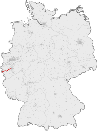
The Cologne–Aachen high-speed line is the German part of the Trans-European transport networks project high-speed line Paris–Brussels–Cologne. It is not a newly built railway line, but a project to upgrade the existing railway line which was opened in 1841 by the Rhenish Railway Company. When it was continued into Belgium in 1843, it became the world's first international railway line.

<span class="mw-page-title-main">2003 Alabama earthquake</span> Earthquake near Fort Payne, Alabama in 2003

The 2003 Alabama earthquake took place on April 29 at 3:59 A.M. Central Daylight Time eight miles (13 km) east-northeast of Fort Payne, Alabama. The number of people who felt this quake was exceptionally high as the earthquake could be felt in 11 states across the East Coast and as far north as southern Indiana. The earthquake was strongly felt throughout metropolitan Atlanta. The Georgia Building Authority was called out to inspect the historic Georgia State Capitol in downtown Atlanta and other state-owned buildings but found no problems. However, this is not out of the ordinary as earthquakes east of the Rocky Mountains can be felt several times the area felt on West Coast earthquakes. The earthquake was given a magnitude 4.6 on the moment magnitude scale by the USGS and reports of the duration of the shaking range from 10 seconds to as long as 45 seconds. It is tied with a 1973 earthquake near Knoxville, Tennessee as the strongest earthquake ever to occur in the Eastern Tennessee Seismic Zone, which is the second most active seismic zone east of the Rocky Mountains, with the New Madrid Seismic Zone the most active.

<span class="mw-page-title-main">1356 Basel earthquake</span> 6.0–7.1 Mw earthquake in Switzerland

The 1356 Basel earthquake is the most significant seismological event to have occurred in Central Europe in recorded history and had a moment magnitude in the range of 6.0–7.1. This earthquake, which occurred on 18 October 1356, is also known as the Sankt-Lukas-Tag Erdbeben, as 18 October is the feast day of Saint Luke the Evangelist.

<span class="mw-page-title-main">Neuss Hauptbahnhof</span> Railway station in Neuss, North Rhine-Westphalia

Neuss Central Station is the railway station for the city of Neuss in the German state of North Rhine-Westphalia. The main station building is built on a platform between the tracks and it is located at the junction of the Lower Left Rhine Railway and the Mönchengladbach–Düsseldorf railway. These lines also connect with the Düren–Neuss railway and the Neuss–Viersen railway; the latter has ended since 1984 at Kaarster See station and is operated by the private Regiobahn company.

<span class="mw-page-title-main">Wabash Valley Seismic Zone</span>

The Wabash Valley Seismic Zone is a tectonic region located in the Midwestern United States, centered on the valley of the Lower Wabash River, along the state line between southeastern Illinois and southwestern Indiana.

<span class="mw-page-title-main">Düren station</span>

Düren station is located to the north of the centre of Düren and is the largest station in the city and the district of Düren. It is located at the intersection of the Cologne–Aachen high-speed line with the lines to Linnich, Heimbach and Euskirchen. Until 1992 it was also connected to the Erft Railway.

<span class="mw-page-title-main">Horrem station</span>

Horrem station is a station in the Kerpen district of Horrem in the German state of North Rhine-Westphalia. It is a railway junction of the Cologne–Aachen high-speed railway and the Erft Railway. The triangular station of Horrem is served by regional services and by S-Bahn trains of the Rhine-Ruhr S-Bahn. Long-distance trains run through on the high-speed line without stopping. It is classified by Deutsche Bahn as a category 3 station.

<span class="mw-page-title-main">Frechen-Königsdorf station</span>

Frechen-Königsdorf station is a station in the village of Königsdorf in the German state of North Rhine-Westphalia on the Cologne–Aachen high-speed railway.

<span class="mw-page-title-main">Sindorf station</span>

Sindorf station is a train station in the town of Sindorf in the German state of North Rhine-Westphalia on the Cologne–Aachen high-speed railway. The station is in the south-east of the Kerpen district of Sindorf and has a side platform on the south side of the S-Bahn line. This is bounded to the south by a noise barrier and the entrances and exits are at the ends of the platform.

The 1992 Roermond earthquake occurred on 13 April, around 3:20 AM with a moment magnitude of 5.3 and a maximum Mercalli intensity of VIII (Severe). Striking on the Peel Boundary Fault, a normal fault near Roermond, it was the strongest recorded earthquake in the Netherlands and in Northwestern Europe, and caused substantial damage to older buildings in the Netherlands and adjacent countries of Belgium and Germany. A series of aftershocks followed.

<span class="mw-page-title-main">Oklahoma earthquake swarms (2009–present)</span> Series of earthquakes in central Oklahoma, southern Kansas, and northern Texas

The Oklahoma earthquake swarms are an ongoing series of human activity-induced earthquakes affecting central Oklahoma, southern Kansas, northern Texas since 2009. Beginning in 2009, the frequency of earthquakes in the U.S. state of Oklahoma rapidly increased from an average of fewer than two 3.0+ magnitude earthquakes per year since 1978 to hundreds each year in the 2014–17 period. Thousands of earthquakes have occurred in Oklahoma and surrounding areas in southern Kansas and North Texas since 2009. Scientific studies attribute the rise in earthquakes to the disposal of wastewater produced during oil extraction that has been injected more deeply into the ground.

<span class="mw-page-title-main">October 2016 Central Italy earthquakes</span>

A series of major earthquakes struck Central Italy between the Marche and Umbria regions in October 2016. The third quake on 30 October was the largest in Italy in 36 years, since the 1980 Irpinia earthquake.

<span class="mw-page-title-main">Insheim Geothermal Power Station</span>

The Insheim Geothermal Power Station is a geothermal power station in Rhineland-Palatinate.

The 1756 Düren earthquake occurred on the morning at 8 a.m. near the town of Düren with a magnitude of 6.4 on the Richter scale. It was one of the strongest earthquakes in Central Europe, and the strongest in Germany's recorded history. The depth of the hypocenter is estimated at 14–16 kilometres (8.7–9.9 mi). This earthquake may have been a remotely triggered event from the 1755 earthquake in Lisbon, but there is not enough evidence for this.

The 1692 Verviers earthquake, also known as the 1692 Ardennes earthquake, occurred in the east of Belgium on 18 September 1692 measuring around 6.2 on the Richter scale. Parish records and historical accounts strongly indicate the earthquake's epicenter was northwest of Verviers, and the event was widely felt across Western Europe in modern-day Belgium, England, Germany, the Netherlands, Luxembourg, and France. The largest amount of damage occurred in the northwestern environs of Verviers, then part of the Prince-Bishopric of Liège. Researchers at the Royal Observatory of Belgium have considered this the strongest known earthquake in Western Europe north of the Alps, which occurred as part of a sequence of quakes from the Lower Rhine Graben in September 1692.

<span class="mw-page-title-main">Jewish Cemetery, Aachen</span> Cemetery in Aachen, Germany

The Jewish Cemetery Aachen is located in Aachen in North Rhine-Westphalia. It is on the corner of Lütticher Straße and Körnerstraße.

References

  1. "Quake Shakes Western Germany", SkyNews, 24 February 2008
  2. 1 2 3 4 "Where in Germany does the earth quake?: Seismicity (or earthquake activity) in Germany". Deutsches GeoForschungsZentrum (German Research Centre for Geosciences). Retrieved 29 May 2010.
  3. Bundesanstalt für Geowissenschaften und Rohstoffe (BGR) Epizentrenkarten der Bundesrepublik Deutschland mit Randgebieten [ permanent dead link ] (German), retrieved 26 May 2010.
  4. "System Explanation of Earthquakes in Germany and Central Europe", Natural Disasters Networking Platform, quoting from G. Grünthal, "Erdbeben und Erdbebengefährdung in Deutschland sowie im europäischen Kontext", Geographie und Schule 151 (2004), 14–23
  5. Klaus-G. Hinzen and Sharon K. Reamer, "Seismicity, seismotectonics, and seismic hazard in the northern Rhine area", Geological Society of America special papers, Abstract, 29 November 2006, retrieved 29 May 2010, refers to a maximum magnitude of 7.0.
  6. University of Cologne Erdbebenstation Bensberg, Zum 250. Jahrestag des Dürener Erdbebens (On the 250th anniversary of the Düren earthquake) (German), retrieved 26 May 2010.
  7. BGR Erdbebenkatalog EU, 1756/02/18 and Erdbebenkatalog für die Bundesrepublik Deutschland, 1756 02 18 (German).
  8. 1 2 BGR Deutscher historischer Erdbebenkatalog ab dem Jahre 800, ZIP file downloadable from Erdbebenkatalog für die Bundesrepublik Deutschland mit Randgebieten Archived 2011-07-16 at archive.today (German).
  9. Johann Peter Joseph Monheim, Die Heilquellen von Aachen, Burtscheid, Spaa, Malmedy und Heilstein in ihren historischen, geognostischen, physischen, chemischen und medizinischen Beziehungen, Aachen: J.A. Mayer, 1829, p. 260 (German).
  10. 1 2 3 4 "Schwingende Glocke: Das stärkste Erdbeben seit 1756 erschütterte am Anfang der Woche das Rheinland und die deutschen Gemüter" (Swinging Bells: The strongest earthquake since 1756 shook the Rhineland and German spirits at the beginning of the week"), Der Spiegel 20 April 1992 (German).
  11. Erdbebenstation Bensberg – Die Geschichte der Erdbebenstation Bensberg (The History of the Bensberg Earthquake Station), 19 May 2010 (German), retrieved 25 May 2010.
  12. Ludwig Ahorner, Geschichte der Erdbebenstation Bensberg Archived 2011-08-07 at the Wayback Machine (History of the Bensberg Earthquake Station), Zur Geschichte der Geophysik in Deutschland, 29 February 2008 (German), retrieved 3 June 2010.
  13. GeoForschungs Zentrum Potsdam. "An earthquake catalogue for central, northern and northwestern Europe based on Mw magnitudes / Annex. STR 03/02" (PDF). Retrieved 5 February 2011.
  14. 1 2 Royal Netherlands Meteorological Institute (KNMI), De aardbeving bij Roermond 13 april 1992 Archived 12 December 2009 at the Wayback Machine , 13 April 1992, revised 20 April 1992 (Dutch), retrieved 26 May 2010.
  15. 1 2 3 North Rhine Westphalia Geological Service, Erdbeben bei Roermond am 13. April 1992 Archived 2013-10-29 at the Wayback Machine (German), retrieved 26 May 2010.
  16. Photograph of split ground on the banks of the River Maas near Roermond Archived 2011-03-25 at the Wayback Machine , KNMI, retrieved 26 May 2010.
  17. Photograph of split ground on Brunssum Heathland Archived 2011-03-25 at the Wayback Machine , KNMI, retrieved 26 May 2010.
  18. Photograph of aftermath of sand fountaining in a field at Herkenbosch Archived 2011-03-25 at the Wayback Machine , KNMI, retrieved 26 May 2010.
  19. 2009 list of earthquakes, Erdbebenstation Bensberg, University of Cologne, retrieved 23 May 2010: location given as Moers Repelen.
  20. Christian Schwerdtfeger, Stärkstes Erdbeben seit 1955 ("The Strongest Earthquake Since 1955"), RP Online, 24 July 2009 (German), retrieved 23 May 2010.
  21. "Preliminary Earthquake Report" Archived 2009-04-11 at the Wayback Machine Official website, U.S. Department of the Interior, U.S. Geological Survey: giving an initial assessment of 4.1. Retrieved 19 May 2010.
  22. Erneuter starker Erdstoß bei Moers / Kamp-Lintfort Archived 2011-07-19 at the Wayback Machine ("Another strong earthquake in Moers/Kamp-Lintfort"), Geologischer Dienst NRW, July 31, 2009 (German), retrieved 23 May 2010.
  23. "US Geological Service". Archived from the original on 2011-02-17. Retrieved 2017-09-03.
  24. "Koblenz: Leichtes Erdbeben in der Region Mittelrhein", Südwestrundfunk 14 February 2011 (in German)
  25. 1 2 3 4 5 6 Monheim, p. 261 (German).
  26. Pauels, A.(1997). Unter Adler und Schwan – Die Chronik der Bürgermeisterei Burtscheid für die Jahre 1814–1886., p. 246 (German).
  27. "The Earthquake in Germany". Rock Island Daily Argus. 4 October 1886. p. 1. Retrieved 24 November 2022.
  28. Baugeschichte (History of the Building), Wallfahrtskirche Maria Zell, 4 September 2006 (German), retrieved 3 June 2010. The church has been damaged by other earthquakes before and since.
  29. ""Earthquake jolts northern Germany"". Archived from the original on 2012-09-10. Retrieved 2010-05-30.
  30. "Damage Heavy As Big Quake Rocks Germany" Archived 2016-05-07 at the Wayback Machine , The Milwaukee Sentinel (Spokane), 4 September 1978, p2
  31. "Strong quake shakes Germany", Spokane Chronicle, 13 March 1989, p. 1; "Earthquake rocks both Germanys", Chicago Tribune, 14 March 1989, p. 16.
  32. "Earthquake jolts northern Germany" Archived 2012-09-10 at the Wayback Machine , Expatica.com, 20 October 2004, retrieved 1 June 2010.
  33. , GEOFON Program, Deutsches GeoForschungsZentrum
  34. Erdbebenstation Bensberg: Tektonisches Erdbeben bei Plaidt (Tectonic Earthquake at Plaidt), 3 August 2007 (German).
  35. Erdbeben der Stärke 2,7 Archived 2012-09-05 at archive.today , noows.de, 10 September 2009 (German), retrieved 26 May 2010.
  36. , news-round.com, May 17, 2014.
  37. "SED | Switzerland".
  38. "Quake info: Light mag. 3.5 earthquake - Freiburg Region, 5.1 km southwest of Überlingen, Germany, on Thursday, 29 August 2019 at 14:22 (GMT) - 170 user experience reports".