This article needs additional citations for verification .(September 2012) |
The following lists include extreme and significant points of the geography of Canada.
This article needs additional citations for verification .(September 2012) |
The following lists include extreme and significant points of the geography of Canada.

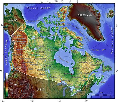
Canada has a vast geography that occupies much of the continent of North America, sharing a land border with the contiguous United States to the south and the U.S. state of Alaska to the northwest. Canada stretches from the Atlantic Ocean in the east to the Pacific Ocean in the west; to the north lies the Arctic Ocean. Greenland is to the northeast with a shared border on Hans Island. To the southeast Canada shares a maritime boundary with France's overseas collectivity of Saint Pierre and Miquelon, the last vestige of New France. By total area, Canada is the second-largest country in the world, after Russia. By land area alone, however, Canada ranks fourth, the difference being due to it having the world's largest proportion of fresh water lakes. Of Canada's thirteen provinces and territories, only two are landlocked while the other eleven all directly border one of three oceans.

The Canadian Shield, also called the Laurentian Plateau, is a geologic shield, a large area of exposed Precambrian igneous and high-grade metamorphic rocks. It forms the North American Craton, the ancient geologic core of the North American continent. Glaciation has left the area with only a thin layer of soil, through which exposures of igneous bedrock resulting from its long volcanic history are frequently visible. As a deep, common, joined bedrock region in eastern and central Canada, the shield stretches north from the Great Lakes to the Arctic Ocean, covering over half of Canada and most of Greenland; it also extends south into the northern reaches of the United States.

Ellesmere Island is Canada's northernmost and third largest island, and the tenth largest in the world. It comprises an area of 196,236 km2 (75,767 sq mi), slightly smaller than Great Britain, and the total length of the island is 830 km (520 mi).

The Arctic Archipelago, also known as the Canadian Arctic Archipelago, is an archipelago lying to the north of the Canadian continental mainland, excluding Greenland and Iceland.
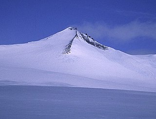
Barbeau Peak is a mountain in Qikiqtaaluk, Nunavut, Canada. Located on Ellesmere Island within Quttinirpaaq National Park, it is the highest mountain in Nunavut and the Canadian Arctic. The mountain was named in 1969 after Marius Barbeau, a Canadian anthropologist whose research into First Nations and Inuit cultures gained him international acclaim.

This is a list of the extreme points of North America: the points that are highest and lowest, and farther north, south, east or west than any other location on the continent. Some of these points are debatable, given the varying definitions of North America.
This is a list of the extreme points of The Americas, the points that are farther north, south, east or west than any other location on the continent. The continent's southernmost point is often said to be Cape Horn, which is the southernmost point of the Chilean islands. The Americas cross 134° of longitude east to west and 124° of latitude north to south.
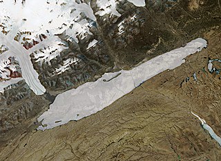
Lake Hazen is a freshwater lake in the northern part of Ellesmere Island, Nunavut, Canada, north of the Arctic Circle. It is the largest lake north of the Arctic Circle by volume. By surface area it is third largest, after Lake Taymyr in Russia and Lake Inari in Finland.
Geoffrey Francis Hattersley-Smith D.Phil, FRSC, FRGS, FAINA was an English-born Canadian geologist and glaciologist, recognized as a pioneering researcher of Northern Canada.
The Canadian territory of Nunavut covers about 1.9 million square kilometres of land and water including part of the mainland, most of the Arctic islands, and all of the islands in Hudson Bay, James Bay, and Ungava Bay which belonged to the Northwest Territories. This makes it the fifth largest country subdivision in the world. If Nunavut were a country, it would rank 13th in area, after the Democratic Republic of the Congo. Nunavut has land borders with Manitoba, the Northwest Territories on several islands as well as the mainland, and a tiny land border with Newfoundland and Labrador on Killiniq Island.

This article comprises three sortable tables of major mountain peaks of Canada.

Mount Odin is a mountain in Qikiqtaaluk, Nunavut, Canada. It is located in Auyuittuq National Park along the Akshayuk Pass, 46 km (29 mi) north of Pangnirtung and south of Mount Asgard. Mount Odin is the highest mountain on Baffin Island.

The following outline is provided as an overview of and topical guide to Canada:
The borders of Canada include:
