
Lake Michigan is one of the five Great Lakes of North America. It is the second-largest of the Great Lakes by volume and the third-largest by surface area, after Lake Superior and Lake Huron. To the east, its basin is conjoined with that of Lake Huron through the 3+1⁄2-mile (5.6-kilometer) wide, 295-foot deep Straits of Mackinac, giving it the same surface elevation as its easterly counterpart; the two are geologically a single lake.
The Lower Peninsula of Michigan – also known as Lower Michigan – is the larger, southern and less elevated of the two major landmasses that make up the U.S. state of Michigan; the other being the Upper Peninsula, which is separated by the Straits of Mackinac. It is surrounded by water on all sides except its southern border, which it shares with Indiana and Ohio. Although the Upper Peninsula is commonly referred to as "the U.P.", it is uncommon for the Lower Peninsula to be called "the L.P."

Lake Huron is one of the five Great Lakes of North America. Hydrologically, it comprises the easterly portion of Lake Michigan–Huron, having the same surface elevation as Lake Michigan, to which it is connected by the 5-mile-wide (8.0 km), 20-fathom-deep Straits of Mackinac. It is shared on the north and east by the Canadian province of Ontario and on the south and west by the U.S. state of Michigan. The name of the lake is derived from early French explorers who named it for the indigenous people they knew as Huron (Wyandot) inhabiting the region.

Hiawatha National Forest is a 894,836-acre (362,127 ha) National Forest in the Upper Peninsula of the state of Michigan in the United States. Commercial logging is conducted in some areas. The United States Forest Service administers this National Forest; it is physically divided into two subunits, commonly called the Eastside 46°14′N84°50′W and Westside 46°08′N86°40′W.
The following is an alphabetical list of articles related to the U.S. state of Michigan.
The Thumb is a region and a peninsula of the U.S. state of Michigan, so named because the Lower Peninsula is shaped like a mitten. The Thumb area is generally considered to be in the Central Michigan region, east of the Tri-Cities and north of Metro Detroit. The region is also branded as the Blue Water Area.

Northern Michigan, also known as Northern Lower Michigan, is a region of the U.S. state of Michigan. A popular tourist destination, it is home to several small- to medium-sized cities, extensive state and national forests, lakes and rivers, and a large portion of Great Lakes shoreline. The region has a significant seasonal population much like other regions that depend on tourism as their main industry. Northern Lower Michigan is distinct from the more northerly Upper Peninsula and Isle Royale, which are also located in "northern" Michigan. In the northernmost 21 counties in the Lower Peninsula of Michigan, the total population of the region is 506,658 people.
Gull Island is the name of a dozen small islands in the U.S. state of Michigan.

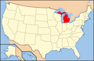
Michigan consists of two peninsulas surrounded primarily by four of the Great Lakes and a variety of nearby islands. The Upper Peninsula is bounded on the southwest by Wisconsin, and the Lower Peninsula is bounded on the south by Indiana and Ohio. Both land masses are also separated from the Canadian province of Ontario by waterways of the Great Lakes, and from each other by the Straits of Mackinac. Because its land is largely surrounded by the Great Lakes, which flow into the Saint Lawrence River, Michigan is the only U.S. state whose streams and rivers are almost entirely within the Great Lakes-St. Lawrence watershed.
Lake State Railway is a railroad operating in the Saginaw Valley and northeastern quadrant of the Lower Peninsula of Michigan. The railroad moves large quantities of aggregate and limestone, as well as coal, grain, and chemical products. Some of the company's largest customers include Dow Chemical Company, S. C. Johnson & Son, Lafarge, ConAgra Foods, Archer Daniels Midland, Conrad Yelvington Distributors, and Consumers Energy.

Due to its unique geography, being made of two peninsulas surrounded by the Great Lakes, Michigan has depended on many ferries for connections to transport people, vehicles and trade. The most famous modern ferries are those which carry people and goods across the Straits of Mackinac to the car-free Mackinac Island but before the Mackinac Bridge was built, large numbers of ferries carried people and cars between the two peninsulas. Other ferries continue to provide transportation to small islands and across the Detroit River to Canada. Ferries once provided transport to island parks for city dwellers. The state's only national park, Isle Royale cannot be reached by road and is normally accessed by ferry. The largest ferries in Michigan are the car ferries which cross Lake Michigan to Wisconsin. One of these, the SS Badger is one of the last remaining coal steamers on the Great Lakes and serves as a section of US Highway 10 (US 10). The Badger is also the largest ferry in Michigan, capable of carrying 600 passengers and 180 autos.

The United States Lake Survey (USLS) was a hydrographic survey for the Great Lakes, New York Barge Canal, Lake Champlain and the Boundary Waters of the Canada–United States border between Minnesota and Ontario. The Survey's activities began on 31 March 1841, with the goal of surveying the Great Lakes. The Lake Survey was created within the United States Army Topographical Engineers. Like the Commerce Department's United States Coast and Geodetic Survey, the Lake Survey had responsibility for the preparation and publication of nautical charts and other navigational aids. By 1882, the Survey had completed the original Congressional mandate, producing 76 charts, then disbanded. By 1901, the original survey and charting products required revision. The Lake Survey was reconstituted and its mission expanded. In addition to traditional survey, charting, and navigation information responsibilities, the Lake Survey was also responsible for studies on lake levels and associated river flow.