Guam is a U.S. territory in the western Pacific Ocean, at the boundary of the Philippine Sea. It is the southernmost and largest member of the Mariana Islands archipelago, which is itself the northernmost group of islands in Micronesia. The closest political entity is the Commonwealth of the Northern Mariana Islands (CNMI), another U.S. territory. Guam shares maritime boundaries with CNMI to the north and the Federated States of Micronesia to the south. It is located approximately one quarter of the way from the Philippines to Hawaii. Its location and size make it strategically important. It is the only island with both a protected harbor and land for multiple airports between Asia and Hawaii, on an east–west axis, and between Papua New Guinea and Japan, on a north–south axis.

Territories of the United States are sub-national administrative divisions overseen by the federal government of the United States. The various American territories differ from the U.S. states and Indian reservations as they are not sovereign entities. In contrast, each state has a sovereignty separate from that of the federal government and each federally recognized Native American tribe possesses limited tribal sovereignty as a "dependent sovereign nation." Territories are classified by incorporation and whether they have an "organized" government through an organic act passed by the Congress. American territories are under American sovereignty and, consequently, may be treated as part of the United States proper in some ways and not others. Unincorporated territories in particular are not considered to be integral parts of the United States, and the Constitution of the United States applies only partially in those territories.
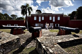
Frederiksted is both a town and one of the two administrative districts of St. Croix, U.S. Virgin Islands. It is a grid-planned city, designed by surveyor Jens Beckfor, originally to 14x14 blocks but built 7x7 to enhance the island commerce in the 1700s. Fewer than 1,000 people live in Frederiksted proper, but nearly 10,000 live on the greater western side of the island. Christiansted is about 30 years older, but commerce was limited by its natural, shallow protective reef. Frederiksted was built in the leeward side of the island for calm seas and a naturally deep port. It is home to Fort Frederik, constructed to protect the town from pirate raids and attacks from rival imperialist nations and named after Frederick V of Denmark, who purchased the Danish West Indies in 1754.
WVIS is a radio station licensed to serve Vieques, Puerto Rico. The station is owned by V.I. Stereo Communications Corporation (P.R.).

Yigo, Guam is the northernmost village of the United States territory of Guam, and is the location of Andersen Air Force Base. The municipality of Yigo is the largest village on the island in terms of area. It contains a number of populated places, including Asatdas and Agafo Gumas.

The Guam Museum, formally the Senator Antonio M. Palomo Guam Museum & Chamorro Educational Facility, is a museum focusing on the history of Guam, a U.S. territory in Micronesia. A permanent building to house the museum's collection opened in Hagåtña on November 4, 2016. The Guam Museum had been housed in temporary locations since World War II.

U.S. Virgin Islands Governor's Mansion may refer to any one of the three official residences owned by the government of the U.S. Virgin Islands and provided to the Governor of the United States Virgin Islands. One residence is located on each of the three largest inhabited islands of this U.S. territory in the Caribbean. The U.S. Virgin Islands maintains more official gubernatorial residences than any other state or territory of the United States.
The Yigo Guam Temple is a temple of the Church of Jesus Christ of Latter-day Saints in Yigo, Guam.
The Spanish–Chamorro Wars, also known as the Chamorro Wars and the Spanish–Chamorro War, refer to the late seventeenth century unrest among the Chamorros of the Mariana Islands in the western Pacific Ocean against the colonial effort of Habsburg Spain. Anger at proselytizing by the first permanent mission to Guam, which was led by Diego Luis de San Vitores, and a series of cultural misunderstandings led to increasing unrest on Guam and a Chamorro siege of the Hagåtña presidio incited by maga'låhi (Chief) Hurao in 1670. Maga'låhi Matå'pang killed San Vitores in 1672, resulting in a campaign of Spanish reprisal burnings of villages through 1676. Local anger at the attacks against villages resulted in another open rebellion led by Agualin and a second siege of Hagåtña. Governor Juan Antonio de Salas conducted a counter-insurgency campaign that successfully created a system of collaboration in which Guamanians turned in rebels and murderers and transferred most of the people from about 180 villages to seven towns, a policy known as reducción. By the early 1680s, Guam was largely "reduced," or pacified.

Sumay, also Sumai, was a village on the United States territory of Guam. It was located on the north coast of the Orote Peninsula along Apra Harbor. It was inhabited by Chamorro people before contact with Europeans. Sumay became a prosperous port town serving whalers and other sailors in the 1800s and the second most populous settlement on Guam after Hagåtña, the capital of the Spanish Mariana Islands. Following the Capture of Guam by the United States in 1898, the village was the site of Marine Barracks Guam. In the early 1900s, it was a link for two firsts connecting the United States and Asia: the first submarine communications cable for telegraph and the China Clipper, the first air service. After the Japanese invasion of Guam in 1941, the residents were evicted and the village turned into a Japanese military garrison. Sumay was leveled during the U.S. liberation of the island in 1944. The U.S. military prohibited the residents from returning, relocating them to the hills of nearby Sånta Rita-Sumai. In 1948, the U.S. military exercised eminent domain and took all private and commercial property at Sumay. Its former location is now on Naval Base Guam.

Liberation Day on the U.S. territory of Guam is an annual commemoration of the invasion by U.S. military forces on July 21, 1944, which ended the Japanese occupation that had begun in 1941. Begun in 1945, it is Guam's largest celebration. Festivities include a queen contest, summer carnival, fireworks display, and mile-long parade on Marine Corps Drive in Hagåtña from Adelup to Paseo de Susana, as well as solemn memorials and visits to massacre sites. It is organized by the Guam Island Fair Committee.

Latte Stone Park, officially Senator Angel Leon Guerrero Santos Latte Stone Memorial Park, is an urban park in Hagåtña, Guam. Established in the 1950s and operated by the Guam Department of Parks and Recreation, it is best known for its set of eight historical latte stones, which were transferred from their original site in Fena. The Park is located along the cliffline below the Governor's residence in Agana Heights and south of the Plaza de España. It is often visited by sightseers visiting central Hagåtña. The park also includes the entrances to two sets of caves that were constructed during the Japanese occupation (1941–1944) by forced laborers and that were listed in the National Register of Historic Places in 1991 as the Agana/Hagåtña Cliffline Fortifications.

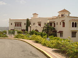
The Church of Jesus Christ of Latter-day Saints in the Mariana Islands refers to the organization and its members in the Mariana Islands. The Mariana Islands consist of two jurisdictions of the United States: the Commonwealth of the Northern Mariana Islands and, at the southern end of the chain, the territory of Guam. As of December 31, 2022, the LDS Church reported 2,547 members in one stake, five congregations, one mission, and one temple in Guam. There are 906 members in a ward in the Northern Mariana Islands. There are two family history centers, one in Guam and one at the Saipan Ward building in the Northern Mariana Islands.
The U.S. Naval Cemetery on Guam is located at Marine Corps Drive in East Hagåtña. Following the June 1898 capture of Guam, Article II of the December 10, 1898 Treaty of Paris transferred Guam, Puerto Rico and the Philippines to the United States control on December 23.