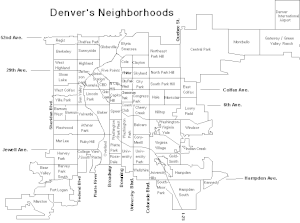
Located in the city and county of Denver, Colorado, the Capitol Hill neighborhood is bordered by Broadway, Downing Street, Colfax Avenue, and Seventh Avenue, which carry large volumes of traffic around the neighborhood. It is technically located in East Denver which begins immediately east of Broadway, the neighborhood's western boundary. Many consider the Cheesman Park neighborhood to be a part of the Capitol Hill neighborhood, but as defined by the city, Cheesman Park is a separate neighborhood. Denver also recognizes a statistical neighborhood called North Capitol Hill, also known as Uptown by some residents. Colfax Avenue is the border between these two neighborhoods.

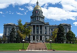
The Denver Civic Center is a civic center area that includes two parks surrounded by government and cultural buildings and spaces. Civic Center is located in central Denver, Colorado, on the south side of Downtown Denver. Much of the area is a historic district which was listed on the National Register of Historic Places in 1974. A somewhat smaller area was designated a U.S. National Historic Landmark in 2012 as one of the nation's finest examples of the City Beautiful movement of civic design. Denver Civic Center lies partially within the north end of an official Denver neighborhood also named Civic Center. It includes the Colorado State Capitol building, in the west end of Denver's official Capitol Hill neighborhood, and it includes a few buildings in the south end of Denver's Central Business District.

Civic Center, Denver is a neighborhood in Denver, Colorado, United States. The northern part of the neighborhood overlaps partially with the Denver Civic Center, an area of parks and civic buildings.
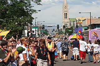
PrideFest is an annual gay pride event held each June in Denver, honoring the culture and heritage of the lesbian, gay, bisexual, and transgender community in the State of Colorado. The first Denver PrideFest occurred in 1976, the same year the local community center, now known as the Center on Colfax, was founded. The Center organizes and produces the festival and parade each year. The event currently consists of a two-day festival at Civic Center Park, the Pride 5K, and culminates with a parade along Colfax Avenue. Denver PrideFest now draws 525,000 guests annually, making it the third largest pride festival and seventh largest pride parade in the United States.

The City and County of Denver, Colorado, is located at 39°43'35" North, 104°57'56" West in the Colorado Front Range region. The Southern Rocky Mountains lie to the west of Denver and the High Plains lie to the east.

Highland is a distinct city-center neighborhood in Denver, Colorado, United States, bounded by West 38th Avenue to the north, a Union Pacific Railroad line on the east, the South Platte River to the southeast, Speer Boulevard on the south, and Federal Boulevard on the west. The Highlands is sometimes used to refer to two separate city-center neighborhoods in Denver; Highland and West Highland, although the two neighborhoods are distinct. Highland and West Highland are both in the area that is referred to as the Northside. Highland is located immediately northwest of downtown. Note that the Highland neighborhood association has a slightly different definition with the easternmost boundary stopping at I-25. And the West Highland neighborhood to the immediate west of Highland, with the borders of 38th and 29th Avenues on the north and south and Federal and Sheridan Boulevards on the east and west. To distinguish between its immediately adjacent neighbor, West Highland, Highland is sometimes referred to as East Highland, Lower Highland or LoHi. The two together are casually called "the Highlands," a term which often falsely encompasses other Northwest Denver neighborhoods such as Jefferson Park, Sunnyside and Berkeley. Realtors have particularly pushed the inclusion of the recently gentrified Berkeley, located directly north of West Highland, as part of the Highlands, sometimes going so far as to refer to Berkeley and parts of Sunnyside as the "Upper Highlands". To add further confusion, within the Highlands neighborhoods there are several historic designations of various degrees, including Potter Highlands, Scottish Highlands and Highlands Park.
The oldest part of Denver, Colorado, now the neighborhoods of Auraria Campus, LoDo, much of downtown, and Five Points, is laid out on a grid plan that is oriented diagonal to the four cardinal directions. The rest of the city, including the eastern part of downtown, is laid out primarily on a grid oriented to the cardinal directions. In this larger grid, from east to west, there are generally 16 city blocks per mile, except between Zuni Street and Lowell Boulevard in west Denver. From north to south, there are typically eight blocks per mile, although there are many areas with more blocks per mile. Addresses follow a decimal system, with addresses advancing by one hundred at each cross street.

There are 309 properties and districts listed on the National Register of Historic Places in the City and County of Denver, the capital of the U.S. State of Colorado.
This National Park Service list is complete through NPS recent listings posted March 1, 2024.

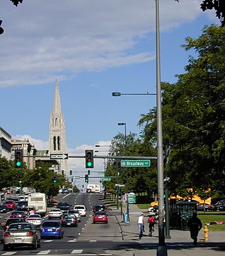
Downtown Denver is the main financial, commercial, business, and entertainment district in Denver, Colorado, United States. There is over 23 million square feet (2,100,000 m2) of office space in downtown Denver, with 132,000 workers. The downtown area consists mostly of the neighborhoods of Union Station and Central Business District. LoDo and RiNo are notable districts within downtown. Some of the more popular specific attractions include the 16th Street pedestrian mall, Larimer Square, the re-emerging Theatre District near Curtis and 14th, and Civic Center Park. Surrounding neighborhoods include Capitol Hill and Uptown to the east, Highland to the west, Five Points to the north, and the Golden Triangle to the south.
Arapahoe County was a county of the extralegal United States Territory of Jefferson that existed from November 28, 1859, until February 28, 1861. The county name was also spelled Arapaho County, Arapahoe County, Arrapahoe County, and Arappahoe County. The county seat was Denver City.

Lincoln Park is a neighborhood and public park close to downtown Denver, Colorado and the location of the Art District on Santa Fe. The neighborhood is one of Denver's oldest and is just to the south of the area where Denver was first settled in the 1850s. Many houses date from about 1900. The neighborhood is sometimes called "La Alma/Lincoln Park" or the West Side.

North Capitol Hill, often referred to as Uptown, is a center city neighborhood near the Colorado State Capitol. The neighborhood has a diverse population, and is similar to surrounding neighborhoods of Five Points and Capitol Hill, in that it cannot be defined by a single demographic. Currently, downtown is undergoing significant redevelopment and gentrification, with many young residents and transplants populating the apartments and homes that frequent the area. North Capitol Hill had a violent crime rate of 13.74 incidents per 1,000 residents in 2014, one of the ten highest rates among Denver neighborhoods. The poverty rate is also much higher than city and national averages, with 34.74% of the population living in poverty. North Capitol Hill is bordered by 20th Ave on the north, Park Ave on the northeast, Downing St on the east, Colfax Ave on the south, and Broadway on the west.

Congress Park is a park and a neighborhood in the City and County of Denver, Colorado, United States. In 2010, the neighborhood had 10,235 residents and 5,724 households.
Speer is the official name for the Denver neighborhood bounded by 7th Avenue (north), Broadway (West), Alameda Avenue (South) and Downing Street (East). The northeast portion northeast of Speer Boulevard is generally referred to as Alamo Placita due to a local park and historic district of this name.

This is a list of the National Register of Historic Places listings in Northeast Denver, Colorado.
This is a list of the National Register of Historic Places listings in Downtown Denver, Colorado.