
Major rivers of Maluku province
List of rivers flowing in the province of Maluku, Indonesia: [1] [2]
List of rivers flowing in the province of Maluku, Indonesia: [1] [2]

Seram is the largest and main island of Maluku province of Indonesia, despite Ambon Island's historical importance. It is located just north of the smaller Ambon Island and a few other adjacent islands, such as Saparua, Haruku, Nusa Laut and the Banda Islands.
Tala may refer to:
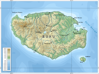
Buru is the third largest island within the Maluku Islands of Indonesia. It lies between the Banda Sea to the south and Seram Sea to the north, west of Ambon and Seram islands. The island belongs to Maluku province and includes the Buru and South Buru regencies. Their administrative centers, Namlea and Namrole, respectively, have ports and are the largest towns of the island, served by Namlea Airport and Namrole Airport respectively.
ETI may refer to:
Most visitors to Indonesia may obtain a visa on arrival to Indonesia, unless they are a citizen of one of the visa-exempt countries.
However, some countries must obtain a visa in advance from one of the Indonesian diplomatic missions before being allowed to enter Indonesia.
All visitors must hold a passport valid for 6 months as well as a valid return ticket.
Passport with validity of more than 3 months can be accepted in special cases or business travel.
The immigration officer at the port of entry may ask the passenger to produce any necessary documents.
Kawa may refer to:

Manusela National Park is located on Seram island, in the Maluku archipelago of Indonesia. It is made up of coastal forest, swamp forest, lowland and montane rainforest ecosystem types. Mount Binaiya at 3,027 meters, is the highest of the park's six mountains. Seram is remarkable for its high degree of localised bird endemism. The park also includes important karst landscapes. On Mount Hatu Saka, near the coast of Saleman-Sawai, it is the Goa Hatusaka, currently the deepest cave of the whole Indonesia.
Batu Kawa is a suburban area located right next to the 3rd Mile Roundabout in Kuching Division, State of Sarawak in Malaysia. The mukim is administratively under the Padawan Municipal Council. The Pan Borneo Highway passing through the area links Kuching City with Bau, Lundu and Sematan further west. This place is also known to have many hornet nest.
Masiwang River is a river of eastern Seram Island, Maluku province, Indonesia, about 2700 km northeast of the capital Jakarta.
The Kawa River is a river of Seram Island, Maluku province, Indonesia, about 2500 km northeast of the capital Jakarta.
Sapalewa River, also Sapolewa, is a river of Seram Island, Maluku province, Indonesia, about 2400 km northeast of the capital Jakarta.
The Eti River is a river of Seram Island, Maluku province, Indonesia, about 2400 km northeast of the capital Jakarta. It flows into the sea on the southwest side of the island, a few kilometres south of the town of Piru, West Seram Regency.
The Tala River is a river of western Seram Island, Maluku province, Indonesia, about 2400 km northeast of the capital Jakarta.
Taniwel is a village and kecamatan on the northwestern coast of the Indonesian island of Seram.
The Ministry of National Development Planning/National Development Planning Agency is a ministry of the Republic of Indonesia that has the task to oversee government affairs in the field of national development planning to assist the President in organizing state government. The minister is responsible to the President. The Ministry of National Development Planning uses organizational units and resources within the National Development Planning Agency.
The Ministry of Public Works and Housing, is an Indonesian government ministry that is responsible for public works and public housing.
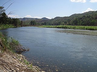
The Waeapo River is a river which flows on the island of Buru, Maluku, Indonesia. It is one of the main rivers of the island, draining towards the Banda Sea in the northeast of the island.
The Sikula River is a river in Ambon Island, Maluku, Indonesia. It primarily flows in the Laha village of Ambon City, and is the longest river within the city's boundaries.
The Wai Apu people are one of the native peoples of Buru island in Maluku, Indonesia, typically inhabiting the north-east of the island in what are now the Namlea and Waplau districts. Research from the Indonesian Ministry of Social Affairs in 1985 numbers the Wai Apu population at approximately 44,048.