Related Research Articles
Atiak is a town in the Northern Region of Uganda on the Gulu-Nimule Road, the primary trade route between Uganda and South Sudan.
Kisozi is a settlement in the Gomba District in the Central Region of Uganda.
The Uganda National Roads Authority (UNRA) is a government agency mandated to develop and maintain the national roads network, advise the government on general roads policy, contribute to the addressing of national transport concerns, and perform certain other functions. UNRA is charged with, among other things, the selection of contractors, the supervision of construction, the scheduling of maintenance, and the prioritization of national road works.
The Mukono–Kyetume–Katosi–Nyenga Road is a road in the Central Region of Uganda, connecting the towns of Mukono, Kyetume and Katosi in Mukono District to Nkokonjeru and Nyenga in Buikwe District.
The Ishaka–Kagamba Road in the Western Region of Uganda connects the town of Kagamba in Ntungamo District with Ishaka in Bushenyi District.
The Acholibur–Gulu–Olwiyo Road is a road in the Northern Region of Uganda, connecting the town of Acholibur to the city of Gulu and the town of Olwiyo.
The Nyakahita–Kazo–Kamwenge–Fort Portal Road is a road in the Western Region of Uganda, connecting the towns of Nyakahita and Kazo in Kiruhura District, Ibanda in Ibanda District, Kamwenge in Kamwenge District, and Fort Portal in Kabarole District.
Kazo is a town in the Western Region of Uganda. It is the capital of Kazo District.
Kigumba–Masindi–Hoima–Kabwoya Road is a road in the Western Region of Uganda, connecting the towns of Kigumba in Kiryandongo District, Masindi in Masindi District, Hoima in Hoima District and Kabwoya, in Kikuube District.
The Kyenjojo–Kabwoya Road, in the Western Region of Uganda, connects the town of Kyenjojo in the Kyenjojo District with Kabwoya in the Hoima District. The road is part of the 238 kilometres (148 mi) Kyenjojo–Hoima–Masindi–Kigumba road corridor.
Mpigi–Kabulasoke–Maddu–Sembabule Road is a road in the Central Region of Uganda, connecting the towns of Mpigi in Mpigi District to Gombe in Butambala District, Kabulasoke and Maddu in Gomba District and Sembabule in Sembabule District.
Musita is a town in Mayuge District, in the Eastern Region of Uganda.
Tororo–Mbale–Soroti Road is a road in Eastern Uganda, connecting the towns of Tororo in Tororo District to Mbale in Mbale District and Soroti in Soroti District.
The Soroti–Dokolo–Lira Road is a road in Uganda, connecting the towns of Soroti in Soroti District, Dokolo in Dokolo District, and Lira in Lira District.
The Ntungamo–Rukungiri Road in the Western Region of Uganda connects the town of Ntungamo in Ntungamo District with Rukungiri in Rukungiri District.
Soroti–Amuria–Abim–Kotido Road is a road in the Eastern and Northern Regions of Uganda. The road connects the towns of Soroti in Soroti District, to Amuria in Amuria District, Abim in Abim District, and Kotido, in Kotido District. Soroti and Amuria lie in the Teso sub-region, while Abim and Kotido are in the Karamoja sub-region.
The Kampala–Mpigi Expressway, also Busega–Mpigi Expressway, is a four-lane, dual carriage highway under construction in the Central Region of Uganda, connecting, Kampala, the capital city, and Mpigi, the headquarters of Mpigi District.
The Kampala–Masaka Road is a road in the Central Region of Uganda, connecting the capital city of Kampala to the southwestern town of Masaka in Masaka District. The first 36 kilometres (22 mi) of this road, is in the process of being developed into the Kampala–Mpigi Expressway.
Kampala–Busunju Expressway is a planned road in the Central Region of Uganda. The road would connect the county's capital city, Kampala, to the town of Busunju in Mityana District.
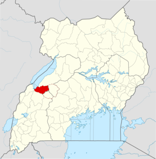
Kagadi District is a district in the Western Region of Uganda.
References
- ↑ UNRA (28 July 2017). "Overview of UNRA". Kampala: Uganda National Roads Authority (UNRA). Retrieved 28 July 2017.
- ↑ Google (1 September 2022). "Road Distance Between Namboole National Stadium, Stadium Round Road, Kampala, Uganda And Busega, Kampala, Uganda" (Map). Google Maps . Google. Retrieved 1 September 2022.
- ↑ Frederic Musisi (6 March 2013). "Northern Bypass upgrade to start next financial year". Daily Monitor . Kampala, Uganda. Retrieved 24 January 2016.
- ↑ Google (1 September 2022). "Road Distance Between Kampala, Uganda And Jinja, Uganda" (Map). Google Maps . Google. Retrieved 1 September 2022.
- ↑ Ojambo, Fred (10 November 2009). "China to Build, Manage Toll Road in Ugandan Capital (Update1)". Bloomberg News . Retrieved 11 July 2015.
- ↑ David Rupiny (21 November 2012). "Museveni Launches Construction of Kampala-Entebbe Expressway". Uganda Radio Network . Kampala, Uganda. Retrieved 18 July 2015.
- ↑ New Vision (15 June 2018). "Entebbe Express Highway Breathes Life". New Vision . Kampala, Uganda. Retrieved 1 September 2022.
- 1 2 Baguma, Raymond (25 November 2008). "Uganda: Gayaza Road Gets Tarmac". New Vision via AllAfrica.com . Kampala. Retrieved 24 January 2016.
- ↑ Mena Report (14 July 2011). "UGANDA: Conclusion of Gayaza-Zirobwe road construction". Highbeam.com. Archived from the original on 29 March 2015. Retrieved 11 July 2015.
- ↑ Frederick Kiwanuka (22 January 2009). "New road to boost Nakaseke agriculture". New Vision . Kampala, Uganda. Retrieved 1 September 2022.
- ↑ Uganda National Roads Authority (17 July 2015). "Kabale-Kisoro-Bunagana Road (100KM)". Uganda National Roads Authority . Kampala, Uganda. Archived from the original on 4 March 2016. Retrieved 17 July 2015.
- ↑ Samuel Balagadde (7 October 2012). "Kabale-Kisoro road upgraded". New Vision . Kampala, Uganda. Retrieved 11 July 2015.
- ↑ Billy Rwothungeyo (24 June 2013). "Fort Portal-Bundibugyo-Lamia road almost complete". New Vision . Kampala, Uganda. Retrieved 11 July 2015.
- ↑ Martin Okudi and Cissy Makumbi (3 March 2013). "Locals protest over dust on Gulu-Nimule highway". Daily Monitor . Kampala, Uganda. Retrieved 24 January 2016.
- ↑ Sudan Tribune (11 May 2012). "Ugandan president commissions Gulu-Juba highway". Sudan Tribune . Paris, France. Retrieved 24 January 2016.
- ↑ Aidah Nanyonjo (26 May 2010). "Mbarara gets sh459b bypass". New Vision . Kampala, Uganda. Retrieved 24 January 2016.
- ↑ Joshua Nahamya (1 March 2015). "Mbarara Bypass Construction Underway". Chimpreports.com. Kampala, Uganda. Retrieved 11 July 2015.
- ↑ Francis Mugerwa (2 July 2013). "Oil opens new chapter for Hoima residents". Daily Monitor . Kampala, Uganda. Retrieved 11 July 2015.
- ↑ New Vision (11 August 2011). "Hoima-Kaiso Tonya road works start". New Vision . Kampala, Uganda. Retrieved 24 January 2016.
- ↑ Oil In Uganda (17 December 2014). "Hoima-Kaiso Tonya road completed". Oilinuganda.org. Retrieved 11 July 2015.
- ↑ Alinange, Daniel (20 January 2015). "Press Release: CONSTITUTIONAL COURT DISMISSES EUTAW/APOLO SENKEETO APPLICATION TO STOP MUKONO-KYETUME –KATOSI ROAD PROJECT". Uganda National Roads Authority (UNRA) via Facebook.com . Retrieved 10 July 2015.
- ↑ Yoweri Museveni Facebook Page (7 July 2014). "President Museveni commissions Ugshs 165 bn Mukono-Katosi/Kisoga-Nyenga road works, calls on Ugandans to concentrate on household incomes, July 7th 2014". Facebook.com . Retrieved 11 July 2015.
{{cite web}}:|last=has generic name (help) - ↑ Uganda State House (7 July 2014). "President commissions Shs 165 billion Mukono-Katosi road works, tells Ugandans to concentrate on household income". Uganda State House Website. Retrieved 11 July 2015.
- ↑ Batre, Ronald (19 December 2014). "UNRA fails to Beat December Deadline for Vurra-Arua-Koboko-Oraba Road". Uganda Radio Network. Retrieved 11 July 2015.
- ↑ USHMU (11 May 2012). "Use the road for making wealth – President urges West Nile people". Uganda State House Media Unit (USHMU). Retrieved 10 July 2015.
- ↑ UNRA. "ongoing major projects". Uganda National Roads Authority (UNRA). Retrieved 11 July 2015.
- ↑ Rwothungeyo, Billy (2 January 2015). "Hoima-Butiaba-Wanseko road for upgrade". New Vision . Kampala. Retrieved 11 July 2015.
- ↑ Kasaija, Matia (11 June 2015). "Full Budget Speech 2015/2016". NTV Uganda. Retrieved 11 July 2015.
- ↑ Wanyama, Olandason (12 November 2013). "Moroto - Nakapiripirit Road Construction Commissioned". Uganda Radio Network. Retrieved 11 July 2015.
- ↑ GFC (11 July 2015). "Travel Distance Between Mbarara And Kikagati With Interactive Map". Globefeed.com (GFC). Retrieved 11 July 2015.
- ↑ UMWT (11 July 2015). "Upgrade of Mbarara – Kikagati – Murongo Bridge (74 Km)". Uganda Ministry of Works & Transport (UMWT). Archived from the original on 12 July 2015. Retrieved 11 July 2015.
- ↑ Administrator (2 October 2014). "Mbarara-Kikagati-Murongo Bridge Road Completed". Chimpreports.com. Retrieved 11 July 2015.
- ↑ Mugera, Isaac (16 May 2008). "Hundreds Stranded On Blocked Masaka–Bukakata Road". Uganda Radio Network. Retrieved 11 July 2015.
- ↑ Rwothungeyo, Billy (29 June 2014). "Solicitor General clears contracts for 450km of roads". New Vision . Kampala. Retrieved 11 July 2015.
- ↑ Oirere, Shem (September 2014). "Two new road links will help boost Uganda's economy". Worldhighways.com. Retrieved 12 July 2015.
- ↑ Google (12 July 2015). "Location of Ishaka–Kagamba Road at Google Maps" (Map). Google Maps . Google. Retrieved 12 July 2015.
- ↑ UNRA (30 June 2012). "ISHAKA-KAGAMBA ROAD (35.4KM)". Uganda National Roads Authority (UNRA). Retrieved 12 July 2015.
- ↑ UNRA (31 March 2015). "Uganda National Roads Authority: Update of Ongoing Major Projects" (PDF). Uganda National Roads Authority (UNRA). Retrieved 12 July 2015.
- ↑ Alfred Tumushabe, and Perez Rumanzi (8 October 2015). "Museveni commissions Ntungamo-Mirama road". Daily Monitor . Kampala. Retrieved 14 July 2015.
- ↑ TMEA (6 October 2014). "Ntungamo-Mirama Hills Ground Breaking road ceremony expected to boost cross border trade between Uganda and Rwanda". TradeMark East Africa (TMEA). Retrieved 14 July 2015.
- ↑ ADB (July 2009). "African Development Fund: Uganda - Road Sector Support Project 3: Project Appraisal Report" (PDF). African Development Bank (ADB). Retrieved 15 July 2015.
- ↑ UNRA (28 July 2009). "Road Sector Support Project (Phase III) In Uganda: Feasibility Study And Detailed Engineering Design". Devex.com. Retrieved 15 July 2015.
- 1 2 Administrator (4 November 2014). "UNRA to begin works on 16 roads next year". Kampala: Sunrise.ug. Retrieved 15 July 2015.
- ↑ Robert Ndyabarema; et al. (November 2013). "Bumbobi-Bubulo-Lwakhakha Road: Environment And Social Impact Statement (ESIS) - Updated Final Report November 2013" (PDF). African Development Bank . Retrieved 15 July 2015.
- 1 2 AICPI (April 2013). "Feasibility Study, Detailed Engineering Design, Tender Assistance And Project Management for The Upgrading to Bituminous Standards of Lot A: (i) Rwenkunye-Apac-Lira-Kitgum-Musingo (350 km) And (ii) Olwiyo-Gulu-Kitgum (167 km)". Aicprogetti.it (AICPI). Retrieved 16 July 2015.
- 1 2 3 4 Komakech, Dan Michael (23 February 2015). "Museveni launches road works". Daily Monitor . Kampala. Retrieved 15 July 2015.
- ↑ Nanyonjo A., Balagadde S. (1 September 2010). "Four firms bid for Kamwenge road works". New Vision . Kampala. Retrieved 24 January 2016.
- ↑ Press Release (27 February 2015). "President Launches Construction of Kamwenge–Fort Portal Road". Uganda Media Centre. Retrieved 25 July 2015.
- ↑ EAAB (January 2015). "IMPLEMENTATION OF THE NRM – MANIFESTO 2011-2016". East Africa Agribusiness (EAAB). Archived from the original on 15 July 2015. Retrieved 25 July 2015.
- ↑ GFC (4 August 2015). "Map Showing Mpigi And Sembabule With Route Marker". Globefeed.com (GFC). Retrieved 4 August 2015.
- 1 2 EAAB (12 July 2015). "Implementation of the NRM Manifesto 2011-2016: Mpigi–Kabulasoke–Maddu–Sembabule Road And Sembale–Villa Maria Road". East Africa Agribusiness (EAAB). Archived from the original on 15 July 2015. Retrieved 4 August 2015.
- ↑ ADB (May 2013). "Upgrading of Kigumba–Masindi–Hoima–Kabwoya Road (135Km): General Procurement Notice" (PDF). African Development Bank (ADB). Retrieved 4 August 2015.
- ↑ Rwothungeyo, Billy (10 June 2013). "Kigumba-Masindi-Hoima road to be upgraded to tarmac". New Vision . Kampala. Retrieved 25 August 2015.
- ↑ EAAB (March 2015). "UNRA PAVES 1200KM ROADS; 5,000KM FOR TARMACKING BY 2016". East African Agribusiness (EAAB). Archived from the original on 12 July 2015. Retrieved 4 August 2015.
- 1 2 The Insider Reporter (23 February 2015). "Enthusiasm as Mayuge welcomes Museveni". The Insider (Uganda). Archived from the original on 23 July 2015. Retrieved 4 August 2015.
- ↑ Kasooha, Ismael (23 September 2010). "Govt to tarmac Mubende-Kakumiro road". New Vision . Kampala. Retrieved 25 August 2015.[ dead link ]
- ↑ Mugerwa, Francis (4 May 2015). "Kagina will rid UNRA of den of thieves, says Museveni". Daily Monitor . Kampala. Retrieved 25 August 2015.
- ↑ UNRA (14 January 2013). "Specific Procurement Notice: Upgrading of Kyenjojo-Kabwoya Road (100km) from Gravel to Paved (Bituminous) Standard" (PDF). Kampala: Uganda National Roads Authority (UNRA). Retrieved 25 August 2015.
- ↑ Namutebi, Joyce (7 January 2014). "Govt seeks sh290b loan from World Bank". New Vision . Kampala. Retrieved 25 August 2015.
- ↑ GFC (25 August 2015). "Map Showing Ziroobwe And Wobulenzi With Route Marker". Globefeed.com (GFC). Retrieved 25 August 2015.
- 1 2 Sekanjako, Henry (25 July 2012). "Delayed Tororo-Mbale-Soroti road to cost more money". New Vision . Kampala. Retrieved 29 August 2015.
- ↑ GFC (29 August 2015). "Road Distance Between Tororo And Soroti With Map". Globefeed.com (GFC). Retrieved 29 August 2015.
- ↑ Newvision (29 August 2015). "Infrastructure devt will solve youth unemployment – President". New Vision . Kampala. Retrieved 29 August 2015.
- 1 2 Faridah Kulabako., and John Njoroge (30 December 2010). "Mbarara-Katuna road Gets Shs325b". Daily Monitor . Kampala. Retrieved 17 December 2015.
- ↑ Maseruka, Josephine (2 January 2012). "Corruption cited In Mbarara-Katuna road reconstruction". New Vision . Kampala. Retrieved 17 December 2015.
- ↑ GFC (17 December 2015). "Road Distance Between Soroti And Lira With Interactive Map". Globefeed.com (GFC). Retrieved 17 December 2015.
- ↑ Kiwawulo, Chris (29 March 2007). "Soroti-Lira Road Works for May". New Vision . Kampala. Archived from the original on 22 December 2015. Retrieved 17 December 2015.
- ↑ Nankya, Vivian (7 June 2009). "Soroti-Lira road to be ready on time". New Vision . Kampala. Archived from the original on 30 June 2015. Retrieved 17 December 2015.
- ↑ UNRA (2010). "Soroti–Dokolo–Lira Road (123 Km)". Uganda National Roads Authority (UNRA). Retrieved 17 December 2015.
- ↑ Murumba, Stellar (31 December 2015). "Kenya, Uganda seek transport corridor funds with eye on trade". The EastAfrican . Nairobi. Retrieved 31 December 2015.
- ↑ GFC. "Road Distance Between Kapchorwa And Suam With Route Marker". Globefeed.com (GFC). Retrieved 31 December 2015.
- ↑ Stellar Murumba, and Mark Keith Muhumuza (1 January 2016). "Uganda seeks Shs270b for Kapchorwa-Suam road to boost regional trade". Daily Monitor . Kampala. Retrieved 1 January 2016.
- ↑ Nakatudde, Olive (11 March 2015). "Parliament Okays Shs330billion Loan for Nakapiripirit Road". Kampala: Uganda Radio Network. Retrieved 21 January 2016.
- ↑ IDB (6 December 2015). "Tenders Opportunities for Projects Financed by IDB: Tender Title: SPN - CIVIL WORKS FOR THE UPGRADING OF 92KM MUYEMBE – NAKAPIRIPIRIT ROAD AND 25KM SECONDARY LINK ROADS". Jeddah, Saudi Arabia: Islamic Development Bank . Retrieved 8 January 2016.
- ↑ Kiirya, Donald (17 February 2012). "Jinja residents riot over road". www.crossroads.co.ug quoting New Vision . Kampala. Archived from the original on 27 January 2016. Retrieved 21 January 2016.
- ↑ Vision Reporter (4 March 2015). "What is NRM's better service delivery in practice?". New Vision . Kampala. Retrieved 10 January 2016.
- ↑ NTV (7 June 2015). "Road Expansion: Mukono, Kayunga residents to be compensated". Kampala: Facebook.com Quoting Nation TV Uganda (NTV). Retrieved 11 January 2016.
- ↑ Kezaabu, Carol (30 December 2014). "The following roads will commence in 2015". Uganda National Roads Authority. Retrieved 21 January 2016– via Facebook.
- 1 2 UNRA (19 January 2016). "Upcoming Projects: New Roads for Upgrade to Tarmac". Kampala: Uganda National Roads Authority (UNRA). Archived from the original on 20 January 2016. Retrieved 19 January 2016.
- ↑ Vision Reporter (30 January 2001). "Firms Bid For Rukungiri Road". New Vision . Kampala. Retrieved 24 January 2016.
- ↑ GFC (24 January 2016). "Distance between Ntungamo, Western Region, Uganda and Rukungiri Court, Rukungiri, Western Region, Uganda". Globefeed.com (GFC). Retrieved 24 January 2016.
- 1 2 Alfred Tumushabe, and Perez Rumanzi (13 November 2015). "Uganda: Besigye Condemns Museveni On Roads". Daily Monitor via AllAfrica.com . Kampala. Retrieved 24 January 2016.
- ↑ Vision Reporter (22 September 2011). "Motorists angry over Kotido road". New Vision . Kampala. Retrieved 11 February 2016.
- ↑ GFC (11 February 2016). "Distance between Soroti, Eastern Region, Uganda and Kotido, Northern Region, Uganda". Globefeed.com (GFC). Retrieved 11 February 2016.
- ↑ Musisi, Frederic (30 December 2016). "Kampala-Mpigi Expressway project kicks off in 2018". Daily Monitor . Kampala. Retrieved 28 July 2017.
- ↑ Google (1 September 2022). "Road Distance Between Kampala Road Post Oice, Kampala, Uganda And Mpigi Post Office, Mpigi, Uganda" (Map). Google Maps . Google. Retrieved 1 September 2022.
- ↑ Wanyenya, Prisca (9 May 2014). "UNRA Announces Changes on Kampala-Entebbe Express Highway". The Red Pepper Newspaper . Kampala. Retrieved 11 February 2016.
- ↑ Global Data (13 July 2018). "UNRA – Lusalira to Ssembabule Road Upgrade – Uganda". Globaldata.com. London, United Kingdom. Retrieved 1 September 2022.
- ↑ Ismail Musa Ladu (28 February 2022). "All oil roads will be ready by 2025, says Kagina". Daily Monitor . Kampala, Uganda. Retrieved 1 September 2022.
- ↑ Hafitha Issa (9 June 2019). "Gov't to Tarmac Mpigi-Kasanje-Nakawuka Road". Uganda Radio Network . Kampala, Uganda. Retrieved 3 September 2022.
- ↑ Kenneth Kazibwe (10 August 2021). "Museveni directs UNRA to award six road projects to Chinese companies". Nile Post Uganda. Kampala, Uganda. Retrieved 3 September 2022.
- ↑ Apollo Mubiru (1 May 2024). "Parliament Approves Sh450 Billion Loan For Kitgum-Kidepo Road". New Vision . Kampala, Uganda. Retrieved 19 May 2024.