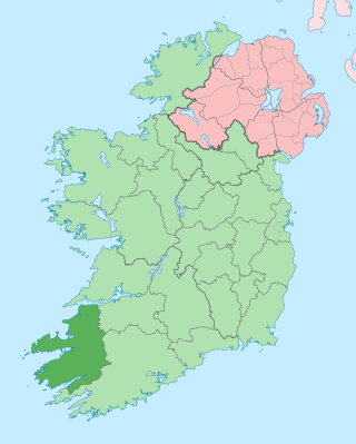
County Kerry is a county in Ireland. It is in the Southern Region and the province of Munster. It is named after the Ciarraige who lived in part of the present county. The population of the county was 156,458 at the 2022 census.

Tralee is the county town of County Kerry in the south-west of Ireland. The town is on the northern side of the neck of the Dingle Peninsula, and is the largest town in County Kerry. The town's population was 26,079 as of the 2022 census, making it the 15th largest urban settlement in Ireland. Tralee is known for the Rose of Tralee International Festival, which has been held annually in August since 1959.

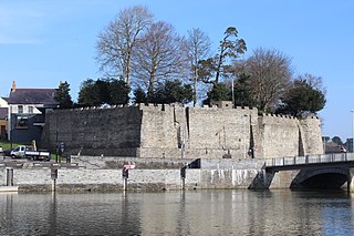
Ardfert is a village and civil parish in County Kerry, Ireland. Historically a religious centre, the economy of the locality is driven by agriculture and its position as a dormitory town, being only 8 km (5 mi) from Tralee. The population of the village was 749 at the 2016 census.
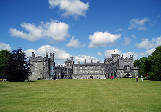
Kilkenny Castle is a castle in Kilkenny, Ireland, built in 1260 to control a fording-point of the River Nore and the junction of several routeways. It was a symbol of Norman occupation, and in its original 13th-century condition, it would have formed an important element of the town's defences with four large circular corner towers and a massive ditch, part of which can still be seen today on the Parade.

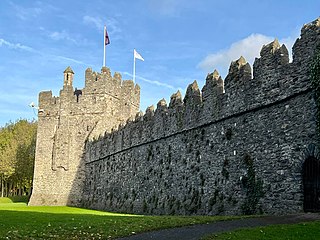
Bunratty Castle is a large 15th-century tower house in County Clare, Ireland. It is located in the centre of Bunratty village, by the N18 road between Limerick and Ennis, near Shannon Town and its airport. The castle and the adjoining folk park are run by Shannon Heritage as tourist attractions.

Listowel is a heritage market town in County Kerry, Ireland. It is on the River Feale, 28 km (17 mi) from the county town, Tralee. The town of Listowel had a population of 4,794 according to the 2022 census, the third largest in the county. Listowel is also the name of a townland within the town and an encompassing civil parish.
Ballybunion or Ballybunnion is a coastal town and seaside resort in County Kerry, Ireland, on the Wild Atlantic Way, 15 km (9 mi) from the town of Listowel. As of the 2022 census, Ballybunion had a population of 1,618.

Kilflynn is a village and a civil parish in north County Kerry, Ireland. It is 11 km north-east of Tralee just off the N69 road from Tralee to Listowel.
The architecture of Ireland is one of the most visible features in the Irish countryside – with remains from all eras since the Stone Age abounding. Ireland is famous for its ruined and intact Norman and Anglo-Irish castles, small whitewashed thatched cottages and Georgian urban buildings. What are unaccountably somewhat less famous are the still complete Palladian and Rococo country houses which can be favourably compared to anything similar in northern Europe, and the country's many Gothic and neo-Gothic cathedrals and buildings.

Stranorlar is a town, townland and civil parish in the Finn Valley of County Donegal, in Ireland. Stranorlar and Ballybofey form the Twin Towns.
Cardigan Castle is a castle overlooking the River Teifi in Cardigan, Ceredigion, Wales. It is a Grade I listed building. The castle dates from the late 11th-century, though was rebuilt in 1244. Castle Green House was built inside the castle walls in the early 1800s. After falling into disrepair the castle was restored in the early 2000s and opened to the public in 2015. It is owned by Ceredigion County Council and now includes a heritage centre and open-air concert facilities. The castle's gardens are listed on the Cadw/ICOMOS Register of Parks and Gardens of Special Historic Interest in Wales.
Swords Castle is an early medieval castle located in Swords, Dublin. Originally built for the Archbishops of Dublin in the early 13th century near the Ward River, some of the castle estate had fallen into disrepair by the 14th and 15th centuries. At least partially occupied through the 16th and 17th centuries, the castle was used as a place of rendezvous by Anglo-Irish Catholic families during the 1641 Rebellion. The site was afforded protection as a national monument and placed under the guardianship of the Office of Public Works in the early 20th century. As of the late 20th and early 21st century, the site was subject to a program of "long-term phased restoration", and is partially opened for tours. The site is listed on Fingal County Council's Record of Protected Structures.

Ballylongford is a village near Listowel in northern County Kerry, Ireland.

Clare Castle is a high-mounted ruinous medieval castle in the parish and former manor of Clare in Suffolk, England, anciently the caput of a feudal barony. It was built shortly after the Norman Conquest of England in 1066 by Richard Fitz Gilbert, having high motte and bailey and later improved in stone. In the 14th century it was the seat of Elizabeth de Clare, one of the wealthiest women in England, who maintained a substantial household there. The castle passed into the hands of the Crown and by 1600 was disused. The ruins are an unusually tall earthen motte surmounted by tall remnants of a wall and of the round tower, with large grassland or near-rubble gaps on several of their sides. It was damaged by an alternate line of the Great Eastern Railway in 1867, the rails of which have been removed.

Bunratty is a village in County Clare, Ireland, near Bunratty Castle. It is connected by the N18 road to Limerick and Galway. The Raite river defines the parish's eastern boundary and flows into the Shannon Estuary, which defines the southern boundary.
Quin is a village in southeast County Clare, Ireland. The name also refers to a civil parish in the barony of Bunratty Upper, and to an ecclesiastical parish of the same name. The main attraction in the vicinity is Quin Abbey, the ruins of Franciscan friary, which is open to the public. Although roofless, much of the structure remains and is relatively well-preserved. The abbey was built on the foundations of an earlier Norman castle; the foundations of three corner towers can still be seen.

Thoor Ballylee Castle is a fortified, 15th-century Anglo-Norman tower house built by the septs de Burgo, or Burke, near the town of Gort in County Galway, Ireland. It is also known as Yeats' Tower because it was once owned and inhabited by the poet William Butler Yeats.

Roscrea Castle is a 13th-century motte-and-bailey castle in the town of Roscrea, Ireland. The Castle consists of a walled courtyard, gate block, and angled towers. Along with 18th century Damer House and gardens, the Castle forms part of Roscrea Heritage Centre.
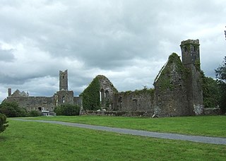
An Teampall Bán more commonly known by its diminutive name Teampaillin Bán is a famine graveyard located off the Ballybunion road in Listowel, County Kerry. It is the burial ground of over 2,641 victims who died between February 1850 and March 1852 during the Great Famine.