Harmony is a small unincorporated community in Caroline County, Maryland, United States. It is little more than an intersection of state Routes 16 and 578 on Maryland's Eastern Shore. Its original name was Fowling Creek named after a stream nearby that is a tributary of the Choptank River.
Fishing Creek may refer to a location in the United States:

The Choptank River is a major tributary of the Chesapeake Bay and the largest river on the Delmarva Peninsula. Running for 71 miles (114 km), it rises in Kent County, Delaware, runs through Caroline County, Maryland and forms much of the border between Talbot County, Maryland on the north, and Caroline County and Dorchester County on the east and south. It is located north of the Nanticoke River and its mouth is located south of Eastern Bay. Cambridge, the county seat of Dorchester County, and Denton, the county seat of Caroline County, are located on its south shore.

Choptank is an unincorporated town and census-designated place on the Eastern Shore of Maryland, in Caroline County, Maryland, United States. As of the 2010 census it had a population of 129.
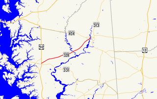
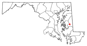
Maryland Route 328 is a state highway in the U.S. state of Maryland. The state highway runs 15.24 mi (24.53 km) from U.S. Route 50 in Easton east to just north of MD 404 in West Denton. MD 328 connects Easton with Denton, passing through eastern Talbot County and a neck of land in Caroline County between the Choptank River and Tuckahoe Creek. MD 328 was constructed in Talbot County in the late 1910s between downtown Easton and a point west of Matthews. The state highway was constructed in Caroline County in the late 1920s and early 1930s, and was originally designated MD 457. The gap between the two highways was filled in the late 1940s and included a modern bridge over Tuckahoe Creek. MD 328's western terminus was moved to US 50 in the early 1960s. In West Denton, the highway was relocated and extended north to present MD 404 in the early 1980s.

Maryland Route 343 is a state highway in the U.S. state of Maryland. Known for most of its length as Hudson Road, the state highway runs 11.29 miles (18.17 km) from Hudson in northwestern Dorchester County east to U.S. Route 50 in Cambridge. MD 343 was paved in the late 1920s and early 1930s. The state highway originally passed through downtown Cambridge, ending just west of its present terminus. After the original Choptank River Bridge was completed in the mid-1930s, MD 343 was truncated to Sunburst Highway. In the mid-1950s, the state highway was rerouted along Washington Street to Race Street, where it ended at MD 16. Finally, MD 343 was extended to its present terminus when MD 16 bypassed Cambridge in the late 1960s.

The Choptank River Light was a screw-pile lighthouse located near Oxford, Maryland. In its second incarnation it was the only such light moved from another location in the Chesapeake Bay.
Slaughter Creek is a 6.7-mile-long (10.8 km) saltwater creek that drains into the Little Choptank River. The creek is 0.3 miles (0.5 km) wide at its mouth. It separates Taylors Island, Maryland from the mainland.
Tuckahoe Creek is a 21.5-mile-long (34.6 km) tributary of the Choptank River on Maryland's Eastern Shore. It is sometimes (erroneously) referred to as the Tuckahoe River. Upstream of Hillsboro, it forms the boundary between Caroline County and Queen Anne's County, passing through Tuckahoe State Park and dividing the small towns of Queen Anne and Hillsboro. Downstream of Hillsboro, it forms the boundary between Caroline County and Talbot County, before flowing into the Choptank.
Bill Burton Fishing Pier State Park is a public recreation area on the Choptank River in Trappe, Maryland. The state park preserves portions of the former Choptank River Bridge as a pier, and includes 25 acres (10 ha) of land upriver from the pier in Talbot County.
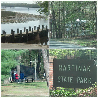
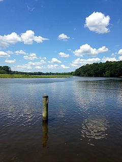
Martinak State Park is a public recreation area located on the Choptank River and Watts Creek, immediately south of Denton in Caroline County, Maryland. The park bears the name of George Martinak, who deeded his land to the state in 1961. The park opened in 1964. Site improvements including the addition of campsites, roads, and park office took place from 1964 to 1974. The park features boating access, fishing, campsites and cabins, hiking trails, and nature center.

The Tred Avon River is a main tributary of the Choptank River in Talbot County on Maryland's Eastern Shore. The river is 17 miles (27 km) long.
West Denton is an unincorporated community and census-designated place (CDP) in Caroline County, Maryland, United States. As of the 2010 census it had a population of 52.
The Choptank were an Algonquian-speaking Native American people that historically lived on the Eastern Shore of Maryland on the Delmarva Peninsula. They occupied an area along the lower Choptank River basin, which included parts of present-day Talbot, Dorchester and Caroline counties. The river emptied into the Chesapeake Bay. They spoke Nanticoke, an Eastern Algonquian language closely related to Delaware.
The Eastern Shore Hospital Center is a 76-bed psychiatric facility that is located in Cambridge, Maryland. It is owned and operated by the State of Maryland, under the Maryland Department of Health and Mental Hygiene. Levels of care provided include acute and long-term inpatient psychiatric hospital services for adults aged 18 and older. The Center also operates an on-site 16-bed residential Assisted Living Program that is known as Stepping Stone at Manokin. The 40-bed Upper Shore Community Mental Health Center, a psychiatric hospital that was located in Chestertown, and the Eastern Shore Hospital Center were jointly administered for a number of years. The Upper Shore Community Mental Health Center was closed in March 2010.
Town Creek is a tributary of the Tred Avon River in Talbot County on Maryland's Eastern Shore.
Harris Creek (Maryland) is a tidal creek on the eastern shore of Maryland. It is a location for oyster restoration.
King's Creek is a stream in Talbot County, Maryland, running for about 6 miles (9.7 km). It flows into the Choptank River and thence into Chesapeake Bay.

