External links
Coordinates: 39°25′08″N76°32′07″W / 39.41889°N 76.53528°W
Loch Raven is a neighborhood extending from northeast Baltimore City to the eastern part of Baltimore County, Maryland. The major road in the neighborhood is Loch Raven Boulevard, which stretches all the way from the I-695 beltway in Baltimore County to 25th Street in Baltimore City. It is located in the Baltimore Metro Area, and is considered one of the longest roads in the area with many different aspects of Baltimore that can be seen by riding through the area. This region is a diverse, but predominantly African American part of the city and county, and is also the area that consists of a large amount of Morgan State University students. The zip codes assigned to this area are 21218, 21239, 21286, 21284, and 21234, which is also a Parkville zip code.
Coordinates: 39°25′08″N76°32′07″W / 39.41889°N 76.53528°W

Pasadena is a census-designated place (CDP) in Anne Arundel County, Maryland, United States. The population was 24,287 at the 2010 census.
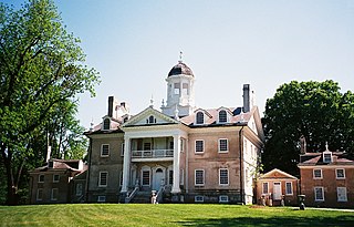
Hampton is an unincorporated community and census-designated place (CDP) in Baltimore County, Maryland, United States. The population was 5,052 at the 2010 census. Hampton is often considered a subdivision of the nearby community of Towson and is located just north of Baltimore, about twenty minutes from downtown. Hampton contains residences situated on lots up to several acres in a park-like setting. The community is anchored by its principal landmark, the Hampton National Historic Site. The Towson United Methodist Church is located in Hampton, flanked on the south by I-695 and Goucher College.

Parkville is an unincorporated community and census-designated place in Baltimore County, Maryland, United States. As of the 2010 census, the population was 30,734.

Towson is an unincorporated community and a census-designated place in Baltimore County, Maryland, United States. The population was 55,197 as of the 2010 census. It is the county seat of Baltimore County and the second-most populous unincorporated county seat in the United States.

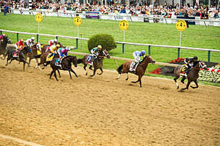
Timonium is a census-designated place (CDP) in Baltimore County, Maryland, United States. As of the 2010 census it had a population of 9,926. Prior to 2010 the area was part of the Lutherville-Timonium CDP. The Maryland State Fair is held in Timonium each year near Labor Day on the grounds of the former Timonium Race Course, which is an important site along with Pimlico Race Course in northwest Baltimore and Laurel Park in Prince George's County, along with other former tracks at Bowie and Rosecroft in Maryland thoroughbred horse racing traditions.

Mondawmin is a neighborhood located in the city of Baltimore, Maryland, United States. The neighborhood is surrounded by Druid Hill Park, the Whitelock Community, and Lower Park Heights. Included within its boundaries are Frederick Douglass High School, and Mondawmin Mall. The Baltimore Metro Subway serves the neighborhood, with a station at Mondawmin Mall that is also a hub for many bus routes.
Pimlico, a neighborhood in Baltimore, Maryland, is the site of Pimlico Race Course, which holds the Preakness Stakes, one of the three legs of the Triple Crown of Thoroughbred Racing. From 1896 through 1915, Pimlico was also the home of Baltimore's Electric Park, a popular amusement park located near the intersection of Reisterstown Road and Belvedere Avenue.

Hamilton Hills is a mixed-use suburban neighborhood located in the northeastern corner of Baltimore City, Maryland. Hamilton Hills represents a section of Hamilton, a larger historic area that includes other neighborhoods in Northeast Baltimore. The neighborhood's borders are Old Harford Road and Harford Road to the east, Echodale Avenue to the south, Perring Parkway to the west and the Baltimore County line to the north. The main thoroughfare in Hamilton Hills is Harford Road, which has been an integral part of the area's history.

Otterbein is a small neighborhood of historic rowhouses in Baltimore, Maryland, United States. Otterbein is immediately southwest of, and in close walking distance to, the Inner Harbor. The neighborhood is very compact, entirely located between Hanover Street and Sharp Street, and between Barre Street and Henrietta Street. It is in small parts of zip codes 21201 and 21230. It is named for Old Otterbein Church, located immediately north of the neighborhood.

Ellwood Park is a neighborhood in the eastern part of Baltimore, Maryland. It is named for a small public park with a playground between Jefferson and Orleans Streets. The neighborhood extends from Linwood Avenue and Haven Street, between Monument Street and Fayette Street. It is contained within the 21205 and 21224 zip code.
Northern Parkway is a major road that runs west–east across the northern part of the city Baltimore. For most of the way, it is at least six lanes wide, and it is used by motorists for crosstown travel. It is designated E. Northern Pkwy and W. Northern Pkwy with Charles Street being the dividing line. It was constructed in the 1950s through several neighborhoods and several homes were razed in the process from right-of-way. The section of E. Northern Pkwy from Harford Road to Fleetwood Ave was originally called German Lane.
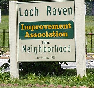
Loch Raven is a neighborhood in the Northeastern part of Baltimore, Maryland. It is located in the Upper Northwood Section of Northeast Baltimore east of Loch Raven Boulevard, west of Mount Pleasant Park, and borders the Baltimore City/County Line and served by the Loch Raven Improvement Association.

Parkville High School (PHS) is a four-year public high school in Baltimore County, Maryland, United States. The school was originally established in 1953 on what is now the location of Parkville Middle School. The current high school building opened in 1961. Area middle schools include Parkville Middle, Loch Raven Academy, and Pine Grove Middle.
Dayton is an unincorporated community located in Howard County, Maryland, United States.

Woodberry is a neighborhood located in the north-central area of Baltimore, Maryland, USA. A largely residential, middle-class area, Woodberry is a historic community bordered on the north by Cold Spring Lane, on the south by Druid Hill Park, on the west by Greenspring Avenue, and on the east by the Jones Falls Expressway and the Jones Falls. Woodberry is located within Postal Zip code 21211.

Brooklyn is one of the southernmost neighborhoods in Baltimore, Maryland. It is located near Anne Arundel County along Governor Ritchie Highway which is also Maryland Route 2. Its main roads are South Hanover Street,, Potee Street, and East Patapsco Avenue, Sixth Street, Tenth Street, and West Bay Avenue which borders the neighboring Curtis Bay community to the east, running through Bay Brook Park, which separates the two. South Hanover Street also serves as the dividing line between east–west streets in Brooklyn, as Charles Street does not exist here. Often mistaken as Brooklyn Park, Brooklyn shares the 21225 ZIP Code with the greater Brooklyn Park area which is across the Baltimore City Line in and the other neighboring community of Cherry Hill to the west and northwest across the now small western branch of the Patapsco River flowing from Ellicott City and Elkridge and along the shoreline-hugging southern extension "South Hanover Street" of the downtown's old colonial-era "Hanover Street" across the 1914-1917 Hanover Street Bridge, later renamed the Vietnam Veterans Memorial Bridge in the 1990s.
Ramblewood is a small community located in northeast Baltimore, Maryland, United States. Ramblewood is located south of Northern Parkway with The Alameda serving as its western boundary and Loch Raven Blvd. as its eastern boundary and north of Belvedere Ave. The Ramblewood Community Association has had residential parking permits issued to its members as the result of the proliferation of students from Morgan parking in the neighborhood.

Evergreen is a neighborhood in the North District of Baltimore, Maryland. Evergreen's buildings date from the late 19th to early 20th century. It is known as one of the first early non-rowhouse styled suburban communities in Baltimore.

Forest Hill is an unincorporated community in Harford County, Maryland, United States, located north of the county seat of Bel Air. The main part of town is located at the intersection of Maryland Route 24 and Jarrettsville Road. Until 1958, this community was served by the Maryland and Pennsylvania Railroad at milepost 30.3.
Perring-Loch is a small community located in northeast Baltimore, Maryland, United States. Perring Parkway serves as its eastern border and Loch Raven Boulevard as its western border; hence the name Perring-Loch. Woodbourne Avenue and Hartsdale Road are the northern and southern boundaries respectively. The entire community is with the 21239 postal zip code and is served by the Perring Loch community association.
