London Protocol (1944)

Last updated

In the London Protocol signed on 12 September 1944, the Allies of World War II (then without France) agreed on dividing Germany into three occupation zones after the war. [1]

Contents

History

The 1st EAC Zone Protocol

EAC planning of occupation zone borders in Germany, 1944 EAC Zonenprotokoll 1.png
EAC planning of occupation zone borders in Germany, 1944

The first zone protocol was drawn up at the meeting of the European Advisory Commission (EAC) on 12 September 1944 and signed by John Gilbert Winant (USA), William Strang (UK) and Fedor Gusev (USSR) at Lancaster House in London, [2] and described the first notions of the boundary between the one to be created: Eastern, Northwestern, and Southwestern.

The zones in Germany and the three parts of the area of Greater Berlin to be created. The basis of the ideas are the borders of Germany from 31 December 1937 (de) and Greater Berlin from 27 April 1920.

The north-western and south-western zones in Germany and Greater Berlin have not yet been assigned as British or American sub-areas. The relevant text passages provided for this are only documented with spaces, whereas the eastern zone and the north-eastern zone of Greater Berlin are already marked directly with "USSR".

In terms of borders, the western borders of Thuringia, Anhalt and the Prussian province of Saxony are referred to. This means that the areas east of the Werra and west of the Elbe were not - as was often published - "exchanged for West Berlin", but the areas in the west of the Elbe were already intended to be part of the Eastern Zone.

Original text:

Eastern Zone: The territory of Germany (including the province of East Prussia) situated to the East of a line drawn from the point on Lübeck Bay where the frontiers of Schleswig-Holstein and Mecklenburg meet, along the western frontier of Mecklenburg to the frontier of the province of Hanover, thence, along the eastern frontier of Braunschweig; thence along the western frontier of Anhalt; the western frontier of the Prussian province of Saxony and the western frontier of Thuringia to where the latter meets the Bavarian frontier; then eastwards along the northern frontier of Bavaria to the 1937 Czechoslovakian frontier, will be occupied by the armed forces of the USSR, with the exception of the Berlin area, for which a special system of occupation is provided below.

The Soviet zone was supposed to encompass the eastern part of Germany, including the explicitly mentioned East Prussia, and no cession of areas to Poland was planned.

The border between the two western zones (and here not yet assigned to any occupying power) was defined as follows:

Northwestern Zone: The territory of Germany situated to the west of the defined above, and bounded on the south by a line drawn from the point where the western frontier of Thuringia meets the frontier of Bavaria; then westwards along the southern frontiers of the Prussian provinces of Hessen-Nassau and Rhine Province to where the latter meets the frontier of France will be occupied by the armed forces of ------.
Southwestern Zone: All the remaining territory of Western Germany situated to the south of the line defined in the description of the North-Western zone will be occupied by the armed forces of ------.

This would have meant that the present-day states of Bavaria and Baden-Württemberg as well as the Palatinate, which previously belonged to Bavaria, and the southern part of the People's State of Hesse would have come to the southwestern (i.e. later American) zone, the Rhine province belonging to Prussia and the province of Hesse-Nassau and the northern part of the People's State of Hesse (Upper Hesse province) to the north-western, i.e. British. The people's state of Hesse would have been divided by the layout of the occupation zones. This would have cut up the Frankfurt am Main area.

The (supplementary) 2nd EAC zone protocol

Occupation zone borders in Germany, 1944 EAC Zonenprotokoll 2.png
Occupation zone borders in Germany, 1944

The main points of this smaller protocol, also drawn up in London on 14 November 1944, are:

The demarcation between the two western zones has been corrected as follows:

North-Western Zone: The territory of Germany situated to the west of the line defined in the description of the Eastern zone, and bounded on the south by a line drawn from the point where the frontier between the Prussian provinces of Hanover and Hessen-Nassau meets the western frontier of the Prussian province of Saxony; thence along the southern frontier of Hanover; that along the north-western, western and southern frontiers of Hessen-Nassau to the point where the River Rhine leaves the latter; thence along the center of the navigable channel of the River Rhine to the point where it leaves Hessen-Darmstadt; because along the western frontier of Baden to the point where this frontier becomes the Franco-German frontier will be occupied by armed forces of the United Kingdom. [...] South-Western Zone: The territory of Germany situated to the south of a line commencing at the junction of the frontiers of Saxony, Bavaria, and Czechoslovakia and extending westward along the northern frontier of Bavaria to the junction of the frontiers of Hessen-Nassau, Thuringia and Bavaria; thence north, west and south along the eastern, northern, western and southern frontiers of Hessen-Nassau to the point where the River Rhine leaves the southern frontier of Hessen-Nassau; thence southwards along the center of the navigable channel of the River Rhine to the point where it leaves Hessen-Darmstadt; Thence along the western frontier of Baden to the point where this frontier becomes the Franco-German frontier will be occupied by armed forces of the United States of America.

The description reads difficult because the flow direction of the Rhine is reversed in it and the points "where the River Rhine leaves the southern frontier of Hesse-Nassau" actually are the ones where the river in this province into flows. However, the People's State of Hesse ("Hessen-Darmstadt") is mentioned for the first time in the Second Protocol, which did not appear in the first Protocol.

In terms of content, the Prussian province of Hesse-Nassau was now assigned to the (now called American) southwest zone, while the Bavarian Palatinate was assigned to the (now officially British) northwest zone. This resolved the above-described conflict of a zone border right through the Frankfurt metropolitan area. By defining the Rhine as a zone boundary in the Hessian people's state, the Hesse state was now divided along the river; the parts of the Rheinhessen province on the left bank of the Rhine were assigned to the British zone, the remaining parts of the country to the American zone. The city of Mainz, situated on both sides of the river, and its half on the right bank of the Rhine, was particularly affected by this the south-west zone, the districts on the left bank of the Rhine including the city center were assigned to the north-west zone.

The (supplementary) 3rd EAC zone protocol

The main points of this last of the protocols, written on 26 July 1945, are:

The introduction of a proposed, but not yet planned in detail, French occupation zone was entirely at the expense of the areas of the two previous western zones.

The zone protocol was sent to the governments of the four allied powers on 26 July. Details of the boundaries of the French sector in the northwest part of Greater Berlin were not included, only the statement that this sector should be formed from the two United Kingdom and the United States. [8th]

The territories of the new or previous zones (excluding the eastern ones) were planned in the third protocol as follows:

North-Western Zone: The territory of Germany situated to west of the line defined in the description of the Eastern (Soviet) Zone, and bounded on the south by a line drawn from the point where the frontier between the Prussian provinces of Hanover and Hessen-Nassau meets the western frontier of the Prussian province of Saxony; thence along the southern frontier of Hanover; that along the south-eastern and south-western frontiers of the Prussian province of Westphalia and along the southern frontiers of the Prussian government districts of Cologne and Aachen to the point where this frontier meets the Belgian-German frontier will be occupied by armed forces of the United Kingdom.

South-Western (United States) Zone: The territory of Germany situated to the south and east of a line commencing at the junction of the frontiers of Saxony, Bavaria and Czechoslovakia and extending westward along the northern frontier of Bavaria to the junction of the frontiers of Hessen-Nassau, Thuringia and Bavaria; then north and west along the eastern and northern frontiers of Hessen-Nassau to the point where the frontier of the district of Dill meets the frontier of the district of Oberwesterwald; then along the western frontier of the district of Dill, the north-western frontier of the district of Oberlahn, the northern and western frontiers of the district of Limburg-an-der-lahn, the north-western frontier of the district of Untertaunus and the northern frontier of the district of Rheingau; then south and east along the western and southern frontiers of Hessen-Nassau to the point where the River Rhine leaves the southern frontier of Hessen-Nassau; then southwards along the center of the navigable channel of the River Rhine to the point where the latter leaves Hessen-Darmstadt; Thence along the western frontier of Baden to the point where the frontier of the district of Karlsruhe meets the frontier of the district of Rastatt; that is southeast along the southern frontier of the district of Karlsruhe; thence north-east and south-east along the eastern frontier of Baden to the point where the frontier of Baden meets the frontier between the districts of Calw and Leonberg; that south and east along the western frontier of the district of Leonberg, the western and southern frontiers of the district of Böblingen, the southern frontier of the district of Nürtingen and the southern frontier of the district of Göppingen to the point where the latter meets the Reichsautobahn between Stuttgart and Ulm; that along the southern boundary of the Reichsautobahn to the point where the latter meets the western frontier of the district of Ulm; that south along the western frontier of the district of Ulm to the point where the latter meets the western frontier of the State of Bavaria; that south along the western frontier of Bavaria to the point where the frontier of the district of Kempten meets the frontier of the district of Lindau; then south-west along the western frontier of the district of Kempten and the western frontier of the district of Sonthofen to the point where the latter meets the Austro -German frontier will be occupied by armed forces of the United States of America. […]

Western (French) Zone: The territory of Germany, situated to the south and west of a line commencing at the junction of the frontiers of Belgium and of the Prussian administrative districts of Trier and Aachen and extending eastward along the northern frontier of the Prussian administrative region of Trier; thence north, east and south along the western, northern and eastern frontier of the Prussian administrative region of Koblenz to the point where the frontier of Koblenz meets the frontier of the district of Oberwesterwald; thence east, south and west along the northern, eastern and southern frontiers of the district of Oberwesterwald and along the eastern frontiers of the districts of Unterwesterwald, Unterlahn and Sankt Goarshausento the point where the frontier of the district of Sankt Goarshausen meets the frontier of the administrative district of Koblenz; that south and east along the eastern frontier of Koblenz; and the northern frontier of Hessen-Darmstadt to the point where the River Rhine leaves the southern frontier of Hessen-Nassau; then southwards along the center of the navigable channel of the River Rhine to the point where the latter leaves Hessen-Darmstadt; that along the western frontier of Baden to the point where the frontier of the district of Karlsruhe meets the frontier of the district of Rastatt; then south-east along the northern frontier of the district of Rastatt; thence north, east and south along the western, northern and eastern frontiers of the district of Calw; then eastwards along the northern frontiers of the districts of Horb, Tübingen, Reutlingen and Münsingen to the point where the northern frontier of the district of Münsingen meets the Reichsautobahn between Stuttgart and Ulm; that southeast along the southern boundary of the Reichsautobahn to the point where the latter meets the eastern frontier of the district of Münsingen; then south-east along the north-eastern frontiers of the districts of Münsingen, Ehingen and Biberach; then southwards along the eastern frontiers of the districts of Biberach, Wangen and Lindau to the point where the eastern frontier of the district of Lindau meets the Austro-German frontier will be occupied by armed forces of the French Republic. […]

The procedure for planning a French occupation zone deviated massively from the previous orientation towards German state and Prussian provincial borders, the only exception to which was the new Rhine border between Mannheim and Wiesbaden. Instead, completely new borders were planned along previous administrative districts and counties. In addition to Hesse, which was already divided in the 2nd Protocol, other regions were affected by the division:

Aftermath

1945

Poland's western border and Konigsberg area

At the Potsdam conference it was determined with regard to the borders of the Soviet zone that the areas east of the Oder and Lusatian Neisse are provisionally subject to Polish administration and are not to be treated (in contrast to the zone protocols) as part of the Soviet zone. The Königsberg area (from 1946 Kaliningrad Oblast), the northern part of East Prussia, was no longer part of this zone.

Airfields Gatow and Staaken

In order to enable the British and Soviet occupying forces to use the two airfields, immediately after the Potsdam Conference, an area swap was carried out on the western city limits of Berlin for the locations or parts of Weststaaken, Weinmeisterhöhe, the Seeburger Zipfel and the eastern part of Groß Glienicke. [3]

1947

Ports of Bremen

After Wesermünde had been spun off from the enclave in the British zone, which was under US administration, in 1947 the US area was reduced to the territory of the Free Hanseatic City of Bremen, which was newly founded in the same year.

Related Research Articles

<span class="mw-page-title-main">Rhineland-Palatinate</span> State in Germany

Rhineland-Palatinate is a western state of Germany. It covers 19,846 km2 (7,663 sq mi) and has about 4.05 million residents. It is the ninth largest and sixth most populous of the sixteen states. Mainz is the capital and largest city. Other cities are Ludwigshafen am Rhein, Koblenz, Trier, Kaiserslautern, Worms and Neuwied. It is bordered by North Rhine-Westphalia, Saarland, Baden-Württemberg and Hesse and by France, Luxembourg and Belgium.

<span class="mw-page-title-main">Hesse</span> State in Germany

Hesse or Hessia, officially the State of Hesse, is a state in Germany. Its capital city is Wiesbaden, and the largest urban area is Frankfurt, which is also the country's principal financial centre. Two other major historic cities are Darmstadt and Kassel. With an area of 21,114.73 square kilometers and a population of over six million, it ranks seventh and fifth, respectively, among the sixteen German states. Frankfurt Rhine-Main, Germany's second-largest metropolitan area, is mainly located in Hesse.

<span class="mw-page-title-main">Palatinate (region)</span> Historical region of Germany

The Palatinate, or the Rhenish Palatinate (Rheinpfalz), is a historical region of Germany. Prior to World War II, it was also referred to as Rhenish Bavaria; as a state of the Holy Roman Empire, it was known as the Lower Palatinate (Unterpfalz), which designated only the western part of the Electorate of the Palatinate, as opposed to the Upper Palatinate (Oberpfalz). It occupies roughly the southernmost quarter of the German federal state of Rhineland-Palatinate (Rheinland-Pfalz), covering an area of 2,105 square miles (5,450 km2) with about 1.4 million inhabitants. Its residents are known as Palatines (Pfälzer).

<span class="mw-page-title-main">History of Hesse</span>

This article is about the history of Hesse. Hesse is a state in Germany.

<span class="mw-page-title-main">Provinces of Prussia</span> Overview of the Provinces in Prussia

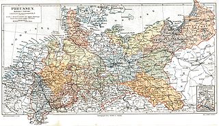
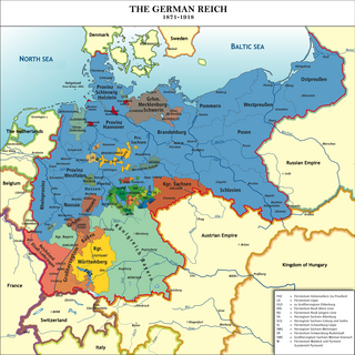
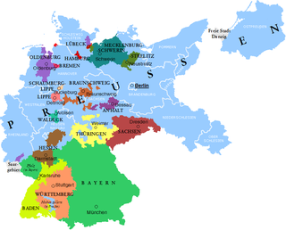
The Provinces of Prussia were the main administrative divisions of Prussia from 1815 to 1946. Prussia's province system was introduced in the Stein-Hardenberg Reforms in 1815, and were mostly organized from duchies and historical regions. Provinces were divided into several Regierungsbezirke, sub-divided into Kreise (districts), and then into Gemeinden (townships) at the lowest level. Provinces constituted the highest level of administration in the Kingdom of Prussia and Free State of Prussia until 1933, when Nazi Germany established de facto direct rule over provincial politics, and were formally abolished in 1946 following World War II. The Prussian provinces became the basis for many federal states of Germany, and the states of Brandenburg, Lower Saxony, and Schleswig-Holstein are direct successors of provinces.

<span class="mw-page-title-main">Rhine Province</span> Former province of the Kingdom of Prussia and the Free State of Prussia

The Rhine Province, also known as Rhenish Prussia or synonymous with the Rhineland, was the westernmost province of the Kingdom of Prussia and the Free State of Prussia, within the German Reich, from 1822 to 1946. It was created from the provinces of the Lower Rhine and Jülich-Cleves-Berg. Its capital was Koblenz and in 1939 it had 8 million inhabitants. The Province of Hohenzollern was militarily associated with the Oberpräsident of the Rhine Province. Also, for a short period of time, the Province of Hohenzollern was indirectly and de-facto controlled by the Rhine Province.

<span class="mw-page-title-main">Jakob Sprenger</span>

Jakob Sprenger was a Nazi Party official and politician who was the Party's Gauleiter of Hesse-Nassau South from 1927 to 1933 and Gau Hesse-Nassau from 1933 to 1945. He was also the Reichsstatthalter and Minister-President of the People's State of Hesse, the Oberpräsident of the Prussian Province of Nassau and an SA-Obergruppenführer.

<span class="mw-page-title-main">People's State of Hesse</span> State of Hesse (1918–1945)

The People's State of Hesse was one of the constituent states of Germany from 1918 to 1945, as the successor to the Grand Duchy of Hesse after the defeat of the German Empire in World War I, on the territory of the current German states of Hesse and the Rhineland-Palatinate. The State was established after Grand Duke Ernest Louis was deposed on 9 November 1918. The term "People's State" referred to the fact that the new state was a Republic and was used in the same manner as the term Free State, which was employed by most of the other German States in this period.

<span class="mw-page-title-main">Greater Hesse</span> Provisional name for a section of German territory

Greater Hesse was the provisional name given for a section of German territory created by the United States military administration in at the end of World War II. It was formed by the Allied Control Council on 19 September 1945 and became the modern German state of Hesse on 1 December 1946.

<span class="mw-page-title-main">Free State of Bottleneck</span> 1919–1923 quasi-state in western Germany

The Free State of Bottleneck was a short-lived quasi-state that existed from 10 January 1919 until 25 February 1923. It was formed out of part of the Prussian province of Hesse-Nassau as a consequence of the occupation of the Rhineland following World War I. The Bottleneck is now part of the modern German states of Hesse and Rhineland-Palatinate.

<span class="mw-page-title-main">Gauliga Südwest/Mainhessen</span> Football league

The Gauliga Südwest/Mainhessen was the highest football league in the German state of Hesse, the Bavarian province of Palatinate, the Saarland and some parts of the Prussian province of Hesse-Nassau from 1933 to 1941. From 1941, it also included parts of the occupied French region of Lorraine. Additionally, the league was from then on divided in the Gauligas Hessen-Nassau and Westmark.

<span class="mw-page-title-main">Gauliga Hessen</span> Football league

The Gauliga Hessen was the highest football league in the German state of Hesse and the Prussian province of Hesse-Nassau from 1933 to 1945. From 1941, it was renamed Gauliga Kurhessen. Shortly after the formation of the league, the Nazis reorganised the administrative regions in Germany, and the GauElectoral Hesse replaced the Prussian province and the Peoples State.

<span class="mw-page-title-main">Southern German football championship</span> Football league

The Southern German football championship was the highest association football competition in the southern Germany, established in 1898. The competition was disbanded in 1933 with the rise of the Nazis to power.

<span class="mw-page-title-main">Kreisliga Nordmain</span> Football league

The Kreisliga Nordmain was the highest association football league in parts of the German state of Hesse and the Prussian province of Hesse-Nassau from 1919 to 1923. The league was disbanded with the introduction of the Bezirksliga Main in 1923.

<span class="mw-page-title-main">Kreisliga Hessen</span> Football league

The Kreisliga Hessen was the highest association football league in parts of the German state of Hesse (Rheinhessen) and parts of the Bavarian region of Palatinate as well as the Prussian province of Hesse-Nassau from 1919 to 1923. The league was disbanded with the introduction of the Bezirksliga Rheinhessen-Saar in 1923.

The abolition of Prussia took place on 25 February 1947 through a decree of the Allied Control Council, the governing body of post-World War II occupied Germany and Austria. The rationale was that by doing away with the state that had been at the center of German militarism and reaction, it would be easier to preserve the peace and for Germany to develop democratically.

<span class="mw-page-title-main">Southern German Football Association</span> Regional association of the German Football Association

The Southern German Football Association, the SFV, is one of five regional organisations of the German Football Association, the DFB, and covers the states of Baden-Württemberg, Bavaria and Hesse.

<span class="mw-page-title-main">Campaign of the Main</span> Campaign of the 1866 Austro-Prussian War

The Campaign of the Main was a campaign of the Prussian Army in the area of the River Main against the allies of Austria in southern Germany during the Austro-Prussian War of 1866.

<span class="mw-page-title-main">American occupation zone in Germany</span> Zone of American occupation in postwar Germany

The American occupation zone in Germany, also known as the US-Zone, and the Southwest zone, was one of the four occupation zones established by the Allies of World War II in Germany west of the Oder–Neisse line in July 1945, around two months after the German surrender and the end of World War II in Europe. It was controlled by the Office of Military Government, United States (OMGUS) and ceased to exist after the establishment of the Federal Republic of Germany on 21 September 1949, but United States maintains military presence across Germany.

References

  1. "Germany After 1945 -". www.europe-today.com.
  2. "Volume 8. Occupation and the Emergence of Two States, 1945-1961" (PDF). German History in Documents and Images. p. 3.
  3. Clay 1974, p. 34.

Sources