Related Research Articles

A tornado is a violently rotating column of air that is in contact with both the surface of the Earth and a cumulonimbus cloud or, in rare cases, the base of a cumulus cloud. It is often referred to as a twister, whirlwind or cyclone, although the word cyclone is used in meteorology to name a weather system with a low-pressure area in the center around which, from an observer looking down toward the surface of the Earth, winds blow counterclockwise in the Northern Hemisphere and clockwise in the Southern. Tornadoes come in many shapes and sizes, and they are often visible in the form of a condensation funnel originating from the base of a cumulonimbus cloud, with a cloud of rotating debris and dust beneath it. Most tornadoes have wind speeds less than 180 kilometers per hour, are about 80 meters across, and travel several kilometers before dissipating. The most extreme tornadoes can attain wind speeds of more than 480 kilometers per hour (300 mph), are more than 3 kilometers (2 mi) in diameter, and stay on the ground for more than 100 km (62 mi).
The Fujita scale, or Fujita–Pearson scale, is a scale for rating tornado intensity, based primarily on the damage tornadoes inflict on human-built structures and vegetation. The official Fujita scale category is determined by meteorologists and engineers after a ground or aerial damage survey, or both; and depending on the circumstances, ground-swirl patterns, weather radar data, witness testimonies, media reports and damage imagery, as well as photogrammetry or videogrammetry if motion picture recording is available. The Fujita scale was replaced with the Enhanced Fujita scale (EF-Scale) in the United States in February 2007. In April 2013, Canada adopted the EF-Scale over the Fujita scale along with 31 "Specific Damage Indicators" used by Environment Canada (EC) in their ratings.

This article lists various tornado records. The most "extreme" tornado in recorded history was the Tri-State tornado, which spread through parts of Missouri, Illinois, and Indiana on March 18, 1925. It is considered an F5 on the Fujita Scale, even though tornadoes were not ranked on any scale at the time. It holds records for longest path length at 219 miles (352 km), longest duration at about 3½ hours, and it held the fastest forward speed for a significant tornado at 73 mph (117 km/h) anywhere on Earth until 2021. In addition, it is the deadliest single tornado in United States history with 695 fatalities. It was also the third most costly tornado in history at the time, but has been surpassed by several others non-normalized. When costs are normalized for wealth and inflation, it still ranks third today.
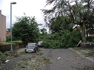
The 2005 Birmingham tornado was one of the strongest tornadoes recorded in Great Britain in nearly 30 years, occurring on 28 July 2005 in the suburbs of Birmingham. It formed on a day when thunderstorms were expected to develop across the Midlands and eastern England. The tornado struck at approximately 14:30 BST in the Sparkbrook area and also affected King's Heath, Moseley and Balsall Heath as it carved a 7 kilometre-long path through the city.
The TORRO tornado intensity scale is a scale measuring tornado intensity between T0 and T11. It was proposed by Terence Meaden of the Tornado and Storm Research Organisation (TORRO), a meteorological organisation in the United Kingdom, as an extension of the Beaufort scale.
The Enhanced Fujita scale rates tornado intensity based on the severity of the damage they cause. It is used in some countries, including the United States, Canada, China, and Mongolia.
The Tornado and Storm Research Organisation (TORRO) was founded by Terence Meaden in 1974. Originally called the Tornado Research Organisation, it was expanded in 1982 following the inclusion of the Thunderstorm Census Organisation (TCO) after the death of its founder Morris Bower and his wife. The current Head of TORRO is Paul Knightley, a professional meteorologist.
From May 4–10, 1933, a tornado outbreak sequence produced at least 33 tornadoes. Among them was the Beaty Swamp tornado, a violent F4 that struck shortly after midnight CST on May 11, 1933, in Overton County, Tennessee, killing 35 people, injuring 150 others, and devastating the unincorporated communities of Beaty Swamp and Bethsaida. The storm was the second-deadliest tornado in the history of Middle Tennessee, even though it struck a sparsely populated, rural area. The community of Beaty Swamp ceased to exist and does not appear on any current maps. The only landmark that alludes to the former community is Beaty Swamp Road, which intersects Highway 111 in the northeast corner of Overton County. The severe weather event that generated the tornado also produced others, including long-tracked, intense tornadoes or tornado families that devastated portions of Alabama, South Carolina, and Kentucky, killing a combined total of 76 people.

Tornado intensity is the measure of wind speeds and potential risk produced by a tornado. Intensity can be measured by in situ or remote sensing measurements, but since these are impractical for wide-scale use, intensity is usually inferred by proxies, such as damage. The Fujita scale, Enhanced Fujita scale, and the International Fujita scale rate tornadoes by the damage caused. In contrast to other major storms such as hurricanes and typhoons, such classifications are only assigned retroactively. Wind speed alone is not enough to determine the intensity of a tornado. An EF0 tornado may damage trees and peel some shingles off roofs, while an EF5 tornado can rip well-anchored homes off their foundations, leaving them bare; even deforming large skyscrapers. The similar TORRO scale ranges from a T0 for extremely weak tornadoes to T11 for the most powerful known tornadoes. Doppler radar data, photogrammetry, and ground swirl patterns may also be analyzed to determine the intensity and assign a rating.
The 2006 London tornado was a significant United Kingdom tornado spawned from a squall line moving over the city on 7 December 2006 at approximately 11:02 GMT. Its intensity is estimated to have been T5 on the TORRO scale, equating to F2 on the Fujita scale.
The 1981 United Kingdom tornado outbreak is regarded as the largest recorded tornado outbreak in European history. In the span of 5 hours and 26 minutes during the late morning and early afternoon of 23 November 1981, 104 confirmed tornadoes touched down across Wales and central, northern and eastern England.

The July 1968 United Kingdom thunderstorms were the most severe dust fall thunderstorms in the British Isles for over 200 years. A layer of mineral dust blowing north from the Sahara met cold, wet air over the British Isles, resulting in thick, dense clouds and severe thunderstorms across most of England and Wales. These clouds completely blotted out the light in some areas and the rain and hail resulted in property damage and flooding, and at least four people were killed. During the storm, Leeming Bar in North Yorkshire saw 35.7 millimetres (1.41 in) of rain in under 10 minutes – a UK record until 2003.
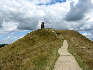
On 11 September 1275, an earthquake struck the south of Great Britain. The epicentre is unknown, although it may have been in the Portsmouth/Chichester area on the south coast of England or in Glamorgan, Wales. The earthquake is known for causing the destruction of St Michael's Church on Glastonbury Tor in Somerset.
The International Fujita scale rates the intensity of tornadoes and other wind events based on the severity of the damage they cause. It is used by the European Severe Storms Laboratory (ESSL) and various other organizations including Deutscher Wetterdienst (DWD) and State Meteorological Agency (AEMET). The scale is intended to be analogous to the Fujita and Enhanced Fujita scales, while being more applicable internationally by accounting for factors such as differences in building codes.
References
- ↑ Rowe, M. W. (1976). "Tornadoes in medieval Britain" (PDF). Journal of Meteorology. 1 (7): 219–222. ISSN 1748-2992.
- ↑ "Tornado Country – NOVA – PBS". www.pbs.org.
- 1 2 3 Rowe, Michael (November 1999). "'Work of the devil': Tornadoes in the British Isles to 1660" (PDF). Journal of Meteorology. 24 (243): 326–338. ISSN 1748-2992 . Retrieved 12 February 2022.
- 1 2 3 "British & European Extremes". The Tornado & Storm Research Organisation (TORRO). Archived from the original on 28 April 2015. Retrieved 12 February 2022.
- ↑ Schofield, John; Vince, Alan (2003). Medieval Towns: The Archaeology of British Towns in Their European Setting. Continuum International Publishing Group. p. 26. ISBN 978-0-8264-6002-8.