Los Angeles Mall

Last updated
Los Angeles Mall
Los Angeles Mall.jpg
Los Angeles Mall in 2022
Los Angeles Mall
Location Los Angeles, California, United States
Coordinates 34°03′16″N118°14′27″W / 34.0544°N 118.2408°W / 34.0544; -118.2408 Coordinates: 34°03′16″N118°14′27″W / 34.0544°N 118.2408°W / 34.0544; -118.2408
Address300 North Main Street
Opening date1970s

Triforium sculpture Triforium Fridays Night 2.jpg
Triforium sculpture
2005 view of the Los Angeles Plaza (brick buildings at top left), Union Station (top right) and the north plaza of the Los Angeles Mall (bottom center) View N along Main and Los Angeles streets from Los Angeles Mall N to Plaza and Terminal Annex 2005.jpg
2005 view of the Los Angeles Plaza (brick buildings at top left), Union Station (top right) and the north plaza of the Los Angeles Mall (bottom center)

The Los Angeles Mall is a small shopping center and series of plazas (public squares) at the Los Angeles Civic Center, between Main and Los Angeles Streets on the north and south sides of Temple Street, connected by both a pedestrian bridge and a tunnel. It features Joseph Young's sculpture Triforium, a colorful sculpture unveiled in 1975, which has 1,500 blown-glass prisms synchronized to an electronic glass bell carillon. The mall opened in 1974 and includes a four-level parking garage with 2,400 spaces. It stands on the site of what once was some of the oldest commercial blocks in the city that was demolished in the 1940s and 1950s.

Contents

The mall was designed by the architectural firm Stanton & Stockwell, which also designed the Los Angeles County Courthouse and Kenneth Hahn L.A. County Hall of Administration. It was conceived as a "town square" for meetings, retail, public institutions, and public art, serving the general public and the tens of thousands of government employees working at the Civic Center's municipal, state, and federal buildings. Cornell, Bridgers, Troller and Hazlett were the landscape designers. [1]

Plan to demolish

The site is large to be demolished, along with the new “Los Angeles Street Civic Building” (LASCB) on the site of the demolished Parker Center, as part of a larger project to diversify, revitalize and reconnect the district. [2]

Plazas

The plazas are primarily paved and lined with city government buildings. In and around the plazas are grass lawns and planters of flowering shrubs, and specimen trees. [3]

The South Mall surrounds City Hall East, an 18-story, Brutalist, 1972 building also by Stanton & Stockwell, [4] featuring a mural by Millard Sheets, The Family of Man. [5] Around the edges are a mix of tall deciduous trees. Here is the Howard Troller and Hanns Scharff's 1974 Eleanor Chambers Memorial Fountain (nicknamed Dan-de-lion). Also here are two Chinese lions celebrating the 200th Anniversary of the signing of United States Declaration of Independence. The Sunken Palm Court has paths that arc out; located here is Jan Peter Stern's 1974 stainless steel sculpture Cubed Square. [3]

The North Mall's plaza is elevated and enclosed by mature jacaranda trees. This is the location of Triforium. Another plaza, this one sunken, at the base of the former Children’s Museum includes a food court, stands of palm, and the Robert J. Stevenson Fountain, which is in the form of a pointed obelisk, red and brown in color, placed in a pool with jets of water in a centrifugal form. [3]

Bridge

Howard Troller, the Mall's landscape architect, designed a pedestrian bridge over Temple Street to connect the North and South malls, and for aesthetics, included a taper like a ship's keel into the bottom of the bridge, and asked artist Tom Van Sant to contribute further; Van Sant designed curving steps up from the street as well as the handrails on the bridge. The arc of the bridge over Temple Street was increased in order to include the steps. The bridge cantilevers out from the sidewalk toward the middle of the street. A rubber filler connects the two sections and allows them to move during an earthquake. This small bridge was a forerunner of other Los Angeles public art that is both aesthetic and functional. [6]

Tenants

Besides City Hall East and the Children's Museum, tenants in 1981 included 15 shops including Sav-on Drug Stores, 9 services including Security Pacific National Bank, and 9 food outlets including Bob's Jr. by Bob's Big Boy and a Carl's Jr. [7] As of 2022, most of the mall is now occupied by services and offices, along with a few food outlets, which include Cilantro Fresh Mexican Grill and Quiznos.

Decline

By the mid-1980s, the mall was already considered, due to lack of maintenance, an "embarrassment" and there was discussion whether the Children's Museum should take over the entire mall. [8] The Children's Museum moved to another location around 2000. Many people experiencing homelessness make use of the space and plans from 2018 included one to convert the space to housing for those currently homeless. [9] In the late 2010s the homeless population increased in the area, causing a decrease in the use of public areas by the general population. [10]

Related Research Articles

<span class="mw-page-title-main">Welton Becket</span> American architect

Welton David Becket was an American modern architect who designed many buildings in Los Angeles, California.

<span class="mw-page-title-main">Los Angeles City Hall</span> 1928 building housing the government of the city of Los Angeles, California

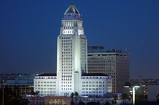
Los Angeles City Hall, completed in 1928, is the center of the government of the city of Los Angeles, California, and houses the mayor's office and the meeting chambers and offices of the Los Angeles City Council. It is located in the Civic Center district of downtown Los Angeles in the city block bounded by Main, Temple, First, and Spring streets, which was the heart of the city's central business district during the 1880s and 1890s.

<span class="mw-page-title-main">Civic Center, Los Angeles</span> Neighborhood of Los Angeles in California, United States

The Civic Center neighborhood of Los Angeles, California, is the administrative core of the City of Los Angeles, County of Los Angeles, and a complex of city, county, state, and federal government offices, buildings, and courthouses. It is located on the site of the former business district of the city during the 1880s and 1890s, since mostly-demolished.

<i>Triforium</i> (Los Angeles) Public artwork in Los Angeles, California

Triforium is a 60-foot high, concrete public art sculpture mounted with 1,494 Venetian glass prisms, light bulbs, and an internal 79-bell carillon located at Fletcher Bowron Square in the Los Angeles Mall at Temple and Main streets in the Civic Center district of Downtown Los Angeles.

<span class="mw-page-title-main">Temple Street (Los Angeles)</span>

Temple Street is a street in the City of Los Angeles, California. The street is an east-west thoroughfare that runs through Downtown Los Angeles parallel to the Hollywood Freeway between Virgil Avenue past Alameda Street to the banks of the Los Angeles River. It was developed as a simple one-block long lane by Jonathan Temple, a mid-19th Century Los Angeles cattle rancher and merchant.

Main Street is a major north–south thoroughfare in Los Angeles, California. It serves as the east–west postal divider for the city and the county as well.

<span class="mw-page-title-main">Hill Street (Los Angeles)</span> Street in Los Angeles, California, United States

Hill Street is a major north–south thoroughfare in Los Angeles, measuring 4.8 miles (7.7 km) in length. It starts on Martin Luther King, Jr. Boulevard near the campus of USC, and passes north through Downtown Los Angeles, past such landmarks as Pershing Square, the Subway Terminal Building, Angels Flight, Fort Moore and Chinatown. Hill Street merges with the Arroyo Seco Parkway near Dodger Stadium.

<span class="mw-page-title-main">Hallidie Plaza</span> Public square in San Francisco, California

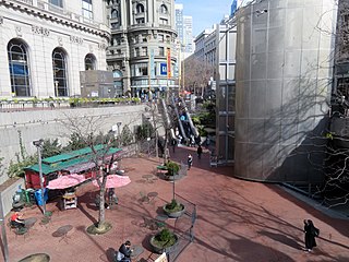
Hallidie Plaza is a public square located at the entrance to Powell Street Station on Market Street in the Union Square area of downtown San Francisco, California, United States. Hallidie Plaza was designed jointly by Lawrence Halprin, John Carl Warnecke, and Mario Ciampi and opened in 1973. In 1997, a perforated stainless steel-screened elevator was added to provide access to the plaza and station for disabled people.

<span class="mw-page-title-main">Grand Avenue (Los Angeles)</span>

Grand Avenue is a major north–south thoroughfare in Los Angeles, California. Lined with museums, concert venues, and theaters, this urban center on Bunker Hill attracts millions of people a year. Grand Park stretches between the Los Angeles City Hall and the Los Angeles Music Center on Grand Avenue. In 2007, a $3 billion Grand Avenue Project was proposed to revive Downtown Los Angeles.

<span class="mw-page-title-main">Kenneth Hahn Hall of Administration</span> Seat of government for Los Angeles County, California

Kenneth Hahn Hall of Administration, formerly the Los Angeles County Hall of Administration, completed 1960, is the seat of the government of the County of Los Angeles, California, and houses the Los Angeles County Board of Supervisors, meeting chambers, and the offices of several County departments. It is located in the Civic Center district of downtown Los Angeles, encompassing a city block bounded by Grand, Temple, Hill, and Grand Park.

<span class="mw-page-title-main">Civic Center Plaza</span> Plaza in San Francisco, United States

Civic Center Plaza, also known as Joseph Alioto Piazza, is the 4.53-acre (1.83 ha) plaza immediately east of San Francisco City Hall in Civic Center, San Francisco, in the U.S. state of California. Civic Center Plaza occupies two blocks bounded by McAllister, Larkin, Grove, and Carlton B. Goodlett, divided into a north block and south block by the former alignment of Fulton Street. The block north of Fulton is built over a three-story parking garage ; the block south of Fulton lies over a former exhibition space, Brooks Hall.

<span class="mw-page-title-main">United Nations Plaza (San Francisco)</span> Plaza in San Franciscos Civic Center

United Nations Plaza is a 2.6-acre (1.1 ha) plaza located on the former alignments of Fulton and Leavenworth Streets—in the block bounded by Market, Hyde, McAllister, and 7th Street—in the Civic Center of San Francisco, California. It is located 14 mi (0.40 km) east of City Hall and is connected to it by the Fulton Mall and Civic Center Plaza. Public transit access is provided by the BART and Muni Metro stops at the Civic Center/UN Plaza station, which has a station entrance within the plaza itself.

Joseph Young (1919–2007) was an artist well known for his public artwork, which included mosaic murals, stained glass windows, monuments and public sculptures in granite, concrete, and bronze. Over the course of his career Young completed over sixty commissions for civic, church, synagogue and other public spaces, as well as privately collected works in oil, mosaic, ceramics and other media. His largest work is the mosaic West Apse of the Basilica of the National Shrine of the Immaculate Conception in Washington, D.C., entitled "The Woman Clothed With The Sun." Notable works in Los Angeles include the Holocaust Monument, the mosaic bas-relief on the Richard Neutra-desigined Los Angeles County Hall of Records, mosaic panels on the exterior of the UCLA Math Sciences Building, and the Triforium. in Fletcher Bowron Square on the Los Angeles Mall at the Civic Center, Los Angeles.

<span class="mw-page-title-main">Victorian Downtown Los Angeles</span> Historical neighborhood in California, US

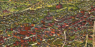
The late-Victorian-era Downtown of Los Angeles grew year by year, around 1880 centered at the southern end of the Los Angeles Plaza area, and over the next two decades, extending south and west along Main Street, Spring Street, and Broadway towards Third Street. Most of the 19th-century buildings no longer exist, surviving only in the Plaza area or south of Second Street. The rest were demolished to make way for the Civic Center district with City Hall, numerous courthouses, and other municipal, county, state and federal buildings, and Times Mirror Square. This article covers that area, between the Plaza, 3rd St., Los Angeles St., and Broadway, during the period 1880 through the period of demolition (1920s–1950s).

<span class="mw-page-title-main">Stanton & Stockwell</span>

Stanton & Stockwell was a partnership of Jesse Earl Stanton and William Francis Stockwell, two architects active in Southern California during the mid-20th century. Works attributed to them include:

References

  1. Winter, Robert (2009). An Arch Guidebook to Los Angeles. p. 261. ISBN   9781423608936.
  2. https://civiccenterprojects.lacity.org/sites/default/files/CCD%20191119%20Community%20Mtg%20%234%20Presentation_sm.pdf [ dead link ]
  3. 1 2 3 "Los Angeles Mall". Cultural Landscape Foundation.
  4. "City Hall East". Emporia. Archived from the original on November 24, 2020.
  5. "The Family of Man". Public Art in Los Angeles.
  6. "Bridge", Civic Center, Public Art in L.A.
  7. "Advertisement for Los Angeles Mall". Los Angeles Times. December 4, 1981. p. 237.
  8. Harris, Scott (May 15, 1989). "Children's Museum Nears Approval for Mall Takeover". Los Angeles Times.
  9. Chiland, Elijah (July 31, 2018). "'The time is ripe to take action': Old Children's Museum pinpointed as possible emergency homeless shelter". Curbed.
  10. Puente, Mark (October 9, 2019). "L.A. city workers feel unsafe as homeless crisis grows, prompting more LAPD patrols". Los Angeles Times.