Related Research Articles

The Rogue River in southwestern Oregon in the United States flows about 215 miles (346 km) in a generally westward direction from the Cascade Range to the Pacific Ocean. Known for its salmon runs, whitewater rafting, and rugged scenery, it was one of the original eight rivers named in the Wild and Scenic Rivers Act of 1968. Beginning near Crater Lake, which occupies the caldera left by the explosive volcanic eruption and collapse of Mount Mazama, the river flows through the geologically young High Cascades and the older Western Cascades, another volcanic province. Further west, the river passes through multiple exotic terranes of the more ancient Klamath Mountains. In the Kalmiopsis Wilderness section of the Rogue basin are some of the world's best examples of rocks that form the Earth's mantle. Near the mouth of the river, the only dinosaur fragments ever discovered in Oregon were found in the Otter Point Formation, along the coast of Curry County.
The San Lorenzo River is a 29.3-mile-long (47.2 km) river in the U.S. state of California. The name San Lorenzo derives from the Spanish language for "Saint Lawrence" due to its reported sighting on that saint's feast day by Spanish explorers. Its headwaters originate in Castle Rock State Park in the Santa Cruz Mountains and flow south by southeast through the San Lorenzo Valley before passing through Santa Cruz and emptying into Monterey Bay and the Pacific Ocean.

The Trinity River is a major river in northwestern California in the United States and is the principal tributary of the Klamath River. The Trinity flows for 165 miles (266 km) through the Klamath Mountains and Coast Ranges, with a watershed area of nearly 3,000 square miles (7,800 km2) in Trinity and Humboldt Counties. Designated a National Wild and Scenic River, along most of its course the Trinity flows swiftly through tight canyons and mountain meadows.

The Redwood National and State Parks (RNSP) are a complex of one national park and three state parks, cooperatively managed and located in the United States along the coast of northern California. Comprising Redwood National Park and California's State Parks—Del Norte Coast, Jedediah Smith, and Prairie Creek —the combined RNSP contain 139,000 acres (560 km2), and feature old-growth temperate rainforests. Located within Del Norte and Humboldt counties, the four parks protect 45 percent of all remaining coast redwood old-growth forests, totaling at least 38,982 acres (157.75 km2). The species is the tallest, among the oldest, and one of the most massive tree species on Earth. The parks also preserve other indigenous flora, fauna, grassland prairie, cultural resources, waterways, and 37 miles (60 km) of pristine coastline.

The Eel River is a major river, about 196 miles (315 km) long, of northwestern California. The river and its tributaries form the third largest watershed entirely in California, draining a rugged area of 3,684 square miles (9,540 km2) in five counties. The river flows generally northward through the Coast Ranges west of the Sacramento Valley, emptying into the Pacific Ocean about 10 miles (16 km) downstream from Fortuna and just south of Humboldt Bay. The river provides groundwater recharge, recreation, and industrial, agricultural and municipal water supply.

Lake Oroville is a reservoir formed by the Oroville Dam impounding the Feather River, located in Butte County, northern California. The lake is situated 5 miles (8 km) northeast of the city of Oroville, within the Lake Oroville State Recreation Area, in the western foothills of the Sierra Nevada. Known as the second-largest reservoir in California, Lake Oroville is treated as a keystone facility within the California State Water Project by storing water, providing flood control, recreation, freshwater releases to assist in controlling the salinity intrusion into the Sacramento-San Joaquin Delta and protecting fish and wildlife.

In 1942, the Coleman National Fish Hatchery was established under an act of the U.S. Congress to mitigate the loss of historic spawning habitat caused by the construction of dams. The fish hatchery is located in Shasta County, California near the town of Anderson on the north bank of Battle Creek approximately 6 river miles (9.7 km) east of the Sacramento River. Coleman NFH covers approximately 75 acres (300,000 m2) of land owned by the U.S. Fish and Wildlife Service (USFWS), with an additional 63 acres (250,000 m2) of land in perpetual easements for pipelines and access. It is the largest salmon hatchery in the continental United States.

Waddell Creek is the name given to both the creek and the watershed that run through Big Basin Redwoods State Park in Santa Cruz County, California. The Waddell Creek mainstem is formed by the confluence of East and West Waddell Creeks, and empties into the Pacific Ocean at Waddell Beach, just south of Año Nuevo Point.

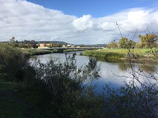
The Mad River is a river in upper Northern California. It flows for 113 miles (182 km) in a roughly northwest direction through Trinity County and then Humboldt County, draining a 497-square-mile (1,290 km2) watershed into the Pacific Ocean north of the town of Arcata near [California Redwood Coast-Humboldt County Airport] in McKinleyville. The river's headwaters are in the Coast Range near South Kelsey Ridge.

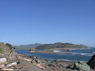
The Mattole River is a river on the north coast of California, that flows northerly, then westerly into the Pacific Ocean. The vast majority of its 62 miles (100 km) course is through southern Humboldt County, though a short section of the river flows through northern Mendocino County. Communities, from north to south, closely associated with the Mattole River include: Petrolia, Honeydew, Ettersburg, Thorn Junction, and Whitethorn. The river enters the ocean at the Mattole Estuary about 4 miles (6.4 km) west-southwest of Petrolia and 10 miles (16 km) south of Cape Mendocino.
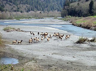
Redwood Creek is a 61.8-mile (99.5 km) river in Humboldt County, California. The river's headwaters are in the Coast Range at about 5,000 feet (1,500 m) and it flows roughly northwest until it empties into the Pacific Ocean near the small town of Orick, the only development in the 280-square-mile (730 km2)-watershed.
The Russian River is a southward-flowing river that drains 1,485 sq mi (3,850 km2) of Sonoma and Mendocino counties in Northern California. With an annual average discharge of approximately 1,600,000 acre feet (2.0 km3), it is the second-largest river flowing through the nine-county Greater San Francisco Bay Area, with a mainstem 115 mi (185 km) long.

San Francisquito Creek is a creek that flows into southwest San Francisco Bay in California, United States. Historically it was called the Arroyo de San Francisco by Juan Bautista de Anza in 1776. San Francisquito Creek courses through the towns of Portola Valley and Woodside, as well as the cities of Menlo Park, Palo Alto, and East Palo Alto. The creek and its Los Trancos Creek tributary define the boundary between San Mateo and Santa Clara counties.

Redwood Creek is a mostly perennial stream in Marin County, California. 4.7 miles (7.6 km) long, it drains a 7-square-mile (18 km2) watershed which includes the Muir Woods National Monument, and reaches the Pacific Ocean north of the Golden Gate at Muir Beach.
San Leandro Creek is a 21.7-mile-long (34.9 km) year-round natural stream in the hills above Oakland in Alameda County and Contra Costa County of the East Bay in northern California.

Issaquah Creek is a small stream flowing through the city of Issaquah and nearby communities, in the U.S. state of Washington. Its headwaters are on the slopes of Cougar, Squak, Tiger, and Taylor mountains in the Issaquah Alps. Tributaries of Issaquah Creek include Holder Creek, Carey Creek, Fifteen-mile Creek, McDonald Creek, East Fork Issaquah Creek, and North Fork Issaquah Creek. The creek empties into the south end of Lake Sammamish. The lake's outlet is the Sammamish River, which in turn empties into Lake Washington and ultimately Puget Sound.

The South Fork Eel River is the largest tributary of the Eel River in north-central California in the United States. The river flows 105 miles (169 km) north from Laytonville to Dyerville/Founders' Grove where it joins the Eel River. The South Fork drains a long and narrow portion of the Coast Range of California in parts of Mendocino and Humboldt counties. U.S. Route 101 follows the river for much of its length.
Bear Creek, or Bear Gulch Creek, is a 6.6-mile-long (10.6 km) southeastward-flowing stream originating north of the summit of Sierra Morena in the Santa Cruz Mountains, near the community of Kings Mountain in San Mateo County, California, United States. It flows through the town of Woodside. Bear Creek and Corte Madera Creek join to become San Francisquito Creek in the Jasper Ridge Biological Preserve at Stanford University.

The Prairie Creek Fish Hatchery near Orick, Humboldt County, California was one of the first small local fish hatcheries developed to improve the area's sport and commercial fishing, and is one of only three remaining hatcheries built in California from 1871 to 1946.

The Salt River is a formerly navigable hanging channel of the Eel River which flowed about 9 miles (14 km) from near Fortuna and Waddington, California, to the estuary at the Pacific Ocean, until siltation from logging and agricultural practices essentially closed the channel. It was historically an important navigation route until the early 20th century. It now intercepts and drains tributaries from the Wildcat Hills along the south side of the Eel River floodplain. Efforts to restore the river began in 1987, permits and construction began in 2012, and water first flowed in the restored channel in October 2013.
References
- 1 2 3 Sacklin, John; Ozaki, Vicki; Hofstra, Terry; Smith, Ann King (August 1988). "Environmental Assessment: Upper Dam Removal, Lost Man Creek" (PDF). Redwood National Park– via From the files of Redwood Nation Park.
- 1 2 3 Kirk, Susie Van (March 1994). "Historical Information on Redwood Creek" (PDF). waterboards.ca.gov. Retrieved 2021-04-14.
- 1 2 3 4 5 Corbett, Michael; Bradley, Denise (May 1997). "Final Historic Resources Study Report for Prairie Creek Fish Hatchery Redwood National and State Parks Humboldt County, California" (PDF). waterboards.ca.gov. Retrieved 2021-04-14.
- 1 2 Wilzbach, Margaret A. (January 28, 2016). "State Of the Fisheries & Aquatic Resources of Prairie Creek - Final Report to Redwood National and State Parks for Cooperative Agreement Number P13AC00848, Task Agreement Number P14AC01284" (PDF). Redwood National Park. Archived from the original (PDF) on 2018-05-10 – via Humboldt State University.