Monroe County is located in the Arkansas Delta in the U.S. state of Arkansas. The county is named for James Monroe, the fifth President of the United States. Created as Arkansas's 20th county on November 2, 1829, Monroe County is home to two incorporated towns and three incorporated cities, including Clarendon, the county seat, and Brinkley, the most populous city. The county is also the site of numerous unincorporated communities and ghost towns.

The White River National Wildlife Refuge is a 160,756 acres (650.56 km2) wildlife refuge located in Desha, Monroe, Phillips, and Arkansas counties in the U.S. state of Arkansas. The refuge is managed by the United States Fish and Wildlife Service. White River NWR borders on Cache River National Wildlife Refuge at its northern boundary. In 1974, the White River Sugarberry Natural Area was designated as a National Natural Landmark by the National Park Service.

Poison Springs Battleground State Park is an Arkansas state park located southeast of Bluff City. It commemorates the Battle of Poison Spring in the American Civil War, which was part of the 1864 Camden Expedition, an element of a Union Army initiative to gain control of Shreveport, Louisiana and get a foothold in Texas.

The National Register of Historic Places in the United States is a register including buildings, sites, structures, districts, and objects. The Register automatically includes all National Historic Landmarks as well as all historic areas administered by the U.S. National Park Service. Since its introduction in 1966, more than 90,000 separate listings have been added to the register.
This is a list of properties and historic districts in Arkansas that are listed on the National Register of Historic Places. There are more than 2,600 listings in the state, including at least 8 listings in each of Arkansas's 75 counties.
Meridian-Baseline State Park is a historic preservation area covering 108 acres (44 ha) in Ingham County and Jackson County, Michigan, containing the intersection of the Michigan meridian and the baseline used for the Michigan Survey. The state park has two monuments that show where the two mismatched baselines meet the principal meridian at the North Initial Point and South Initial Point.

Davidsonville Historic State Park is a 163-acre (66 ha) Arkansas state park in Randolph County, Arkansas in the United States. Situated on a border between The Ozarks and the Arkansas Delta, the park preserves the remains of the abandoned frontier town of Davidsonville. The town was one of Arkansas Territory's first settlements when founded in 1815, serving as an important river port town on the Black River. The former townsite was made into a state park in 1957 and a monument was added to the National Register of Historic Places in 1974.
Joseph Cromwell Brown was an American surveyor known for establishing the Fifth Principal Meridian's baseline that governs the surveys of all or part of present-day Arkansas, Iowa, Minnesota, Missouri, and South Dakota. The Fifth Principal Meridian was established in 1815 to survey the territory of the Louisiana Purchase, an area of 830,000 square miles (2,100,000 km2).
The Jenkins' Ferry Battleground State Park, also known as the Jenkins' Ferry Battlefield, is a battlefield in Grant County, Arkansas. The Arkansas state park commemorates the Battle of Jenkins' Ferry fought on Saturday, April 30, 1864, during the Red River Campaign of the American Civil War.
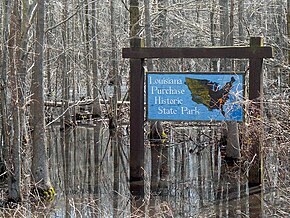
Blackton is an unincorporated community in Monroe County, Arkansas, United States. According to The Encyclopedia of Arkansas History and Culture, "little remains of the town." Two nationally registered historic sites are located in or near Blackton. The Palmer House is a brick home built in 1873 located near Blackton that has been listed on the National Register of Historic Places. The location where the survey of lands acquired in the Louisiana Purchase is located two miles outside of Blackton, now known as Louisiana Purchase State Park, and has been listed as a National Historic Landmark.
The Arkansas Delta is one of the six natural regions of the state of Arkansas. Willard B. Gatewood Jr., author of The Arkansas Delta: Land of Paradox, says that rich cotton lands of the Arkansas Delta make that area "The Deepest of the Deep South."

The Beginning Point of the U.S. Public Land Survey is the point from which the United States in 1786 began the formal survey of the lands known then as the Northwest Territory, now making up all or part of Ohio, Indiana, Illinois, Michigan, Wisconsin, and Minnesota. The survey is claimed to be the first major cadastral survey undertaken by any nation. The point now lies underwater on the state line between Ohio and Pennsylvania. Because it is submerged, a monument commemorating the point is adjacent to the nearest roadway and located on the state line between East Liverpool, Ohio and Ohioville, Pennsylvania. The area around the marker was designated a National Historic Landmark in 1965.

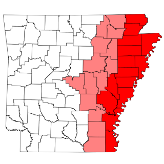
The Fifth Principal Meridian, also known as the "5th Principal Meridian" and "PM 05", is a principal meridian survey line used in the United States for land claims in the Public Land Survey System (PLSS). It was first surveyed in 1815. The meridian, a north-south line, starts from the old mouth of the Arkansas River and runs north. Another survey line related to it is the base line running west from the old mouth of the St. Francis River. These survey lines govern all land surveys in four states and a large portion of the land surveys for two more. Monuments have been erected where the two lines meet at 34°38′44″N91°3′42″W, and the surveyors' skill has been commemorated at the Louisiana Purchase State Park in eastern Arkansas. The Fifth Principal Meridian is nearly coincident with 91° 3′ 42″ longitude west from the Greenwich meridian.

Pointe Mouillee State Game Area is a state game area in the U.S. state of Michigan. It encompasses 7,483 acres (30.3 km2) of hunting, recreational, and protected wildlife and wetland areas at the mouth of the Huron River at Lake Erie, as well as smaller outlying areas within the Detroit River. Pointe Mouillee State Game Area was established in 1945 and is administered by the Michigan Department of Natural Resources.
Prospect K. Robbins was an American surveyor known for establishing the Fifth Principal Meridian that governs the surveys of all or part of present-day Arkansas, Iowa, Minnesota, Missouri, and South Dakota. The Fifth Principal Meridian was established in 1815 to survey the territory of the Louisiana Purchase, an area of 830,000 square miles (2,100,000 km2).
Fairview-Riverside State Park is a tourist attraction 2 miles (3.2 km) east of Madisonville, Louisiana, United States. Its 99 acres (400,000 m2) is set along the banks of the Tchefuncte River. Within the park is the Otis House Museum, built in 1885, which was placed on the National Register of Historic Places in 1999. Visitors go to Fairview-Riverside to camp, and for water sports and fishing. The park has 100 campsites, a short nature trail, and a boardwalk which reveals forested wetlands along the Tchefuncte River.

In surveying, an initial point is a datum that marks the beginning point for a cadastral survey. The initial point establishes a local geographic coordinate system for the surveys that refer to that point.

The International Boundary Marker, also known as the Republic of Texas Granite Marker, is a boundary marker located on the Louisiana-Texas border near the junction of Texas FM 31 and Louisiana Highway 765, southeast of Deadwood, Texas. The marker was created in 1840 and placed in 1841 to mark the international border between the United States and the Republic of Texas. The survey which established this border lasted from May 1840 to June 1841; the survey team faced hazardous, swampy conditions in their work and were forced to take several extended breaks due to weather and a lack of funding. The boundary marker is the only marker remaining from the Texas border survey and is one of only two known international boundary markers located entirely within the United States.

The Marianna Commercial Historic District encompasses the historic civic and commercial heart of Marianna, Arkansas, the county seat of Lee County. It comprises two blocks of Main Street and two blocks of Poplar Street, which cross at the northwest corner of Court Square, a city park where the Gen. Robert E. Lee Monument is found, and extends south to include a few buildings on Liberty Street.
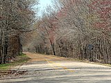 Entrance to the park on State Highway 362.
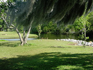
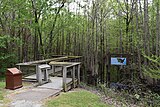 Footpath leading to the boardwalk.
 Boardwalk leading to the site.
 Louisiana Purchase Survey Marker.