
Landslides, also known as landslips, are several forms of mass wasting that may include a wide range of ground movements, such as rockfalls, deep-seated slope failures, mudflows, and debris flows. Landslides occur in a variety of environments, characterized by either steep or gentle slope gradients, from mountain ranges to coastal cliffs or even underwater, in which case they are called submarine landslides.

A megatsunami is a very large wave created by a large, sudden displacement of material into a body of water.
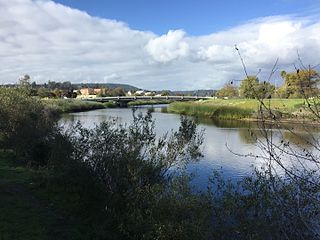
The San Lorenzo River is a 29.3-mile-long (47.2 km) river in the U.S. state of California. The name San Lorenzo derives from the Spanish language for "Saint Lawrence" due to its reported sighting on that saints feast day by Spanish explorers. Its headwaters originate in Castle Rock State Park in the Santa Cruz Mountains and flow south by southeast through the San Lorenzo Valley before passing through Santa Cruz and emptying into Monterey Bay and the Pacific Ocean.

Peeks Creek is a stream located in Macon County, North Carolina. It is a tributary of the Cullasaja River, into which it flows a few miles or kilometers upstream of Franklin.
La Conchita is a small unincorporated community in western Ventura County, California, on U.S. Route 101 just southeast of the Santa Barbara county line. The ZIP Code is 93001, and the community is inside area code 805.
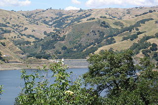
Calaveras Reservoir is located primarily in Santa Clara County, California, with a small portion and its dam in Alameda County, California. In Spanish, Calaveras means "skulls".

The Diablo Range is a mountain range in the California Coast Ranges subdivision of the Pacific Coast Ranges in northern California, United States. It stretches from the eastern San Francisco Bay area at its northern end to the Salinas Valley area at its southern end.

A mudflow, also known as mudslide or mud flow, is a form of mass wasting involving fast-moving flow of debris and dirt that has become liquified by the addition of water. Such flows can move at speeds ranging from 3 meters/minute to 5 meters/second. Mudflows contain a significant proportion of clay, which makes them more fluid than debris flows, allowing them to travel farther and across lower slope angles. Both types of flow are generally mixtures of particles with a wide range of sizes, which typically become sorted by size upon deposition.

The Vargas tragedy was a natural disaster that occurred in Vargas State, Venezuela on 14–16 December 1999, when torrential rains caused flash floods and debris flows that killed tens of thousands of people, destroyed thousands of homes, and led to the complete collapse of the state's infrastructure. According to relief workers, the neighborhood of Los Corales was buried under 3 metres (9.8 ft) of mud and a high percentage of homes were simply swept into the ocean. Entire towns including Cerro Grande and Carmen de Uria completely disappeared. As much as 10% of the population of Vargas died during the event.
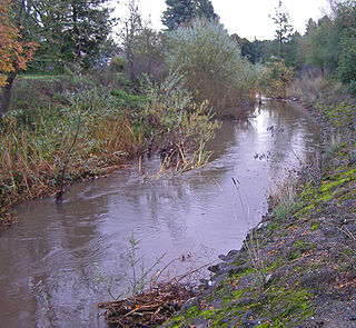
Brush Creek or Rincon Creek is a tributary of Santa Rosa Creek in Sonoma County, California. Brush Creek rises in the southern slopes of the Mayacamas Mountains within Sonoma County. The lower reach of the creek is a suburban medium density residential area in the city of Santa Rosa, and that reach of Brush Creek has been restored during the 1990s under a U.S. Environmental Protection Agency grant to promote steelhead migration and spawning. Further restoration and incorporation into citywide park planning is currently underway as of 2006. The location of the confluence with Santa Rosa Creek is particularly noteworthy, since it was a locus of prehistoric life as a village of the Pomo people and a scenic geologic feature of massive flat boulder outcrops within the stream channel.

Loch Lomond is a reservoir in the Santa Cruz Mountains near Lompico in Santa Cruz County, California. Part of the Santa Cruz Water Department system, it was created by building the Newell Creek Dam across Newell Creek – a tributary of the San Lorenzo River. The dam is an earth-fill barricade, measuring 190 ft (58 m) by 750 ft (230 m). It was financed by bond issuance, and completed in the Fall of 1960; impounded water first ran over the spillway in March 1963.

Carbonera Creek is a 10.2-mile-long (16.4 km) watercourse in Santa Cruz County, California, that eventually flows to the San Lorenzo River.

The 1958 Lituya Bay earthquake occurred on PST with a moment magnitude of 7.8 to 8.3 and a maximum Mercalli intensity of XI (Extreme). The strike-slip earthquake took place on the Fairweather Fault and triggered a rockslide of 30 million cubic meters and about 90 million tons into the narrow inlet of Lituya Bay, Alaska. The impact was heard 80 kilometers (50 mi) away, and the sudden displacement of water resulted in a megatsunami that washed out trees to a maximum elevation of 524 meters at the entrance of Gilbert Inlet. This is the largest and most significant megatsunami in modern times; it forced a re-evaluation of large-wave events and the recognition of impact events, rockfalls, and landslides as causes of very large waves.
Landslides in California occur mainly due to intense rainfall but occasionally are triggered by earthquakes. Landslides are common in Southern California, the San Francisco Bay Area and other parts of Northern California, and the Sierra Nevada. Although they most often are reported when they impact residential developments, landslides also damage roads, railroads, pipelines, electrical lines, and other infrastructure throughout the state, and occur in unoccupied parts of the state.

The Christmas flood of 1964 was a major flood in the United States' Pacific Northwest and some of Northern California between December 18, 1964, and January 7, 1965, spanning the Christmas holiday. Considered a 100-year flood, it was the worst flood in recorded history on nearly every major stream and river in coastal Northern California and one of the worst to affect the Willamette River in Oregon. It also affected parts of southwest Washington, Idaho, and Nevada. In Oregon, 17 or 18 people died as a result of the disaster, and it caused hundreds of millions of dollars in damage. The flooding on the Willamette covered 152,789 acres (61,831.5 ha). The National Weather Service rated the flood as the fifth most destructive weather event in Oregon in the 20th century. California Governor Pat Brown was quoted as saying that a flood of similar proportions could "happen only once in 1,000 years," and it was often referred to later as the Thousand Year Flood. The flood killed 19 people, heavily damaged or completely devastated at least 10 towns, destroyed all or portions of more than 20 major highway and county bridges, carried away millions of board feet of lumber and logs from mill sites, devastated thousands of acres of agricultural land, killed 4,000 head of livestock, and caused $100 million in damage in Humboldt County, California, alone.

The town of La Conchita, California, experienced major landslides in 1995 and 2005. The latter landslide killed 10 people, and destroyed or damaged dozens of houses. The 2005 landslide occurred on part of a previous landslide that occurred in 1995. The historic slides are part of the larger Rincon Mountain slide, which "started many thousands of years ago and will continue generating slides in the future."

A major landslide occurred 4 miles (6.4 km) east of Oso, Washington, United States, on March 22, 2014, at 10:37 a.m. local time. A portion of an unstable hill collapsed, sending mud and debris to the south across the North Fork of the Stillaguamish River, engulfing a rural neighborhood, and covering an area of approximately 1 square mile (2.6 km2). Forty-three people were killed and 49 homes and other structures destroyed.

Thomes Creek is a major watercourse on the west side of the Sacramento Valley in Northern California. The creek originates in the Coast Ranges and flows east for about 62 miles (100 km) to join the Sacramento River, at a point about 7 miles (11 km) northeast of Corning in Tehama County.

The 2017 California floods affected parts of California in the first half of the year. Northern California saw its wettest winter in almost a century, breaking the record set in 1982–83. The same storm systems also flooded parts of western Nevada and southern Oregon. The damage was estimated at $1.55 billion ($1,713,501,222 today), including damage to California roads and highways estimated at more than $1.05 billion.

The West Salt Creek landslide occurred on the evening of May 25, 2014 near Collbran, Colorado, along the north side of the Grand Mesa, about 30 miles (48 km) east of Grand Junction. It was the largest landslide in Colorado's history.
