Loves Park, Illinois

Last updated

Loves Park
Flag of Loves Park, Illinois.png
Seal of Loves Park.JPG
Motto: 
The City with a Heart
Boone County Illinois Incorporated and Unincorporated areas Loves Park Highlighted.svg
Location of Loves Park in Boone County & Winnebago County, Illinois.
Illinois in United States (US48).svg
Location of Illinois in the United States
Coordinates: 42°19′34″N89°01′33″W / 42.32611°N 89.02583°W / 42.32611; -89.02583
CountryUnited States
StateIllinois
County Winnebago - Boone
Government
   Mayor Greg Jury [1]
Area
[2]
  Total16.85 sq mi (43.65 km2)
  Land16.32 sq mi (42.28 km2)
  Water0.53 sq mi (1.37 km2)
Elevation
[3]
728 ft (222 m)
Population
 (2020)
  Total23,397
  Density1,433.20/sq mi (553.35/km2)
Time zone UTC−6 (CST)
  Summer (DST) UTC−5 (CDT)
ZIP Code(s)
61131, 61132, 61111, 61130
Area codes 779/815
FIPS code 17-45031
Wikimedia CommonsCategory:Loves Park, Illinois
Website https://cityoflovespark.com/

Loves Park is a city in Boone and Winnebago counties in the U.S. state of Illinois. Most of the city is in Winnebago County, with a tiny sliver in the east located in Boone County. The population was 23,397 at the 2020 census.

Contents

Loves Park is part of the Rockford Metropolitan Statistical Area.

History

Malcolm Love, an industrialist in Rockford, Illinois, purchased 236 acres of land in this area in 1901 and set up a gathering place that came to be known as Love's Park. The city of Loves Park was incorporated in 1947. [4] When the city's economy was negatively affected by the early 1980s recession, City Hall was moved from the Grand Avenue fire station into the Marshall Middle School to save money. [5] In 2001, Danfoss moved their plant from Rockford to Loves Park, becoming one of the town's largest employers. [6]

Geography

Loves Park is located at 42°19′34″N89°1′33″W / 42.32611°N 89.02583°W / 42.32611; -89.02583 (42.326227, -89.025739). [7]

According to the 2021 census gazetteer files, Loves Park has a total area of 16.85 square miles (43.64 km2), of which 16.33 square miles (42.29 km2) (or 96.86%) is land and 0.53 square miles (1.37 km2) (or 3.14%) is water. [8]

Demographics

Historical population
CensusPop.Note
1950 5,366
1960 9,08669.3%
1970 12,39036.4%
1980 13,1926.5%
1990 15,46217.2%
2000 20,04429.6%
2010 23,99619.7%
2020 23,397−2.5%
U.S. Decennial Census [9] [10]

As of the 2020 census [11] there were 23,397 people, 9,608 households, and 6,138 families residing in the city. The population density was 1,388.22 inhabitants per square mile (535.99/km2). There were 10,640 housing units at an average density of 631.30 per square mile (243.75/km2). The racial makeup of the city was 79.42% White, 5.48% African American, 0.30% Native American, 3.59% Asian, 0.03% Pacific Islander, 2.92% from other races, and 8.25% from two or more races. Hispanic or Latino of any race were 8.89% of the population.

There were 9,608 households, out of which 31.0% had children under the age of 18 living with them, 43.69% were married couples living together, 15.02% had a female householder with no husband present, and 36.12% were non-families. 29.20% of all households were made up of individuals, and 12.39% had someone living alone who was 65 years of age or older. The average household size was 2.94 and the average family size was 2.41.

The city's age distribution consisted of 21.7% under the age of 18, 9.4% from 18 to 24, 25.6% from 25 to 44, 25.8% from 45 to 64, and 17.5% who were 65 years of age or older. The median age was 38.0 years. For every 100 females, there were 95.5 males. For every 100 females age 18 and over, there were 90.2 males.

The median income for a household in the city was $57,096, and the median income for a family was $66,914. Males had a median income of $49,182 versus $28,021 for females. The per capita income for the city was $31,504. About 9.9% of families and 14.7% of the population were below the poverty line, including 27.9% of those under age 18 and 6.3% of those age 65 or over.

Transportation

RMTD provides bus service on Routes 16, 17, 18, 20 and 22 connecting Loves Park to downtown Rockford and other destinations. [12]

Notable people

Related Research Articles

<span class="mw-page-title-main">Winnebago County, Illinois</span> County in Illinois, United States

Winnebago County is a county located in the U.S. state of Illinois. According to the 2020 census, it had a population of 285,350 making it the seventh most populous county in Illinois behind Cook County and its five surrounding collar counties. Its county seat is Rockford. Winnebago County is the central county of the Rockford Metropolitan Statistical Area.

<span class="mw-page-title-main">Calion, Arkansas</span> City in Arkansas, United States

Calion is a second-class city in Union County, Arkansas, United States. The population was 494 at the 2010 census.

<span class="mw-page-title-main">Caledonia, Illinois</span> Village in Illinois, United States

Caledonia is a village in Caledonia Township, Boone County, Illinois, United States. It is part of the Rockford, Illinois Metropolitan Statistical Area. The population was 183 at the 2020 census.

<span class="mw-page-title-main">Arlington, Illinois</span> Village in Illinois, United States

Arlington is a village in Bureau County, Illinois, United States. The population was 169 at the 2020 census. It is part of the Ottawa Micropolitan Statistical Area, located east of the Quad Cities, north of Peoria and Galesburg, west of LaSalle and Peru, and southwest of Rockford and Chicago.

<span class="mw-page-title-main">DePue, Illinois</span> Village in Illinois, United States

DePue is a village in Bureau County, Illinois, United States. The population was 1,633 at the 2020 census. It is part of the Ottawa Micropolitan Statistical Area.

<span class="mw-page-title-main">Zeigler, Illinois</span> City in Illinois, United States

Zeigler is a city in Franklin County, Illinois, United States. The population was 1,484 at the 2020 census.

<span class="mw-page-title-main">Davis Junction, Illinois</span> Village in Illinois, United States

Davis Junction is a village in Ogle County, Illinois, United States. The population was 2,512 at the 2020 census. Named for Jeremiah Davis, it is located where the Illinois Railway Rockford Line and the Canadian Pacific Railway Chicago Subdivision intersect along Illinois Route 72. It is the site of the Orchard Hills Landfill - one of the largest in the United States.

<span class="mw-page-title-main">German Valley, Illinois</span> Village in Illinois, United States

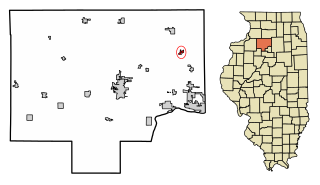
German Valley is a village in Stephenson County, Illinois, United States. German Valley is located four miles south of U.S. Route 20 between Freeport and Rockford. German Valley had a population of 433 at the 2020 census, with a 2023 estimate of 424.

<span class="mw-page-title-main">Lake Summerset, Illinois</span> Census Designated Place in Illinois, United States

Lake Summerset is a census-designated place (CDP) in Stephenson and Winnebago counties in Illinois. The population was 2,048 at the 2010 census.

<span class="mw-page-title-main">Prophetstown, Illinois</span> City in Illinois, United States

Prophetstown is a city in Whiteside County, Illinois, United States. The population was 2,080 at the 2010 census, up from 2,023 in 2000.

<span class="mw-page-title-main">Durand, Illinois</span> Village in Illinois, United States

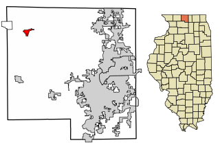
Durand is a village in Winnebago County, Illinois, United States. It is part of the Rockford, Illinois Metropolitan Statistical Area The population was 1,443 at the 2010 census, up from 1,081 in 2000.

<span class="mw-page-title-main">Machesney Park, Illinois</span> Village in Illinois, United States

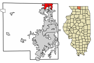
Machesney Park is a village located in Winnebago County, Illinois, United States. The population was 23,499 at the 2010 census, up from 20,759 in 2000. Machesney Park is part of the Rockford, Illinois Metropolitan Statistical Area.

<span class="mw-page-title-main">New Milford, Illinois</span> Village in Illinois, United States

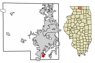
New Milford is a village in Winnebago County, Illinois, United States on the south bank of the Kishwaukee River overlooking the south side of Rockford. It is part of the Rockford, Illinois Metropolitan Statistical Area. The population was 697 at the 2010 census, up from 541 in 2000.

<span class="mw-page-title-main">Pecatonica, Illinois</span> Village in Illinois, United States

Pecatonica is a village in Winnebago County, Illinois, United States. It is part of the Rockford, Illinois Metropolitan Statistical Area. The population was 2,195 at the 2010 census, up from 1,997 in 2000.

<span class="mw-page-title-main">Rockton, Illinois</span> Village in Illinois, United States

Rockton is a village in Winnebago County, Illinois. It is located in the Rock River Valley and is part of the Rockford metropolitan area. The population was 7,685 at the time of the 2010 census, up from 5,296 at the time of the 2000 census.

<span class="mw-page-title-main">Roscoe, Illinois</span> Village in Illinois, United States

Roscoe is a village in Winnebago County, Illinois, along the Rock River. It is in a suburban area of the Rockford, Illinois Metropolitan Statistical Area. As of the 2010 census, the village population was 10,785, up from 6,244 at the 2000 census. The area has been undergoing a period of rapid growth. There have been numerous border disputes with its neighbor to the west, Rockton, Illinois, and development and annexations continue by both villages. Recent growth has included the Promontory Ridge and Hidden Creek custom home subdivisions east of the Illinois Tollway, I-39/I-90.

<span class="mw-page-title-main">South Beloit, Illinois</span> City in Illinois, United States

South Beloit, is a city located in Winnebago County, Illinois, USA. It is part of the Rockford Metropolitan Area, but it is also a suburban extension of Beloit, Wisconsin. South Beloit, is directly along the border of smaller cities and towns north of Rockfords border. At the 2010 census, the city's population was 7,892, up from 5,297 in 2000.

<span class="mw-page-title-main">Winnebago, Illinois</span> Village in Illinois, United States

Winnebago is a village in Winnebago County, Illinois. It is part of the Rockford-Winnebago Metropolitan Statistical Area. The population was 3,101 at the 2010 census, up from 2,958 in 2000.

<span class="mw-page-title-main">Rockford, Iowa</span> City in Iowa, United States

Rockford is a city in Floyd County, Iowa, United States, at the confluence of the Shell Rock and Winnebago rivers. The population was 758 at the time of the 2020 census.

Argyle is an unincorporated community and census-designated place in Boone and Winnebago counties in the U.S. state of Illinois, northeast of Rockford. It is part of the Rockford, Illinois Metropolitan Statistical Area.

References

  1. "Mayor Gregory Jury - City of Loves Park, Illinois". City of Loves Park. 2019. Retrieved February 7, 2020.
  2. "2020 U.S. Gazetteer Files". United States Census Bureau. Retrieved March 15, 2022.
  3. "USGS detail on Newtown" . Retrieved October 21, 2007.
  4. "The History of Loves Park". City of Loves Park. February 18, 2021. Retrieved May 22, 2021.
  5. Gary, Alex (December 21, 2008). "Rock River Valley struggling to reinvent itself as manufacturing leaves". The State Journal-Register.
  6. Driscoll, Sean F. (September 16, 2008). "Danfoss expansion to cost $35 million". Contents hide (Top) Headquarters Format Sources References Rockford Register Star.
  7. "US Gazetteer files: 2010, 2000, and 1990". United States Census Bureau. February 12, 2011. Retrieved April 23, 2011.
  8. Bureau, US Census. "Gazetteer Files". Census.gov. Retrieved June 29, 2022.
  9. "Census of Population and Housing". Census.gov. Retrieved June 4, 2015.
  10. "U.S. Census Bureau QuickFacts: Loves Park city, Illinois". United States Census Bureau.
  11. "Explore Census Data". data.census.gov. Retrieved June 28, 2022.
  12. "Route Map" (PDF). Retrieved January 28, 2024.