Loyston, Tennessee

Last updated
Loyston, Tennessee
Loy's Crossroads
Loyston
Loyston-1933-tn1.jpg
Filling station in Loyston, 1933
USA Tennessee location map.svg
Red pog.svg
Loyston, Tennessee
Coordinates: 36°15′55″N83°57′00″W / 36.26528°N 83.95000°W / 36.26528; -83.95000
Country United States
State Tennessee
County Union
Settled1800s
Impounded 1935 [1]
Founded byStooksbury Family
Named for John Loy
Elevation
[2]
1,152 ft (351 m)
Population
 (1935) [1]
  Total70
Time zone UTC-5 (Eastern (EST))
  Summer (DST) UTC-4 (EDT)
GNIS feature ID1315598 [2]

Loyston is a ghost town in Union County, Tennessee, United States, that was inundated by the waters of the Clinch River after the completion of Norris Dam in 1936. [3] Established in the early 19th century around a foundry built by its namesake, John Loy, over subsequent decades the community's location along State Highway 61 helped it grow into a trading center for local farmers. By the time the Tennessee Valley Authority (TVA) began making plans to build Norris Dam in the early 1930s, Loyston had a population of approximately 70 residents, and consisted of a post office and several small businesses. [4]

Contents

Prior to inundation, TVA conducted extensive sociological surveys of Loyston's residents, and the community was documented by photographer Lewis Hine. Most Loyston residents, forced out by eminent domain, [5] relocated elsewhere in the area, with many forming the community of New Loyston in the hills to the south. Loyston was located near where Mill Creek empties into the Clinch River, at river mile 98. Mill Creek's drainage carved a broad valley known as Big Valley, flanked on the south by Lone Mountain and on the east by Big Ridge. At Loyston, State Highway 61 intersected a major local road. The trip to Knoxville from Loyston was a 30-mile (48 km) drive on Highway 61 (which has since been re-routed). [4]

Loyston is now under a mile-wide section of Norris Lake known as the "Loyston Sea," located along the shores of Big Ridge State Park. [6]

History

Francis Stooksbury gristmill in Loyston, photographed in 1933 Stooksbury-mill-loyston-tn1.jpg
Francis Stooksbury gristmill in Loyston, photographed in 1933

In the 1780s, German immigrant Henry Sharp built a frontier fort known as "Sharp's Station", now known as Sharps Chapel, on the slopes of Big Ridge overlooking the Clinch River east of Loyston, the area having been identified by long hunters travelling down the Clinch Valley during the previous decade. [7] In 1933, Sharp's descendants were still prominent members of the Loyston community, evidenced by names such as "Sharp's Station Methodist Episcopal Church," which was located just outside Loyston. [4] Another notable early settler, Robert Stooksbury, moved to the Loyston area around 1800. Several dozen of Stooksbury's descendants were still living in the Loyston area in the early 1930s, some of whom operated one of the community's general stores. [4]

Sharp's Station Methodist Episcopal Church in Loyston, photographed by Lewis Hine in 1933 Sharps-station-methodist-tn1.gif
Sharp's Station Methodist Episcopal Church in Loyston, photographed by Lewis Hine in 1933

In the early 19th century, John Loy established a foundry in the area, taking advantage of the iron ore deposits at the base of Big Ridge. [8] The community that developed around the foundry was known variously as "Loy" and "Loy's Crossroads." When a post office was established in the community in 1866, it took the name "Loy's Cross Roads," but the name was changed to Loyston in 1894. [9]

By the early 1930s, when TVA agents were surveying the Clinch River Valley for the Norris Dam Project, Loyston consisted of a post office, two general stores, a filling station, a cafe, a mill, and a barbershop. A Delco Light system provided electricity to Loyston's businesses and a few of its houses. TVA and the University of Tennessee Department of Agriculture's extension service helped Loyston families relocate, driving them to farms for sale around the region (one Loyston family required 25 such trips before finding a farm that satisfied them). [4] CCC Company 4495, which built Big Ridge State Park, was headquartered at Loyston. [10]

Tennessee Valley Authority

Oakdale School near Loyston, photographed by Lewis Hine in 1933 Oakdale-school-loyston-tn1.gif
Oakdale School near Loyston, photographed by Lewis Hine in 1933
Oakdale School, 1933 "Exterior view of Oakdale School near Loyston, Tennessee. This immediate region will be flooded when the Norris Dam... - NARA - 532647.jpg
Oakdale School, 1933

TVA's studies showed that most residents of the Norris Basin were living in relative poverty, although Loyston's residents fared better due to better farm land. The Stooksbury general store had sales of $50,000 per year, resulting in a $7,000 profit. Houses in the Loyston area ranged from primitive two-room log cabins to eight-room frame houses. Most houses were heated by fireplaces, although some had coal-burning stoves. Loyston's children attended either Loyston Elementary School or the nearby one-room Oakdale School. [4]

TVA agents discussed in depth with Loyston's residents the benefits of moving to more fertile lands in the lower parts of the valley, and were perplexed when most of the community's residents chose to move no further than the less lucrative adjacent hill country. [11] In an attempt to keep the community intact, many of the displaced residents established New Loyston a few miles to the south. A significant number moved to Knoxville, and others moved to nearby Anderson County or to Blount or Loudon counties south of Knoxville. [4]

Legacy

The valley in which Loyston was once located is now submerged under the widest part of Norris Lake, the mile-wide "Loyston Sea." While building the Norris reservoir, TVA engineers determined that a saddle dam would be necessary to prevent water from the Mill Creek embayment from escaping into the Buffalo Creek Valley (which empties into the Clinch downstream from Norris Dam). This saddle dam, known as the "Loyston Dike," is located along Highway 61 just west of Big Ridge State Park. [12] A recreation area along the Mill Creek embayment has also been named for Loyston. In 2008, the Museum of Appalachia accepted a donation of a children's playhouse that originally stood in Loyston and was said to be the last intact building from the community. [13]

See also

Related Research Articles

<span class="mw-page-title-main">Union County, Tennessee</span> County in Tennessee, United States

Union County is a county located in the U.S. state of Tennessee. As of the 2020 census, its population was 19,802. Its county seat is Maynardville. Union County is included in the Knoxville metropolitan statistical area.

<span class="mw-page-title-main">Grainger County, Tennessee</span> County in Tennessee, United States

Grainger County is a county located in the U.S. state of Tennessee. As of the 2020 census, the population was 23,527. Its county seat is Rutledge. Grainger County is a part of both the Knoxville Metropolitan Statistical Area and Morristown Metropolitan Statistical Area.

<span class="mw-page-title-main">Campbell County, Tennessee</span> County in Tennessee, United States

Campbell County is a county in the U.S. state of Tennessee. It is located on the state's northern border in East Tennessee. As of the 2020 census, its population was 39,272. Its county seat is Jacksboro. Campbell County is included in the Knoxville metropolitan statistical area.

<span class="mw-page-title-main">Norris, Tennessee</span> City in Tennessee, United States

Norris is a city in Anderson County, Tennessee. Its population was 1,599 at the 2020 census. It is included in the Knoxville, TN Metropolitan Statistical Area.

<span class="mw-page-title-main">Knoxville, Tennessee</span> City in Tennessee, United States

Knoxville is a city in and the county seat of Knox County, Tennessee, United States. As of the 2020 United States census, Knoxville's population was 190,740, making it the largest city in the East Tennessee Grand Division and the state's third largest city after Nashville and Memphis. It is the principal city of the Knoxville metropolitan area, which had a population of 879,773 in 2020.

<span class="mw-page-title-main">Tennessee River</span> River in the southeastern United States

The Tennessee River is the largest tributary of the Ohio River. It is approximately 652 miles (1,049 km) long and is located in the southeastern United States in the Tennessee Valley. The river was once popularly known as the Cherokee River, among other names, as the Cherokee people had their homelands along its banks, especially in what are now East Tennessee and northern Alabama. Additionally, its tributary, the Little Tennessee River, flows into it from Western North Carolina and northeastern Georgia, where the river also was bordered by numerous Cherokee towns. Its current name is derived from the Cherokee town, Tanasi, which was located on the Tennessee side of the Appalachian Mountains.

<span class="mw-page-title-main">Clinch River</span> River in Virginia and Tennessee, US

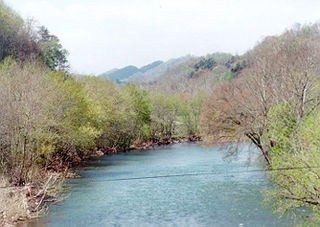
The Clinch River is a river that flows southwest for more than 300 miles (480 km) through the Great Appalachian Valley in the U.S. states of Virginia and Tennessee, gathering various tributaries, including the Powell River, before joining the Tennessee River in Kingston, Tennessee.

<span class="mw-page-title-main">Norris Dam</span> Dam in Tennessee, United States

Norris Dam is a hydroelectric and flood control structure located on the Clinch River in Anderson County and Campbell County, Tennessee, United States. The dam was the first major project for the Tennessee Valley Authority, which had been created in 1933 to bring economic development to the region and control the rampant flooding that had long plagued the Tennessee Valley. The dam was named in honor of Nebraska Senator George Norris (1861–1944), a longtime supporter of government-owned utilities in general, and supporter of TVA in particular. The infrastructure project was listed on the National Register of Historic Places in 2016.

<span class="mw-page-title-main">Bean Station, Tennessee</span> Lakeside town in Grainger and Hawkins counties, Tennessee

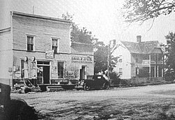
Bean Station is a town in Grainger and Hawkins counties in the state of Tennessee, United States. As of the 2020 census, the population was 2,967.

<span class="mw-page-title-main">Melton Hill Dam</span> Dam in Tennessee and Lenoir City, Tennessee

Melton Hill Dam is a hydroelectric dam on the Clinch River just south of Oak Ridge, Tennessee, United States. The dam is operated by the Tennessee Valley Authority, which built the dam in the early 1960s to extend the Tennessee Valley's continuous navigation channel up the Clinch as far as Clinton and to increase TVA's overall power-generating capacity. The dam impounds the 5,470-acre (2,210 ha) Melton Hill Lake, and is the only TVA tributary dam serviced by a navigation lock. The dam and associated infrastructure were listed on the National Register of Historic Places in 2017.

<span class="mw-page-title-main">Museum of Appalachia</span> Museum in Norris, Tennessee

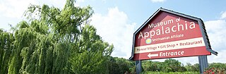
The Museum of Appalachia, located in Norris, Tennessee, 20 miles (32 km) north of Knoxville, is a living history museum that interprets the pioneer and early 20th-century period of the Southern Appalachian region of the United States. Recently named an Affiliate of the Smithsonian Institution, the museum is a collection of more than 30 historic buildings rescued from neglect and decay and gathered onto 63 acres (25 ha) of picturesque pastures and fields. The museum also preserves and displays thousands of authentic relics, maintains one of the nation's largest folk art collections, and hosts performances of traditional Appalachian music and annual demonstrations by hundreds of regional craftsmen.

<span class="mw-page-title-main">U.S. Route 25E</span> Highway in Tennessee and Kentucky, United States

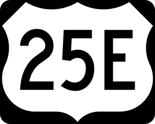
U.S. Route 25E (US 25E) is the eastern branch of US 25 from Newport, Tennessee, where US 25 splits into US 25E and US 25W, to North Corbin, Kentucky, where the two highways rejoin. The highway, however, continues as US 25E for roughly two miles (3.2 km) until it joins Interstate 75 (I-75) in the Laurel County community of North Corbin at exit 29. The highway serves the Appalachia regions of Kentucky's Cumberland Plateau and the Ridge-and-Valley section of East Tennessee, including the urbanized areas of Corbin and Middlesboro in Kentucky and Morristown in Tennessee.

<span class="mw-page-title-main">Norris Dam State Park</span> United States historic place

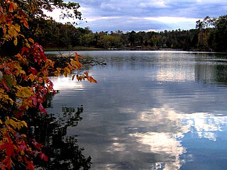
Norris Dam State Park is a state park in Anderson County and Campbell County, Tennessee, in the southeastern United States. The park is situated along the shores of Norris Lake, an impoundment of the Clinch River created by the completion of Norris Dam in 1936. The park consists of 4,038 acres (16.34 km2) managed by the Tennessee Department of Environment and Conservation. The park also administers the Lenoir Museum Complex, which interprets the area's aboriginal, pioneer, and early 20th-century history.

<span class="mw-page-title-main">Big Ridge State Park</span> State park in Tennessee, United States

Big Ridge State Park is a state park in Union County, Tennessee, in the southeastern United States. The park consists of 3,687 acres (14.92 km2) on the southern shore of the Norris Reservoir, an impoundment of the Clinch River created by the completion of Norris Dam in 1936. Much of the park's recreational focus is on Big Ridge Lake, a 45-acre (0.18 km2) sub-impoundment of Norris near the center of the park.

<span class="mw-page-title-main">Cove Lake State Park</span> State park in Tennessee, United States

Cove Lake State Park is a state park in Campbell County, Tennessee, in the southeastern United States. The park consists of 673 acres (2.72 km2) situated around Cove Lake, an impoundment of Cove Creek created by the completion of Caryville Dam in 1936. The park's location is in the town of Caryville and west of Jacksboro.

<span class="mw-page-title-main">Hazel Creek (Great Smoky Mountains)</span> River in North Carolina, United States

Hazel Creek is a tributary stream of the Little Tennessee River in the southwestern Great Smoky Mountains of North Carolina. The creek's bottomlands were home to several pioneer Appalachian communities and logging towns before its incorporation into the Great Smoky Mountains National Park. Hazel Creek is now a back country campsite and historical area.

<span class="mw-page-title-main">Rhea Springs, Tennessee</span> Community once located along the Piney River in Rhea County, Tennessee

Rhea Springs was a community once located along the Piney River in Rhea County, Tennessee, in the southeastern United States. Originally established in the 19th century as a health resort, the community was inundated when the completion of Watts Bar Dam by the Tennessee Valley Authority flooded the lower Piney Valley in 1942.

<span class="mw-page-title-main">U.S. Route 441 in Tennessee</span> U.S. Highway in Tennessee

U.S. Route 441 stretches for 83.28 miles (134.03 km) through the mountains of East Tennessee, connecting Rocky Top with Knoxville, Sevierville, Gatlinburg, and the Great Smoky Mountains National Park, crossing into North Carolina at Newfound Gap. Near its northern terminus, US 441 crosses over Norris Dam and passes through Norris Dam State Park.

Sharps Chapel is an unincorporated community in southwestern Union County, Tennessee, along the northern shore of Norris Lake.

<span class="mw-page-title-main">Poor Valley Creek State Park</span> Cancelled state park in Hawkins County, Tennessee

Poor Valley Creek State Park was a proposed state park in western Hawkins County, Tennessee, United States. It would have been located prominently near the Poor Valley Creek embayment of Cherokee Lake, an impoundment of the Holston River. The park was first planned in 1945, and shelved indefinitely following comments supporting "no action" on the project by state agencies in 1976.

References

  1. 1 2 "Loyston Sea". Tennessee River Valley. Retrieved June 3, 2021.
  2. 1 2 U.S. Geological Survey Geographic Names Information System: Loyston, Tennessee
  3. Union County Archived 2008-10-10 at the Wayback Machine , Tennessee History for Kids, Inc. website
  4. 1 2 3 4 5 6 7 Michael McDonald and John Muldowny, Tennessee Valley Perspectives, vol. 2, no. 3 (Spring 1972), pp. 23-27.
  5. "Lost Town of Loyston". COMMUNITY UPROOTED: EMINENT DOMAIN IN THE U.S. Loyola University Chicago . Retrieved June 3, 2021.
  6. Loyston Overlook Trail description, Big Ridge State Park website, accessed October 11, 2008
  7. Union County Historical Society, "Sharp's Fort Archived 2008-05-05 at the Wayback Machine ." 1999. Retrieved: 23 October 2008.
  8. Noble Thompson, A Geographic Appraisal of Union County, Tennessee (Tennessee Technological University, 1965), 5-8, 16.
  9. Union County Tennessee Post Offices and Postmasters Archived 2010-06-20 at the Wayback Machine , Union County GenWeb website, accessed October 11, 2008
  10. Information obtained from CCC monument near the entrance to Big Ridge State Park, 18 October 2008.
  11. Tennessee Valley Authority, The Norris Project (Washington, D.C.: U.S. Government Printing Office, 1940), 531-532.
  12. Tennessee Valley Authority (1940). The Norris Project: A Comprehensive Report on the Planning, Design, Construction, and Initial Operations of the Tennessee Valley Authority's First Water Control Project. U.S. Government Printing Office. Retrieved June 3, 2021.
  13. Bob Fowler, Museum to preserve Loyston playhouse Archived 2011-07-13 at the Wayback Machine , Knoxville News Sentinel, August 11, 2008