
Lulu Town, also known as Lulu Ville, is a now uninhabited, former settlement on Navassa Island, claimed by both the United States and neighbouring Haiti, in the Windward Passage.
Lulu Town, also known as Lulu Ville, is a now uninhabited, former settlement on Navassa Island, claimed by both the United States and neighbouring Haiti, in the Windward Passage.
Navassa Island was claimed for the United States on September 19, 1857, by Peter Duncan, an American sea captain, under the Guano Islands Act of August 18, 1856. [1] The modest settlement was created to house both mine workers and supervisors whose goal was the rich deposits of guano found on Navassa. This resource, gathered mainly from the interior of the island, was stored in Lulu Town for later shipment to the United States. [2]
Mining operations on Navassa Island were halted and the island evacuated in 1899 during the Spanish–American War. In 1901 the Navassa Phosphate Co. filed for bankruptcy and abandoned Lulu Town and rest of the island. [3]
The town lies on Lulu Bay. Its ruggedness prevents boats from landing; such small boats as regularly ply the area are mainly fishing boats from nearby Haiti. [4]

Baker Island, formerly known as New Nantucket, is an uninhabited atoll just north of the Equator in the central Pacific Ocean about 3,090 km (1,920 mi) southwest of Honolulu. The island lies almost halfway between Hawaii and Australia. Its nearest neighbor is Howland Island, 42 mi (68 km) to the north-northwest; both have been claimed as territories of the United States since 1857, though the United Kingdom considered them part of the British Empire between 1897 and 1936.
Howland Island is an uninhabited coral island located just north of the equator in the central Pacific Ocean, about 1,700 nautical miles (3,100 km) southwest of Honolulu. The island lies almost halfway between Hawaii and Australia and is an unorganized, unincorporated territory of the United States. Together with Baker Island it forms part of the Phoenix Islands. For statistical purposes, Howland is grouped as one of the United States Minor Outlying Islands. The island has an elongated cucumber-shape on a north–south axis, 1.40 by 0.55 miles, and covers 1 square mile.

Jarvis Island is an uninhabited 4.5 km2 (1.7 sq mi) coral island located in the South Pacific Ocean, about halfway between Hawaii and the Cook Islands. It is an unincorporated, unorganized territory of the United States, administered by the United States Fish and Wildlife Service of the United States Department of the Interior as part of the National Wildlife Refuge system. Unlike most coral atolls, the lagoon on Jarvis is wholly dry.

Kingman Reef is a largely submerged, uninhabited, triangle-shaped reef, geologically an atoll, 9.0 nmi (20 km) east-west and 4.5 nmi (8 km) north-south, in the North Pacific Ocean, roughly halfway between the Hawaiian Islands and American Samoa. It has an area of 3 hectares and is one of the unincorporated territories of the United States in Oceania. The reef is administered by the United States Fish and Wildlife Service as the Kingman Reef National Wildlife Refuge.

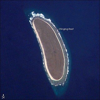
Navassa Island is a small uninhabited island in the Caribbean Sea. Located northeast of Jamaica, south of Cuba, and 40 nautical miles west of Jérémie on the Tiburon Peninsula of Haiti, it is subject to an ongoing territorial dispute between Haiti and the United States, which administers the island through the U.S. Fish and Wildlife Service.

The United States Minor Outlying Islands is a statistical designation defined by the International Organization for Standardization's ISO 3166-1 code. The entry code is ISO 3166-2:UM. The minor outlying islands and groups of islands consist of eight United States insular areas in the Pacific Ocean and one in the Caribbean Sea.
In the law of the United States, an insular area is a U.S.-associated jurisdiction that is not part of the 50 states or the District of Columbia. This includes fourteen U.S. territories administered under U.S. sovereignty, as well as three sovereign states each with a Compact of Free Association with the United States. The term also may be used to refer to the previous status of the Philippine Islands and the Trust Territory of the Pacific Islands when it existed.

The Guano Islands Act is a United States federal law passed by the Congress that enables citizens of the United States to take possession in the name of the United States of unclaimed islands containing guano deposits. The islands can be located anywhere, so long as they are not occupied by citizens of another country and not within the jurisdiction of another government. It also empowers the president to use the military to protect such interests and establishes the criminal jurisdiction of the United States in these territories.

Ducie Island is an uninhabited atoll in the Pitcairn Islands. It lies east of Pitcairn Island, and east of Henderson Island, and has a total area of 1.5 square miles (3.9 km2), which includes the lagoon. It is 1.5 miles (2.4 km) long, measured northeast to southwest, and about 1 mile (1.6 km) wide. The island is composed of four islets: Acadia, Pandora, Westward and Edwards.

Nukunonu is the largest atoll within Tokelau, a dependency of New Zealand, in the south Pacific Ocean. It comprises 30 islets surrounding a central lagoon, with about 5.5 km2 (2.1 sq mi) of land area and a lagoon surface area of 109 km2 (42 sq mi). Motuhaga is the only islet that has inhabitants. It has an estimated population of 448.
The Alto Velo Claim, also referred to as the Alta Vela Affair, was a territorial claim against the Dominican government by American adventurers ejected from Alto Velo Island by Dominican officials in October 1860. In all, three companies claimed U.S. protection of their right to mine guano from the island under the Guano Islands Act of 1856, but the U.S. Department of State never recognized U.S. interests in the island.
The United States Miscellaneous Caribbean Islands is an obsolete collective term for the territories currently or formerly controlled by the United States in the Caribbean Sea. Most of the islands were acquired through claims made via the Guano Islands Act:
While the United States has relatively complicated maritime boundaries, it shares international land borders with only two nations:
Guano is the accumulated excrement of seabirds or bats. Guano is a highly effective fertilizer due to the high content of nitrogen, phosphate, and potassium, all key nutrients essential for plant growth. Guano was also, to a lesser extent, sought for the production of gunpowder and other explosive materials.
Alto Velo Island is a small uninhabited island south of the island of Hispaniola in the Caribbean Sea. Its maximum height is about 152 metres (499 ft) above sea level. It lies on an underwater mountain range which continues to Beata Island and the southwestern coast of the Dominican Republic. It has an area of 1.02 km2 (0.39 sq mi) and is 1.4 km (0.87 mi) long, being oval in shape.

Navassa Island Light is a deactivated lighthouse on Navassa Island, which lies in the Caribbean Sea at the south end of the Windward Passage between the islands of Hispaniola to the east and Cuba and Jamaica to the west. It is on the shortest route between the east coast of the United States and the Panama Canal. The light was built in 1917 and deactivated in 1996. The light is gradually deteriorating from lack of maintenance. The keepers' house is roofless and in ruins.
The United States has the world's largest exclusive economic zone, before France. The total size is 11,351,000 km2 (4,383,000 sq mi)2. Areas of its EEZ are located in three oceans, the Gulf of Mexico, and the Caribbean Sea. Most notable areas are Alaska, Hawaii, the East Coast, West Coast and Gulf Coast of the United States.
Jones v. United States 137 U.S. 202 (1890) is a United States Supreme Court case in which the court upheld the constitutionality of the Guano Islands Act, which states that any island that fell under the act was under the jurisdiction of any existing statues or laws pertaining to high seas. The case originated from claims the United States government could not prosecute Henry Jones for committing murder on Navassa Island during a riot.