Luthersville, Georgia

Last updated

Luthersville, Georgia
City
LUTHERSVILLE, GEORGIA.jpg
Luthersville in 2013
Meriwether County Georgia Incorporated and Unincorporated areas Luthersville Highlighted.svg
Location in Meriwether County and the state of Georgia
Coordinates: 33°12′33″N84°44′43″W / 33.20917°N 84.74528°W / 33.20917; -84.74528
CountryUnited States
State Georgia
County Meriwether
Area
[1]
  Total3.19 sq mi (8.25 km2)
  Land3.16 sq mi (8.19 km2)
  Water0.02 sq mi (0.06 km2)
Elevation
942 ft (287 m)
Population
 (2020) [2]
  Total776
  Density245.26/sq mi (94.70/km2)
Time zone UTC-5 (Eastern (EST))
  Summer (DST) UTC-4 (EDT)
ZIP code
30251
Area code 770
FIPS code 13-48008 [3]
GNIS feature ID0317494 [4]

Luthersville is a city in Meriwether County, Georgia, United States. The population was 776 at the 2020 census, [2] down from 874 in 2010.

Contents

History

The Georgia General Assembly incorporated Luthersville as a town in 1872. [5] The community was named after the 16th-century German reformer Martin Luther. [6]

Geography

Luthersville is located in northern Meriwether County at 33°12′33″N84°44′43″W / 33.20917°N 84.74528°W / 33.20917; -84.74528 (33.209299, −84.745286). [7] Its northern border is the Coweta County line. U.S. Route 27 Alternate is Luthersville's Main Street; the highway leads south 13 miles (21 km) to Greenville, the Meriwether county seat, and north 12 miles (19 km) to Newnan. Georgia State Route 54 crosses US 27 Alternate in the center of Luthersville; it leads northeast 11 miles (18 km) to Turin and southwest the same distance to Hogansville.

According to the United States Census Bureau, Luthersville has a total area of 3.2 square miles (8.3 km2), of which 0.02 square miles (0.05 km2), or 0.72%, are water. [1] The city sits on a ridge that forms the divide between the Chattahoochee River watershed to the west and the Flint River watershed to the east. The northwest part of the city drains to Yellowjacket Creek, a tributary of the Chattahoochee, while the southern part of the city drains to Coleman Creek and the northeast part drains to Bear Creek, both tributaries of the Flint.

Demographics

Historical population
CensusPop.Note
1880 179
1900 209
1910 34967.0%
1920 3592.9%
1930 321−10.6%
1940 35410.3%
1950 312−11.9%
1960 282−9.6%
1970 40041.8%
1980 59749.3%
1990 74124.1%
2000 7835.7%
2010 87411.6%
2020 776−11.2%
U.S. Decennial Census [8]
Luthersville racial composition as of 2020 [9]
RaceNum.Perc.
White (non-Hispanic)34143.94%
Black or African American (non-Hispanic)38749.87%
Native American 20.26%
Asian 81.03%
Other/Mixed 172.19%
Hispanic or Latino 212.71%

As of the 2020 United States census, there were 776 people, 248 households, and 173 families residing in the city.

Related Research Articles

<span class="mw-page-title-main">Taylor County, Georgia</span> County in Georgia, United States

Taylor County is a county located in the west central portion of the U.S. state of Georgia. As of the 2020 census, the population was 7,816. The county seat and largest city is Butler.

<span class="mw-page-title-main">Talbot County, Georgia</span> County in Georgia, United States

Talbot County is a county located in the west central portion of the U.S. state of Georgia. The 2020 census showed a population of 5,733. The county seat and largest city is Talbotton.

<span class="mw-page-title-main">Spalding County, Georgia</span> County in Georgia, United States

Spalding County is a county located in the west central portion of the U.S. state of Georgia. As of the 2020 census, the population was 67,306. The county seat is Griffin. The county was created December 20, 1851 and named for former United States representative and senator Thomas Spalding.

<span class="mw-page-title-main">Pike County, Georgia</span> County in Georgia, United States

Pike County is a county located in the west central portion of the U.S. state of Georgia. As of the 2020 census, the population was 18,889. The county seat is Zebulon.

<span class="mw-page-title-main">Meriwether County, Georgia</span> County in Georgia, United States

Meriwether County is a county located in the west central portion of the U.S. state of Georgia. As of the 2020 census, the population was 20,613. The county seat is Greenville, home of the Meriwether County Courthouse. The county was formed on December 14, 1827, as the 73rd county in Georgia. It was named for David Meriwether, a general in the American Revolutionary War and member of Congress from Georgia.

<span class="mw-page-title-main">Coweta County, Georgia</span> County in Georgia, United States

Coweta County is a county located in the west central portion of the U.S. state of Georgia. It is part of Metro Atlanta. As of the 2020 census, the population was 146,158. The county seat is Newnan.

<span class="mw-page-title-main">Allentown, Georgia</span> City in Georgia, United States

Allentown is a city in Bleckley, Laurens, Twiggs, and Wilkinson counties in the U.S. state of Georgia, primarily in Wilkinson County. As of the 2010 census, the city had a population of 169, down from 287 at the 2000 census. In 2020, its population was 195. The Twiggs County portion is part of the Macon metropolitan statistical area, while the Laurens County portion is part of the Dublin micropolitan statistical area. The remaining Wilkinson and Bleckley County portions are not part of any metropolitan or micropolitan area.

<span class="mw-page-title-main">Aldora, Georgia</span> Town in Georgia, United States

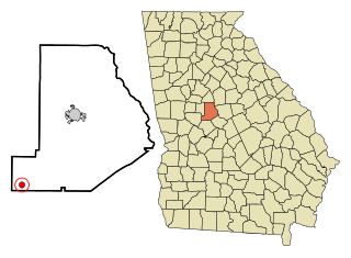
Aldora is a town in Lamar County, Georgia, United States. As of the 2020 census, the city had a recorded population of 0, due to a "0 percent self-response rate" to the 2020 census. The actual population was estimated at 103.

<span class="mw-page-title-main">Barnesville, Georgia</span> City in Georgia, United States

Barnesville is a city in Lamar County, Georgia, United States. As of the 2010 census, the city had a population of 6,755, up from 5,972 at the 2000 census. The city is the county seat of Lamar County and is part of the Atlanta metropolitan area.

<span class="mw-page-title-main">Milner, Georgia</span> City in Georgia, United States

Milner is a city in Lamar County, Georgia, United States. The population was 610 at the 2010 census, up from 522 at the 2000 census. Milner is part of Metro Atlanta.

<span class="mw-page-title-main">Smithville, Georgia</span> City in Georgia, United States

Smithville is a city in Lee County, Georgia, United States. The population was 593 in 2020. It is part of the Albany, Georgia metropolitan statistical area.

<span class="mw-page-title-main">Buena Vista, Georgia</span> City in Georgia, United States

Buena Vista is a city in Marion County, Georgia, United States. It is part of the Columbus, Georgia-Alabama metropolitan statistical area. The population was 1,585 at the 2020 census, down from 2,173 in 2010. Formerly known as "Pea Ridge", the city changed its name to Buena Vista in honor of Zachary Taylor's victory in the Mexican–American War. The city is the county seat of Marion County. It is the birthplace of baseball legend Josh Gibson and Medal of Honor recipient Luther H. Story.

<span class="mw-page-title-main">Greenville, Georgia</span> City in Georgia, United States

Greenville is a city and the county seat of Meriwether County, Georgia, United States. The population was 794 at the 2020 census, down from 876 in 2010. The city is located 60 miles (97 km) southwest of Atlanta and is part of the Atlanta metropolitan area.

<span class="mw-page-title-main">Lone Oak, Georgia</span> Town in Georgia, United States

Lone Oak is a town in Meriwether County, Georgia, United States. The population was 114 at the 2020 census.

<span class="mw-page-title-main">Manchester, Georgia</span> City in Georgia, United States

Manchester is a town in Meriwether and Talbot counties in the U.S. state of Georgia, although primarily in Meriwether. The population was 3,584 at the 2020 census, down from 4,230 in 2010. It is the most populous community in Meriwether County. CSX Transportation runs a railroad yard in Manchester.

<span class="mw-page-title-main">Warm Springs, Georgia</span> City in the United States

Warm Springs is a city in Meriwether County, Georgia, United States. The population was 465 at the 2020 census.

<span class="mw-page-title-main">Woodbury, Georgia</span> City in Georgia, United States

Woodbury is a city in Meriwether County, Georgia, United States. The population was 908 at the 2020 census.

<span class="mw-page-title-main">Culloden, Georgia</span> City in Georgia, United States

Culloden is a city in Monroe County, Georgia, United States. The population was 200 in the 2020 census. It is part of the Macon metropolitan statistical area.

<span class="mw-page-title-main">Forsyth, Georgia</span> City in Georgia, United States

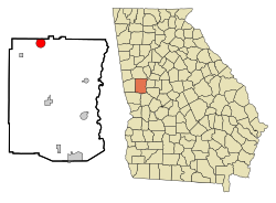
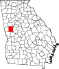
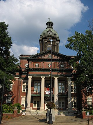
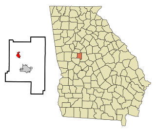
Forsyth is a city in and the county seat of Monroe County, Georgia, United States. The population was 4,384 at the 2020 census, up from 3,788 in 2010. Forsyth is part of the Macon metropolitan statistical area.

Beechmont is a census-designated place and unincorporated community in Muhlenberg County, Kentucky, United States. As of the 2020 census, the population was 776, up from 689 in 2010. The Beechmont post office is located at 3736 Merle Travis Highway.

References

  1. 1 2 "2022 U.S. Gazetteer Files: Georgia". United States Census Bureau. Retrieved January 24, 2023.
  2. 1 2 "P1. Race – Luthersville city, Georgia: 2020 DEC Redistricting Data (PL 94-171)". U.S. Census Bureau. Retrieved January 24, 2023.
  3. "U.S. Census website". United States Census Bureau . Retrieved January 31, 2008.
  4. "US Board on Geographic Names". United States Geological Survey. October 25, 2007. Retrieved January 31, 2008.
  5. "Luthersville, Georgia". meriwethercountychamber. Retrieved March 14, 2019.
  6. Krakow, Kenneth K. (1975). Georgia Place-Names: Their History and Origins (PDF). Macon, GA: Winship Press. p. 138. ISBN   0-915430-00-2.
  7. "US Gazetteer files: 2010, 2000, and 1990". United States Census Bureau. February 12, 2011. Retrieved April 23, 2011.
  8. "Census of Population and Housing". Census.gov. Retrieved June 4, 2015.
  9. "Explore Census Data". data.census.gov. Retrieved December 14, 2021.