Lynxville, Wisconsin

Last updated

Lynxville, Wisconsin
Lynxville, Wisconsin-2.jpg
Upper Mississippi, BNSF, and Wis-35 on the west side
Crawford County Wisconsin Incorporated and Unincorporated areas Lynxville Highlighted.svg
Location of Lynxville in Crawford County, Wisconsin.
Coordinates: 43°14′51″N91°3′14″W / 43.24750°N 91.05389°W / 43.24750; -91.05389
Country Flag of the United States.svg  United States
State Flag of Wisconsin.svg  Wisconsin
County Crawford
Area
[1]
  Total1.37 sq mi (3.54 km2)
  Land1.35 sq mi (3.51 km2)
  Water0.01 sq mi (0.04 km2)
Elevation
[2]
636 ft (194 m)
Population
 (2010) [3]
  Total132
  Estimate 
(2019) [4]
127
  Density93.87/sq mi (36.23/km2)
Time zone UTC-6 (Central (CST))
  Summer (DST) UTC-5 (CDT)
Area code 608
FIPS code 55-46675 [5]
GNIS feature ID1568849 [2]

Lynxville is a village in Crawford County, Wisconsin, United States. The population was 132 at the 2010 census.

Contents

History

The village was named for the ship Lynx which brought the first surveyors to the area. [6] Mitchel Caya was the first resident of Lynxville in 1848. [7]

Geography

Lynxville is located at 43°14′51″N91°3′14″W / 43.24750°N 91.05389°W / 43.24750; -91.05389 (43.247540, -91.053911). [8]

According to the United States Census Bureau, the village has a total area of 1.36 square miles (3.52 km2), of which, 1.35 square miles (3.50 km2) of it is land and 0.01 square miles (0.03 km2) is water. [9]

Climate

Climate data for Lynxville, Wisconsin (Lock and Dam No. 9) (1991–2020 normals, extremes 1939–present)
MonthJanFebMarAprMayJunJulAugSepOctNovDecYear
Record high °F (°C)57
(14)
70
(21)
82
(28)
93
(34)
94
(34)
100
(38)
101
(38)
101
(38)
100
(38)
92
(33)
75
(24)
66
(19)
101
(38)
Mean daily maximum °F (°C)26.6
(−3.0)
31.4
(−0.3)
44.0
(6.7)
58.3
(14.6)
70.1
(21.2)
79.1
(26.2)
82.5
(28.1)
80.1
(26.7)
73.3
(22.9)
59.9
(15.5)
44.4
(6.9)
31.6
(−0.2)
56.8
(13.8)
Daily mean °F (°C)18.1
(−7.7)
22.2
(−5.4)
34.6
(1.4)
47.8
(8.8)
59.4
(15.2)
68.9
(20.5)
72.8
(22.7)
70.7
(21.5)
63.3
(17.4)
50.5
(10.3)
36.5
(2.5)
24.3
(−4.3)
47.4
(8.6)
Mean daily minimum °F (°C)9.6
(−12.4)
13.1
(−10.5)
25.3
(−3.7)
37.3
(2.9)
48.7
(9.3)
58.7
(14.8)
63.1
(17.3)
61.3
(16.3)
53.3
(11.8)
41.1
(5.1)
28.6
(−1.9)
17.0
(−8.3)
38.1
(3.4)
Record low °F (°C)−43
(−42)
−34
(−37)
−34
(−37)
11
(−12)
27
(−3)
36
(2)
46
(8)
44
(7)
29
(−2)
18
(−8)
−8
(−22)
−29
(−34)
−43
(−42)
Average precipitation inches (mm)1.29
(33)
1.18
(30)
2.03
(52)
3.75
(95)
4.68
(119)
5.50
(140)
4.47
(114)
3.82
(97)
3.79
(96)
2.53
(64)
2.02
(51)
1.45
(37)
36.51
(927)
Average snowfall inches (cm)9.9
(25)
10.0
(25)
4.6
(12)
0.6
(1.5)
0.0
(0.0)
0.0
(0.0)
0.0
(0.0)
0.0
(0.0)
0.0
(0.0)
0.1
(0.25)
1.7
(4.3)
8.6
(22)
35.5
(90)
Average precipitation days (≥ 0.01 in)8.97.89.111.312.612.09.88.99.39.37.79.0115.7
Average snowy days (≥ 0.1 in)6.15.12.20.30.00.00.00.00.00.11.35.320.4
Source: NOAA [10] [11]

Demographics

Historical population
CensusPop.Note
1880 155
1890 24356.8%
1900 32232.5%
1910 274−14.9%
1920 253−7.7%
1930 230−9.1%
1940 2331.3%
1950 217−6.9%
1960 183−15.7%
1970 149−18.6%
1980 17416.8%
1990 153−12.1%
2000 17615.0%
2010 132−25.0%
2019 (est.)127 [4] −3.8%
U.S. Decennial Census [12]

2010 census

As of the census [3] of 2010, there were 132 people, 63 households, and 45 families living in the village. The population density was 97.8 inhabitants per square mile (37.8/km2). There were 101 housing units at an average density of 74.8 per square mile (28.9/km2). The racial makeup of the village was 98.5% White and 1.5% African American. Hispanic or Latino of any race were 3.8% of the population.

There were 63 households, of which 25.4% had children under the age of 18 living with them, 54.0% were married couples living together, 11.1% had a female householder with no husband present, 6.3% had a male householder with no wife present, and 28.6% were non-families. 27.0% of all households were made up of individuals, and 6.4% had someone living alone who was 65 years of age or older. The average household size was 2.10 and the average family size was 2.40.

The median age in the village was 52.7 years. 18.2% of residents were under the age of 18; 4.5% were between the ages of 18 and 24; 18.2% were from 25 to 44; 37.8% were from 45 to 64; and 21.2% were 65 years of age or older. The gender makeup of the village was 51.5% male and 48.5% female.

2000 census

As of the census [5] of 2000, there were 176 people, 76 households, and 56 families living in the village. The population density was 127.0 people per square mile (48.9/km2). There were 111 housing units at an average density of 80.1 per square mile (30.8/km2). The racial makeup of the village was 98.86% White, 0.57% Asian, and 0.57% from two or more races. Hispanic or Latino of any race were 1.70% of the population.

There were 76 households, out of which 22.4% had children under the age of 18 living with them, 57.9% were married couples living together, 13.2% had a female householder with no husband present, and 26.3% were non-families. 22.4% of all households were made up of individuals, and 7.9% had someone living alone who was 65 years of age or older. The average household size was 2.32 and the average family size was 2.63.

In the village, the population was spread out, with 17.6% under the age of 18, 6.3% from 18 to 24, 26.1% from 25 to 44, 35.8% from 45 to 64, and 14.2% who were 65 years of age or older. The median age was 45 years. For every 100 females, there were 107.1 males. For every 100 females age 18 and over, there were 98.6 males.

The median income for a household in the village was $30,833, and the median income for a family was $35,000. Males had a median income of $17,083 versus $18,333 for females. The per capita income for the village was $14,979. None of the families and 6.7% of the population were living below the poverty line, including no under eighteens and 9.5% of those over 64.

Transportation

Bus service towards La Crosse and Prairie du Chien is provided three times daily per direction by Scenic Mississippi Regional Transit. [13]

Notable people

Images

Related Research Articles

<span class="mw-page-title-main">Shoal Creek Estates, Missouri</span> Village in Missouri, United States

Shoal Creek Estates is a village in Newton County, Missouri, United States. The population was 76 at the 2010 census. It is part of the Joplin, Missouri Metropolitan Statistical Area.

<span class="mw-page-title-main">Coney Island, Missouri</span> Village in Missouri, United States

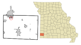
Coney Island is a village in Stone County, Missouri, United States. The population was 47 at the 2020 census. It is part of the Branson, Missouri Micropolitan Statistical Area.

<span class="mw-page-title-main">Stamford, Nebraska</span> Village in Nebraska, United States

Stamford is a village in Harlan County, Nebraska, United States. The population was 183 at the 2010 census.

<span class="mw-page-title-main">Encino, New Mexico</span> Village in New Mexico, United States

Encino is a village in Torrance County, New Mexico, United States. The population was 51 at the 2020 census. It is part of the Albuquerque Metropolitan Statistical Area.

<span class="mw-page-title-main">Midland, Ohio</span> Village in Ohio, United States

Midland is a village in Clinton County, Ohio, United States. The population was 307 at the 2020 census.

<span class="mw-page-title-main">Cuyahoga Heights, Ohio</span> Village in Ohio, United States

Cuyahoga Heights is a village in Cuyahoga County, Ohio, United States. The population was 573 at the 2020 census. A suburb of Cleveland, it is a part of the Cleveland metropolitan area.

<span class="mw-page-title-main">Ithaca, Ohio</span> Village in Ohio, United States

Ithaca is a village in Darke County, Ohio, United States. The population was 81 at the 2020 census.

<span class="mw-page-title-main">Union City, Ohio</span> Village in Ohio, United States

Union City is a village in Darke County, Ohio, United States. The population was 1,582 at the 2020 census. It is directly across the state line from its twin city of Union City, Indiana.

<span class="mw-page-title-main">North Fairfield, Ohio</span> Village in Ohio, United States

North Fairfield is a village in Huron County, Ohio, United States. The population was 465 at the 2020 census.

<span class="mw-page-title-main">Hartford, Ohio</span> Village in Ohio, United States

Hartford is a village in the township of the same name in Licking County, Ohio, United States. The population was 404 at the 2020 census.

<span class="mw-page-title-main">Corwin, Ohio</span> Village in Ohio, United States

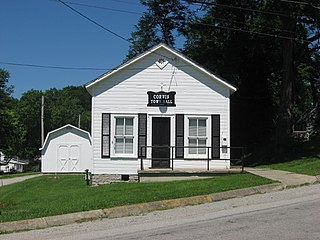
Corwin is a village in Wayne Township, Warren County, Ohio, United States. The population was 484 at the 2020 census.

<span class="mw-page-title-main">Pine Glen, Pennsylvania</span> Census-designated place in Pennsylvania, United States

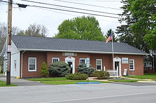
Pine Glen is an unincorporated community and census-designated place (CDP) in Centre County, Pennsylvania, United States. It is part of the State College, Pennsylvania Metropolitan Statistical Area. It is part of Burnside Township. The population was 190 at the 2010 census.

<span class="mw-page-title-main">Bellevue, Wisconsin</span> Village in Wisconsin, United States

Bellevue is a village in Brown County, Wisconsin. It was a town until incorporating as a village on February 14, 2003. The population was 15,935 at the time of the 2020 census. Bellevue is part of the Green Bay metropolitan area. Bellevue sits around 4.34 miles (6.99 km) east from central Green Bay.

<span class="mw-page-title-main">Avoca, Wisconsin</span> Village in Wisconsin, United States

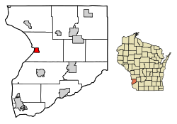
Avoca is a village in Iowa County, Wisconsin, United States. The population was 637 at the 2010 census. It is part of the Madison Metropolitan Statistical Area. It is named after Avoca in Ireland.

<span class="mw-page-title-main">Kellnersville, Wisconsin</span> Village in Wisconsin, United States

Kellnersville is a village in Manitowoc County, Wisconsin, United States. The population was 307 at the 2020 census.

<span class="mw-page-title-main">Halsey, Nebraska</span> Village in Blaine and Thomas counties in Nebraska, United States

Halsey is a village in Blaine and Thomas counties in Nebraska, United States. The population was 76 at the 2010 census.

<span class="mw-page-title-main">Buckeye Lake, Ohio</span> Village in Ohio, United States

Buckeye Lake is a village in Fairfield and Licking counties in the U.S. state of Ohio. The population was 2,520 at the 2020 census. It is named for Buckeye Lake, a large lake along which the village is built.

<span class="mw-page-title-main">Pulaski, Wisconsin</span> Village in Wisconsin, United States

Pulaski is a village in Brown, Oconto, and Shawano counties in the U.S. state of Wisconsin. The population was 3,539 at the 2010 census. Of this, 3,321 were in Brown County, 218 in Shawano County, and none in Oconto County.

<span class="mw-page-title-main">Wonewoc (town), Wisconsin</span> Town in Wisconsin, United States

Wonewoc is a town in Juneau County, Wisconsin, United States. The population was 783 at the 2000 census. The Village of Wonewoc and the village of Union Center are located within the town.

<span class="mw-page-title-main">Darien, Wisconsin</span> Village in Wisconsin, United States

Darien is a village in Walworth County, Wisconsin, United States. The population was 1,573 at the 2020 census. The village is located within the Town of Darien.

References

  1. "2019 U.S. Gazetteer Files". United States Census Bureau. Retrieved August 7, 2020.
  2. 1 2 "US Board on Geographic Names". United States Geological Survey. October 25, 2007. Retrieved January 31, 2008.
  3. 1 2 "U.S. Census website". United States Census Bureau . Retrieved November 18, 2012.
  4. 1 2 "Population and Housing Unit Estimates". United States Census Bureau. May 24, 2020. Retrieved May 27, 2020.
  5. 1 2 "U.S. Census website". United States Census Bureau . Retrieved January 31, 2008.
  6. Gannett, Henry (1905). The Origin of Certain Place Names in the United States. U.S. Government Printing Office. p.  193.
  7. "Crawford County, Wisconsin History - Chapter 35". Archived from the original on October 15, 2008. Retrieved October 3, 2010.
  8. "US Gazetteer files: 2010, 2000, and 1990". United States Census Bureau. February 12, 2011. Retrieved April 23, 2011.
  9. "US Gazetteer files 2010". United States Census Bureau. Archived from the original on January 25, 2012. Retrieved November 18, 2012.
  10. "NOWData - NOAA Online Weather Data". National Oceanic and Atmospheric Administration. Retrieved March 31, 2024.
  11. "Summary of Monthly Normals 1991-2020". National Oceanic and Atmospheric Administration. Retrieved March 31, 2024.
  12. "Census of Population and Housing". Census.gov. Retrieved June 4, 2015.
  13. Bus Schedule ridesmrt.com [ dead link ]