Related Research Articles

Macalester College is a private liberal arts college in Saint Paul, Minnesota. Founded in 1874, Macalester is exclusively an undergraduate four-year institution with an enrollment of 2,142 students in the fall of 2023. The college has Scottish roots and emphasizes internationalism and multiculturalism.

Douglas, on the South Side of Chicago, Illinois, is one of Chicago's 77 community areas. The neighborhood is named for Stephen A. Douglas, Illinois politician and Abraham Lincoln's political foe, whose estate included a tract of land given to the federal government. This tract later was developed for use as the Civil War Union training and prison camp, Camp Douglas, located in what is now the eastern portion of the Douglas neighborhood. Douglas gave that part of his estate at Cottage Grove and 35th to the Old University of Chicago. The Chicago 2016 Olympic bid planned for the Olympic Village to be constructed on a 37-acre (15 ha) truck parking lot, south of McCormick Place, that is mostly in the Douglas community area and partly in the Near South Side.

Minneapolis is officially defined by its city council as divided into 83 neighborhoods. The neighborhoods are historically grouped into 11 communities. Informally, there are city areas with colloquial labels. Residents may also group themselves by their city street suffixes: North, Northeast, South, and Southeast.

Manhattan Community Board 5 is a New York City community board, part of the local government apparatus of the city, with the responsibility for the neighborhoods of Midtown, Times Square, most of the Theater District, the Diamond District, the Garment District, Herald Square, Koreatown, NoMad, Murray Hill and the Flatiron District, all in the borough of Manhattan. It is bounded by 59th Street on the north, Eighth Avenue, 26th Street, the Avenue of the Americas on the west, 14th Street on the south, and Lexington Avenue on the east, excluding the area from 34th to 40th Streets between Madison and Lexington Avenues, and the area from 20th to 22nd Streets between Park Avenue South and Lexington Avenue/Irving Place.

Torresdale, also formerly known as Torrisdale, is a neighborhood in the Far Northeast section of Philadelphia, Pennsylvania, United States. Torresdale is located along the Delaware River between Holmesburg and Bensalem Township in neighboring Bucks County.
WMCN is a radio station broadcasting a variety format. Licensed to St. Paul, Minnesota, United States, the station serves the greater St. Paul area. The station is currently owned by Macalester College and run by students. The station has held the WMCN call sign since July 30, 1979.
The Villager, formerly the Highland Villager, is a Saint Paul, Minnesota newspaper. It was founded by Barry Prichard and Arnold Hed in 1953 as the Highland Villager, after Saint Paul's Highland Park neighborhood, and is the oldest community newspaper in the Twin Cities. It was the first paper to be distributed in both of the Twin Cities; Minneapolis and Saint Paul. In 2007 it absorbed a sister paper, Avenues.

Minnesota State Highway 51 is a 11.274-mile-long (18.144 km) highway in Minnesota, which runs from its intersection with State Highway 5 in Saint Paul and continues north to its northern terminus at its interchange with Interstate 694 / U.S. Highway 10 in Arden Hills.
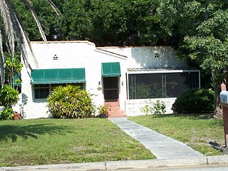
The Edgewood Historic District is a U.S. historic district located in Venice, Florida. The district is bounded by School Street, Myrtle Avenue, Venice-By-Way, and Groveland Avenue. It contains 36 historic buildings.

Community boards of Manhattan are New York City community boards in the borough of Manhattan, which are the appointed advisory groups of the community districts that advise on land use and zoning, participate in the city budget process, and address service delivery in their district.

Northeast Boundary is small neighborhood located in the northeast quadrant of Washington, D.C., in the United States. Along with the Capitol View neighborhood, it is the easternmost neighborhood of the District of Columbia.

Saint Paul, Minnesota, consists of 17 officially defined city districts or neighborhoods.

Erin Murphy is a Minnesota politician serving as Majority Leader of the Minnesota Senate since 2024. A member of the Minnesota Democratic–Farmer–Labor Party (DFL), she represents District 64, which includes the Highland Park, Macalester-Groveland, Merriam Park, Summit Hill, and St. Anthony Park, neighborhoods of the city of Saint Paul in Ramsey County in the Twin Cities metropolitan area. She is a former Majority Leader of the Minnesota House of Representatives, executive director of the Minnesota Nurses Association, and is also a registered nurse.
Macalester College Eco-House is one of the many specialty housing options available to students at Macalester College after their first year. The Eco-House is the project of Chris Wells, assistant professor of environmental studies, and began in fall 2007 with the move-in of four student residents. In the summer of 2007, prior to its opening, the Eco-House underwent significant "green" renovations in order to make the 1950s-era house livable and to decrease its environmental footprint.

The Metro A Line is a bus rapid transit line in the Twin Cities, Minnesota operated by Metro Transit. The A Line operates primarily along the Snelling Avenue corridor and travels through the cities of Minneapolis, Saint Paul, Falcon Heights, and Roseville. From the Blue Line in Minneapolis, the line travels past Minnehaha Park, through the Highland Village commercial area, past Macalester College, and connects to the Green Line near Allianz Field. The line continues through Saint Paul, past Hamline University, before traveling through Falcon Heights and Roseville, where the line passes the Minnesota State Fairgrounds, Har Mar Mall, and terminates at Rosedale Center.
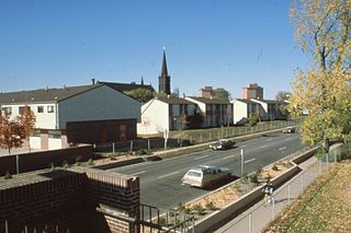
The Rondo neighborhood, or simply Rondo, is located within the officially designated Summit-University district in Saint Paul, Minnesota. The boundaries of the historically black neighborhood are sometimes referred to as Old Rondo. For much of the 20th century, Rondo was an important cultural and residential center of the black community in the Minneapolis–Saint Paul metropolitan region. The core of Old Rondo was demolished between 1956 and 1968, to make way for the construction of the Interstate 94 freeway. At least 650 families were displaced from the neighborhood, as well as many businesses and community locations. The neighborhood, although scarred by highway construction, remained a notable area in Saint Paul with a strong sense of cultural identity. Popular media and historians have the explored the impacts of highway construction and gentrification on Rondo residents past and present. In the 2000s, residents and public officials have discussed ways to reconnect the former community.

Snelling & Grand is a bus rapid transit station on the Metro A Line in Saint Paul, Minnesota.
Snelling & St. Clair is a bus rapid transit station on the Metro A Line in Saint Paul, Minnesota.
Snelling & Randolph is a bus rapid transit station on the Metro A Line in Saint Paul, Minnesota.
Little Earth is a residential housing area in Minneapolis, Minnesota, United States that is home to nearly 1,500 people, many of whom are Native American. The residential housing association at Little Earth considers itself a united people of 39 different Native American tribes, but the area is not an urban reservation, a common mischaracterization. Little Earth is located in the Phillips community of Minneapolis. While being a notable district, it is not one of the officially designated neighborhoods in the city.
References
- ↑ Macalester-Groveland Community Plan Retrieved February 2nd, 2024