The Madagascar subhumid forests ecoregion covers Madagascar's highlands, which extend north and south along the length of the island, above approximately 800 metres (2,600ft) elevation on the east and above 600 metres (2,000ft) meters elevation on the west.
The Central Highlands is the largest highland region on the island, extending from approximately 16º to 23º south. The Central Highlands include Ankaratra and the Andringitra Massif, which is home to Pic Boby (2,658 m), the Central Highlands' highest peak.[5]
The Northern Highlands includes the Tsaratanana Massif in the north, home to Maromokotro (2,876 m) Madagascar's highest peak, and the massifs of Marojejy to the northeast and Manongarivo to the northwest. It is separated from the Central Highlands by the Mandritsara Window, an east–west-running gap in the mountains with elevations below 800 meters.[5]
The Southern Highlands include the Anosyenne Mountains and adjacent uplands in the southern part of the island. It is separated from the Central Highlands by the Menaharaka Window, another gap below 800 meters elevation, at approximately 23°S latitude. The highest peak in the Southern Highlands is Pic d'Andohahela at 1,959 meters.[5]
The ecoregion includes some smaller outlying peaks, notably Montagne d'Ambre near the northern tip of Madagascar, the Makay Massif in west-central Madasgascar, and the Isalo and Analavelona massifs in the southwest of the island.[6]
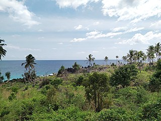
The subhumid forests extend to the northwest coast in the Sambirano region, including the island of Nosy Be. Most of that area is now covered by secondary grasslands and agriculture, with forest reduced to fragmented patches. The Sambirano region, also known as the Sambirano Domain, is a particular centre of endemism.[6]
The ecoregion has an area of approximately 199,600 square kilometers (77,100sqmi). The highlands catch the wet northeast trade winds, and the eastern slopes generally receive more rainfall. The ecoregion includes the headwaters of most of Madagascar's rivers, and wetlands like Lake Alaotra. Areas to the south, west, and north lie in the drier rain shadow of the highlands. The subhumid forests are bounded at lower elevations by the humid Madagascar lowland forests along the coastal strip to the east, by the Madagascar dry deciduous forests to the north and west, and by the sub-arid Madagascar succulent forests and Madagascar spiny thickets to the southwest and south. In four areas above 1,800–2,000 metres (5,900–6,600ft) elevation, the subhumid forests transition to the montane Madagascar ericoid thickets.[6]
Montagne d'Ambre near the northern tip of the island, contains a significant pocket of subhumid forest, surrounded at lower elevations by dry deciduous forest, as do Ankaratra, upland near Tsaratanana, Andringitra Massif, Ambohitantely Reserve, and the Ambohijanahary area. The subhumid forests ecoregion also includes the disjunct Analavelona and Isalo massifs to the southwest, surrounded by succulent forests at lower elevations.[6]
Flora
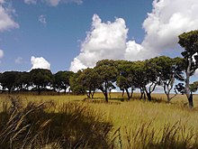
The ecoregion is home to several distinct plant communities, which differ with elevation, rainfall, and soils. These include moist montane forest, sclerophyllous montane forest, tapia forest, rupicolous shrubland, and grassland.[7]
The original flora of ecoregion has been much altered by human use; extensive areas have been cleared for agriculture, grazing, and rice cultivation, and some exotic species such as Acacia and Eucalyptus have been introduced. Moist evergreen forests are less susceptible to fire than the sclerophyll forests and ericoid thickets. Frequent human-set fires have transformed some of the ecoregion's former forests into savannas and grasslands.[8] Grassland now coves much of the highlands, but the extent to which the grasslands are the result of human intervention is still subject to debate.[6]
Sclerophyllous montane forest is low sclerophyllous (hard-leaved) forests and open-canopied woodlands from 1300 to 2000 meters elevation, dominated by small-leaved trees. The canopy is generally no higher than 10 to 13 meters, and can resemble a thicket. Common canopy trees include Dicoryphe viticoides, Tina isoneura, Razafimandimbisonia minor, and Baronia taratana. Gymnosperms, including species of Podocarpus, and bamboo can form pure stands. The trees and the ground are covered in mosses and lichens.[8]
Rupicolous shrubland grows on rock outcrops and sandstone and granite inselbergs. Vegetation grows in crevices and on thin mats of coarse soil, and is often sparse and rarely more than two meters high. Common plants include the sedge Coleochloa setifera, the shrub Myrothamnus moschata, and species of Euphorbia. The shrublands are home to many endemic species including succulents in the genera Aloe, Kalanchoe, and Pachypodium. Revivescent plants, which periodically dry out and then revive when rains return, include the moss-like Selaginella echinata and the fernsPellaea, Actiniopteris, and Notholaena. [8][9]
Sambirano forests. The Sambirano region, also known as the Sambirano Domain, is a coastal region of northwestern Madagascar, lying west of the Tsaratanana and Manongarivo massifs. The region has higher rainfall than the rest of the west coast, and is home to distinctive forests. The Sambirano forests are predominantly evergreen, with some deciduous species characteristic of the dry forests to the north and south, which form a mature canopy 25 to 30 meters high. The Sambirano forests are home to several endemic species of plants and animals.[10] Lowland primary forest has been reduced to small patches.
Secondary grasslands cover broad areas of the highlands. They are typically species–poor. 'Tanety' grasslands are low, sparse grasslands between 1,200 and 1,500 meters elevation, where Aristida rufescens is the characteristic species. 'Tampoketsa' grasslands cover the plateaus north and northeast of Antananarivo, between 1,600 and 1,900 meters elevation. The Madagascar endemic grass Loudetia simplex subsp. stipoides is predominant, interspersed with small patches of remnant forest. Low grasslands have also replaced most of the former tapia forests on the western slopes, between 800 and 1,600 meters elevation.[7]
Above 2000 meters the sclerophyll forests transition to the high-elevation ericoid thickets, which are considered a distinct subalpine ecoregion.
Endemic species include a number of birds, reptiles and mammals including the Alaotra gentle lemur (Hapalemur alaotrensis) and a number of shrews, tenrecs, and rodents. The subhumid forests were formerly home to the island's distinct megafauna, including giant lemurs, some of them larger than modern gorillas, the elephant birds (Aepyornithidae), and giant tortoises.[6]
Lake Alaotra and its wetlands were once home to two endemic water birds, the Madagascar pochard (Aythya innotata) and Alaotra grebe (Tachybaptus rufolavatus). Both have disappeared from the lake. The Alaotra grebe is thought extinct, and the Madagascar pochard was thought extinct until a small population was sighted at Lake Matsaborimena.
Two dry forest species, Coquerel's coua (Coua coquereli) and Schlegel's asity (Philepitta schlegeli) also inhabit the humid forests of Sambirano.[11]
Madagascar lost 44% of its original forest between 1953 and 2014.
The central highlands are the most densely populated region of Madagascar, and includes the country's capital and largest city, Antananarivo. The highlands' population is growing.
Madagascar's high plateau forests have been altered by humans in most places. There has been extensive slash-and-burn activity by native peoples in the central highlands, eliminating most forest. Other impacts include land clearing for agriculture, overexploitation, introduced species, and pollution.[6]
7.68% of the ecoregion is in protected areas. Protected areas include:[1]
The Madagascar lowland forests or Madagascar humid forests are a tropical moist broadleaf forest ecoregion found on the eastern coast of the island of Madagascar, home to a plant and animal mix that is 80 to 90% endemic, with the forests of the eastern plain being a particularly important location of this endemism. They are included in the Global 200 list of outstanding ecoregions.
The Madagascar ericoid thickets is a montane shrubland ecoregion, found at higher altitudes on Madagascar's four major mountains.
The Ethiopian Highlands is a rugged mass of mountains in Ethiopia in Northeast Africa. It forms the largest continuous area of its elevation in the continent, with little of its surface falling below 1,500 m (4,900 ft), while the summits reach heights of up to 4,550 m (14,930 ft). It is sometimes called the Roof of Africa due to its height and large area. Most of the Ethiopian Highlands are part of central and northern Ethiopia, and its northernmost portion reaches into Eritrea.
The Madagascar dry deciduous forests represent a tropical dry forest ecoregion situated in the western and northern part of Madagascar. The area has high numbers of endemic plant and animal species but has suffered large-scale clearance for agriculture. They are among the world's richest and most distinctive dry forests and included in the Global 200 ecoregions by the World Wide Fund. The area is also home to distinctive limestone karst formations known as tsingy, including the World Heritage Site of Bemaraha.
The Talamancan montane forests ecoregion, in the tropical moist broadleaf forest biome, are in montane Costa Rica and western Panama in Central America.
Isalo National Park is a National Park in the Ihorombe Region of Madagascar, in the southwestern corner of the Province of Fianarantsoa. The closest town is Ranohira, and the closest cities are Toliara and Ihosy. It is a sandstone landscape that has been dissected by wind and water erosion into rocky outcrops, plateaus, extensive plains and up to 200 m (660 ft) deep canyons. There are permanent rivers and streams as well as many seasonal watercourses. Elevation varies between 510 and 1,268 m.
Podocarpus rostratus is a species of conifer in the family Podocarpaceae. It is endemic to Madagascar.
For other localities with the same name, see Tsaratanana (disambiguation)
The Comoros forests is a terrestrial ecoregion which covers the Comoro Islands, which lie in the Mozambique Channel between Madagascar and East Africa. These include four main islands: Grande Comore, Anjouan and Mohéli, of the Union of the Comoros, and Mayotte, a department and region of France.
Northern Zanzibar–Inhambane coastal forest mosaic, also known as the Northern Swahili coastal forests and woodlands, is a tropical moist broadleaf forest ecoregion of coastal East Africa. The ecoregion includes a variety of habitats, including forest, savanna and swamps.
The Guinean montane forests are a tropical moist broadleaf forest ecoregion of West Africa.
The flora of Madagascar consists of more than 12,000 species of plants, as well as a poorly known number of fungi and algae. Around 83% of Madagascar's vascular plants are found only on the island. These endemics include five plant families, 85% of the over 900 orchid species, around 200 species of palms, and such emblematic species as the traveller's tree, six species of baobab and the Madagascar periwinkle. The high degree of endemism is due to Madagascar's long isolation following its separation from the African and Indian landmasses in the Mesozoic, 150–160 and 84–91 million years ago, respectively. However, few plant lineages remain from the ancient Gondwanan flora; most extant plant groups immigrated via across-ocean dispersal well after continental break-up.
The Ethiopian montane forests is a tropical moist broadleaf forest ecoregion in eastern Africa. It covers the middle elevations of the Ethiopian Highlands in Ethiopia and extends into neighboring Eritrea, Sudan, Djibouti, and Somaliland. The ecoregion includes distinctive Afromontane forests, woodlands, grasslands, and shrublands. The ecoregion's biodiversity is threatened by deforestation, conversion to agriculture, and overgrazing.
Uapaca bojeri, or tapia, is a tree species endemic to Madagascar. A characteristic element of the Madagascan flora, it occurs in the central highlands, where it dominates a type of sclerophyllous forest or woodland. Tapia forest has a high ecological value due to the fauna, flora, and funga it harbours, and is of economic interest to the local population, e.g. for collection of tapia fruits, firewood, mushrooms or wild silkworms, and hunting. Local impact through fire and cutting is seen as a form of sustainable use however tapia woodlands are now found only in scattered, isolated stands totaling at most 132,255 ha. Native woody vegetation of the central highlands is increasingly replaced by grasslands, primarily due to increased fire frequency as areas are burned annually.
The Madagascar succulent woodlands are a xeric shrublands ecoregion in southwestern and central western Madagascar. Native plants survive in the arid climate and long dry season with adaptations like succulent leaves, water storing trunks, photosynthetic stems, and dropping leaves during the dry season. The ecoregion is threatened by various human activities.
The Somali Acacia–Commiphora bushlands and thickets is a semi-arid tropical grasslands, savannas, and shrublands ecoregion in the Horn of Africa. It is home to diverse communities of plants and animals, including several endemic species.
Ephippiandra perrieri is a species of flowering plant endemic to the Northern Highlands of Madagascar.
Ephippiandra tsaratanensis is a species of flowering plant endemic to the Tsaratanana Massif of northern Madagascar.
Analavelona, also known as Analavelona Massif, is a mountain in southwestern Madagascar. The massif is home to an enclave of montane subhumid forest, which is considered a sacred forest by the local people and notable for its biodiversity.
The Sambirano region, also known as the Sambirano domain, is a biogeographic region of northwestern Madagascar. It has a distinctive lowland climate with year-round rain, differing from the rest of seasonally-dry western and northern Madagascar. The climate supports humid lowland rainforests, with greater similarity to those of eastern Madagascar than the dry deciduous forests characteristic of the Madagascar's western lowlands.
1 2 3 Everson, Kathryn M.; Jansa, Sharon A.; Goodman, Steven M.; Olson, Link E.. "Montane regions shape patterns of diversification in small mammals and reptiles from Madagascar’s moist evergreen forest". Journal of Biogeography, Oct 2020, Vol. 47 Issue 10, p2059-2072, 14p.
1 2 3 4 White, Frank F. (1983). The vegetation of Africa: A descriptive memoir to accompany the Unesco/AETFAT/UNSO vegetation map of Africa. UNESCO, 1983. ISBN 92-3-101955-4
1 2 3 4 5 Collins, N. Mark; Harcourt, Caroline S., Sayer, Jeffrey, Whitmore, T. C. (1992). The Conservation Atlas of tropical forests: Africa. Macmillan, London, 1992. ISBN 0-333-57757-4
↑ Burgess, Neil, Jennifer D’Amico Hales, Emma Underwood (2004). Terrestrial Ecoregions of Africa and Madagascar: A Conservation Assessment. Island Press, Washington DC.
↑ Wilme, Lucien (1996). "Composition and Characteristics of Bird Communities in Madagascar". Biogéographie de Madagascar, 1996: 349-362.
This page is based on this Wikipedia article Text is available under the CC BY-SA 4.0 license; additional terms may apply. Images, videos and audio are available under their respective licenses.