Data fusion

Magnetovision images may be used for data fusion with visual signal. This creates new possibility of presentation of magnetic field distribution for further analyses.
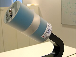
Magnetovision is the measuring technique enabling the visualization of magnetic field distribution in a given space.
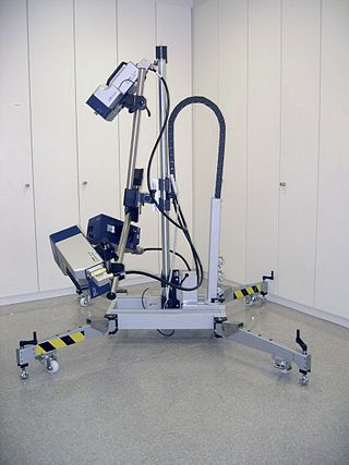
Magnetovision measuring stand consists of a magnetometer, X-Y or X-Y-Z movement mechanism and data processing and visualization system. Following modes of magnetovision signal acquisition are possible:
Typically, following types of sensors may be used:
There are different modes of magnetovision measurements. Measurements may be performed in 2D (X-Y) or 3D (X-Y-Z). Moreover, measurements of magnetic field may be absolute, differential or gradiometric.
Magnetovision may be used for:
Magnetovision images may be used for data fusion with visual signal. This creates new possibility of presentation of magnetic field distribution for further analyses.

A SQUID is a very sensitive magnetometer used to measure extremely subtle magnetic fields, based on superconducting loops containing Josephson junctions.

A magnetometer is a device that measures magnetic field or magnetic dipole moment. Different types of magnetometers measure the direction, strength, or relative change of a magnetic field at a particular location. A compass is one such device, one that measures the direction of an ambient magnetic field, in this case, the Earth's magnetic field. Other magnetometers measure the magnetic dipole moment of a magnetic material such as a ferromagnet, for example by recording the effect of this magnetic dipole on the induced current in a coil.

Magnetoencephalography (MEG) is a functional neuroimaging technique for mapping brain activity by recording magnetic fields produced by electrical currents occurring naturally in the brain, using very sensitive magnetometers. Arrays of SQUIDs are currently the most common magnetometer, while the SERF magnetometer is being investigated for future machines. Applications of MEG include basic research into perceptual and cognitive brain processes, localizing regions affected by pathology before surgical removal, determining the function of various parts of the brain, and neurofeedback. This can be applied in a clinical setting to find locations of abnormalities as well as in an experimental setting to simply measure brain activity.

A proton magnetometer, also known as a proton precession magnetometer (PPM), uses the principle of Earth's field nuclear magnetic resonance (EFNMR) to measure very small variations in the Earth's magnetic field, allowing ferrous objects on land and at sea to be detected.
An inductive sensor is a device that uses the principle of electromagnetic induction to detect or measure objects. An inductor develops a magnetic field when an electric current flows through it; alternatively, a current will flow through a circuit containing an inductor when the magnetic field through it changes. This effect can be used to detect metallic objects that interact with a magnetic field. Non-metallic substances, such as liquids or some kinds of dirt, do not interact with the magnetic field, so an inductive sensor can operate in wet or dirty conditions.

The Fast Auroral SnapshoT Explorer was a NASA plasma physics satellite, and was the second spacecraft in the Small Explorer program (SMEX). It was launched on 21 August 1996, from Vandenberg Air Force Base aboard a Pegasus XL launch vehicle. The spacecraft was designed and built by NASA's Goddard Space Flight Center (GSFC). Flight operations were handled by GSFC for the first three years, and thereafter were transferred to the University of California, Berkeley's Space Sciences Laboratory.
Geophysical survey is the systematic collection of geophysical data for spatial studies. Detection and analysis of the geophysical signals forms the core of Geophysical signal processing. The magnetic and gravitational fields emanating from the Earth's interior hold essential information concerning seismic activities and the internal structure. Hence, detection and analysis of the electric and Magnetic fields is very crucial. As the Electromagnetic and gravitational waves are multi-dimensional signals, all the 1-D transformation techniques can be extended for the analysis of these signals as well. Hence this article also discusses multi-dimensional signal processing techniques.

A proximity sensor is a sensor able to detect the presence of nearby objects without any physical contact.
Geophysical MASINT is a branch of Measurement and Signature Intelligence (MASINT) that involves phenomena transmitted through the earth and manmade structures including emitted or reflected sounds, pressure waves, vibrations, and magnetic field or ionosphere disturbances.
Magnetic immunoassay (MIA) is a type of diagnostic immunoassay using magnetic beads as labels in lieu of conventional enzymes (ELISA), radioisotopes (RIA) or fluorescent moieties to detect a specified analyte. MIA involves the specific binding of an antibody to its antigen, where a magnetic label is conjugated to one element of the pair. The presence of magnetic beads is then detected by a magnetic reader (magnetometer) which measures the magnetic field change induced by the beads. The signal measured by the magnetometer is proportional to the analyte concentration in the initial sample.
EMF measurements are measurements of ambient (surrounding) electromagnetic fields that are performed using particular sensors or probes, such as EMF meters. These probes can be generally considered as antennas although with different characteristics. In fact, probes should not perturb the electromagnetic field and must prevent coupling and reflection as much as possible in order to obtain precise results. There are two main types of EMF measurements:
Spacecraft attitude control is the process of controlling the orientation of a spacecraft with respect to an inertial frame of reference or another entity such as the celestial sphere, certain fields, and nearby objects, etc.

Magnetomyography (MMG) is a technique for mapping muscle activity by recording magnetic fields produced by electrical currents occurring naturally in the muscles, using arrays of SQUIDs. It has a better capability than electromyography for detecting slow or direct currents. The magnitude of the MMG signal is in the scale of pico (10−12) to femto (10−15) Tesla (T). Miniaturizing MMG offers a prospect to modernize the bulky SQUID to wearable miniaturized magnetic sensors.

A MEMSmagnetic field sensor is a small-scale microelectromechanical systems (MEMS) device for detecting and measuring magnetic fields (Magnetometer). Many of these operate by detecting effects of the Lorentz force: a change in voltage or resonant frequency may be measured electronically, or a mechanical displacement may be measured optically. Compensation for temperature effects is necessary. Its use as a miniaturized compass may be one such simple example application.
The scanning laser vibrometer or scanning laser Doppler vibrometer, was first developed by the British loudspeaker company, Celestion, around 1979, further developed in the 1980s, and commercially introduced by Ometron, Ltd around 1986. It is an instrument for rapid non-contact measurement and imaging of vibration.

The ISEE-1 was an Explorer-class mother spacecraft, International Sun-Earth Explorer-1, was part of the mother/daughter/heliocentric mission. ISEE-1 was a 340.2 kg (750 lb) space probe used to study magnetic fields near the Earth. ISEE-1 was a spin-stabilized spacecraft and based on the design of the prior IMP series of spacecraft. ISEE-1 and ISEE-2 were launched on 22 October 1977, and they re-entered on 26 September 1987.
Geophysical signal analysis is concerned with the detection and a subsequent processing of signals. Any signal which is varying conveys valuable information. Hence to understand the information embedded in such signals, we need to 'detect' and 'extract data' from such quantities. Geophysical signals are of extreme importance to us as they are information bearing signals which carry data related to petroleum deposits beneath the surface and seismic data. Analysis of geophysical signals also offers us a qualitative insight into the possibility of occurrence of a natural calamity such as earthquakes or volcanic eruptions.
This glossary of electrical and electronics engineering is a list of definitions of terms and concepts related specifically to electrical engineering and electronics engineering. For terms related to engineering in general, see Glossary of engineering.
In virtual reality (VR) and augmented reality (AR), a pose tracking system detects the precise pose of head-mounted displays, controllers, other objects or body parts within Euclidean space. Pose tracking is often referred to as 6DOF tracking, for the six degrees of freedom in which the pose is often tracked.

Dynamics Explorer 1 was a NASA high-altitude mission, launched on 3 August 1981, and terminated on 28 February 1991. It consisted of two satellites, DE-1 and DE-2, whose purpose was to investigate the interactions between plasmas in the magnetosphere and those in the ionosphere. The two satellites were launched together into polar coplanar orbits, which allowed them to simultaneously observe the upper and lower parts of the atmosphere.