Majene Regency (Indonesian: Kabupaten Majene) is one of the six regencies which comprise West Sulawesi Province, Indonesia, on the island of Sulawesi. The town of Majene in the far south of the regency is the administrative capital, and consists of two administrative districts - Banggae and Banggae Timur. The population of Majene Regency was 151,197 at the 2010 Census[2] and 174,407 at the 2020 Census;[3] the official estimate as at mid 2023 was 181,360 (comprising 90,641 males and 80,719 females).[1]
According to oral history of Mandar,[4] there were seven coastal Mandar kingdoms and seven inland Mandar kingdoms. The coastal kingdoms were Balanipa (now known as Tinambung), Sendana, Bangai (now known as Majene), Pamboang, Tapalan, Mamuju, and Binuang (now known as Polewali), while the inland kingdoms were Rantebulahan, Mambi, Arale, Tabulahan, Taban, Bambang, and Matanga.
The three kingdoms that occupied present day Majene Regency were Bangai, Pamboang (encompassing the sub-kingdom of Malunda), and Sendana. Peace was maintained among the seven coastal kingdoms by the "Pitu Ba'ba Binanga" Treaty, which essentially stated that the kingdoms had more to gain by living peacefully alongside each other than by warring for incidental gains in territory.[citation needed] The inland kingdoms also had a treaty known as "Pitu Uluna Salu", which also prevented warring amongst themselves.[citation needed]
The Dutch Era
It is said[who?] that the Mandar people were brave sailors who used their prowess on the sea to travel between Ternate and Singapore, safely shuttling spices and other rare commodities from destination to destination. Majene's strategic location as a remote "middle-ground" between the Spice Islands of Maluku and the Asian mainland made it an attractive target for Dutch intervention, which sought to intercept and monopolise the Maritime Southeast Asia trade routes.[citation needed]
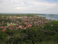
Sunset over Majene
In 1667, the Gowa Kingdom of South Sulawesi and the Dutch signed the Bungaya Treaty, which not only promised cooperation between the local South Sulawesi people and Dutch forces, but also stated that every kingdom that has an existing treaty with Gowa must also acknowledge the Bungaya Treaty. As regular traders with the Gowa Kingdom, the Mandar people would thus be submitting to the Dutch by default. However, when the Mandar kingdoms collectively refused to adhere to the provisions of this treaty, the Dutch chose to intervene with force.[citation needed]
As a result, in 1674, the Bone king Arung Palakka arrived in Majene with the Dutch to attack the Mandar kingdoms for their violation of the treaty. The Dutch could not defeat the Mandar people on their first attempt. All the kingdoms were united by this common enemy and were galvanized to share resources to defend the homeland.[citation needed] Traditional warfare in Majene was led by Daeng Rioso and Raja Bangai using traditional swords, keris daggers, and spears.
On their second attempt to gain control over West Sulawesi, the Dutch Republic orchestrated another treaty between the king of Bone and some of the Mandar kingdoms stating that the Mandar kingdoms could no longer enter in agreements and contracts with each other and instead must work entirely through the Bone Kingdom, which at the time was controlled by the Dutch. There was also a provision stating that if anyone attacked the Bone Kingdom, the Mandar kingdoms would rush to their aid and vice versa. The treaty was signed near Pinrang and sought to divide up the kingdoms and make them less of a threat. Though this treaty was immediately ineffective, it was the beginning of the unraveling of the Mandar kingdoms in the face of the Dutch.[citation needed]
The Bone treaty allowed the Dutch to conduct business with the Mandar people through the Bone intermediary, and as stipulated in the agreement, the Dutch did not interfere in governmental affairs of the Mandar people - though they did have a heavy influence on business and commerce. However, the treaty only proved to be only marginally effective in keeping the Mandar people at bay, and the Dutch realized that only total control over the region would lead to the most successful trade monopoly.[citation needed]
So, in their third and final attempt to weaken the Mandar kingdoms, the Dutch fell back on their time-tested "divide et impera" strategy and hired Indonesian spies to foment revolution and weaken the kings from the inside. Rumors were started, the royal governing parties became insulted (in many cases, over the alleged beauty of Mandar queens), and provocations ensued.[citation needed]
Then, in 1905, the Royal Netherlands East Indies Army arrived in full in Mandar territory, where they fought the Mandar people for two years until the natives surrendered in 1907. Strong Mandar leaders were jailed in Makassar at Fort Rotterdam and the Dutch occupation in the newly termed "Afdeling Mandar" began. The territory was supervised by a single Dutch Resident Assistant (Governor), who at the time also controlled the entire island of Sulawesi.[citation needed]
The sub-Afdeling (or county) territorial boundaries outlined by the Dutch still stand today and denote the difference between Majene, Polewali, Mamasa, and Mamuju. Each area was led by a Dutchman called the "controller". During this period, kings were still present and had some power, but they were largely just puppet kingdoms controlled entirely by the Dutch. Majene inhabitants remember the Dutch era as being particularly harsh – a time where their culture was stifled and even suffocated. Mandar people were enslaved, stripped of all rights, forced to work on Dutch projects, and generally treated very poorly. Moreover, the colonizers did not acknowledge any of the local languages spoken by the inhabitants of the Mandar kingdoms and denied them access to education.[citation needed]
The Japanese Era
The Dutch era was followed by the Japanese era during World War II. Between 1942 and 1943, the Japanese arrived in West Sulawesi and seized all territory under Dutch control after the Netherlands capitulated to Japan. The Japanese strategy for ridding Asia of all western occupiers was to win the hearts and support of the locals by assuming the role of the "older brother" and promising to act in the best of interests for Indonesia upon arrival.
Coconut shells drying in the sun
At the outset, the Japanese treated the Mandar people well. They offered them education, allowed them to speak their native language, and even trained the youth for war against the Allied Forces. Then, at the end of 1943, after they had gained their respect and trust, the Japanese forcibly took the land from the Mandar people as well as anything that was produced on it, effectively starving them and re-driving them into extreme poverty. Majenites say that in the transitional phase between occupations, they were passing "from the mouth of the crocodile to the mouth of the tiger". Many agree that the Asian occupation was far worse than the western one.
When the atomic bomb was dropped on Hiroshima and Nagasaki in 1945, the Japanese, having lost the war, left Sulawesi. Shortly thereafter, the Allied Forces (consisting mostly of Australians and Americans) arrived in 1946 to temporarily restore order and move the remaining Japanese troops to Baruga, an area just outside Mandar territory. The Dutch accompanied them as well, even though they weren't technically members of the Allied Forces, in an effort to use this chaotic opportunity to regain the influence they had lost at the hand of the Japanese. In effect, they were trying for the fourth time to control Mandar territory. Even though Indonesia was declared independent in 1945, the Mandar people continued to fight the Dutch in the Majene region until they accepted Indonesia's sovereignty in 1948.
Shortly before Indonesian National Revolution, there was a gathering of all of the coastal Mandar kings, where they all decided it was in their best interest to unite under the Indonesian Republic. The kings cooperated with the representatives sent from this new government and the kingdoms officially dissolved in 1948 when the global community finally acknowledged the sovereignty of Indonesia.
The kings still held the power in the kingdoms after the country became a republic, because it was not until 1961 that the Indonesian government fully formed the regional administrations, allowing the kings to remain the symbolic heads of their territories until that time. Royal familial blood lines can still be traced today and royal heritage is still coveted in society - less for political or authoritative roles and more for cultural ones instead. Furthermore, ceremonies such as weddings and Aqiqah communions for royal families are distinct from those for the non-royals.
A notable figure from Majene during this era was Baharuddin Lopa. Not only did he become the first Regent of Majene in 1959 at age 24, he would later go on to lead the struggle against corruption as district attorney during Soeharto Government. He became well known for his notable bravery and uncompromising stance on corruption during the early Reform era.
On January 15 2021, a magnitude 6.2 earthquake struck east of Majene. The earthquake caused extensive damage in the town, destroying many homes, buildings and schools. 108 people were killed and over 3,000 were injured, most of them in Majene and Mamuju.[5][6]
The Mandar people continue to be avid fishermen (catching mainly tuna, layang, cakalang, ikan terbang, tongkol, and kakap), talented sailors, competent farmers (farming predominantly cassava, rice, coconut, and bananas), dedicated silk-weavers (especially Mandar sarongs), and creative dancers (Pattudu Tomuane for males and Pattudu Towaine for Females). They are an extremely proud people and still insist that only people of Mandar tribal origin can hold high office in the region.[citation needed]
Cell phone and computer repair shops have sprung up in response to the various technological needs of the people and internet cafes (warnets) are quick to open as soon as Internet services become available.[citation needed]
Traditional Mandar wedding
Cacao production and exportation has experienced significant growth in the region in recent years.[which?]Philippine and Chinese investors plan on building micro-hydro powered cacao processing plants near Majene by 2011.[7] With this acceleration in cacao production, Governor of West Sulawesi Anwar Adnan Saleh is optimistic that the region will help Indonesia to become the world's largest cocoa producer and exporter. Indonesia is currently the world's third largest cocoa producer after Côte d'Ivoire and Ghana, contributing export earnings in excess of US$1.4 billion per year.[8]
In 2006, ExxonMobil began drilling offshore oil off the Majene Regency in Makassar Strait.[9] However by 2013, ExxonMobil returned Mandar Block to the government as it failed to find substantial oil after three exploration wells.[10]
Administration
The regency is divided into eight districts (kecamatan), tabulated below with their areas and their populations at the 2010 Census[2] and the 2020 Census,[3] together with the official estimates as at mid 2023.[1] The table also includes the locations of the district administrative centres, the number of villages in each district (a total of 62 rural desa and 20 urban kelurahan) in each district, and its post code.
Kode Wilayah
Name of District (kecamatan)
Area in km2
Pop'n Census 2010
Pop'n Census 2020
Pop'n Estimate mid 2023
Admin centre
No. of villages
Post code
76.05.01
Banggae
25.15
37,333
43,304
45,080
Totoli
8 (a)
81411 - 81415
76.05.08
Banggae Timur (East Banggae)
30.04
28,550
30,579
31,110
Labuang Utara (North Labuang)
9 (b)
81411 - 81414
76.05.02
Pamboang
70.19
20,800
24,087
25,070
Lalampanua
15 (c)
81451
76.05.03
Sendana (d)
82.24
20,374
24,299
25,550
Mosso Dhua
16 (e)
81452
76.05.06
Tammerodo Sendana
55.40
10,584
12,646
13,280
Tammerodo
7
81450
76.05.07
Tubo Sendana
41.17
8,214
9,759
10,230
Bonde Bonde
7
81455
76.05.04
Malunda
187.65
16,986
19,894
20,770
Malunda
12 (f)
81453
76.05.05
Ulumanda
456.00
8,266
9,839
10,320
Kabiraan
8
81454
Totals
947.84
151,107
174,407
181,360
Majene
82
Notes: (a) including the 6 urban villages (kelurahan) of Banggae, Baru, Galung, Pangali-Ali, Rangas and Totoli. (b) including the 8 urban villages of Baruga, Baruga Dhua, Baurung, Labuang, Labuang Utara, Lembang, Tande and Tande Timur. (c) including the 2 urban villages of Lalampanua and Sirindu. (d) includes the small offshore islands of Pulau Lereklerekan and Pulau Taimanu. (e) including the 2 urban villages of Mosso and Mosso Dhua. (f) including the 2 urban villages of Lamungang Batu and Malunda.
References
1 2 3 Badan Pusat Statistik, Jakarta, 28 February 2024, Kabupaten Majene Dalam Angka 2024 (Katalog-BPS 1102001.7605)
↑ Ahmad, Bapak; Marjanah, Dra (2007). Sejarah Mandar dan Sejarah Perjuangan Bangsa Di Kabupaten Majene. Majene: Dinas Pendidikan dan Kebudayaan Kabupaten Majene Bidang Binmudorabud Seksi Kebudayaan. p.150.
This page is based on this Wikipedia article Text is available under the CC BY-SA 4.0 license; additional terms may apply. Images, videos and audio are available under their respective licenses.