Malanje

Last updated
Malanje
Malanje Angoala, Rua poinero Zeca.JPG
Angola location map.svg
Red pog.svg
Malanje
Location in Angola
Coordinates: 9°32′S16°21′E / 9.533°S 16.350°E / -9.533; 16.350
CountryFlag of Angola.svg  Angola
Province Malanje Province
Area
  Total2,215 km2 (855 sq mi)
Elevation
1,155 m (3,789 ft)
Population
 (mid 2020) [1]
  Total604,215
  Density270/km2 (710/sq mi)
Time zone UTC+1 (WAT)
Climate Aw

Malanje is the capital city of Malanje Province in Angola, with a population of 455,000 (2014 census), [2] and a municipality, with a population of 506,847 (2014 census). Projected to be the thirteenth fastest growing city on the African continent between 2020 and 2025, with a 5.17% growth. [3] It is located 380 kilometres (240 mi) east of Angola's capital Luanda. Near it are the spectacular Calandula waterfalls, the rock formations of Pungo Andongo, and the Capanda Dam. The climate is mainly humid, with average temperatures between 20 and 24 °C (68 and 75 °F) and rainfall 900 to 130 millimetres (35.4 to 5.1 in) in the rainy season (October to April).

Contents

History

Portuguese rule

Portuguese settlers founded Malanje in the 19th century. The construction of the railway from Luanda to Malanje, in the fertile highlands, started in 1885. The area around Malanje included Portuguese West Africa's primary areas dedicated to the production of cotton, the crop that drove its development since the beginning. The town developed in the mid-19th century as an important slave market created in 1852. [4] Situated at an elevation of 1,134 metres (3,720 ft), [5] the town has a high-altitude tropical climate, ideal to several agricultural productions. The city developed as an important agricultural, manufacturing, trading and services centre. Its productions included cotton, textiles, coffee, fruit and corn. The Cangandala National Park was established by the Portuguese authorities in 1970, having previously been classified as an Integral Natural Reserve in 1963.

After independence from Portugal

The withdrawal of the Portuguese in conjunction with Angola's independence in 1975, and, later, the Angolan Civil War (1975–2002), severely hampered the production of cotton as well as that of coffee and corn (maize). Malanje was partially destroyed during the civil war, but reconstruction efforts in the years following the end of the conflict have rebuilt the city and its surroundings.

Climate

Climate data for Malanje
MonthJanFebMarAprMayJunJulAugSepOctNovDecYear
Record high °C (°F)32
(90)
33
(91)
32
(90)
31
(88)
31
(88)
31
(88)
32
(90)
33
(91)
32
(90)
32
(90)
31
(88)
31
(88)
33
(91)
Average high °C (°F)27
(81)
27
(81)
28
(82)
27
(81)
29
(84)
28
(82)
29
(84)
30
(86)
29
(84)
28
(82)
27
(81)
27
(81)
28
(82)
Daily mean °C (°F)21
(70)
21
(70)
22
(72)
21
(70)
21
(70)
18
(64)
19
(66)
21
(70)
22
(72)
22
(72)
21
(70)
21
(70)
21
(70)
Average low °C (°F)16
(61)
16
(61)
16
(61)
16
(61)
13
(55)
9
(48)
9
(48)
12
(54)
15
(59)
16
(61)
16
(61)
16
(61)
14
(57)
Record low °C (°F)13
(55)
11
(52)
8
(46)
11
(52)
4
(39)
4
(39)
2
(36)
5
(41)
10
(50)
12
(54)
11
(52)
11
(52)
2
(36)
Average precipitation mm (inches)80
(3.1)
130
(5.1)
190
(7.5)
160
(6.3)
10
(0.4)
0
(0)
0
(0)
0
(0)
50
(2.0)
120
(4.7)
200
(7.9)
140
(5.5)
1,130
(44.5)
Source: weatherbase.com [6]

Landmarks

Near the city is the Cangandala National Park, established by the Portuguese authorities on 25 June 1970, it was founded to protect the Giant Sable Antelope which were discovered in 1963. As far as religious buildings are concerned, there is the Evangelical Church at Quêssua and as for funerary constructions, the Tomb of the queen Ana de Sousa Nzinga Mbande and the tomb of José do Telhado, a local Robin Hood. José do Telhado was a Portuguese who was exiled to Portuguese Angola that in colonial days used to steal from rich whites and distribute to poor blacks. Worth visiting is the Forte de Cabatuquila in the city.

Transportation

Railway station of Malanje Malange Estacao-CfL 2011-08 IMG1487.jpg
Railway station of Malanje

Airport

Malanje Airport was built during the colonial era. Currently, there are no flights to the capital Luanda.

Railway

The construction of the railway from Luanda to Malanje, in the fertile highlands, started in 1885. After the end of the civil war in 2002, it was expected to be the terminus of a railway from the capital city and port of Luanda once reconstruction was complete.

See also

Related Research Articles

Angola Country on the west coast of Southern Africa

Angola, officially the Republic of Angola, is a country on the west coast of Southern Africa. It is the second-largest Lusophone (Portuguese-speaking) country in both total area and population, and is the seventh-largest country in Africa. It is bordered by Namibia to the south, the Democratic Republic of the Congo to the north, Zambia to the east, and the Atlantic Ocean to the west. Angola has an exclave province, the province of Cabinda, that borders the Republic of the Congo and the Democratic Republic of the Congo. The capital and most populated city is Luanda.

Luanda Capital of Angola

Luanda is the capital and largest city in Angola. It is Angola's primary port, and its major industrial, cultural and urban centre. Located on Angola's northern Atlantic coast, Luanda is Angola's administrative centre, its chief seaport, and also the capital of the Luanda Province. Luanda and its metropolitan area is the most populous Portuguese-speaking capital city in the world and the most populous Lusophone city outside Brazil, with over 8.3 million inhabitants in 2020.

Bié Province Province of Angola

Bié is a province of Angola located on the Bié Plateau in central part of country. Its capital is Kuito, which was called Silva Porto until independence from Portugal in 1975. The province has an area of 70,314 square kilometres (27,148 sq mi) and a population of 1,455,255 in 2014. The current governor of Bié is José Amaro Tati.

Huambo Municipality in Angola

Huambo, formerly Nova Lisboa, is the third-most populous city in Angola, after the capital city Luanda and Lubango, with a population of 595,304 in the city and a population of 713,134 in the municipality of Huambo. The city is the capital of the province of Huambo and is located about 220 km E from Benguela and 600 km SE from Luanda. Huambo is a main hub on the Caminho de Ferro de Benguela (CFB), which runs from the port of Lobito to the Democratic Republic of the Congo's southernmost province, Katanga. Huambo is served by the Albano Machado Airport.

Malanje Province Province of Angola

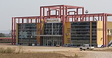
Malanje is a province of Angola. It has an area of 97,602 km² and a 2014 census population of 986,363. Malanje is the provincial capital.

Moçâmedes Municipality in Namibe Province, Angola

Moçâmedes is a city in southwestern Angola, capital of Namibe Province. The city's current population is 255,000. Founded in 1840 by the Portuguese colonial administration, the city was named Namibe between 1985 and 2016. Moçâmedes has a cool dry climate and desert vegetation, because it is near the Namib Desert.

Uíge Province Province of Angola

Uíge is one of the eighteen Provinces of Angola, located in the northwestern part of the country. Its capital city is of the same name.

Angolan War of Independence 1961–1974 conflict for independence of colonial Angola from Portugal

The Angolan War of Independence, called in Angola the Luta Armada de Libertação Nacional, began as an uprising against forced cultivation of cotton, and it became a multi-faction struggle for the control of Portugal's overseas province of Angola among three nationalist movements and a separatist movement. The war ended when a leftist military coup in Lisbon in April 1974 overthrew Portugal's Estado Novo dictatorship, and the new regime immediately stopped all military action in the African colonies, declaring its intention to grant them independence without delay.

Caconda is a town and a municipality in the province of Huíla, Angola. The municipality had a population of 167,820 in 2014.

Ovimbundu

The Ovimbundu, also known as the Southern Mbundu, are a Bantu ethnic group who live on the Bié Plateau of central Angola and in the coastal strip west of these highlands. As the largest ethnic group in Angola, they make up 38 percent of the country's population. Overwhelmingly the Ovimbundu follow Christianity, mainly the Igreja Evangélica Congregacional de Angola (IECA), founded by American missionaries, and the Catholic Church. However, some still retain beliefs and practices from African traditional religions.

Cuíto Municipality in Bié Province, Angola

Cuíto, formerly known as Silva Porto, is a city and municipality in central Angola, capital of Bié Province. The municipality had a population of 450,881 in 2014. Projected to be the tenth fastest growing city on the African continent between 2020 and 2025, with a 5.56% growth.

Ndalatando Commune in Cuanza Norte, Angola

N'dalatando, formerly Vila Salazar, is a town, with a population of 161,584 (2014), and a commune in the municipality of Cazengo, province of Cuanza Norte, Angola.

Ondjiva, formerly Vila Pereira d'Eça, is a town, with a population of 121,537 (2014), and a commune in the municipality of Cuanhama, province of Cunene, Angola. It is also the administrative capital of Cunene Province and is located at the extreme south of the country. The city is located 42 kilometres (26 mi) from the border with Namibia. It was traditionally the seat of the Ovambo king of the Oukwanyama tribe. Ondjiva was greatly affected by the Angolan Civil War (1975-2002).

Rail transport in Angola

Rail transport in Angola consists of three separate Cape gauge lines that do not connect: the northern Luanda Railway, the central Benguela Railway, and the southern Moçâmedes Railway (southern). The lines each connect the Atlantic coast to the interior of the country. A fourth system once linked Gunza and Gabala but is no longer operational.

Luanda Railway

The Luanda Railway is a 424 km (263 mi) single-track Cape gauge railway line from the Angolan capital of Luanda to Malanje. A branch line departs the railway at Zenza do Itombe for Dondo. The line is operated by the state owned company Caminho de Ferro de Luanda E.P., short CFL EP.

Cacuso is a town and municipality in Malanje Province in Angola.

Portuguese Angola 1575–1975 Portuguese possession in West Africa

Portuguese Angola refers to Angola during the historic period when it was a territory under Portuguese rule in southwestern Africa. In the same context, it was known until 1951 as Portuguese West Africa.

Cangandala is a town and municipality in the province of Malanje (Malange) in Angola. It covers an area of 5,770 square kilometres (2,230 sq mi) and its population is 45,120.

History of rail transport in Angola History of rail transport in Angola

The history of rail transport in Angola began during the nineteenth century, when Angola was a colony of Portugal. It has involved the construction, operation and destruction of four separate, unconnected, coast-to-inland systems, in two different gauges. Operations on three of those systems have been largely restored; the other system has been closed.

Cangandala is a commune, with a population of 32,315, and a town, with a population of 16,232, located in Cangandala Municipality in the Malanje Province of Angola.

References

  1. Citypopulation.de Population of provinces and municipalities in Angola
  2. Citypopulation.de Population of the major cities in Angola
  3. "Ranked: The World's Fastest Growing Cities". virtual capitalist. Archived from the original on 13 August 2021. Retrieved 2021-08-17.
  4. "História económico-social de Angola: do período pré-colonial à independência" (PDF). University of Porto (in Portuguese). Retrieved 16 December 2021.
  5. "Geographic coordinates of Malanje, Angola". dateandtime.info. dateandtime.info. 2015. Retrieved 7 September 2015.
  6. "Weatherbase: Historical weather for Malange, Angola" . Retrieved June 18, 2019.

Coordinates: 9°32′S16°21′E / 9.533°S 16.350°E / -9.533; 16.350