
The economy of the Democratic Republic of the Congo has declined drastically around the 1980s, despite being home to vast potential in natural resources and mineral wealth; their gross domestic product is $69.474 billion as of 2023.

Katanga was one of the four large provinces created in the Belgian Congo in 1914. It was one of the eleven provinces of the Democratic Republic of the Congo between 1966 and 2015, when it was split into the Tanganyika, Haut-Lomami, Lualaba, and Haut-Katanga provinces. Between 1971 and 1997, its official name was Shaba Province.
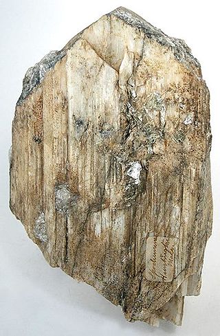
Spodumene is a pyroxene mineral consisting of lithium aluminium inosilicate, LiAl(SiO3)2, and is a commercially important source of lithium. It occurs as colorless to yellowish, purplish, or lilac kunzite (see below), yellowish-green or emerald-green hiddenite, prismatic crystals, often of great size. Single crystals of 14.3 m (47 ft) in size are reported from the Black Hills of South Dakota, United States.

The term Mai-Mai or Mayi-Mayi refers to any kind of community-based militia group active in the Democratic Republic of the Congo (DRC) that is formed to defend local communities and territory against other armed groups. Most were formed to resist the invasion of Rwandan forces and Rwanda-affiliated Congolese rebel groups, but some may have formed to exploit the war to their own advantage by looting, cattle rustling or banditry.

Kolwezi or Kolwesi is the capital city of Lualaba Province in the south of the Democratic Republic of the Congo, west of Likasi. It has an airport and a railway to Lubumbashi. Just outside of Kolwezi there is the static inverter plant of the HVDC Inga-Shaba. The population is approximately 573,000.
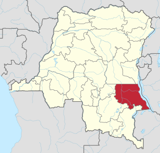
Tanganyika is one of the 21 new provinces of the Democratic Republic of the Congo created in the 2015 repartitioning. Tanganyika, Haut-Katanga, Haut-Lomami and Lualaba provinces are the result of the splitting up of the former Katanga province. Tanganyika was formed from the Tanganyika district whose town of Kalemie was elevated to capital city of the new province.

The mining industry of the Democratic Republic of the Congo produces copper, diamonds, tantalum, tin, gold, and more than 63% of global cobalt production. Minerals and petroleum are central to the DRC's economy, making up more than 95% of the value of its exports.

Pweto Territory is a territory in the Haut-Katanga Province of the Democratic Republic of the Congo (DRC). The headquarters are in the town of Pweto.
The Etoile Mine is an open-pit copper mine on the outskirts of Lubumbashi in Katanga Province of the Democratic Republic of the Congo (DRC). Chemaf owns the license. Chemaf is 95% owned by Shalina Resources and 5% by the DRC government.
The Lukushi River is a tributary of the Luvua River. It runs from south to north through the Malemba-Nkulu Territory of Haut-Lomami Province and the Manono Territory of Tanganyika Province, passing the twin tin-mining towns of Kitotolo and Manono shortly before entering the Luvua.
The Manono-Kitolo mine is a former tin and coltan mine, which also contains one of the largest lithium reserves globally, in the Democratic Republic of the Congo. The mine is located in southern Democratic Republic of the Congo in Tanganyika Province. The Manono-Kitolo mine has reserves amounting to 120 million tonnes of lithium ore grading 0.6% lithium thus resulting 0.72 million tonnes of lithium.
Mai-Mai Kata Katanga, also called Mai-Mai Bakata Katanga, is a mai-mai rebel group in the Democratic Republic of the Congo which advocates the independence of the Congo's Katanga Province. It was formed shortly after the group's leader, Gédéon Kyungu Mutanga, escaped from prison in September 2011 where he was serving a sentence for crimes against humanity committed by his supporters between 2002 and 2006 in central Katanga. Kata Katanga means "cut [e.g. secede] Katanga" in Swahili. It has been estimated that, at its height in 2013, the Kata Katanga rebels numbered approximately 3,000 of whom most were based in Mitwaba Territory.
The Katanga insurgency is an ongoing rebellion by a number of rebel groups in the Democratic Republic of the Congo, some of which aim for the creation of a separate state within Katanga. While the insurgency has been active in various forms since 1963, insurgent groups have recently redoubled their efforts after the 2011 jail break that freed Gédéon Kyungu Mutanga, who commanded the majority of the Katangese separatist groups until his surrender to Congolese authorities in October 2016.
The following is a timeline of the history of the city of Lubumbashi, Democratic Republic of the Congo.

The Special Committee of Katanga was a parastatal body created in 1900 by the Congo Free State and the Compagnie du Katanga. At first it was responsible for administering the huge Katanga Province on behalf of the Free State and for exploiting the province's mineral resources. Mineral exploration and mining were soon delegated to separate companies. After the Belgian Congo took over from the Free State in 1908, the CSK handed over its administrative powers to the provincial government. However, as a parastatal it remained responsible for many aspects of development in Katanga until independence in 1960, when it was dissolved.
Géomines was a Belgian mining company active in the Belgian Congo and then in the Democratic Republic of the Congo. It was established in 1910, and exploited a large deposit in the southeast of the country to become one of the largest tin producers in the world. It was taken over by Zairetain in 1968.
Cominière was a Belgian holding company active in the Belgian Congo. It was involved in plantations, forestry, mining, railways and other activities. The Congo assets were nationalized when the Democratic Republic of the Congo became independent in 1960. What remained of Cominière was acquired by Lonhro in 1971.
The Compagnie Minière des Grands-Lacs (MGL) was a Belgian mining company active in the Belgian Congo and then in the Democratic Republic of the Congo. It was established in 1923 and in 1976 merged with other companies into the Société Minière et Industrielle du Kivu (SOMINKI). The company was active in the eastern regions of Maniema and Kivu, with its main center at Kamituga in today's South Kivu. It extracted gold, tin and other minerals.
Piana–Mwanga Hydroelectric Power Station, also Mpiana–Mwanga Hydroelectric Power Station, is a 54 megawatts (72,000 hp) hydroelectric power station in the Democratic Republic of the Congo. The power plant was originally commissioned in 1933 to service a nearby tin mine. The tin mine was mothballed in 1982 and so was the power station. In 2020, the mining conglomerate AVZ Minerals Limited, reached an agreement to rehabilitate the power station to power its mining operations in Manono Territory, including the Manono–Kitotolo Mine, one of the largest lithium mines in the DRC, whose reserves are estimated at 120,000,000 tonnes of ore.

Kamatanda is a region just north of Likasi in the Haut-Katanga Province of the Democratic Republic of the Congo. It gives its name to an open-pit copper mine, a railway junction, an abandoned airport and a residential area of Likasi.

