Manville, Wyoming

Last updated
Manville, Wyoming
Manville, WY.jpg
Niobrara County Wyoming Incorporated and Unincorporated areas Manville Highlighted 5650270.svg
Location of Manville in Niobrara County, Wyoming
Coordinates: 42°46′46″N104°36′59″W / 42.77944°N 104.61639°W / 42.77944; -104.61639 Coordinates: 42°46′46″N104°36′59″W / 42.77944°N 104.61639°W / 42.77944; -104.61639
Country United States
State Wyoming
County Niobrara
Area
[1]
  Total0.27 sq mi (0.70 km2)
  Land0.27 sq mi (0.70 km2)
  Water0.00 sq mi (0.00 km2)
Elevation
5,253 ft (1,601 m)
Population
 (2010) [2]
  Total95
  Estimate 
(2019) [3]
87
  Density319.85/sq mi (123.60/km2)
Time zone UTC-7 (Mountain (MST))
  Summer (DST) UTC-6 (MDT)
ZIP code
82227
Area code 307
FIPS code 56-50270 [4]
GNIS feature ID1591206 [5]

Manville is a town in Niobrara County, Wyoming, United States. The population was 95 at the 2010 census.

Contents

History

A post office called Manville has been in operation since 1887. [6] The town was named for H. S. Manville, a cattleman. [7]

Geography

Manville is located at 42°46′46″N104°36′59″W / 42.77944°N 104.61639°W / 42.77944; -104.61639 (42.779467, -104.616319). [8]

According to the United States Census Bureau, the town has a total area of 0.27 square miles (0.70 km2), all land. [9]

Demographics

Historical population
CensusPop.
1920 584
1930 201−65.6%
1940 24019.4%
1950 154−35.8%
1960 124−19.5%
1970 92−25.8%
1980 942.2%
1990 973.2%
2000 1014.1%
2010 95−5.9%
2019 (est.)87 [3] −8.4%
U.S. Decennial Census

2010 census

As of the census [2] of 2010, there were 95 people, 48 households, and 30 families residing in the town. The population density was 351.9 inhabitants per square mile (135.9/km2). There were 55 housing units at an average density of 203.7 per square mile (78.6/km2). The racial makeup of the town was 96.8% White, 1.1% Native American, and 2.1% from two or more races. Hispanic or Latino people of any race were 5.3% of the population.

There were 48 households, of which 25.0% had children under the age of 18 living with them, 54.2% were married couples living together, 4.2% had a female householder with no husband present, 4.2% had a male householder with no wife present, and 37.5% were non-families. 33.3% of all households were made up of individuals, and 22.9% had someone living alone who was 65 years of age or older. The average household size was 1.98 and the average family size was 2.50.

The median age in the town was 55.2 years. 17.9% of residents were under the age of 18; 2.2% were between the ages of 18 and 24; 16.8% were from 25 to 44; 24.2% were from 45 to 64; and 38.9% were 65 years of age or older. The gender makeup of the town was 54.7% male and 45.3% female.

2000 census

As of the census [4] of 2000, there were 101 people, 49 households, and 32 families residing in the town. The population density was 357.8 people per square mile (139.3/km2). There were 54 housing units at an average density of 191.3 per square mile (74.5/km2). The racial makeup of the town was 100.00% White.

There were 49 households, out of which 18.4% had children under the age of 18 living with them, 59.2% were married couples living together, 4.1% had a female householder with no husband present, and 32.7% were non-families. 28.6% of all households were made up of individuals, and 16.3% had someone living alone who was 65 years of age or older. The average household size was 2.06 and the average family size was 2.52.

In the town, the population was spread out, with 17.8% under the age of 18, 3.0% from 18 to 24, 16.8% from 25 to 44, 27.7% from 45 to 64, and 34.7% who were 65 years of age or older. The median age was 58 years. For every 100 females, there were 90.6 males. For every 100 females age 18 and over, there were 102.4 males.

The median income for a household in the town was $15,833, and the median income for a family was $28,750. Males had a median income of $41,250 versus $21,250 for females. The per capita income for the town was $11,386. There were 10.5% of families and 13.6% of the population living below the poverty line, including no people under eighteen and 26.7% of those over 64.

Education

Public education in the town of Manville is provided by Niobrara County School District #1. Schools serving the town include Lusk Elementary/Middle School (grades K-6) and Niobrara County High School (grades 7-12).

See also

Related Research Articles

<span class="mw-page-title-main">Weston County, Wyoming</span> County in Wyoming, United States

Weston County is a county in the U.S. state of Wyoming. As of the 2020 United States Census, the population was 6,838. Its county seat is Newcastle. Its east boundary line abuts the west line of the state of South Dakota.

<span class="mw-page-title-main">Platte County, Wyoming</span> County in Wyoming, United States

Platte County is a county located in the U.S. state of Wyoming. As of the 2020 United States Census, the population was 8,605. Its county seat is Wheatland.

<span class="mw-page-title-main">Niobrara County, Wyoming</span> County in Wyoming, United States

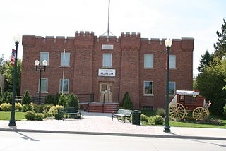
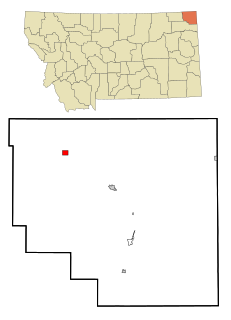
Niobrara County is a county in the U.S. state of Wyoming. As of the 2020 United States Census, the population was 2,467, making it the least populous county in Wyoming. Its county seat is Lusk. Its eastern boundary abuts the west lines of the states of Nebraska and South Dakota.

<span class="mw-page-title-main">Scranton, Kansas</span> City in Osage County, Kansas

Scranton is a city in Osage County, Kansas, United States. As of the 2020 census, the population of the city was 653. It was named after the city of Scranton, Pennsylvania due to its coal mining in the 19th century.

<span class="mw-page-title-main">Merrill, Maine</span> Town in the state of Maine, United States

Merrill is a town in Aroostook County, Maine, United States. The population was 208 at the 2020 census.

<span class="mw-page-title-main">Outlook, Montana</span> Town in Montana, United States

Outlook is a small rural village in Sheridan County, Montana, United States. The population was 84 at the 2020 census. The village includes a post office which services Outlook and the hamlet of Raymond, as well as the surrounding countryside.

<span class="mw-page-title-main">Cumberland Valley Township, Bedford County, Pennsylvania</span> Township in Pennsylvania, United States

Cumberland Valley Township is a township in Bedford County, Pennsylvania, United States. The population was 1,445 at the 2020 census.

<span class="mw-page-title-main">Chest Township, Clearfield County, Pennsylvania</span> Township in Pennsylvania, United States

Chest Township is a township in Clearfield County, Pennsylvania, United States. The population was 511 at the 2020 census.

<span class="mw-page-title-main">Ferguson Township, Clearfield County, Pennsylvania</span> Township in Pennsylvania, United States

Ferguson Township is a township in Clearfield County, Pennsylvania, United States. The population was 545 at the 2020 census.

<span class="mw-page-title-main">Penn Township, Clearfield County, Pennsylvania</span> Township in Pennsylvania, United States

Penn Township is a township in Clearfield County, Pennsylvania, United States. The population was 1,203 at the 2020 census.

<span class="mw-page-title-main">Union Township, Clearfield County, Pennsylvania</span> Township in Pennsylvania, United States

Union Township is a township in Clearfield County, Pennsylvania, United States. The population was 880 at the 2020 census.

<span class="mw-page-title-main">Dunbar Township, Fayette County, Pennsylvania</span> Township in Pennsylvania, United States

Dunbar Township is a township in Fayette County, Pennsylvania, United States. The population was 6,664 at the 2020 census, down from 7,126 at the 2010 census.

<span class="mw-page-title-main">Pike Township, Potter County, Pennsylvania</span> Township in Pennsylvania, United States

Pike Township is a township in Potter County, Pennsylvania, United States. The population was listed at 330 on the 2020 census. The population rose to 324 people as of 2010.

<span class="mw-page-title-main">Hulett, Wyoming</span> Town in Wyoming, United States

Hulett is a town in Crook County, Wyoming, United States. The population was 309 at the 2020 census.

<span class="mw-page-title-main">Moorcroft, Wyoming</span> Town in Wyoming, United States

Moorcroft is a town in Crook County, Wyoming, United States. The population was 946 at the 2020 census.

<span class="mw-page-title-main">Lingle, Wyoming</span> Town in Wyoming, United States

Lingle is a town in Goshen County, Wyoming, United States. The population was 468 at the 2010 census.

<span class="mw-page-title-main">Lance Creek, Wyoming</span> CDP in Wyoming, United States

Lance Creek is a census-designated place (CDP) in Niobrara County, Wyoming, United States. The population was 43 at the 2010 census. Lance Creek is the namesake of the Lance Formation, a rock formation from the Late Cretaceous that has yielded fossils from a diverse number of species.

<span class="mw-page-title-main">Van Tassell, Wyoming</span> Town in Wyoming, United States

Van Tassell is a town in Niobrara County, Wyoming, United States. The population was 15 at the 2010 census. It is the least populous town in the least populous county of the least populous state in the U.S.

<span class="mw-page-title-main">Guernsey, Wyoming</span> Town in Wyoming, United States

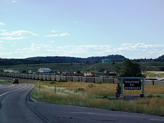
Guernsey is a town in Platte County, Wyoming, United States. The population was 1,147 at the 2010 census.

<span class="mw-page-title-main">Upton, Wyoming</span> Town in Wyoming, United States

Upton is a town in Weston County, Wyoming, United States. The population was 898 at the 2020 census. The slogan of the town is: "The best town on earth".

References

  1. "2019 U.S. Gazetteer Files". United States Census Bureau. Retrieved August 7, 2020.
  2. 1 2 "U.S. Census website". United States Census Bureau . Retrieved 2012-12-14.
  3. 1 2 "Population and Housing Unit Estimates". United States Census Bureau. May 24, 2020. Retrieved May 27, 2020.
  4. 1 2 "U.S. Census website". United States Census Bureau . Retrieved 2008-01-31.
  5. "US Board on Geographic Names". United States Geological Survey. 2007-10-25. Retrieved 2008-01-31.
  6. "Niobrara County". Jim Forte Postal History. Retrieved 22 March 2015.
  7. Chicago and North Western Railway Company (1908). A History of the Origin of the Place Names Connected with the Chicago & North Western and Chicago, St. Paul, Minneapolis & Omaha Railways. p. 97.
  8. "US Gazetteer files: 2010, 2000, and 1990". United States Census Bureau. 2011-02-12. Retrieved 2011-04-23.
  9. "US Gazetteer files 2010". United States Census Bureau. Archived from the original on 2012-01-25. Retrieved 2012-12-14.

Commons-logo.svg Media related to Manville, Wyoming at Wikimedia Commons