Mapungubwe National Park

Last updated

Mapungubwe National Park
Mapungubwe, Limpopo, South Africa (20535429052).jpg
Mapungubwe Hill
Mapungubwe National Park
Location of the park on the Limpopo border
  Mapungubwe National Park
Location Limpopo, South Africa
Nearest city Musina
Coordinates 22°15′S29°12′E / 22.250°S 29.200°E / -22.250; 29.200
Area280 km2 (110 sq mi)
Established
  • 1998 - Vhembe-Dongola National Park
  • 2004 - Mapungubwe National Park
Governing body South African National Parks
World Heritage site2003
www.sanparks.org/parks/mapungubwe/
South Africa relief location map.svg
Red pog.svg
Mapungubwe National Park (South Africa)
South Africa Limpopo relief location map.svg
Red pog.svg
Mapungubwe National Park (Limpopo)

Mapungubwe National Park is a national park in the Limpopo Province, South Africa. The park protects the historical site of Mapungubwe Hill, which was the capital of the Kingdom of Mapungubwe, as well as the wildlife and riverine forests along the Limpopo River. The Mapungubwe Hill was the site of a community dating back to the Iron Age. Evidence has shown that it was a prosperous community. Archaeologists also uncovered the famous Golden Rhinoceros of Mapungubwe figurine from the site.

Contents

It is located at the Kolope River, south of the confluence of the Limpopo and Shashe rivers and about 15 kilometres (9.3 mi) to the NE of the Venetia Diamond Mine. The National Park borders Mapesu Private Game Reserve to the south. It abuts on the border with Botswana and Zimbabwe, and forms part of the UNESCO Mapungubwe Cultural Landscape and the Greater Mapungubwe Transfrontier Conservation Area.

The park was established in 1995 and covers an area of over 28,000 hectares (69,000 acres). It is one of the few places in Africa that has both meerkats and Nile crocodiles.[ citation needed ]

Mapungubwe National Park is renowned for its scenic landscape, with sandstone formations, woodlands, riverine forest and baobab trees.

History

Mapungubwe, Limpopo, South Africa (20356187550).jpg
The Golden Rhinoceros of Mapungubwe found in the park on Mapungubwe Hill.
Mapungubwe gold beads and jewellery - Museum of Gems and Jewellery.jpg
Mapungubwe gold beads and jewellery found in the park.
Mapungubwe Cultural Landscape-114922.jpg
Rock art
Stone game board on Mapungubwe Hill, Limpopo, South Africa.jpg
Stone game board on Mapungubwe Hill.

The history of the Mapungubwe Cultural Landscape dates back 210 million years ago when one of the earliest plant-eating dinosaurs, Plateosauravus (Euskelosaurus), was known to have lived in the area.

The Mapungubwe area became a focus of agricultural research in the 1920s through the efforts of the botanist Illtyd Buller Pole-Evans. Pole-Evans was instrumental in the creation of the Botanical Survey Advisory Committee, which was tasked with coordinating botanical research throughout the Union of South Africa. One of the network of botanical and research stations set up by the Botanical Survey was situated in the Mapungubwe area. At the request of General Smuts, the government set aside a block of nine farms in this area as a preserve for wildlife and natural vegetation in 1918. A few years later this became known as the Dongola Botanical Reserve.

Pole-Evans set about expanding the Dongola Botanical Reserve. [1] By the early 1940s, the reserve had grown to include 27 farms, including Greefswald, the property on which the Mapungubwe Hill is situated. Pole-Evans lobbied to have the reserve proclaimed as a national park, with the support of Prime Minister Jan Smuts. In 1944, Minister of Lands Andrew Conroy proposed the formation of the Dongola Wild Life Sanctuary, which would include 124 farms, 86 of which were privately owned. This proposal was strongly opposed by the National Party, then the official opposition in parliament and the National Parks Board of Trustees. In one of the longest running debates in the history of the South African parliament, supporters argued that it was necessary to conserve the country's natural assets, that the land set aside for the proposed reserve was unsuitable for agricultural purposes and that the area had a rich archaeology which should be protected. Those opposed to the establishment of the reserve argued that it was unacceptable to alienate agricultural land for wildlife conservation, to expropriate private land or to evict people from land they had occupied for generations. The debate, which has become known as the "Battle of Dongola", resulted in the declaration of a much reduced area as the Dongola Wildlife Sanctuary, after members of the ruling United Party voted in favour of the proposal. The National Party won the elections in 1948, and the sanctuary was abolished in 1949. Expropriated farms were returned to their original farmers, farms owned by the state were allocated for resettlement and funds returned to donors.

In 1967, another proposal to protect the area was initiated and the Vhembe Nature Reserve, comprising three farms, including Greefswald, was established as a Transvaal provincial reserve.

In 1993, De Beers Consolidated Mines, which had established the Venetia Limpopo Nature Reserve on land that adjoins Greefswald, called for the area to be declared a national park. In 1995 the South African National Parks Board and the Limpopo provincial government signed an agreement committing themselves to the establishment of the new national park. The Vhembe-Dongola National Park was proclaimed on 9 April 1998.

The Vhembe-Dongola National Park was renamed Mapungubwe National Park and opened officially on Heritage Day, 24 September 2004. In the 21st century, Mapungubwe has been embraced as a site of significance by South Africans and the international community. The Mapungubwe National Park was declared in 1998. [2] The Mapungubwe Cultural Landscape was declared as a National Heritage Site in 2001 and it was inscribed on the World Heritage List in 2003. [3]

The Museum and Interpretive Centre houses artefacts from Mapungubwe. In 2009, the building won the World Architecture Festival's World Building of the Year. Mapungubwe, Limpopo, South Africa (20517691186).jpg
The Museum and Interpretive Centre houses artefacts from Mapungubwe. In 2009, the building won the World Architecture Festival's World Building of the Year.

With the park's UNESCO World Heritage status, a building has been constructed that houses a museum section with many of the artefacts uncovered in the park on display. Information on the park's history and biology is also available at the Museum and Interpretive Centre. [4] In 2009, the building won the World Architecture Festival's World Building of the Year. [5] [6]

Flora and fauna

Vegetation

The numerous habitat types have resulted in high species diversity.

There are at least 24 Acacia species and 8 Commiphora species, amongst others. Other vegetation of the area is a typically short fairly dense growth of shrubby Mopane trees, generally associated with a number of other trees and shrubs and a somewhat sparse and tufted grassveld. The riparian fringe of the Limpopo is of prime importance from the point of view of conservation. It is a dense vegetation community with a closed canopy which occurs in the rich alluvial deposits along the river.

The most striking trees in this community fever trees, ana trees, leadwoods, fig trees and acacias. Extensive patches of this vegetation have been cleared for cultivation elsewhere along the length of the Limpopo River. The Limpopo floodplain has allowed some trees to grow to massive sizes. Nyala berry trees and ana trees can get particularly big.

There are also some very large baobabs in the park, with one specimen having a circumference of 31 metres (102 ft).

Birds

Pel's fishing owl Pels fishing owl.jpg
Pel's fishing owl

387 bird species have been recorded in Mapungubwe National Park and over 400 species occur in the region.

There is a high density of Verreaux's (black) eagle in this craggy landscape and other raptors are also prominent.

Particularly enticing is an abundance of cuckoo species in summer with up to eleven species being found, including the rarer common and thick-billed cuckoos.

An interesting attraction of the park is the occurrence of species typical of the arid western regions of the country (e.g. southern pied babbler, crimson-breasted shrike and black-faced waxbill) occur alongside species associated with the moister Lowveld habitat of the Kruger National Park .

The Limpopo Tree-top Boardwalk and hide is a magnificent facility allowing the visitor into the trees alongside the birds or looking down on those that forage on the ground and lower strata. Meyer's parrots, white-crested helmetshrikes, Meve's starlings and some flycatcher species will be seen. Both tropical and southern boubous occur.

The yellow-bellied greenbul, Meve's (long-tailed) starling, black-backed puffback and tropical boubou can be seen, and southern pied babbler and Natal spurfowl (francolin) are very vocal as are orange-breasted and grey-headed bush-shrikes and grey-backed camaroptera (bleating warbler).

Several species of owl including barn, African and white-faced scops, Verreaux's (giant) eagle, pearl-spotted and Pel's fishing owl occur in Mapungubwe National Park.

Kori bustards are prominent while chestnut-backed sparrow-larks and wattled starlings are nomadic, but may be abundant. Temminck's coursers and ground hornbills may also be seen in this habitat, as will a number of swallows.

The Limpopo Floodplain in flood is a paradise for aquatic birds. Grey crowned cranes, up to seven stork species and several wader, heron, crake and duck species will be seen in these wet times.

There are many stands of Lala palms and collared palm thrushes have been recorded.

Other specials that occur in Mapungubwe National Park include great white pelican, white-backed night heron, bat hawk, augur buzzard, African hobby, Dickinson's kestrel, green sandpiper, three-banded courser, blue-spotted wood dove, grey-headed parrot, Senegal coucal, pennant-winged nightjar, blue-cheeked bee-eater, broad-billed and racket-tailed roller, African golden oriole and olive-tree warbler.

Mammals

African Elephant (Loxodonta africana) bull (33038169621).jpg
African Elephant bull
Klipspringer (Oreotragus oreotragus) male (32332392053).jpg
Male Klipspringer
Nile Monitor (Varanus niloticus) (32762646410).jpg
Nile monitor

Most of the large African game species occur in Mapungubwe National Park. When the Limpopo River is not in flood, they roam freely across it to Botswana and Zimbabwe and back.

Current species include; elephant, hippopotamus, white rhinoceros, lion, leopard, cheetah, Cape wild dog, spotted hyena, brown hyena, eland, blue wildebeest, kudu, Burchell's zebra, bushbuck, waterbuck, impala, klipspringer, duiker, steenbok, red hartebeest, oryx, giraffe, warthog, bush pig, aardvark and baboon.

There are numerous smaller game species, including badgers, civets, porcupine, caracal, vervet monkey, and a host of smaller species.

The wildlife park is also known to be home to at least 17 species of bats. Fruit bats are attracted to the fig trees along the Limpopo River banks, including tree roosting Wahlberg's epauletted fruit bat and the cave dwelling Egyptian fruit bat. [7]

Since 2005, the protected area is considered a Lion Conservation Unit together with South Luangwa National Park. [8]

Reptiles

Rock monitor lizard, water monitor lizard, giant plated lizard, rainbow skink, ground agama and speckled thick toed gecko have all been seen in Mapungubwe National Park. There are estimated to be at least thirty-two species of snake in the park, although only fifteen have thus far been confirmed. Some of these species include the southern African python, snouted cobra, black mamba, both horned and puff adders, and at least three species of whip or sand snakes. [7] Nile crocodile occur in and along the Limpopo River.

Threats

The status of the park as part of the Greater Mapungubwe Transfrontier Conservation Area is severely threatened by the planned exploitation of coal reserves in the immediate vicinity of the reserve. An open-cast coal mine and power plant are planned in the buffer zone of the national park, which threaten its natural and cultural value.[ citation needed ]. In addition, the large amount of water required for the mining activities will impact the ecology of a large part of the region. [9]

See also

Related Research Articles

<span class="mw-page-title-main">Limpopo</span> Northernmost province of South Africa

Limpopo is the northernmost province of South Africa. It is named after the Limpopo River, which forms the province's western and northern borders. The capital and largest city in the province is Polokwane, while the provincial legislature is situated in Lebowakgomo.

<span class="mw-page-title-main">Zimbabwe Parks and Wildlife Management Authority</span>

Zimbabwe Parks and Wildlife Management Authority (Zimparks) is an agency of the Zimbabwe government managing national parks. Zimbabwe's game reserves are managed by the government. They were initially founded as a means of using unproductive land.

<span class="mw-page-title-main">Ezemvelo KZN Wildlife</span> South African wildlife conservation organisation

Ezemvelo KZN Wildlife is a governmental organisation responsible for maintaining wildlife conservation areas and biodiversity in KwaZulu-Natal Province, South Africa. Their headquarters is in Queen Elizabeth Park situated on the northern slopes of Pietermaritzburg, the KwaZulu-Natal provincial capital. Prior to 1994, it was known as the Natal Parks Board.

The Kingdom of Mapungubwe was a medieval state in South Africa located at the confluence of the Shashe and Limpopo rivers, south of Great Zimbabwe. The name is derived from either TjiKalanga and Tshivenda. The name might mean "Hill of Jackals" or "stone monuments". The kingdom was the first stage in a development that would culminate in the creation of the Kingdom of Zimbabwe in the 13th century, and with gold trading links to Rhapta and Kilwa Kisiwani on the African east coast. The Kingdom of Mapungubwe lasted about 140 years, and at its height the capital's population was about 5000 people.

<span class="mw-page-title-main">Tarangire National Park</span> National park in Tanzania, East Africa

Tarangire National Park is a national park in Tanzania's Manyara Region. The name of the park originates from the Tarangire River that crosses the park. The Tarangire River is the primary source of fresh water for wild animals in the Tarangire Ecosystem during the annual dry season. The Tarangire Ecosystem is defined by the long-distance migration of wildebeest and zebras. During the dry season thousands of animals concentrate in Tarangire National Park from the surrounding wet-season dispersal and calving areas.

<span class="mw-page-title-main">Soutpansberg</span> Mountain range in Limpopo, South Africa

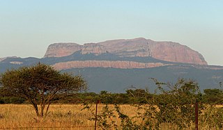
The Soutpansberg, meaning "Salt Pan Mountain" in Afrikaans, is a range of mountains in far northern South Africa. It is located in Vhembe District, Limpopo. It is named for the salt pan located at its western end. The mountain range reaches the opposite extremity in the Matikwa Nature Reserve, some 107 kilometres (66 mi) due east. The range as a whole had no Venda name, as it was instead known by its sub-ranges which include Dzanani, Songozwi and others.

<span class="mw-page-title-main">Mapungubwe Collection</span> Archaeology museum in Gauteng, South Africa

The Mapungubwe Collection, held by the University of Pretoria museums in its Old Arts Building, consists of archaeological materials excavated by the former University of Gauteng from the Mapungubwe archaeological site since its discovery in 1933. The collection includes ceramics, metals, trade glass beads, indigenous beads, clay figurines, and artifacts made from bone and ivory, alongside a research collection of potsherds, faunal remains, and other fragmentary materials. In June 2000, the University of Gauteng inaugurated the permanent museum. The collection is maintained on site, serving both educational and tourism purposes.

<span class="mw-page-title-main">Vhembe District Municipality</span> District municipality in Limpopo, South Africa

The Vhembe District Municipality is one of the 5 districts of the Limpopo province of South Africa. It is the northernmost district of the country and shares its northern border with the Beitbridge District in Zimbabwe and on the east with the Gaza Province in Mozambique. Vhembe consists of all the territories that were part of the former Venda Bantustan; however, two large densely populated districts of the former Tsonga homeland of Gazankulu, in particular, Hlanganani and Malamulele, were also incorporated into the municipality, hence the ethnic diversity of the district. The seat is Thohoyandou, the capital of the former Venda Bantustan. According to the 2011 census, the majority of the municipality's 800,000 inhabitants spoke TshiVenda as their mother language, while 400,000 spoke Xitsonga as their home language. However, the Tsonga people form the majority south of the Levubu River, while the Venda are the minority south of Levubu at 15%. The Sepedi speakers number 27,000. The district code is DC34.

<span class="mw-page-title-main">Wildlife of Zimbabwe</span> Native fauna and flora of Zimbabwe

The wildlife of Zimbabwe occurs foremost in remote or rugged terrain, in national parks and private wildlife ranches, in miombo woodlands and thorny acacia or kopje. The prominent wild fauna includes African buffalo, African bush elephant, black rhinoceros, southern giraffe, African leopard, lion, plains zebra, and several antelope species.

<span class="mw-page-title-main">Thuli Parks and Wildlife Land</span> Protected area in Zimbabwe

Thuli Parks and Wildlife Land is a protected area in south-western Zimbabwe. It comprises four areas within the Zimbabwe Parks and Wildlife Estate and covers the entire west bank of the Shashe River within the Thuli Circle.

<span class="mw-page-title-main">Greater Mapungubwe Transfrontier Conservation Area</span> Transfrontier conservation area in South Africa, Botswana and Zimbabwe

Greater Mapungubwe Transfrontier Conservation Area is a cultural TFCA, formerly known as the Limpopo–Shashe Transfrontier Conservation Area.

<span class="mw-page-title-main">Balule Nature Reserve</span> Protected area in Limpopo Province, South Africa

Balule Nature Reserve is a protected area in Limpopo Province, South Africa which forms part of the Greater Kruger National Park as a member of the Associated Private Nature Reserves (APNR). As part of a wildlife conservation initiative, all fences separating APNR reserves – Balule, Timbavati, Klaserie, Umbabat, – and the Kruger National Park have been removed.

<span class="mw-page-title-main">Blouberg Nature Reserve</span> South African nature reserve

Blouberg Nature Reserve is a protected area situated close to Vivo, west of Louis Trichardt in the Limpopo Province, of South Africa. It covers an area of 9,360 hectares from the eastern portion of the Blouberg mountain range to the savanna near the Brak River, and is founded by Peter Dix and was run under a Concession but it was not renewed and is currently managed and administered by the Limpopo Provincial Government.

<span class="mw-page-title-main">Blouberg (range)</span> Mountain range in Limpopo, South Africa

The Blouberg, meaning "Blue Mountain" in Dutch, is a range of mountains in the Limpopo Province, at the far north of South Africa. It is located in Blouberg Local Municipality, Capricorn District. The mountain is entrenched in the history of the local Northern Sotho people, and they have different names for its various parts.

<span class="mw-page-title-main">Bwabwata National Park</span> Namibian national park

Bwabwata National Park is a protected area in northeastern Namibia that was established in 2007 and covers 6,274 km2 (2,422 sq mi). It was created by merging Namibia's Caprivi Game Park and Mahango Game Park. It is situated in the Zambezi and Kavango East regions, extending along the Caprivi Strip. It is bounded by the Okavango River to the west and the Kwando River to the east. Angola lies to the north and Botswana to the south.

The Peace Park Foundation, founded in 1997 by Dr Anton Rupert, President Nelson Mandela and Prince Bernhard of the Netherlands, is an organisation that aims to re-establish, renew and conserve large ecosystems in Africa, transcending man-made boundaries by creating regionally integrated and sustainably managed networks of Transfrontier Conservation Areas (TFCAs). Peace Parks Foundation has been involved in the establishment and development of ten of the 18 TFCAs found throughout southern Africa, all of which are in various stages of development. The establishment of each TFCA, or peace park, is complex and far-reaching, and involves several phases of activity, which can take many years to achieve.

Mapesu Private Game Reserve is a game reserve in Limpopo Province, South Africa. The reserve adjoins the Mapungubwe National Park and World Heritage Site, with which it shares a 12.5 km Northern border. The main entrance gate to the reserve is located approximately 7 km east of Mapungubwe's entrance gate. It was established in 2014 and covers an area of over 7,200 hectares. The reserve protects various bird, mammal and tree species and is slated to become part of the Greater Mapungubwe Transfrontier Conservation Area in phase 2 as part of the proposed Limpopo Valley Game Reserve.

The following index is provided as an overview of and topical guide to the protected areas of South Africa:

<span class="mw-page-title-main">Philip Herd Nature Reserve</span> Nature reserve in South Africa

Philip Herd Nature Reserve is a nature reserve within the UNESCO Vhembe Biosphere Reserve in the Vhembe District of Limpopo Province, South Africa. The reserve is located east of the town of Musina on the Limpopo River which forms the border between South Africa and Zimbabwe. It covers an area of 12,000 hectares (Ha), of which 6,616.42 Ha is a declared protected area in terms of South Africa's National Environmental Management Act: Protected Areas Act of 2003. The reserve conserves a critically biodiverse area of Limpopo Ridge Bushveld and 1.5% of the Nzhelele River catchment, which forms part of the Limpopo Water Management Area (WMA) established in terms of South Africa's National Water Act of 1998. The reserve operates under the brand name, The Herd Reserve.

References

  1. Carruthers, J. (2011-04-01). "Trouble in the garden: South African botanical politics ca.1870–1950". South African Journal of Botany. 77 (2): 258–267. doi: 10.1016/j.sajb.2011.02.005 .
  2. "NATIONAL PARK - GAZETTED NAME: MAPUNGUBWE NATIONAL PARK" (PDF). Protected Areas Register.
  3. "Mapungubwe Cultural Landscape". UNESCO World Heritage Centre. Retrieved 2023-06-13.
  4. "Mapungubwe National Park - Museum and Interpretive Centre".
  5. "Award winner: World Building of the Year and winner of category culture: "Mapungubwe Interpretation Center, South Africa"". World Buildings Directory. Archived from the original on 2013-10-16.
  6. "Mapungubwe Interpretation Centre by Peter Rich Architects". Dezeen. 2009-11-07. Retrieved 2023-06-13.
  7. 1 2 "The Diverse Wildlife of Mapungubwe National Park". Siyabona Africa. Retrieved 2015-11-05.
  8. IUCN Cat Specialist Group (2006). Conservation Strategy for the Lion Panthera leo in Eastern and Southern Africa. IUCN, Pretoria, South Africa.
  9. Mogakane, Tshwarelo Eseng (20 April 2009). "South Africa: Sanparks Opposes Proposal to Mine Coal at Mapungubwe". BuaNews. Retrieved 2015-11-05 via allAfrica.