Gecko is a browser engine developed by Mozilla. It is used in the Firefox browser, the Thunderbird email client, and many other projects.
GNUstep is a free software implementation of the Cocoa Objective-C frameworks, widget toolkit, and application development tools for Unix-like operating systems and Microsoft Windows. It is part of the GNU Project.
WebKit is a browser engine developed by Apple and primarily used in its Safari web browser, as well as all web browsers on iOS and iPadOS. WebKit is also used by the PlayStation consoles beginning from the PS3, the Tizen mobile operating systems, the Amazon Kindle e-book reader, Nintendo consoles beginning from the 3DS Internet Browser, and the discontinued BlackBerry Browser. WebKit's C++ application programming interface (API) provides a set of classes to display Web content in windows, and implements browser features such as following links when clicked by the user, managing a back-forward list, and managing a history of pages recently visited.
A GIS software program is a computer program to support the use of a geographic information system, providing the ability to create, store, manage, query, analyze, and visualize geographic data, that is, data representing phenomena for which location is important. The GIS software industry encompasses a broad range of commercial and open-source products that provide some or all of these capabilities within various information technology architectures.

OpenStreetMap (OSM) is a free, open geographic database updated and maintained by a community of volunteers via open collaboration. Contributors collect data from surveys, trace from aerial imagery and also import from other freely licensed geodata sources. OpenStreetMap is freely licensed under the Open Database License and as a result commonly used to make electronic maps, inform turn-by-turn navigation, assist in humanitarian aid and data visualisation. OpenStreetMap uses its own topology to store geographical features which can then be exported into other GIS file formats. The OpenStreetMap website itself is an online map, geodata search engine and editor.
The Open Source Geospatial Foundation (OSGeo), is a non-profit non-governmental organization whose mission is to support and promote the collaborative development of open geospatial technologies and data. The foundation was formed in February 2006 to provide financial, organizational and legal support to the broader Free and open-source geospatial community. It also serves as an independent legal entity to which community members can contribute code, funding and other resources.

Web mapping or an online mapping is the process of using maps, usually created through geographic information systems (GIS) on the World Wide Web. A web map or an online map is both served and consumed, thus, web mapping is more than just web cartography, it is a service where consumers may choose what the map will show.
Mapnik is an open-source mapping toolkit for desktop and server based map rendering, written in C++. Artem Pavlenko, the original developer of Mapnik, set out with the explicit goal of creating beautiful maps by employing the sub-pixel anti-aliasing of the Anti-Grain Geometry (AGG) library. Mapnik now also has a Cairo rendering backend. For handling common software tasks such as memory management, file system access, regular expressions, and XML parsing, Mapnik utilizes the Boost C++ libraries. An XML file can be used to define a collection of mapping objects that determine the appearance of a map, or objects can be constructed programmatically in C++, Python, and Node.js.
Chakra is a free and open-source JavaScript engine developed by Microsoft for its Microsoft Edge Legacy web browser. It is a fork of the same-named JScript engine used in Internet Explorer. Like the EdgeHTML browser engine, the declared intention was that it would reflect the "Living Web". The core components of Chakra were open-sourced as ChakraCore.

Simple and Fast Multimedia Library (SFML) is a cross-platform software development library designed to provide a simple application programming interface (API) to various multimedia components in computers. It is written in C++ with bindings available for Ada, C, Crystal, D, Euphoria, Go, Java, Julia, .NET, Nim, OCaml, Python, Ruby, and Rust. Experimental mobile ports were made available for Android and iOS with the release of SFML 2.2.
Servo is an experimental browser engine designed to take advantage of the memory safety properties and concurrency features of the Rust programming language. It seeks to create a highly parallel environment, in which rendering, layout, HTML parsing, image decoding, and other engine components are handled by fine-grained, isolated tasks. It also makes use of GPU acceleration to render web pages quickly and smoothly.
Blink is a browser engine developed as part of the Chromium project with contributions from Apple, Google, Meta, Microsoft, Opera Software, Adobe, Intel, IBM, Samsung, and others. It was first announced in April 2013.
Leaflet is an open source JavaScript library used to build web mapping applications. First released in 2011, it supports most mobile and desktop platforms, supporting HTML5 and CSS3. Among its users are FourSquare, Pinterest and Flickr.
The OpenPOWER Foundation is a collaboration around Power ISA-based products initiated by IBM and announced as the "OpenPOWER Consortium" on August 6, 2013. IBM is opening up technology surrounding their Power Architecture offerings, such as processor specifications, firmware and software with a liberal license, and will be using a collaborative development model with their partners.

A tiled web map,slippy map or tile map is a map displayed in a web browser by seamlessly joining dozens of individually requested image or vector data files. It is the most popular way to display and navigate maps, replacing other methods such as Web Map Service (WMS) which typically display a single large image, with arrow buttons to navigate to nearby areas. Google Maps was one of the first major mapping sites to use this technique. The first tiled web maps used raster tiles, before the emergence of vector tiles.
Vector tiles, tiled vectors or vectiles are packets of geographic data, packaged into pre-defined roughly-square shaped "tiles" for transfer over the web. This is an emerging method for delivering styled web maps, combining certain benefits of pre-rendered raster map tiles with vector map data. As with the widely used raster tiled web maps, map data is requested by a client as a set of "tiles" corresponding to square areas of land of a pre-defined size and location. Unlike raster tiled web maps, however, the server returns vector map data, which has been clipped to the boundaries of each tile, instead of a pre-rendered map image.
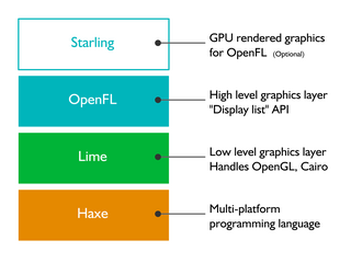
OpenFL is a free and open-source software framework and platform for the creation of multi-platform applications and video games. OpenFL applications can be written in Haxe, JavaScript, or TypeScript, and may be published as standalone applications for several targets including iOS, Android, HTML5, Windows, macOS, Linux, WebAssembly, Flash, AIR, PlayStation 4, PlayStation 3, PlayStation Vita, Xbox One, Wii U, TiVo, Raspberry Pi, and Node.js.
Microsoft, a technology company historically known for its opposition to the open source software paradigm, turned to embrace the approach in the 2010s. From the 1970s through 2000s under CEOs Bill Gates and Steve Ballmer, Microsoft viewed the community creation and sharing of communal code, later to be known as free and open source software, as a threat to its business, and both executives spoke negatively against it. In the 2010s, as the industry turned towards cloud, embedded, and mobile computing—technologies powered by open source advances—CEO Satya Nadella led Microsoft towards open source adoption although Microsoft's traditional Windows business continued to grow throughout this period generating revenues of 26.8 billion in the third quarter of 2018, while Microsoft's Azure cloud revenues nearly doubled.

The Software for Open Networking in the Cloud or alternatively abbreviated and stylized as SONiC, is a free and open source network operating system based on Linux. It was originally developed by Microsoft and the Open Compute Project. In 2022, Microsoft ceded oversight of the project to the Linux Foundation, who will continue to work with the Open Compute Project for continued ecosystem and developer growth. SONiC includes the networking software components necessary for a fully functional L3 device and was designed to meet the requirements of a cloud data center. It allows cloud operators to share the same software stack across hardware from different switch vendors and works on over 100 different platforms. There are multiple companies offering enterprise service and support for SONiC,.