Maribel, Wisconsin

Last updated

Maribel, Wisconsin
MaribelWisconsinDowntown3.jpg
Downtown Maribel
Manitowoc County Wisconsin Incorporated and Unincorporated areas Maribel Highlighted.svg
Location of Maribel in Manitowoc County, Wisconsin.
Coordinates: 44°16′35″N87°48′26″W / 44.27639°N 87.80722°W / 44.27639; -87.80722
Country Flag of the United States.svg  United States
State Flag of Wisconsin.svg  Wisconsin
County Manitowoc
Area
[1]
  Total1.15 sq mi (2.97 km2)
  Land1.14 sq mi (2.96 km2)
  Water0.00 sq mi (0.01 km2)
Elevation
[2]
860 ft (262 m)
Population
 (2020) [3]
  Total336
  Density290.46/sq mi (112.17/km2)
Time zone UTC-6 (Central (CST))
  Summer (DST) UTC-5 (CDT)
Area code 920
FIPS code 55-49250 [4]
GNIS feature ID1569032 [2]

Maribel is a village in Manitowoc County, Wisconsin, United States. The population was 336 at the 2020 census.

Contents

History

A post office called Maribel has been in operation since 1837. [5] The community took its name from a nearby mineral spring. [6]

Geography

Maribel is located at 44°16′35″N87°48′26″W / 44.27639°N 87.80722°W / 44.27639; -87.80722 (44.2763830 -87.8073129). [2]

According to the United States Census Bureau, the village has a total area of 1.17 square miles (3.03 km2), all of it land. [7]

Highways

Demographics

Historical population
CensusPop.Note
1970 316
1980 36314.9%
1990 3722.5%
2000 264−29.0%
2010 35133.0%
2020 336−4.3%
U.S. Decennial Census [8]

2010 census

As of the census [3] of 2010, there were 351 people, 141 households, and 105 families living in the village. The population density was 300.0 inhabitants per square mile (115.8/km2). There were 144 housing units at an average density of 123.1 per square mile (47.5/km2). The racial makeup of the village was 99.1% White, 0.3% Native American, and 0.6% from two or more races. Hispanic or Latino of any race were 0.3% of the population.

There were 141 households, of which 35.5% had children under the age of 18 living with them, 60.3% were married couples living together, 9.2% had a female householder with no husband present, 5.0% had a male householder with no wife present, and 25.5% were non-families. 20.6% of all households were made up of individuals, and 8.5% had someone living alone who was 65 years of age or older. The average household size was 2.49 and the average family size was 2.84.

The median age in the village was 40.6 years. 24.2% of residents were under the age of 18; 7.5% were between the ages of 18 and 24; 25.1% were from 25 to 44; 26.9% were from 45 to 64; and 16.2% were 65 years of age or older. The gender makeup of the village was 48.7% male and 51.3% female.

2000 census

As of the census [4] of 2000, there were 264 people, 99 households, and 72 families living in the village. The population density was 225.3 people per square mile (87.1/km2). There were 100 housing units at an average density of 85.3 per square mile (33.0/km2). The racial makeup of the village was 96.21% White, 0.76% Native American, 0.38% from other races, and 2.65% from two or more races. Hispanic or Latino of any race were 0.38% of the population.

There were 99 households, out of which 40.4% had children under the age of 18 living with them, 62.6% were married couples living together, 9.1% had a female householder with no husband present, and 26.3% were non-families. 23.2% of all households were made up of individuals, and 16.2% had someone living alone who was 65 years of age or older. The average household size was 2.67 and the average family size was 3.04.

In the village, the population was spread out, with 29.9% under the age of 18, 5.3% from 18 to 24, 31.4% from 25 to 44, 20.5% from 45 to 64, and 12.9% who were 65 years of age or older. The median age was 36 years. For every 100 females, there were 91.3 males. For every 100 females age 18 and over, there were 81.4 males.

The median income for a household in the village was $45,938, and the median income for a family was $52,679. Males had a median income of $36,375 versus $23,036 for females. The per capita income for the village was $17,177. About 4.8% of families and 7.0% of the population were below the poverty line, including 8.8% of those under the age of eighteen and 11.8% of those age 65 or over.

Education

Maribel is served by the School District of Denmark, Wisconsin.

St. John's Lutheran School is a Christian Pre-K-8 school of the Wisconsin Evangelical Lutheran Synod in Maribel. [9]

Points of interest

Images

Related Research Articles

<span class="mw-page-title-main">Morrison, Wisconsin</span> Town in Wisconsin, United States

Morrison is a town in Brown County in the U.S. state of Wisconsin. The population was 1,599 at the 2010 census.

<span class="mw-page-title-main">New Denmark, Wisconsin</span> Town in Wisconsin, United States

New Denmark is a town in Brown County in the U.S. state of Wisconsin. The population was 1,562 at the 2020 census. The town surrounds the village of Denmark but is separate from it. The unincorporated communities of Fontenoy and Langes Corners are located in the town. The unincorporated community of Buckman is also located partially in the town.

<span class="mw-page-title-main">Cato, Wisconsin</span> Town in Wisconsin, United States

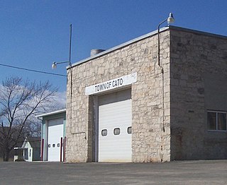
Cato is a town in Manitowoc County, Wisconsin, United States. The population was 1,616 at the 2000 census. A Manitowoc County park is located in the town which is called "Cato Falls" for a waterfall on the Manitowoc River.

<span class="mw-page-title-main">Cleveland (village), Wisconsin</span> Village in Wisconsin, United States

Cleveland is a village in Manitowoc County, Wisconsin, United States. The population was 1,579 at the 2020 census.

<span class="mw-page-title-main">Cooperstown, Wisconsin</span> Town in Wisconsin, United States

Cooperstown is a town in Manitowoc County, Wisconsin, in the United States. As of the 2000 census, the town population was 1,403.

<span class="mw-page-title-main">Francis Creek, Wisconsin</span> Village in Wisconsin, United States

Francis Creek is a village in Manitowoc County, Wisconsin, United States. The population was 659 at the 2020 census. The village is located within the town of Kossuth.

<span class="mw-page-title-main">Kellnersville, Wisconsin</span> Village in Wisconsin, United States

Kellnersville is a village in Manitowoc County, Wisconsin, United States. The population was 307 at the 2020 census.

<span class="mw-page-title-main">Kossuth, Wisconsin</span> Town in Wisconsin, United States

Kossuth is a town in Manitowoc County, Wisconsin, United States. The population was 2,033 at the 2000 census. The village of Francis Creek and the unincorporated community of Rockwood are located in the town. The unincorporated communities of Kingsbridge and Reifs Mills are also located partially in the town.

<span class="mw-page-title-main">Manitowoc Rapids, Wisconsin</span> Town in Wisconsin, United States

Manitowoc Rapids is a town in Manitowoc County, Wisconsin, United States. The population was 2,520 at the 2000 census.

<span class="mw-page-title-main">Maple Grove, Manitowoc County, Wisconsin</span> Town in Wisconsin, United States

Maple Grove is a town in Manitowoc County, Wisconsin, United States. The population was 852 at the 2000 census.

<span class="mw-page-title-main">Meeme, Wisconsin</span> Town in Wisconsin, United States

Meeme is a town in Manitowoc County, Wisconsin, United States. The population was 1,538 at the 2000 census. Its Menominee name is Omīnīw which means "pigeon". The Menominee sold this land to the United States in the 1831 Treaty of Washington.

<span class="mw-page-title-main">Reedsville, Wisconsin</span> Village in Wisconsin, United States

Reedsville is a village in Manitowoc County, Wisconsin, United States. The population was 1,195 at the 2020 census.

<span class="mw-page-title-main">St. Nazianz, Wisconsin</span> Village in Wisconsin, United States

St. Nazianz is a village in Manitowoc County, Wisconsin, United States. Founded in 1854, the population was 783 at the 2010 census.

<span class="mw-page-title-main">Valders, Wisconsin</span> Village in Wisconsin, United States

Valders is a village in Manitowoc County, Wisconsin, United States. The population was 962 at the 2010 census.

<span class="mw-page-title-main">Whitelaw, Wisconsin</span> Village in Wisconsin, United States

Whitelaw is a village in Manitowoc County, Wisconsin, United States. The population was 737 at the 2020 census.

<span class="mw-page-title-main">Brillion (town), Wisconsin</span>

Brillion is a town in Calumet County in the U.S. state of Wisconsin. The population was 1,486 at the 2010 census.

Jefferson is a town in Jefferson County, Wisconsin, United States. The population was 2,178 at the 2010 census. The city of Jefferson is located partially within the town. The census-designated place of Helenville is also located in the town.

Manitowoc is a town in Manitowoc County, Wisconsin, United States. The population was 1,073 at the 2000 census. The city of Manitowoc divides the town into two noncontiguous sections, one north of the city and one south.

<span class="mw-page-title-main">Mishicot (town), Wisconsin</span> Town in Wisconsin, United States

Mishicot is a town in Manitowoc County, Wisconsin, United States. The population was 1,409 at the 2000 census. The Village of Mishicot is located within the town. The unincorporated communities of Fisherville, Kingsbridge, and Tisch Mills are also located partially in the town.

<span class="mw-page-title-main">Mishicot, Wisconsin</span> Village in Wisconsin, United States

Mishicot is a village in Manitowoc County, Wisconsin, United States. The population was 1,442 at the 2010 census. The village is adjacent to the Town of Mishicot.

References

  1. "2019 U.S. Gazetteer Files". United States Census Bureau. Retrieved August 7, 2020.
  2. 1 2 3 "US Board on Geographic Names". United States Geological Survey. August 29, 1980. Retrieved March 9, 2016.
  3. 1 2 "U.S. Census website". United States Census Bureau . Retrieved November 18, 2012.
  4. 1 2 "U.S. Census website". United States Census Bureau . Retrieved January 31, 2008.
  5. "Manitowoc County". Jim Forte Postal History. Retrieved March 22, 2015.
  6. Chicago and North Western Railway Company (1908). A History of the Origin of the Place Names Connected with the Chicago & North Western and Chicago, St. Paul, Minneapolis & Omaha Railways. p. 98.
  7. "US Gazetteer files 2010". United States Census Bureau. Archived from the original on January 25, 2012. Retrieved November 18, 2012.
  8. "Census of Population and Housing". Census.gov. Retrieved June 4, 2015.
  9. "St. John's Lutheran School" . Retrieved January 20, 2020.