
Kavad I was the Sasanian King of Kings of Iran from 488 to 531, with a two or three-year interruption. A son of Peroz I, he was crowned by the nobles to replace his deposed and unpopular uncle Balash.

Peroz I was the Sasanian King of Kings of Iran from 459 to 484. A son of Yazdegerd II, he disputed the rule of his elder brother and incumbent king Hormizd III, eventually seizing the throne after a two-year struggle. His reign was marked by war and famine. Early in his reign, he successfully quelled a rebellion in Caucasian Albania in the west, and put an end to the Kidarites in the east, briefly expanding Sasanian rule into Tokharistan, where he issued gold coins with his likeness at Balkh. Simultaneously, Iran was suffering from a seven-year famine. He soon clashed with the former subjects of the Kidarites, the Hephthalites, who possibly had previously helped him to gain his throne. He was defeated and captured twice by the Hephthalites and lost his recently acquired possessions.

Yazdegerd II, was the Sasanian King of Kings of Iran from 438 to 457. He was the successor and son of Bahram V.

Caucasian Albania is a modern exonym for a former state located in ancient times in the Caucasus, mostly in what is now Azerbaijan. The modern endonyms for the area are Aghwank and Aluank, among the Udi people, who regard themselves as descended from the inhabitants of Caucasian Albania. However, its original endonym is unknown.

Derbent, formerly romanized as Derbend, is a city in Dagestan, Russia, located on the Caspian Sea. It is the southernmost city in Russia, and it is the second-most important city of Dagestan. Derbent occupies the narrow gateway between the Caspian Sea and the Caucasus Mountains connecting the Eurasian Steppe to the north and the Iranian Plateau to the south; covering an area of 69.63 square kilometres (26.88 sq mi), with a population of roughly 120,000 residents.

Juansher was the Mihranid prince of Caucasian Albania, ruling the principality from 637 to 669. He was the son and successor of Varaz Grigor.
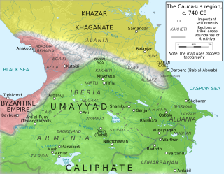
The Arab–Khazar wars were a series of conflicts fought between the Khazar Khaganate and successive Arab caliphates in the Caucasus region from c. 642 to 799 CE. Smaller native principalities were also involved in the conflict as vassals of the two empires. Historians usually distinguish two major periods of conflict, the First Arab–Khazar War and Second Arab–Khazar War ; the wars also involved sporadic raids and isolated clashes from the mid-seventh century to the end of the eighth century.

Barda is a city and the capital of the Barda District in Azerbaijan, located south of Yevlax and on the left bank of the Tartar river. It served as the capital of Caucasian Albania by the end of the 5th-century. Barda became the chief city of the Islamic province of Arran, the classical Caucasian Albania, remaining so until the tenth century.

Caucasian Albania was a kingdom in the Caucasus, which was under the suzerainty of the Sasanian Empire from 252 to 636.
Sanesan or Sanatruk was the king of Maskut in the early 4th century. Sanesan's people, the Mazk'kut'k, have variously been identified as the Massagetae or as the Meskheti.
The Arsacid dynasty was a dynasty of Parthian origin, which ruled the kingdom of Caucasian Albania from the 3rd to the 6th century. They were a branch of the Arsacid dynasty of Parthia and together with the Arsacid rulers of the neighboring Armenia and Iberia formed a pan-Arsacid family federation.
Urnayr was the third Arsacid king of Caucasian Albania from approximately 350 to 375. He was the successor of Vache I.
Aswagen was the eight Arsacid king of Caucasian Albania, ruling from approximately 415 to 440. He was most likely the son of the previous Albanian king Urnayr, while his mother was a daughter of the Sasanian King of Kings (shahanshah) of Iran, Shapur II. Aswagen was himself married to a daughter of shahanshah Yazdegerd II. It was under Aswagen that the Caucasian Albanian script was created in c. 420.
Vache II was the ninth Arsacid king of Caucasian Albania from approximately 440 to 462. He was the son and successor of Aswagen. His mother was a daughter of the Sasanian king Yazdegerd II, and he was himself married to the niece or sister of Peroz I.

Vachagan IIIthe Pious or Vachagan II was the last Arsacid king of Caucasian Albania, ruling approximately from 485 to 523.

The defense lines of the Sasanians were part of their military strategy and tactics. They were networks of fortifications, walls, and/or ditches built opposite the territory of the enemies. These defense lines are known from tradition and archaeological evidence.

The Fortifications of Derbent (Darband) are one of the fortified defense lines, some of which date to the times as early as those built by the Persian Sasanian Empire to protect the eastern passage of the Caucasus Mountains against the attacks of the nomadic peoples of the Pontic–Caspian steppe. With the first parts built in the 6th century during the reign of Persian emperor Khosrow I and maintained by various later Arab, Turkish and Persian regimes, the fortifications comprise three distinct elements: the citadel of Naryn-Kala at Derbent, the twin long walls connecting it with the Caspian Sea in the east, and the "mountain wall" of Dagh-Bary, running from Derbent to the Caucasus foothills in the west. The immense wall, with a height of up to twenty meters and a thickness of about 10 feet, stretched for forty kilometers between the Caspian Sea and the Caucasus Mountains, thirty north-looking towers stretched for forty kilometers between the Caspian Sea and the Caucasus Mountains, effectively blocking the passage across the Caucasus. The fortification complex was made a UNESCO World Heritage Site in 2003.

Murtazali Gadjiev is a Russian-Dagestani archaeologist and scholar. He is the head of the archaeology department of Dagestan Scientific Center of Russian Academy of Science.
Chola was ancient province, as well as its capital city located western coast of Caspian Sea in Toprakhgala archaeological site of Derbent.
The Lupenians or Lpins were a historical tribe that lived in modern-day Republic of Azerbaijan in antiquity. The Lupenians were mentioned in several sources in different languages. They are equated with Pliny's Lupenii, dwelling south of the tribe of Silvii (Chola), just next to the Diduri and near the frontier of Caucasian Albania. Agathangelos renders their name in Greek as Lifénnioi. The Ravenna Cosmography mentions their land as "Patria Lepon" situated next to Iberia and the Caspian Sea. The Tabula Peutingeriana also mentions the Lupenii. Vladimir Minorsky proposed later Arabic versions as well. They were probably related to the Caucasian Albanians.
