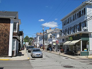
Mystic is a village and census-designated place (CDP) in Groton and Stonington, Connecticut.

North Stonington is a town in New London County, Connecticut which was split off from Stonington in 1724. The town is part of the Southeastern Connecticut Planning Region. The population was 5,149 at the 2020 census.

Stonington is a town in Hancock County, Maine, United States. It is located on the southern portion of the island of Deer Isle. The population was 1,056 at the 2020 census. It includes the villages of Burnt Cove, Oceanville, Green Head, and Clam City. A picturesque working waterfront and tranquil tourist destination in eastern Penobscot Bay, Stonington has consistently ranked among the top lobster ports in the country and is the largest lobster port in Maine. In 2011, 14,854,989 pounds of lobster were landed by Stonington fishermen, with a value of $46.3 million.

Fishers Island is an island that is part of Southold, New York, United States at the eastern end of Long Island Sound, 2 miles (3 km) off the southeastern coast of Connecticut across Fishers Island Sound. About 9 miles (14 km) long and 1 mile (1.6 km) wide, it is about 11 miles (18 km) from the tip of Long Island at Orient Point, 2 miles (3 km) each from Napatree Point at the southwestern tip of Rhode Island and Groton Long Point in Connecticut, and about 7 miles (11 km) southeast of New London, Connecticut. It is accessible from New London by plane and regular ferry service.

Stonington is a town located in New London County, Connecticut. The municipal limits of the town include the borough of Stonington, the villages of Pawcatuck, Lords Point, and Wequetequock, and the eastern halves of the villages of Mystic and Old Mystic. Stonington is part of the Southeastern Connecticut Planning Region. The population of the town was 18,335 at the 2020 census.

John Mason was an English-born settler, soldier, commander and Deputy Governor of the Connecticut Colony. Mason was best known for leading a group of Puritan settlers and Indian allies on a combined attack on a Pequot Fort in an event known as the Mystic Massacre. The destruction and loss of life he oversaw effectively ended the hegemony of the Pequot tribe in southeast Connecticut.

The Mystic River is a 3.4-mile-long (5.5 km) estuary in the southeast corner of the U.S. state of Connecticut. Its main tributary is Whitford Brook. It empties into Fishers Island Sound, dividing the village of Mystic, Connecticut between the towns of Groton and Stonington. Much of the river is tidal. The Mystic River was the location of three large shipbuilding firms during the 19th-century, and it is now the home of the Mystic Seaport maritime museum. The name Mystic is derived from the Pequot term "missi-tuk", describing a large river whose waters are driven into waves by tides or wind, according to the Mystic River Historical Society.

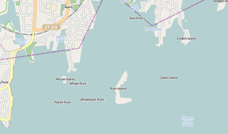
Ram Island is a small 20-acre (81,000 m2) island off the coast of Mystic, Connecticut. It is located in the Town of Stonington, approximately 1 mile (1.6 km) offshore, between Mystic and Fishers Island. Once called Mystic Island, it was formerly the site of an exclusive Victorian era hotel resort at which steamships from Boston and New York City stopped twice a day. At the height of its popularity, the hotel played host to a world lightweight bare-knuckle boxing championship. By the 1920s, the hotel had fallen into disrepair and was destroyed in the New England Hurricane of 1938. A motel was later built that catered to transient boaters.

The Mystic massacre – also known as the Pequot massacre and the Battle of Mystic Fort – took place on May 26, 1637 during the Pequot War, when a force from Connecticut Colony under Captain John Mason and their Narragansett and Mohegan allies set fire to the Pequot Fort near the Mystic River. They shot anyone who tried to escape the wooden palisade fortress and killed most of the village. There were between 400 and 700 Pequots killed during the attack; the only Pequot survivors were warriors who were away in a raiding party with their sachem Sassacus.

Crandon Park is an 808-acre (3.27 km2) urban park in metropolitan Miami, occupying the northern part of Key Biscayne. It is connected to mainland Miami via the Rickenbacker Causeway.

Lantern Hill, elevation 491 feet, is a hill located in North Stonington, New London County, Connecticut.

Enders Island is an 11-acre island located within the town of Stonington, just off the coast of the Mystic section of the town, in the U.S. state of Connecticut. The island located in the Fisher's Island Sound at the base of the Mystic River and is connected to neighboring Mason's Island by a causeway. Mason's Island is connected to the mainland by another causeway. Its sole inhabitants operate a retreat center and art school owned by the Catholic Society of Saint Edmund. Enders Island is also home to the bi-annual residency portion of Fairfield University's Master of Fine Arts in Creative Writing Program. The Island is available to the public, with a chapel, surrounding views of the Atlantic, walking paths with flower gardens and a gift store.
The Mystic River Historic District encompasses the part of the village of Mystic, Connecticut that is on the Groton side of the Mystic River. The district was added to the National Register of Historic Places on August 24, 1979, approximately 235-acre (95 ha) which includes much of the village of West Mystic and many buildings from the 19th century.
Sandy Point Island is a 35-acre (14 ha) island in Little Narragansett Bay, lying mostly in Westerly, Rhode Island and partly in Stonington, Connecticut. Once an extension of Napatree Point, Sandy Point is now a one-mile-long (1.6 km) island that serves as an important nature preserve and recreation site. Sandy Point is the westernmost piece of land in the state of Rhode Island.

The Narragansett Trail is a 16-mile (26 km) hiking trail in Connecticut and is one of the Blue-Blazed Trails, maintained by the Connecticut Forest and Park Association and the Narragansett Council, and The Rhode Island chapter of Scouts BSA.
Elihu Island is a private island off the coast of Stonington, Connecticut. It is located in Wequetequock Cove, just southwest of Goat Island and northeast of the western tip of Sandy Point Island. It has been variously known as Ledward or Ledward's Island, Elihu's or Elihue's Island, Elihu Chesebrough's Island, and Freeman's Island.

Bluff Point State Park is a public recreation area and nature preserve on an undeveloped peninsula located between the Poquonnock River and Mumford Cove on Long Island Sound in the town of Groton, Connecticut. The state park's 806 acres (326 ha) encompass a barrier beach, steep cliffs, forested sections, and tidal wetlands; 778 acres (315 ha) are designated as a coastal reserve. Recreational opportunities include hiking, mountain biking, boating, saltwater fishing, and shell fishing. The park is managed by the Connecticut Department of Energy and Environmental Protection.
John Gallup was an early settler and militia captain in Southeastern Connecticut.
Poggatacut also known as Youghco or Poggatticut, was sachem of the Manhasset Indian people of Shelter Island, New York and elder brother to Montaukett Sachem Wyandanch. Sachem Poggatacut and his wife Aswaw granted possession to Lion Gardiner for Gardiners Island in 1639. It was conveyed when they deeded Manchonat, an Island between the north and south fork in exchange for goods and alliance. By 1644 he had united the Corchaug, Shinnecock, Manhassets and Montaukett before retreating as Grand Sachem to his redoubt on Shelter Island, relinquishing control over the tribes to his younger brother, sachem Wyandanch. As “Sachem of Paumanacke", as Long Island was called, he was empowered to make treaties for the Montauketts.


