List of islands of Connecticut

Last updated

This is a list of islands of Connecticut . The list does not include named minor rock outcroppings, former islands that are now connected to the mainland by landfill, or false islands that are connected by thin slivers of land to the mainland. Unless otherwise indicated, listed islands are in Long Island Sound.

Name Town CoordinatesNotes
Andrews Island Branford 41°15′48″N72°45′57″W / 41.26333°N 72.76583°W / 41.26333; -72.76583
Andrews Island Stonington 41°20′00″N71°57′21″W / 41.33333°N 71.95583°W / 41.33333; -71.95583
Ball Island New Haven 41°18′27″N72°54′25″W / 41.30750°N 72.90694°W / 41.30750; -72.90694 Mill River
Barn Island Stonington 41°19′46″N71°52′06″W / 41.32944°N 71.86833°W / 41.32944; -71.86833
Barton Island Griswold 41°33′29″N71°53′53″W / 41.55806°N 71.89806°W / 41.55806; -71.89806 Pachaug Pond
Bear Island Branford 41°15′29″N72°44′21″W / 41.25806°N 72.73917°W / 41.25806; -72.73917 Part of Thimble Islands
Beers Island Branford 41°15′25″N72°44′38″W / 41.25694°N 72.74389°W / 41.25694; -72.74389 Part of Thimble Islands
Belden Island Branford 41°15′47″N72°45′42″W / 41.26306°N 72.76167°W / 41.26306; -72.76167
Betts Island Norwalk 41°04′13″N73°23′29″W / 41.07028°N 73.39139°W / 41.07028; -73.39139 Part of Norwalk Islands
Bluff Island Greenwich 41°00′38″N73°35′55″W / 41.01056°N 73.59861°W / 41.01056; -73.59861
Bowers Island Greenwich 40°59′45″N73°38′04″W / 40.99583°N 73.63444°W / 40.99583; -73.63444
Brockway Island Essex 41°22′24″N72°22′35″W / 41.37333°N 72.37639°W / 41.37333; -72.37639 Connecticut River
Burr Island Branford 41°15′48″N72°45′17″W / 41.26333°N 72.75472°W / 41.26333; -72.75472
Calf Islands Greenwich 40°59′30″N73°38′23″W / 40.99167°N 73.63972°W / 40.99167; -73.63972
Calf Pasture Island Norwalk 41°04′57″N73°23′01″W / 41.08250°N 73.38361°W / 41.08250; -73.38361 Part of Norwalk Islands
Calves Island Old Lyme 41°19′35″N72°20′41″W / 41.32639°N 72.34472°W / 41.32639; -72.34472 Connecticut River
Candlewood Isle New Fairfield 41°28′52″N73°27′15″W / 41.48111°N 73.45417°W / 41.48111; -73.45417 Candlewood Lake
Canfield Island Norwalk/Westport 41°05′49″N73°22′58″W / 41.09694°N 73.38278°W / 41.09694; -73.38278
Carting Island Stratford 41°12′48″N73°06′47″W / 41.21333°N 73.11306°W / 41.21333; -73.11306 Housatonic River
Cat Island Branford 41°15′15″N72°44′20″W / 41.25417°N 72.73889°W / 41.25417; -72.73889 Part of Thimble Islands
Cedar Hammock Norwalk 41°04′10″N73°25′04″W / 41.06944°N 73.41778°W / 41.06944; -73.41778
Cedar Island Branford 41°15′30″N72°45′39″W / 41.25833°N 72.76083°W / 41.25833; -72.76083
Cedar Island Brookfield 41°31′43″N73°26′31″W / 41.52861°N 73.44194°W / 41.52861; -73.44194 New Milford Bay
Cedar Island Clinton 41°15′56″N72°31′33″W / 41.26556°N 72.52583°W / 41.26556; -72.52583 Connected to mainland by landfill
Charles Island Milford 41°11′27″N73°03′17″W / 41.19083°N 73.05472°W / 41.19083; -73.05472 Connected by sandbar to mainland during low tide.
Chauncey Island Ridgefield 41°19′22″N73°30′21″W / 41.32278°N 73.50583°W / 41.32278; -73.50583 Lake Naraneka
Chimon Island Norwalk 41°03′57″N73°23′30″W / 41.06583°N 73.39167°W / 41.06583; -73.39167 Part of Norwalk Islands
Clam Island Branford 41°14′51″N72°48′54″W / 41.24750°N 72.81500°W / 41.24750; -72.81500
Clown Island Torrington 41°46′07″N73°06′44″W / 41.76861°N 73.11222°W / 41.76861; -73.11222
Cockenoe Island Westport 41°05′01″N73°21′18″W / 41.08361°N 73.35500°W / 41.08361; -73.35500 Part of Norwalk Islands
Copps Island Norwalk 41°03′31″N73°23′13″W / 41.05861°N 73.38694°W / 41.05861; -73.38694 Part of Norwalk Islands
Connected by sandbar to Crow Island
Cove Island Stamford 41°02′50″N73°30′03″W / 41.04722°N 73.50083°W / 41.04722; -73.50083
Crab Island Darien 41°03′01″N73°27′41″W / 41.05028°N 73.46139°W / 41.05028; -73.46139
Crow Island Norwalk 41°03′40″N73°23′26″W / 41.06111°N 73.39056°W / 41.06111; -73.39056 Part of Norwalk Islands
Connected by sandbar to Chimon Island and Copps Island
Curatole Island New Hartford 41°52′46″N73°02′37″W / 41.87944°N 73.04361°W / 41.87944; -73.04361 West Hill Pond
Cut in Two Island Branford 41°15′30″N72°44′45″W / 41.25833°N 72.74583°W / 41.25833; -72.74583 Part of Thimble Islands
Cuties Island (Vincent Island) Stamford 41°02′08″N73°30′36″W / 41.03556°N 73.51000°W / 41.03556; -73.51000 Also a ghost town.
Davis Island Branford 41°15′20″N72°44′44″W / 41.25556°N 72.74556°W / 41.25556; -72.74556 Part of Thimble Islands
Deer Island Sherman 41°32′14″N73°27′50″W / 41.53722°N 73.46389°W / 41.53722; -73.46389 Candlewood Lake
Deer Island Litchfield 41°41′48″N73°13′42″W / 41.69667°N 73.22833°W / 41.69667; -73.22833 Bantam Lake
Diving Island Greenwich 41°00′48″N73°35′58″W / 41.01333°N 73.59944°W / 41.01333; -73.59944
Dodges Island Stonington 41°19′44″N71°57′15″W / 41.32889°N 71.95417°W / 41.32889; -71.95417
Dog Island Norwalk 41°03′30″N73°24′35″W / 41.05833°N 73.40972°W / 41.05833; -73.40972 Part of Norwalk Islands
Dogfish Island Branford 41°15′25″N72°44′49″W / 41.25694°N 72.74694°W / 41.25694; -72.74694 Part of Thimble Islands
Duck Island Westbrook 41°15′22″N72°28′30″W / 41.25611°N 72.47500°W / 41.25611; -72.47500
Duck Island Milford 41°10′27″N73°06′30″W / 41.17417°N 73.10833°W / 41.17417; -73.10833 Charles E. Wheeler Wildlife Management Area
Dunks Island Old Saybrook 41°16′48″N72°22′54″W / 41.28000°N 72.38167°W / 41.28000; -72.38167 Wetlands off Plum Back River
East Crib Branford 41°15′11″N72°45′12″W / 41.25306°N 72.75333°W / 41.25306; -72.75333 Part of Thimble Islands
East Stooping Bush Island Branford 41°15′04″N72°44′50″W / 41.25111°N 72.74722°W / 41.25111; -72.74722 Part of Thimble Islands
Elihu Island Stonington 41°20′12″N71°53′14″W / 41.33667°N 71.88722°W / 41.33667; -71.88722
Enders Island Stonington 41°19′20″N71°57′46″W / 41.32222°N 71.96278°W / 41.32222; -71.96278
Eustasia Island Lyme 41°23′32″N72°25′13″W / 41.39222°N 72.42028°W / 41.39222; -72.42028 Connecticut River
Falkner Island Guilford 41°12′41″N72°39′18″W / 41.21139°N 72.65500°W / 41.21139; -72.65500
Fayerweather Island Bridgeport 41°8′35″N73°12′58″W / 41.14306°N 73.21611°W / 41.14306; -73.21611 Long Island Sound near Black Rock Harbor.
Fish Islands Darien 41°02′54″N73°27′26″W / 41.04833°N 73.45722°W / 41.04833; -73.45722
Foskett Island Guilford 41°15′29″N72°42′40″W / 41.25806°N 72.71111°W / 41.25806; -72.71111
Fowler Island Milford 41°14′13″N73°06′08″W / 41.23694°N 73.10222°W / 41.23694; -73.10222 Housatonic River
Fox Island Lebanon 41°38′23″N72°18′27″W / 41.63972°N 72.30750°W / 41.63972; -72.30750 Williams Pond
Frisbie Island Branford 41°15′46″N72°45′18″W / 41.26278°N 72.75500°W / 41.26278; -72.75500
Gates Island Groton 41°18′55″N71°58′01″W / 41.31528°N 71.96694°W / 41.31528; -71.96694
Gildersleeve Island Portland 41°36′21″N72°36′52″W / 41.60583°N 72.61444°W / 41.60583; -72.61444 Connecticut River
Goat Island Stonington 41°20′27″N71°53′07″W / 41.34083°N 71.88528°W / 41.34083; -71.88528
Goodyear Island New Milford/Bridgewater 41°32′16″N73°24′15″W / 41.53778°N 73.40417°W / 41.53778; -73.40417 Lake Lillinonah (Housatonic River)
Goose Island Greenwich 41°01′00″N73°35′57″W / 41.01667°N 73.59917°W / 41.01667; -73.59917
Goose Island Stratford 41°11′39″N73°07′01″W / 41.19417°N 73.11694°W / 41.19417; -73.11694 Housatonic River
Goose Island Old Lyme 41°20′10″N72°20′56″W / 41.33611°N 72.34889°W / 41.33611; -72.34889 Connecticut River
Goose Island Westport 41°04′18″N73°22′17″W / 41.07167°N 73.37139°W / 41.07167; -73.37139 Part of Norwalk Islands
Gorham Island Westport 41°08′38″N73°21′47″W / 41.14389°N 73.36306°W / 41.14389; -73.36306 Saugatuck River
Governor Island Branford 41°15′17″N72°45′21″W / 41.25472°N 72.75583°W / 41.25472; -72.75583 Part of Thimble Islands
Governors Island Hampton 41°47′30″N72°05′03″W / 41.79167°N 72.08417°W / 41.79167; -72.08417 Pine Acres Lake
Grannis Island New Haven Quinnipiac River
Grass Island Stamford 41°01′35″N73°32′22″W / 41.02639°N 73.53944°W / 41.02639; -73.53944
Grassy Island Norwalk/Westport 41°04′13″N73°23′00″W / 41.07028°N 73.38333°W / 41.07028; -73.38333 Part of Norwalk Islands
Great Captain Island Greenwich 40°58′56″N73°37′43″W / 40.98222°N 73.62861°W / 40.98222; -73.62861
Great Island Old Lyme 41°17′17″N72°19′56″W / 41.28806°N 72.33222°W / 41.28806; -72.33222
Green Island Branford 41°15′19″N72°50′35″W / 41.25528°N 72.84306°W / 41.25528; -72.84306
Green Island Sherman 41°32′53″N73°28′07″W / 41.54806°N 73.46861°W / 41.54806; -73.46861 Candlewood Lake
Greenaway Island (Caritas Island) Stamford 41°02′12″N73°30′20″W / 41.03667°N 73.50556°W / 41.03667; -73.50556
Greenwich Island Greenwich 41°00′44″N73°34′37″W / 41.01222°N 73.57694°W / 41.01222; -73.57694
Griswold Island East Lyme 41°17′40″N72°13′27″W / 41.29444°N 72.22417°W / 41.29444; -72.22417
Haddam Island Haddam 41°29′30″N72°31′05″W / 41.49167°N 72.51806°W / 41.49167; -72.51806 Connecticut River
Hall Island Stonington 41°19′39″N71°51′04″W / 41.32750°N 71.85111°W / 41.32750; -71.85111 Pawcatuck River
Hen Island Branford 41°15′14″N72°44′48″W / 41.25389°N 72.74667°W / 41.25389; -72.74667 Part of Thimble Islands
High Island Branford 41°14′57″N72°45′28″W / 41.24917°N 72.75778°W / 41.24917; -72.75778 Part of Thimble Islands
Hobs Island Groton 41°19′19″N72°04′33″W / 41.32194°N 72.07583°W / 41.32194; -72.07583 Thames River
Holly Hock Island Norwich 41°31′39″N72°05′11″W / 41.52750°N 72.08639°W / 41.52750; -72.08639 Yantic River
Horse Island Greenwich 41°00′50″N73°36′17″W / 41.01389°N 73.60472°W / 41.01389; -73.60472
Horse Island Branford 41°14′40″N72°45′27″W / 41.24444°N 72.75750°W / 41.24444; -72.75750 Part of Thimble Islands
Horse Island Guilford 41°15′28″N72°42′23″W / 41.25778°N 72.70639°W / 41.25778; -72.70639
Hoyt Island Norwalk 41°04′26″N73°25′09″W / 41.07389°N 73.41917°W / 41.07389; -73.41917
Huntley Island East Lyme 41°17′50″N72°13′26″W / 41.29722°N 72.22389°W / 41.29722; -72.22389
Inner White Top Guilford 41°15′30″N72°40′13″W / 41.25833°N 72.67028°W / 41.25833; -72.67028
Jack Island Stamford 41°01′51″N73°32′08″W / 41.03083°N 73.53556°W / 41.03083; -73.53556
Johnson Island Branford 41°14′49″N72°44′58″W / 41.24694°N 72.74944°W / 41.24694; -72.74944 Part of Thimble Islands
Kelsey Island Branford 41°15′00″N72°51′11″W / 41.25000°N 72.85306°W / 41.25000; -72.85306
Kings Island Enfield/Suffield 41°57′17″N72°36′45″W / 41.95472°N 72.61250°W / 41.95472; -72.61250 Connecticut River
Kitts Island Westport 41°06′23″N73°22′04″W / 41.10639°N 73.36778°W / 41.10639; -73.36778
L'Hammock Island Norwalk 41°03′17″N73°24′30″W / 41.05472°N 73.40833°W / 41.05472; -73.40833 Part of Norwalk Islands
Lewis Island Branford 41°15′50″N72°45′48″W / 41.26389°N 72.76333°W / 41.26389; -72.76333
Little Captain Island Greenwich 40°59′19″N73°36′41″W / 40.98861°N 73.61139°W / 40.98861; -73.61139
Little Hammock Island Norwalk 41°03′15″N73°24′14″W / 41.05417°N 73.40389°W / 41.05417; -73.40389 Part of Norwalk Islands
Little Tavern Island Norwalk 41°03′47″N73°25′11″W / 41.06306°N 73.41972°W / 41.06306; -73.41972 Part of Norwalk Islands
Long Island Stratford 41°13′05″N73°06′48″W / 41.21806°N 73.11333°W / 41.21806; -73.11333 Housatonic River
Lord Island East Haddam 41°26′10″N72°27′04″W / 41.43611°N 72.45111°W / 41.43611; -72.45111 Connecticut River
Lovers Island Branford 41°15′17″N72°49′52″W / 41.25472°N 72.83111°W / 41.25472; -72.83111
Lyddy Island Groton 41°19′53″N71°56′47″W / 41.33139°N 71.94639°W / 41.33139; -71.94639
Major Island Stonington 41°21′36″N71°50′18″W / 41.36000°N 71.83833°W / 41.36000; -71.83833 Pawcatuck River
Marine Island Branford 41°14′50″N72°45′02″W / 41.24722°N 72.75056°W / 41.24722; -72.75056 Part of Thimble Islands
Marvin Island Old Lyme 41°17′58″N72°20′13″W / 41.29944°N 72.33694°W / 41.29944; -72.33694 Connecticut River
Mason's Island Stonington 41°19′58″N71°58′01″W / 41.33278°N 71.96694°W / 41.33278; -71.96694
Menunketesuck Island Westbrook 41°15′51″N72°27′51″W / 41.26417°N 72.46417°W / 41.26417; -72.46417
Mine Island Meriden 41°33′23″N72°49′37″W / 41.55639°N 72.82694°W / 41.55639; -72.82694 Merimere Reservoir
Minnie Island Montville 41°30′21″N72°13′19″W / 41.50583°N 72.22194°W / 41.50583; -72.22194 Gardner Lake
Money Island Branford 41°14′58″N72°45′06″W / 41.24944°N 72.75167°W / 41.24944; -72.75167 Part of the Thimble Islands
Mouse Island Groton 41°18′54″N71°59′29″W / 41.31500°N 71.99139°W / 41.31500; -71.99139
Ned Island Darien 41°02′51″N73°28′33″W / 41.04750°N 73.47583°W / 41.04750; -73.47583
Nells Island Milford 41°11′05″N73°06′58″W / 41.18472°N 73.11611°W / 41.18472; -73.11611 Charles E. Wheeler Wildlife Management Area
North Brother East Lyme 41°17′34″N72°14′41″W / 41.29278°N 72.24472°W / 41.29278; -72.24472
Nott Island Old Lyme 41°21′00″N72°22′21″W / 41.35000°N 72.37250°W / 41.35000; -72.37250 Connecticut River
Oak Island New Milford 41°31′33″N73°26′32″W / 41.52583°N 73.44222°W / 41.52583; -73.44222 Candlewood Lake
Outer Island Branford 41°14′31″N72°45′37″W / 41.24194°N 72.76028°W / 41.24194; -72.76028 Part of Thimble Islands
Paquabaug Roxbury 41°33′25″N73°19′49″W / 41.55694°N 73.33028°W / 41.55694; -73.33028 Shepaug River
Peach Island Norwalk 41°04′58″N73°24′19″W / 41.08278°N 73.40528°W / 41.08278; -73.40528 In Norwalk Harbor
Peacock Island Stratford 41°12′43″N73°06′55″W / 41.21194°N 73.11528°W / 41.21194; -73.11528 Housatonic River
Peagscomsuck Island Canterbury 41°40′25″N71°57′11″W / 41.67361°N 71.95306°W / 41.67361; -71.95306 Quinebaug River
Pelican Island Greenwich 41°00′31″N73°35′05″W / 41.00861°N 73.58472°W / 41.00861; -73.58472
Pine Island Groton 41°18′48″N72°03′30″W / 41.31333°N 72.05833°W / 41.31333; -72.05833
Pine Island New Fairfield 41°28′20″N73°26′44″W / 41.47222°N 73.44556°W / 41.47222; -73.44556 Candlewood Lake
Pope's Flat Stratford 41°13′10″N73°06′37″W / 41.21944°N 73.11028°W / 41.21944; -73.11028 Housatonic River
Pot Island Branford 41°14′53″N72°45′17″W / 41.24806°N 72.75472°W / 41.24806; -72.75472 Part of Thimble Islands
Potato Island Branford 41°15′23″N72°45′29″W / 41.25639°N 72.75806°W / 41.25639; -72.75806 Part of Thimble Islands
Powder Island New London 41°20′24″N72°05′32″W / 41.34000°N 72.09222°W / 41.34000; -72.09222 Thames River
Ram Island Stonington 41°18′48″N71°58′44″W / 41.31333°N 71.97889°W / 41.31333; -71.97889
Rat Island Lyme 41°21′15″N72°21′40″W / 41.35417°N 72.36111°W / 41.35417; -72.36111 Connecticut River
Rich Island Greenwich 41°00′11″N73°38′38″W / 41.00306°N 73.64389°W / 41.00306; -73.64389
Rich Island East Haddam 41°26′20″N72°27′07″W / 41.43889°N 72.45194°W / 41.43889; -72.45194 Connecticut River
Rock Island Stonington 41°19′50″N71°56′04″W / 41.33056°N 71.93444°W / 41.33056; -71.93444
Rock Island Bridgewater 41°31′26″N73°26′16″W / 41.52389°N 73.43778°W / 41.52389; -73.43778 Candlewood Lake
Rogers Island Branford 41°15′33″N72°45′46″W / 41.25917°N 72.76278°W / 41.25917; -72.76278 Part of Thimble Islands
Saint Helena Island Branford 41°15′50″N72°46′15″W / 41.26389°N 72.77083°W / 41.26389; -72.77083
Salt Island Westbrook 41°16′31″N72°26′30″W / 41.27528°N 72.44167°W / 41.27528; -72.44167
Sandy Hammock Norwalk 41°03′49″N73°24′27″W / 41.06361°N 73.40750°W / 41.06361; -73.40750 Part of Norwalk Islands
Sandy Point Stonington 41°19′52″N71°53′47″W / 41.33111°N 71.89639°W / 41.33111; -71.89639 Extends into Rhode Island
Scraggy Island East Hampton 41°35′59″N72°30′11″W / 41.59972°N 72.50306°W / 41.59972; -72.50306 Pocotopaug Lake
Sedge Island Branford 41°14′54″N72°48′39″W / 41.24833°N 72.81083°W / 41.24833; -72.81083
Shea Island Norwalk 41°03′36″N73°24′08″W / 41.06000°N 73.40222°W / 41.06000; -73.40222 Part of Norwalk Islands
Sheffield Island Norwalk 41°03′05″N73°24′58″W / 41.05139°N 73.41611°W / 41.05139; -73.41611 Part of Norwalk Islands
Sherwood Island Westport 41°06′53″N73°19′51″W / 41.11472°N 73.33083°W / 41.11472; -73.33083
Shore Island Greenwich 41°00′00″N73°38′38″W / 41.00000°N 73.64389°W / 41.00000; -73.64389
Sixpenny Island Groton 41°20′03″N71°58′49″W / 41.33417°N 71.98028°W / 41.33417; -71.98028
Smith Island Branford 41°15′20″N72°44′23″W / 41.25556°N 72.73972°W / 41.25556; -72.73972 Part of Thimble Islands
South Brother East Lyme 41°17′22″N72°14′22″W / 41.28944°N 72.23944°W / 41.28944; -72.23944
Spectacle Island Branford 41°14′45″N72°48′15″W / 41.24583°N 72.80417°W / 41.24583; -72.80417
Sprite Island Westport 41°05′23″N73°22′52″W / 41.08972°N 73.38111°W / 41.08972; -73.38111
Stone Island Clinton 41°15′13″N72°30′47″W / 41.25361°N 72.51306°W / 41.25361; -72.51306
Stony Island East Haven 41°14′24″N72°51′48″W / 41.24000°N 72.86333°W / 41.24000; -72.86333
Sumac Island Branford 41°14′48″N72°48′35″W / 41.24667°N 72.80972°W / 41.24667; -72.80972
Tavern Island Norwalk 41°03′38″N73°25′16″W / 41.06056°N 73.42111°W / 41.06056; -73.42111 Part of Norwalk Islands
Thatchbed Island Essex 41°20′47″N72°23′00″W / 41.34639°N 72.38333°W / 41.34639; -72.38333 Connecticut River
The Plans Norwalk 41°03′10″N73°24′17″W / 41.05278°N 73.40472°W / 41.05278; -73.40472 Part of Norwalk Islands
Connected by sandbar to Shea and Sheffield islands
Thistle Island Sherman 41°33′26″N73°28′50″W / 41.55722°N 73.48056°W / 41.55722; -73.48056 Candlewood Lake
Tree Hammock Norwalk 41°03′52″N73°24′18″W / 41.06444°N 73.40500°W / 41.06444; -73.40500 Part of Norwalk Islands
Tree Island (Unofficial Name) Wolcott 41° 38' 18" N 72° 57' 56" WCedar Lake
Turks Island East Windsor 41°53′41″N72°37′13″W / 41.89472°N 72.62028°W / 41.89472; -72.62028 Connecticut River
Tuxis Island Madison 41°15′57″N72°36′06″W / 41.26583°N 72.60167°W / 41.26583; -72.60167
Tweed Island Greenwich 41°00′31″N73°36′58″W / 41.00861°N 73.61611°W / 41.00861; -73.61611
Twin Islands East Hampton 41°35′37″N72°30′15″W / 41.59361°N 72.50417°W / 41.59361; -72.50417 Pocotopaug Lake
Twotree Island Waterford 41°17′40″N72°09′09″W / 41.29444°N 72.15250°W / 41.29444; -72.15250
Umbrella Island Branford 41°14′59″N72°50′31″W / 41.24972°N 72.84194°W / 41.24972; -72.84194
Walden Island Preston 41°28′07″N72°04′04″W / 41.46861°N 72.06778°W / 41.46861; -72.06778 Thames River
Waterford Island East Lyme 41°18′57″N72°10′42″W / 41.31583°N 72.17833°W / 41.31583; -72.17833
Watts Island East Lyme 41°17′56″N72°13′13″W / 41.29889°N 72.22028°W / 41.29889; -72.22028
Wayland Island Branford 41°15′12″N72°44′38″W / 41.25333°N 72.74389°W / 41.25333; -72.74389 Part of Thimble Islands
Wee Captain Island Greenwich 40°59′25″N73°36′32″W / 40.99028°N 73.60889°W / 40.99028; -73.60889
West Crib Branford 41°15′06″N72°45′18″W / 41.25167°N 72.75500°W / 41.25167; -72.75500 Part of Thimble Islands
Wheeler Island Branford 41°15′35″N72°45′09″W / 41.25972°N 72.75250°W / 41.25972; -72.75250
Wilcox Island Middletown
Portland
Cromwell
41°34′29″N72°38′56″W / 41.57472°N 72.64889°W / 41.57472; -72.64889 Connecticut River
Wilson Head Greenwich 41°00′01″N73°38′25″W / 41.00028°N 73.64028°W / 41.00028; -73.64028
Wintergreen Island Winchester 41°54′29″N73°05′41″W / 41.90806°N 73.09472°W / 41.90806; -73.09472 Highland Lake
Wood Island Norwalk 41°03′23″N73°24′18″W / 41.05639°N 73.40500°W / 41.05639; -73.40500 Part of Norwalk Islands
Wooster Island Orange 41°16′50″N73°04′58″W / 41.28056°N 73.08278°W / 41.28056; -73.08278 Housatonic River

Related Research Articles

<span class="mw-page-title-main">Continental Europe</span> Mainland Europe, excluding European islands

Continental Europe or mainland Europe is the contiguous continent of Europe, excluding its surrounding islands. It can also be referred to ambiguously as the European continent, – which can conversely mean the whole of Europe – and, by some, simply as the Continent. When Eurasia is regarded as a single continent, Europe is treated as a subcontinent, and called the European subcontinent.

<span class="mw-page-title-main">Contiguous United States</span> 48 states of the United States apart from Alaska and Hawaii

The contiguous United States consists of the 48 adjoining U.S. states and the District of Columbia of the United States of America. The term excludes the only two non-contiguous states, Alaska and Hawaii, and all other offshore insular areas, such as American Samoa, Guam, the Northern Mariana Islands, Puerto Rico, and the U.S. Virgin Islands. The colloquial term "Lower 48" is used also, especially in relation to just Alaska.

Mainland is defined as "relating to or forming the main part of a country or continent, not including the islands around it [regardless of status under territorial jurisdiction by an entity]." The term is often politically, economically and/or demographically more significant than politically associated remote territories, such as exclaves or oceanic islands situated outside the continental shelf.

<span class="mw-page-title-main">Manawatāwhi / Three Kings Islands</span> Island group near Cape Reinga, New Zealand

The Manawatāwhi / Three Kings Islands are a group of 13 uninhabited islands about 55 kilometres (34 mi) northwest of Cape Reinga / Te Rerenga Wairua, New Zealand, where the South Pacific Ocean and Tasman Sea converge. They measure 6.85 km2 (2.64 sq mi) in area. The islands are on a submarine plateau, the Three Kings Bank, and are separated from the New Zealand mainland by an 8 km wide, 200 to 300 m deep submarine trough. Therefore, despite relative proximity to the mainland, the islands are listed with the New Zealand Outlying Islands. The islands are an immediate part of New Zealand, but not part of any region or district, but instead Area Outside Territorial Authority, like all the other outlying islands except the Solander Islands.

<span class="mw-page-title-main">Mainland, Shetland</span> Main island of the Shetland Islands, Scotland

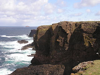
The Mainland is the main island of Shetland, Scotland. The island contains Shetland's only burgh, Lerwick, and is the centre of Shetland's ferry and air connections.

<span class="mw-page-title-main">Mainland, Orkney</span> Main island of the Orkney Islands, Scotland

The Mainland, also known as Hrossey and Pomona, is the main island of Orkney, Scotland. Both of Orkney's burghs, Kirkwall and Stromness, lie on the island, which is also the heart of Orkney's ferry and air connections.

<span class="mw-page-title-main">Tidal island</span> Island accessible by foot at low tide

A tidal island is a piece of land that is connected to the mainland by a natural or man-made causeway that is exposed at low tide and submerged at high tide. Because of the mystique surrounding tidal islands, many of them have been sites of religious worship, such as Mont-Saint-Michel with its Benedictine Abbey. Tidal islands are also commonly the sites of fortresses because of their natural fortifications.

<span class="mw-page-title-main">Hinnøya</span> Large island of Troms and Nordland, Norway

Hinnøya is the fourth-largest island in Norway, and the largest outside the Svalbard archipelago. The 2,204.7-square-kilometre (851.2 sq mi) lies just off the western coast of Northern Norway. The island sits on the border of Nordland and Troms og Finnmark counties. The western part of the island is in the district of Vesterålen, the southwestern part is in the Lofoten district, the southeastern part is in the Ofoten district, and the northeastern part is in Troms. As of 2017, Hinnøya had a population of 32,688. The only town on the island is the town of Harstad. Some of the larger villages include Borkenes, Lødingen, Sigerfjord, and Sørvik. The island is split between the municipalities of Harstad, Tjeldsund and Kvæfjord in Troms og Finnmark county, as well as Andøy, Hadsel, Lødingen, Sortland, and Vågan in Nordland county.

<span class="mw-page-title-main">Carey Island</span> Island in Malaysia

Carey Island is an island in Selangor, Malaysia. It is administered by the Zone 17 of the Kuala Langat Municipal Council. Carey Island is located to the south of Port Klang and north of Banting town. It is a huge island separated from the Selangor coast by the Langat River, connected by two bridges from Chodoi and Teluk Panglima Garang near Banting and a bridge from Pulau Indah and Pulau Carey.

<span class="mw-page-title-main">Great Wass Island</span>

Great Wass Island lies in the Atlantic Ocean off the coast of the State of Maine, United States. On the mainland is Jonesport in Washington County. The island is 5 mi (8 km) long, 1.5 mi (2.5 km) wide and it is the biggest island in the Great Wass Archipelago, which contains over 43 islands extending off the coast from Jonesport. Great Wass Island is connected with a bridge to Beals Island, which is then connected to the mainland. Head Harbor Island and Steels Harbor Island lie close to the east. The 1,450-acre (5.9 km2) Great Wass Island Preserve is in the island. The interior of Great Wass Island supports coastal Maine's largest stand of jack pine, other typical plants are bakeapple, deer-hair sedge, and dragon's mouth orchid. The island is part of the Town of Beals, in Washington County.

<span class="mw-page-title-main">Holsnøy</span>

Holsnøy is an island in Alver Municipality in Vestland county, Norway. The 88.8-square-kilometre (34.3 sq mi) island lies to the north/west of the mainland, between the islands of Radøy to the north and Askøy to the south. The highest point on the island is the 324-metre (1,063 ft) tall Eldsfjellet, a mountain located about 2 kilometres (1.2 mi) north of the village of Rossland. The island is hilly and marshy, with the majority of the residents living along the southern shore. The largest settlement on the island is the village of Frekhaug on the southern shore.

<span class="mw-page-title-main">Tied island</span> Island that is connected to land only by a tombolo

Tied islands, or land-tied islands as they are often known, are landforms consisting of an island that is connected to mainland or another island only by a tombolo: a spit of beach materials connected to land at both ends. St Ninian's Isle in the Shetland Islands off the north coast of Scotland is an example since it was once an island but is now linked to the mainland. Other examples include Maury Island, Washington, in the Puget Sound, Coronado, California; and Nahant, Massachusetts in the United States; Barrenjoey, New South Wales, in Australia; Paratutae Island, in New Zealand; Mount Hakodate in Japan, Howth Head, in Ireland; Wedge Island, in Western Australia; Cheung Chau, in Hong Kong; and Davaar Island, Campbeltown, Scotland.

<span class="mw-page-title-main">Fraoch-Eilean</span>

Fraoch-eilean is a small island with an uncertain population north of Benbecula in the Outer Hebrides of Scotland. It is about 55 hectares in extent and the highest point is 11 metres (36 ft). Its name derives from the Gaelic for "heather island".

<span class="mw-page-title-main">Madre de Deus, Bahia</span> Municipality in Nordeste, Brazil

Madre de Deus is a municipality in the state of Bahia in the North-East region of Brazil. The municipality is located on a small archipelago in the Bay of All Saints; it both the smallest municipality by land mass in Bahia and the Northeastern region of Brazil. Madre de Deus is spread across two islands, the Ilha de Madre de Deus and the much smaller Ilha de Maria Guarda. It sits in close proximity to two others islands, the Ilha do Bom Jesus dos Passos and Ilha dos Frades, both part of the city of Salvador. The Ilha de Madre de Deus is further subdivided into the neighborhoods of Centro, Suape, Cação, Marezinha, Mirim, Alto do Paraíso, Apicum, Nova Madre de Deus e Quitéria, Alto da Matriz, Alto do Santo Antônio, Alto da Boa Vista, Cururupeba, Malvinas, and Nova Brasília.

<span class="mw-page-title-main">Gatas (Ponce)</span> Small island of Ponce, Puerto Rico

Gatas or, more commonly, Isla de Gatas, is a small island in barrio Playa in the municipality of Ponce in southern Puerto Rico. A tied island since the 1950s connected to the Puerto Rico mainland via a tombolo, Isla de Gatas is home to Club Náutico de Ponce, a private sports complex. It is located south of La Guancha and the Port of Ponce. Together with Caja de Muertos, Morrillito, Ratones, Cardona, Isla del Frio, and Isla de Jueyes, Gatas is one of seven islands in the municipality of Ponce.

<span class="mw-page-title-main">Inishkeel</span> Irish monastery

Inishkeel is a small tidal island and a townland off the coast of County Donegal, Ireland. The closest village on the mainland is Narin.