East Hampton, Connecticut

Last updated

East Hampton, Connecticut
Town of East Hampton
The East Hampton Bank and Trust Co, East Hampton CT.jpg
The East Hampton Bank and Trust Company Building
East Hampton, CT Seal.jpg
Nickname(s): 
Belltown, USA
East Hampton, Connecticut
Coordinates: 41°34′N72°30′W / 41.567°N 72.500°W / 41.567; -72.500
CountryFlag of the United States (23px).png  United States
U.S. state Flag of Connecticut.svg  Connecticut
County Middlesex
Region Lower CT River Valley
Incorporated1767
Government
  Type Council-manager
  CouncilMark Philhower (R), Chair
Tim Feegel (R), Vice-Chair
Pete Brown (D)
Brandon Goff (R)
Eric Peterson (R)
Kevin Reich (D)
Alison Walck (R)
  Town ManagerDavid E. Cox
Area
  Total36.8 sq mi (95.3 km2)
  Land35.6 sq mi (92.2 km2)
  Water1.2 sq mi (3.2 km2)
Elevation
[1]
417 ft (127 m)
Population
 (2020)
  Total12,717
  Density357/sq mi (137.9/km2)
Time zone UTC-5 (Eastern)
  Summer (DST) UTC-4 (Eastern)
ZIP code
06424, 06414, 06456
Area code(s) 860/959
FIPS code 09-22490
GNIS feature ID0213423 [1]
Website www.easthamptonct.gov

East Hampton is a town in Middlesex County, Connecticut, United States. The town is part of the Lower Connecticut River Valley Planning Region. The population was 12,717 at the 2020 census. [2] The town center village is listed as a census-designated place (CDP). East Hampton includes the communities of Cobalt, Middle Haddam, and Lake Pocotopaug.

Contents

The southern trailhead of the Shenipsit Trail is in Cobalt, and the Airline State Park (a rail trail) has its southern trailhead in East Hampton, at Main Street in the Village Center. The 884-acre (358 ha) Hurd State Park, Meshomasic State Forest, and Salmon River State Forest are located in town. Comstock's Bridge, more commonly known as the Comstock Covered Bridge and the only remaining covered bridge in eastern Connecticut, spans the Salmon River near Route 16 in East Hampton.

The Chatham Historical Society Museum and the Joseph N. Goff House Museum and Cultural Center are located in the town.

History

The first European-derived settlers of the area arrived in 1739 by sea from Eastham, Massachusetts. They traveled up the Connecticut River to Middle Haddam parish between the two adjacent towns of Middletown and Haddam. Led by Isaac Smith, some of these settlers went on to the hills near Lake Pocotopaug, the present-day location of East Hampton. In 1746, the settlers named their community Easthampton parish after their former home of Eastham. In 1767, the community was separated from Middletown incorporated by the Connecticut General Assembly as the township of Chatham, after Chatham, Medway due to the important shipbuilding industries that both places had in common. An iron forge at the outlet of Lake Pocotopaug was one of the earliest in Connecticut. The forge supplied the local needs and the shipbuilding industry on the banks of the Connecticut River. Shipbuilding up the Connecticut River was given a boost during the War of 1812 when the British raided a town at the mouth of the Connecticut River. The knowledge gained in forging and casting iron was later used for creating other items including waffle irons. Bell making continued to grow during the 1800s with firms utilizing the water power of the Pocotopaug Stream. After the Civil War numerous coffin trimming concerns lined the stream. Some firms changed focus over time such as the Watrous Mfg. Co. which started making just bells, later making coffin trimmings, and still later making bell toys.

Summit Thread Company, 1906 PostcardEastHamptonCTFactory1908.jpg
Summit Thread Company, 1906
Railroad station, c. 1907 PostcardEastHamptonCTRailroadSta1907.jpg
Railroad station, c.1907
Main Street, c. 1907 PostcardEastHamptonCTMainStLookingNorth1907.jpg
Main Street, c.1907

In the 19th century, East Hampton became the center of the manufacturing of bells. So many bells were made in East Hampton that the town was given the name BellTown. The first factory was constructed in 1808 by William Barton on Bevin Hill later renamed Barton Hill. During the 1800s, thirty firms were said to have built and run shops, or small factories producing bell and bell related products. The most prominent names include William Barton and the numerous Barton companies of his sons, Bevin Brothers Manufacturing Company, [note 1] Starr Bros. Bell Co., The N. N. Hill Brass Co., The East Hampton Bell Co., Watrous Mfg. Co., Veazey and White, and Gong Bell.

The bell companies that dominated the economy of East Hampton by making metal bells continued to flourish until horses and buggy transportation (and the bells used to adorn their harnesses) gave way to automobiles. The Great Depression also negatively impacted manufacturing in the area. Two firms continued to flourish into the 1950s by changing from making predominantly metal bells with bell toys being a minor part of their production in the 1800s, to primarily making bell toys. These two firms N. N. Hill Brass Co. and Gong Bell Mfg. Co., survived till the 1960s. The last remaining original operating bell shop, operated by Bevin Brothers, was razed by fire on May 27, 2012, but continues in full operation in a new East Hampton location; some other structures shut down while still structurally intact but remained unavailable for adaptive re-use, due to the presence of toxic substances at levels that resist remediation. Other mills, which were remediated or did not contain toxics, have been converted into offices, stores, and other small businesses.

In 1841, the East Middletown parish, which had been a part of Chatham, separated and became a new township called Conway (later renamed to Portland).

Chatham was renamed to East Hampton in 1915, which had long been a second name for the township. The name "East Hampton", however, is confusing, since the town is, in fact, approximately 30 miles (48 km) southwest of Hampton, Connecticut. In addition, there is often confusion between East Hampton and the contiguous town of East Haddam, which was named in 1734.

Capt. Jesse Hurd was a master ship builder in Middle Haddam after the Revolutionary War until his death in 1839. Interest in ship building in Middle Haddam dwindled thereafter. Captain Hurd was also the owner and creator of the New York Screw Dock Company, a "dry dock" facility for ship repairs.

Geography

According to the United States Census Bureau, the town has a total area of 36.8 square miles (95 km2), of which, 35.6 square miles (92 km2) of it is land and 1.2 square miles (3.1 km2) of it (3.37%) is water, due to the large Lake Pocotopaug, which used to be inhabited by Native American tribes. The town center CDP has a total area of 2.6 square miles (6.7 km2). 2.5 square miles (6.5 km2) of it is land and 0.04 square miles (0.10 km2) of it (0.78%) is water.

Demographics

Historical population
CensusPop.Note
1790 3,230
1800 3,2952.0%
1810 3,258−1.1%
1820 3,159−3.0%
1830 3,64615.4%
1840 3,413−6.4%
1850 1,525−55.3%
1860 1,76615.8%
1870 2,77156.9%
1880 1,967−29.0%
1890 1,949−0.9%
1900 2,27116.5%
1910 2,3905.2%
1920 2,3940.2%
1930 2,6169.3%
1940 2,95513.0%
1950 4,00035.4%
1960 5,40335.1%
1970 7,07831.0%
1980 8,57221.1%
1990 10,42821.7%
2000 13,35228.0%
2010 12,959−2.9%
2020 12,717−1.9%
U.S. Decennial Census [3]

At the 2000 census there were 13,352 people, 4,126 households, and 3,003 families living in the town. The population density was 375.2 inhabitants per square mile (144.9/km2). There were 4,412 housing units at an average density of 124.0 per square mile (47.9/km2). The racial makeup of the town was 93.36% White, 2.04% Black or African American, 0.19% Native American, 2.39% Asian, 0.05% Pacific Islander, 0.44% from other races, and 1.51% from two or more races. Hispanic or Latino of any race were 1.69%. [4]

Of the 4,126 households 36.6% had children under the age of 18 living with them, 60.7% were married couples living together, 8.5% had a female householder with no husband present, and 27.2% were non-families. 20.5% of households were one person and 5.5% were one person aged 65 or older. The average household size was 2.63 and the average family size was 3.07.

The age distribution was 21.4% under the age of 18, 22.4% from 18 to 24, 27.0% from 25 to 44, 21.3% from 45 to 64, and 7.9% 65 or older. The median age was 32 years. For every 100 females, there were 99.0 males. For every 100 females age 18 and over, there were 96.8 males.

The median household income was $66,326 and the median family income was $74,409. Males had a median income of $50,157 versus $35,867 for females. The per capita income for the town was $22,769. About 2.2% of families and 3.7% of the population were below the poverty line, including 2.7% of those under age 18 and 8.0% of those age 65 or over.

Town center

At the 2000 census there were 2,254 people, 821 households, and 596 families living in the East Hampton CDP. The population density was 883.0 inhabitants per square mile (340.9/km2). There were 858 housing units at an average density of 336.1 per square mile (129.8/km2). The racial makeup of the CDP was 97.96% White, 0.80% Black or African American, 0.13% Native American, 0.58% Asian, 0.04% from other races, and 0.49% from two or more races. Hispanic or Latino of any race were 0.67%. [4]

Of the 821 households 37.1% had children under the age of 18 living with them, 58.6% were married couples living together, 9.9% had a female householder with no husband present, and 27.3% were non-families. 20.0% of households were one person and 5.2% were one person aged 65 or older. The average household size was 2.70 and the average family size was 3.15.

The age distribution was 27.3% under the age of 18, 6.0% from 18 to 24, 33.4% from 25 to 44, 23.3% from 45 to 64, and 9.9% 65 or older. The median age was 37 years. For every 100 females, there were 96.9 males. For every 100 females age 18 and over, there were 93.2 males.

The median household income was $53,464 and the median family income was $64,150. Males had a median income of $50,727 versus $31,181 for females. The per capita income for the CDP was $25,207. About 1.2% of families and 4.1% of the population were below the poverty line, including 2.7% of those under age 18 and 2.8% of those age 65 or over.

Historic sites

Historic sites in East Hampton include the following three sites listed on the National Register of Historic Places:

Notable people

Notes

  1. The historic 1880s Bevin factory located off Bevin Boulevard was destroyed by fire in 2012. As of 2017, the company operates out of rented space on Watrous Street, in a building once occupied by the woodworking shop of Gong Bell, using bell molds salvaged from the fire and refurbished presses.

Related Research Articles

<span class="mw-page-title-main">Middlesex County, Connecticut</span> County in Connecticut, United States

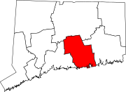
Middlesex County is a county in the south central part of the U.S. state of Connecticut. As of the 2020 census, the population was 164,245. The county was created in May 1785 from portions of Hartford County and New London County.

<span class="mw-page-title-main">Broad Brook, Connecticut</span> Census-designated place in Connecticut, United States

Broad Brook is a neighborhood and census-designated place (CDP) in the town of East Windsor, Hartford County, Connecticut, United States. As of the 2010 census, the CDP population was 4,069.

<span class="mw-page-title-main">Kensington, Connecticut</span> Census-designated place in Connecticut, United States

Kensington is a census-designated place (CDP) and section of the town of Berlin in Hartford County, Connecticut, United States. The Berlin town offices are located in Kensington. The population was 8,459 at the 2010 census.

<span class="mw-page-title-main">Thompsonville, Connecticut</span> Census-designated place in Connecticut, United States

Thompsonville is a census-designated place (CDP) in the town of Enfield in Hartford County, Connecticut, United States. The population of the CDP was 8,577 at the 2010 census.

<span class="mw-page-title-main">Chester, Connecticut</span> Town in Connecticut, United States

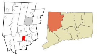
Chester is a town in Middlesex County, Connecticut, United States. The town is part of the Lower Connecticut River Valley Planning Region. The population was 3,749 at the 2020 census. The town center is defined by the U.S. Census Bureau as a census-designated place (CDP). The name is a transfer from Chester, in England.

<span class="mw-page-title-main">East Haddam, Connecticut</span> Town in Connecticut, United States

East Haddam is a town in Middlesex County, Connecticut. The town is part of the Lower Connecticut River Valley Planning Region. The population was 8,875 at the time of the 2020 census.

<span class="mw-page-title-main">Higganum, Connecticut</span> Census-designated place in Connecticut, United States

Higganum is a village and census-designated place (CDP) in the town of Haddam, a part of Middlesex County, Connecticut, United States. The population was 2,089 at the 2020 census.

<span class="mw-page-title-main">Moodus, Connecticut</span> Census-designated place in Connecticut, United States of America

Moodus is a village in the town of East Haddam, Connecticut, United States. The village is the basis of a census-designated place (CDP) of the same name. The population of the CDP was 1,982 as of the census of 2020.

<span class="mw-page-title-main">Westbrook, Connecticut</span> Town in Connecticut, United States

Westbrook is a town in Middlesex County, Connecticut, United States. The town is part of the Lower Connecticut River Valley Planning Region. The population was 6,769 at the 2020 census. The town center is classified by the U.S. Census Bureau as a census-designated place (CDP).

<span class="mw-page-title-main">East Brooklyn, Connecticut</span> Census-designated place in Connecticut, United States

East Brooklyn is a census-designated place (CDP) located within the town of Brooklyn in Windham County, Connecticut. It is the portion of the Danielson urban cluster within the town of Brooklyn. The population was 2,205 at the 2020 census. US 6 runs through the town and severs the town.

<span class="mw-page-title-main">East Harwich, Massachusetts</span> Census-designated place in Massachusetts, United States

East Harwich is a census-designated place (CDP) and village in the town of Harwich in Barnstable County, Massachusetts, United States. The population was 4,872 at the 2010 census.

<span class="mw-page-title-main">West Chatham, Massachusetts</span> Census-designated place in Massachusetts, United States

West Chatham is a census-designated place (CDP) in the town of Chatham in Barnstable County, Massachusetts, United States. The population was 1,410 at the 2010 census.

<span class="mw-page-title-main">Lake Pocotopaug, Connecticut</span> Census-designated place in Connecticut, United States

Lake Pocotopaug is an unincorporated village and census-designated place (CDP) in the town of East Hampton in Middlesex County, Connecticut, United States. As of the 2020 census, it had a population of 4,901, up from 3,436 in 2010.

<span class="mw-page-title-main">Hampton Manor, New York</span> CDP in New York, United States

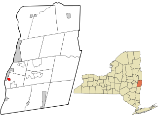
Hampton Manor is a census-designated place in the town of East Greenbush in Rensselaer County, New York, United States. The population was 2,417 at the 2010 census.

<span class="mw-page-title-main">Northwest Harbor, New York</span> Census-designated place in New York, United States

Northwest Harbor is a hamlet and census-designated place (CDP) in the Town of East Hampton, Suffolk County, New York, United States. The population was 3,317 at the 2010 census.

<span class="mw-page-title-main">Hampton (CDP), New Hampshire</span> Census-designated place in New Hampshire, United States

Hampton is a census-designated place (CDP) comprising the town center and surrounding developed areas of the town of Hampton, Rockingham County, New Hampshire, United States. The population of the CDP was 9,597 at the 2020 census, out of 16,214 in the entire town.

<span class="mw-page-title-main">Durham, Connecticut</span> Town in Connecticut, United States

Durham is a town in Middlesex County, Connecticut, United States. Durham is a former farming village on the Coginchaug River in central Connecticut. The town is part of the Lower Connecticut River Valley Planning Region. The population was 7,152 at the 2020 census. Every autumn, the town hosts the Durham Fair, the largest volunteer agricultural fair in New England.

<span class="mw-page-title-main">Bethlehem Village, Connecticut</span> Census-designated place in Connecticut, United States

Bethlehem Village is a census-designated place (CDP) within the town of Bethlehem in Litchfield County, Connecticut, United States. The CDP includes the Bethlehem Green Historic District at the town center, as well as surrounding residential and rural land. As of the 2010 census, the CDP had a population of 2,021, out of a population of 3,607 for the entire town of Bethlehem.

<span class="mw-page-title-main">Clinton, Connecticut</span> Town in Connecticut, United States

Clinton is a town in Middlesex County, Connecticut, United States. The town is part of the Lower Connecticut River Valley Planning Region. The population of the town was 13,185 at the 2020 census. The town center along the shore line was listed as a census-designated place (CDP) by the U.S. Census Bureau in the 2020 census.

<span class="mw-page-title-main">Portland, Connecticut</span> Town in Connecticut, United States

Portland is a town in Middlesex County, Connecticut, United States. The town is part of the Lower Connecticut River Valley Planning Region. The population was 9,384 at the 2020 census. The town center is listed as a census-designated place (CDP). It is situated across the Connecticut River from Middletown.

References

  1. 1 2 U.S. Geological Survey Geographic Names Information System: East Hampton, Connecticut
  2. "Census - Geography Profile: East Hampton town, Middlesex County, Connecticut" . Retrieved December 15, 2021.
  3. "Census of Population and Housing". Census.gov. Retrieved June 4, 2015.
  4. 1 2 "U.S. Census website". United States Census Bureau . Retrieved January 31, 2008.