History
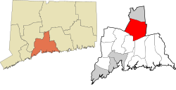
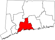
The Connecticut General Assembly created the town on October 10, 1667. This original plot of land near the Quinnipiac River is now considered Main Street. Starting on May 12, 1670, there were 126 people who lived in temporary housing, and five years later in 1675 there were 40 permanent homes. [4]
In 1697 Wallingford was the site of the last witchcraft trial in New England. Winifred Benham was thrice tried for witchcraft and acquitted all three times. [5]
The 1878 Wallingford tornado struck on August 9 of that year. It killed at least 29 and possibly as many as 34 people in Wallingford, the most by any tornado event in Connecticut history.
Wallingford is home to a large variety of industries and major corporations spanning the spectrum of medical, healthcare, service, hi-tech specialty manufacturing and research development. The development of the Barnes Industrial Parks, Casimir Pulaski Industrial Park, Centract Park and MedWay Industrial Park have greatly contributed to a diversified tax base. An Interchange Zone which permits restrictive commercial development of office parks, research and development centers and hotels was created at the intersection of interstate 91 and Route 68. [6] The Bristol-Myers Squibb Company, the town's largest taxpayer, has established a research and development facility in Wallingford's MedWay Industrial Park. The Bristol-Myers Squibb Company moved out in 2017 and the structures were demolished in 2018.
In terms of Wallingford's manufacturing and design history, silver-producing companies like Hall, Elton & Co., [7] Simpson, Hall, Miller & Co. [8] and R. Wallace & Sons are of particular note. [9] Simpson, Hall, Miller & Co. as well as Wallingford's Watrous Manufacturing Co. later became part of the International Silver Company, which was headquartered in the neighboring city of Meriden. [10]
Demographics
Historical population| Census | Pop. | Note | %± |
|---|
| 1820 | 2,237 | | — |
|---|
| 1850 | 2,595 | | — |
|---|
| 1860 | 3,206 | | 23.5% |
|---|
| 1870 | 3,676 | | 14.7% |
|---|
| 1880 | 4,686 | | 27.5% |
|---|
| 1890 | 6,584 | | 40.5% |
|---|
| 1900 | 9,001 | | 36.7% |
|---|
| 1910 | 11,155 | | 23.9% |
|---|
| 1920 | 12,010 | | 7.7% |
|---|
| 1930 | 14,278 | | 18.9% |
|---|
| 1940 | 14,788 | | 3.6% |
|---|
| 1950 | 16,976 | | 14.8% |
|---|
| 1960 | 29,920 | | 76.2% |
|---|
| 1970 | 35,714 | | 19.4% |
|---|
| 1980 | 37,274 | | 4.4% |
|---|
| 1990 | 40,822 | | 9.5% |
|---|
| 2000 | 43,026 | | 5.4% |
|---|
| 2010 | 45,135 | | 4.9% |
|---|
| 2020 | 44,396 | | −1.6% |
|---|
|
As of 2022, Wallingford is home to approximately 44,446 residents. The racial makeup leans white (80.2%), with a notable Hispanic presence (11.6%) and smaller proportions of Asian (4.4%) and other groups. The median age sits at 44.3, indicating a blend of families and young professionals. Family households comprise 63% of the total, with 24% having children under their roof. [16]
Wallingford’s 2022 median household income was $98,456, and the median family income was $120,823. [17] The average household and family income was $115,652 and $139,258, respectively. [18] Compared to the national average, Wallingford's median income is significantly higher, putting it in the top 25% of U.S. households.

New Haven is a city in New Haven County, Connecticut, United States. It is located on New Haven Harbor on the northern shore of Long Island Sound and is part of the New York City metropolitan area. With a population of 135,081 as determined by the 2020 U.S. census, New Haven is the third largest city in Connecticut after Bridgeport and Stamford, the largest city in the South Central Connecticut Planning Region, and the principal municipality of Greater New Haven, which had a total population of 864,835 in 2020. Prior to 1960, it was the county seat of New Haven County until the county governments were abolished that year.

New Haven County is a county in the south central part of the U.S. state of Connecticut. As of the 2020 census, the population was 864,835, making it the third-most populous county in Connecticut. Two of the state's top 5 largest cities, New Haven (3rd) and Waterbury (5th), are part of New Haven County.

Cheshire, formerly known as New Cheshire Parish, is a town in New Haven County, Connecticut, United States. At the time of the 2020 census, the population of Cheshire was 28,733. The town is part of the Naugatuck Valley Planning Region. The center of population of Connecticut is located in Cheshire.

Hamden is a town in New Haven County, Connecticut, United States. The town's nickname is "The Land of the Sleeping Giant". The town is part of the South Central Connecticut Planning Region. The population was 61,169 at the 2020 census.

Meriden is a city in New Haven County, Connecticut, United States, located halfway between the regional cities of New Haven and Hartford. The city is part of the South Central Connecticut Planning Region. In 2020, the population of the city was 60,850.

The Quinnipiac River is a 45.5-mile (73.2 km) long river in the New England region of the United States, located entirely in the state of Connecticut.

North Haven is a town in New Haven County, Connecticut on the outskirts of New Haven, Connecticut. The town is part of the South Central Connecticut Planning Region. As of the 2020 census, it had a population of 24,253.

Yalesville is an unincorporated village in Wallingford, Connecticut, United States. The village was founded in 1677, and was originally called "First Falls". It was renamed Yalesville in 1808.

Route 150 is a state highway in southern Connecticut running for 9.04 miles (14.55 km) from the village of Northford, in the town of North Branford, through the center of Wallingford, to the village of Yalesville in Wallingford.

U.S. Route 5 (US 5), a north–south United States Numbered Highway that is generally paralleled by Interstate 91 (I-91), begins at the city of New Haven in Connecticut and heads north through western Massachusetts and eastern Vermont to the international border with Canada. Within Connecticut, US 5 proceeds north from New Haven and passes through Meriden and Hartford toward Springfield, Massachusetts.

Choate Rosemary Hall is a private, co-educational, college-preparatory boarding school in Wallingford, Connecticut, United States. Founded in 1890, it took its present name and began a co-educational system with the 1971 merger of The Choate School for boys and Rosemary Hall for girls. It is part of the Eight Schools Association and the Ten Schools Admissions Organization.

William Gardner Choate was a United States district judge of the United States District Court for the Southern District of New York. He also cofounded the Choate Rosemary Hall college, a private boarding school in Wallingford, Connecticut.
Whitney Avenue is a principal arterial connecting Downtown New Haven with the town center of Hamden in the U.S. state of Connecticut. Most of the road within the city of New Haven is included in the Whitney Avenue Historic District, which is listed on the National Register of Historic Places. The designation begins at Grove Street in the northern part of Downtown New Haven and extends through the town of Hamden up to the Cheshire town line. North of Dixwell Avenue in Hamden Center, the road is a state highway and designated as part of Route 10. From the New Haven town line to Dixwell Avenue, the road is state-maintained with an unsigned designation of State Road 707. Within New Haven, Whitney Avenue is a town road. The J route of Connecticut Transit New Haven, which connects New Haven to Waterbury, runs along Whitney Avenue.

Rosemary Hall was an independent girls school at Ridgeway and Zaccheus Mead Lane in Greenwich, Connecticut. It was later merged into Choate Rosemary Hall and moved to the Choate boys' school campus in Wallingford, Connecticut.

The Meriden Britannia Company was formed in 1852 in Meriden, Connecticut, as a manufacturing company focused on producing wares in britannia metal. It became, for a time, the largest silverware company in the world.

Simpson, Hall, Miller & Co. was a cutlery and silver hollowware manufacturer in Wallingford, Connecticut, founded in 1866. By c. 1895, the company operated large factories in Wallingford and Montreal, Canada.
R. Wallace & Sons was formed in Wallingford, Connecticut, and incorporated in 1879. As of 1893, this company manufactured silver and plated ware and cutlery and had about 600 employees.
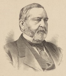
Charles Dwight Yale, of Wallingford, Connecticut, was a Democratic Senator and businessman, co-proprietor of Simpson, Hall, Miller & Co.. During the Reconstruction era, he played a leading role in mediating conflicts between Virginia and the Union States.

William Yale was a tin ware merchant, politician, Justice of the Peace, and the largest manufacturer in Meriden, Connecticut. He was the oldest son of Revolutionary War patriot Samuel Yale Sr., founder of the Yale manufacturing dynasty of Connecticut. He also served in the Connecticut State House of Representatives from Meriden in 1825, and did business with the Griswolds. His entreprises were succeeded by his son, Gen. Edwin R. Yale, proprietor of the U.S. Hotel and Mansion House in New York.

William Yale Beach was a banker and businessman from Connecticut, son of penny press pioneer Moses Yale Beach. His private bank was the first banking institution of Wallingford, and the largest in the city. He also did business with the freemasons and developed number of streets in Wallingford.