Hartford County is a county located in the north central part of the U.S. state of Connecticut. According to the 2020 census, the population was 899,498, making it the second-most populous county in Connecticut. Hartford County contains the city of Hartford, the state capital of Connecticut and the county's most populous city, with 121,054 residents at the 2020 census. Hartford County is included in the Hartford-East Hartford-Middletown metropolitan statistical area.

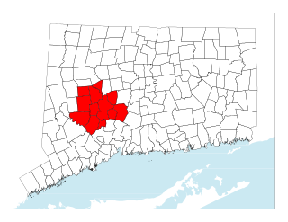
Litchfield County is in northwestern Connecticut, United States. As of the 2020 census, the population was 185,186. The county was named after Lichfield, in England. Litchfield County has the lowest population density of any county in Connecticut and is the state's largest county by area.

New Haven County is a county in the south central part of the U.S. state of Connecticut. As of the 2020 census, the population was 864,835, making it the third-most populous county in Connecticut. Two of the state's top 5 largest cities, New Haven (3rd) and Waterbury (5th), are part of New Haven County.

Bethlehem is a town in Litchfield County, Connecticut, United States. The population was 3,385 at the 2020 census, down from 3,607 at the 2010 census. The town is part of the Naugatuck Valley Planning Region. The town center is a historic district and a census-designated place (CDP).

Bridgewater is a town in Litchfield County, Connecticut, United States. The population was 1,662 at the 2020 census, down from 1,727 at the 2010 census. The town is part of the Western Connecticut Planning Region.

Harwinton is a town in Litchfield County, Connecticut, United States. The population was 5,484 at the 2020 census. The town is part of the Northwest Hills Planning Region. The high school is Lewis S. Mills.

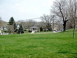
Northwest Harwinton is a census-designated place (CDP) in the town of Harwinton in Litchfield County, Connecticut, United States. The population was 3,158 at the 2020 census, out of 5,484 in the entire town. The CDP contains the town center.

Oakville is a census-designated place (CDP) and neighborhood section of Watertown, in Litchfield County, Connecticut, United States. The population was 9,047 as of the 2010 census. It is the most populous community in Watertown, with more than twice as many people as the center village of Watertown. The ZIP code for Oakville is 06779.
Plymouth is a town in Litchfield County, Connecticut, United States. It is named after Plymouth, Devon, England. The population was 11,671 at the 2020 census, down from 12,243 at the 2010 census. The town of Plymouth includes the villages of Plymouth Center, Terryville and Pequabuck.

Roxbury is a town in Litchfield County, Connecticut, United States. The population was 2,260 at the 2020 census. The town is located 65 miles (105 km) northeast of New York City, and is part of the Northwest Hills Planning Region.

Thomaston is a town in Litchfield County, Connecticut, United States. The town is part of the Naugatuck Valley Planning Region. The population was 7,442 at the 2020 census. The urban center of the town is the Thomaston census-designated place, with a population of 1,928 at the 2020 census.

Warren is a town in Litchfield County, Connecticut, United States. The population was 1,351 at the 2020 census. The town is part of the Northwest Hills Planning Region. The town was named for Revolutionary War General Joseph Warren.

Winchester is a town in Litchfield County, Connecticut, United States. The population was 10,224 at the 2020 census. The city of Winsted is located in Winchester. The town is part of the Northwest Hills Planning Region.

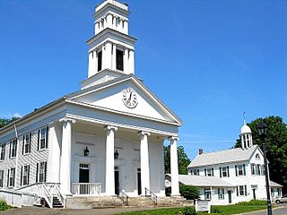
Woodbury is a town in Litchfield County, Connecticut, United States. The town is part of the Naugatuck Valley Planning Region. The population was 9,723 at the 2020 census. The town center, comprising the adjacent villages of Woodbury and North Woodbury, is designated by the U.S. Census Bureau as the Woodbury Center census-designated place (CDP). Woodbury was founded in 1673.

Middlebury is a town in New Haven County, Connecticut, United States. The population was 7,574 at the 2020 census. The town is part of the Naugatuck Valley Planning Region.

Oxford is a residential town located in western New Haven County, Connecticut, United States. The town is part of the Naugatuck Valley Planning Region. The population was 12,706 at the 2020 Census. Oxford is the 26th-wealthiest town in the state by median household income. Distinct settled areas in the town include Oxford Center, Quaker Farms, and Riverside. Oxford belongs to the Bridgeport–Stamford–Norwalk Metropolitan Statistical Area, a subregion of the New York metropolitan area.
The Naugatuck River Valley is the watershed area of the Naugatuck River in the western part of Connecticut. The Naugatuck Valley straddles parts of Litchfield County, New Haven, and Fairfield counties. The Route 8 corridor and Waterbury Branch of the Metro-North railroad line run along the river valley. Geographically, it comprises the municipalities located within the Naugatuck River basin. During the 19th and 20th centuries, the area was one of the main manufacturing centers in New England, and most of the communities around the river were emblematic New England mill towns.
The Central Naugatuck Valley is a region of Connecticut in New Haven and Litchfield counties located approximately 70 miles (110 km) northeast of New York City and 110 miles (180 km) southwest of Boston, United States. The region comprises 13 towns: Beacon Falls, Bethlehem, Cheshire, Middlebury, Naugatuck, Oxford, Prospect, Southbury, Thomaston, Waterbury, Watertown, Wolcott, and Woodbury.

Watertown is a census-designated place (CDP) in Litchfield County, Connecticut, United States. It comprises the central village of the town of Watertown. As of the 2010 census, the population of the CDP was 3,574, out of 22,514 in the entire town. As of the 2020 Census, the population was 22,105.

Thomaston is a census-designated place (CDP) in Litchfield County, Connecticut, United States. It comprises the downtown portion of the town of Thomaston. As of the 2010 census, the population of the CDP was 1,910, out of 7,887 in the entire town.