Sherman, Connecticut

Last updated

Sherman, Connecticut
Town of Sherman
OldTownHallShermanCT.jpg
1886 Town Hall
ShermanCTSeal.png
Fairfield County Connecticut incorporated and unincorporated areas Sherman highlighted.svg
Sherman, Connecticut
Coordinates: 41°35′N73°30′W / 41.583°N 73.500°W / 41.583; -73.500
CountryFlag of the United States.svg  United States
U.S. state Flag of Connecticut.svg  Connecticut
County Fairfield
Region Western CT
Incorporated1802
Government
  Type Selectman-town meeting
  First selectmanDon Lowe (D)
  SelectmanJoel Bruzinski (D)
  SelectmanBob Ostrosky (R)
Area
  Total23.4 sq mi (60.6 km2)
  Land21.8 sq mi (56.5 km2)
  Water1.6 sq mi (4.0 km2)
Elevation
466 ft (142 m)
Population
 (2020)
  Total3,527
  Density150/sq mi (58/km2)
Time zone UTC-5 (Eastern)
  Summer (DST) UTC-4 (Eastern)
ZIP Code
06784
Area code(s) 860/959
FIPS code 09-68310
GNIS feature ID0213505
Website www.townofshermanct.org

Sherman is the northernmost and least populous town of Fairfield County, Connecticut, United States. The population was 3,527 at the 2020 census. [1] The town is part of the Western Connecticut Planning Region. The town was formed in 1802 from the northern part of New Fairfield. It is named for Roger Sherman, the only person who signed all four founding documents of the United States of America. [2] He also had a cobblers shop in the north end of town which has been reconstructed behind the Northrup House in the center of town.

Contents

Sherman has been named "Best Small Town in Connecticut" three times by Connecticut Magazine .

The Appalachian Trail goes through the northern end of Sherman. Part of Squantz Pond is in the town.

Sherman is a popular weekend retreat for New York City residents, with about a third of its residents weekenders. The town is located 62 miles (100 km) northeast of New York City, making it part of the New York metropolitan area. [3]

Sherman has one area on the National Register of Historic Places: the Sherman Historic District, bounded roughly by the intersection of Old Greenswood Road and Route 37, northeast past the intersection of Route 37 East and Route 39 North and Sawmill Road. The district was added to the National Register on August 31, 1991.

Sherman is the only town in Fairfield County in the 860 area code; the remainder of the county is served by the area code 203/area code 475 overlay.

History

The land which is now called Sherman was formerly occupied primarily by native people of Algonquian lineage.

In 1724, colonial settlers from Fairfield, Connecticut, received approval from the General Assembly of the Colony of Connecticut to establish a new township. According to one account, they negotiated with Chief Squantz of the Schaghticoke tribe. Alternatively, it is told that they did not negotiate with Chief Squantz because he moved to the north end of Squantz Pond land area and refused to "sell" the township of New Fairfield. They returned in the spring of 1725, but found that Chief Squantz had died during the winter. His four sons and heirs refused to sign the deeds. It was not until four years later that the white men called "The Proprietors" finally got the drawn marks of several other native people who may not have had authority to sell the land. [4] They "purchased" a 31,000-acre tract of land that is now New Fairfield and Sherman, for 65 pounds sterling, the equivalent of about 300 dollars, on April 24, 1729. The deed was recorded on May 9, 1729, and is now deposited in the archives of the State Capitol in Hartford, Connecticut.

Education

There is one public school in Sherman, the Sherman School. Its enrollment is about 325 students from pre-school to grade 8. There is no high school in Sherman; students instead are given a choice of five high schools that Sherman will pay for them to attend (New Milford High School, New Fairfield High School, Henry Abbot Tech, Shepaug Valley High School, and Nonnewaug High School). [5] [6]

Notable people

Geography

According to the United States Census Bureau, the town has a total area of 23.4 square miles (61 km2), of which 21.8 square miles (56 km2) is land and 1.6 square miles (4.1 km2), or 6.68%, is water. Sherman is bordered by New Fairfield to the south, New Milford to the east, Kent to the north, and by Pawling, New York to the west.

Naromiyocknowhusunkatankshunk Brook

Sherman is the location of Naromiyocknowhusunkatankshunk Brook [7] (29 letters), in the north end of town near the New Milford border. The name of indigenous origin means "water flowing from the hills". The Naromi Land Trust in Sherman derived its name from the brook. [8]

In some deeds it is called Deep Brook. For some time the brook was officially known at the state level as Morrissey Brook, but an official name change was put into Public Act 01-194, "An Act Concerning Certain Real Property Transactions," which was approved July 11, 2001. [9] The 29-letter name was noted in an 1882 book, History of the Towns of New Milford and Bridgewater, 1703–1882, by Samuel Orcutt. [10] The state department of transportation has also created a customized road sign for the longer name. [11]

Candlewood Lake

Candlewood Lake stretches from Danbury in the south, north to Sherman at a park named Veterans' Field. The lake is the largest in Connecticut. It is artificial, created for the Rocky River hydro electric power plant in New Milford on the Housatonic River. The water is pumped through a large pipe into the lake.

Squantz Pond

Sherman bounds the north end of Squantz Pond, which was a natural pond that was expanded with the creation of Candlewood Lake.

Sherman Center

The town center is listed as the Sherman Historic District in the National Register of Historic Places. It was designated in 1991 for its historic architecture including several houses, the town hall, school, and manufacturing facilities.

Demographics

Historical population
CensusPop.Note
1810 949
1820 9570.8%
1830 947−1.0%
1840 938−1.0%
1850 9844.9%
1860 911−7.4%
1870 846−7.1%
1880 828−2.1%
1890 668−19.3%
1900 658−1.5%
1910 569−13.5%
1920 533−6.3%
1930 391−26.6%
1940 47722.0%
1950 54915.1%
1960 82550.3%
1970 1,45976.8%
1980 2,28156.3%
1990 2,80923.1%
2000 3,82736.2%
2010 3,581−6.4%
2020 3,527−1.5%
U.S. Decennial Census [12]

As of the census [13] of 2010, the population was 3,581 people, including 3,469 white, 35 Asian, 15 black, 1 Native American, 16 other, and 45 of two or more races. 76 of these people identified as Hispanic or Latino.

The income per capita is $55,920, which includes all adults and children. The median household income is $118,750.

There were 1,388 households, 460 of which contained children under 18. [14]

Spring view of Sherman end of Candlewood Lake with Candlewood Mountain Lakepan2.jpg
Spring view of Sherman end of Candlewood Lake with Candlewood Mountain

Government

Sherman town vote
by party in presidential elections [15]
Year Democratic Republican Third Parties
2020 52.83%1,23446.06% 1,0761.11% 26
2016 45.67% 97649.84%1,0654.49% 96
2012 48.66% 1,02050.05%1,0491.29% 27
2008 51.29%1,11047.41% 1,0261.29% 28
2004 45.34% 95853.05%1,1211.61% 34
2000 43.52% 80950.35%9366.13% 114
1996 42.57% 69643.43%71014.01% 229
1992 34.37% 61039.77%70625.86% 459
1988 36.62% 53861.81%9081.57% 23
1984 31.47% 42168.01%9100.52% 7
1980 26.98% 34057.62%72615.40% 194
1976 38.67% 40160.56%6280.77% 8
1972 33.63% 29964.90%5771.46% 13
1968 33.08% 22162.43%4174.49% 30
1964 56.55%31143.45% 2390.00% 0
1960 29.37% 13670.63%3270.00% 0
1956 19.54% 7780.46%3170.00% 0

Sherman tends to lean Republican in presidential elections. Lyndon B. Johnson won the town by 13 points in his presidential victory in 1964. In 2008, Barack Obama managed to edge John McCain by just under four points.

Sherman is the location where a presidential candidate becomes possessed by the Devil (and/or sells his soul) in the novel "The Hell Candidate" by Graham Masterton (writing under the name "Thomas Luke") (Pocket Books 1980; currently out-of-print).

Another Graham Masterton novel, "Spirit" (Dorchester Publishing Co. 2001, copyright 1995), is a ghost story set in Sherman in the 1940s and 1950s.

Related Research Articles

<span class="mw-page-title-main">Brookfield, Connecticut</span> Town in Connecticut, United States

Brookfield is a town in Fairfield County, Connecticut, United States, situated within the southern foothills of the Berkshire Mountains. The population was 17,528 at the 2020 census. The town is located 55 miles (89 km) northeast of New York City, making it part of the New York-Newark, NY-NJ-CT-PA combined statistical area. The town is part of the Western Connecticut Planning Region. In July 2013, Money magazine ranked Brookfield the 26th-best place to live in the United States, and the best place to live in Connecticut.

<span class="mw-page-title-main">Fairfield County, Connecticut</span> County in Connecticut, United States

Fairfield County is a county in the southwestern corner of the U.S. state of Connecticut. It is the most populous county in the state and was also its fastest-growing from 2010 to 2020. As of the 2020 census, the county's population was 957,419, representing 26.6% of Connecticut's overall population. The closest to the center of the New York metropolitan area, the county contains four of the state's top 7 largest cities—Bridgeport (1st), Stamford (2nd), Norwalk (6th), and Danbury (7th)—whose combined population of 433,368 is nearly half the county's total population.

<span class="mw-page-title-main">New Fairfield, Connecticut</span> Town in Connecticut, United States

New Fairfield is a town in Fairfield County, Connecticut, United States. The population was 13,579 at the 2020 census. New Fairfield is one of five towns that surround Candlewood Lake, the largest lake in Connecticut. The town is located 55 miles (89 km) northeast of New York City, making it part of the New York metropolitan area. The town is part of the Western Connecticut Planning Region.

<span class="mw-page-title-main">Housatonic River</span> River in the northeastern U.S.

The Housatonic River is a river, approximately 149 miles (240 km) long, in western Massachusetts and western Connecticut in the United States. It flows south to southeast, and drains about 1,950 square miles (5,100 km2) of southwestern Connecticut into Long Island Sound.

<span class="mw-page-title-main">New Milford, Connecticut</span> Town in Connecticut, United States

New Milford is a town in Litchfield County, Connecticut, United States. The town, part of Greater Danbury as well as the New York Metropolitan Area has a population of 28,115 as of the 2020 census. New Milford lies in Western Connecticut, 14 miles (23 km) north of Danbury, on the banks of the Housatonic River, and shares its border with the northeastern shore of Candlewood Lake. It is the largest town in the state of Connecticut in terms of land area at nearly 63.7 mi² (164.9822 km2). The town center is listed as a census-designated place (CDP). The northern portion of the town is part of the region of western Connecticut, and the far eastern portions are part of the Litchfield Hills region.

<span class="mw-page-title-main">Squantz Pond State Park</span> State park in Fairfield County, Connecticut

Squantz Pond State Park is a public recreation area located 10 miles (16 km) north of Danbury in the town of New Fairfield, Connecticut. The state park encompasses 172 acres (70 ha) on the southwestern shore of 270-acre (110 ha) Squantz Pond, offering opportunities for boating, swimming, fishing, and hiking. The park is bordered on the west by Pootatuck State Forest and is managed by the Connecticut Department of Energy and Environmental Protection.

<span class="mw-page-title-main">Candlewood Lake</span> Lake in Western Connecticut, United States

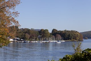
Candlewood Lake is a manmade lake located in Fairfield and Litchfield counties of Western Connecticut, in the northeastern United States. At 8.4 square miles (22 km2), it is the largest lake in Connecticut and the largest lake in the New York Metropolitan Area.The lake is bordered by the city of Danbury, and the towns of Brookfield, New Fairfield, New Milford, and Sherman. Some of the most expensive real estate in the Greater Danbury area is located along the shores of the lake.

<span class="mw-page-title-main">Schaghticoke people</span> Native American tribe of the Eastern Woodlands

The Schaghticoke are a Native American tribe of the Eastern Woodlands who historically consisted of Mahican, Potatuck, Weantinock, Tunxis, Podunk, and their descendants, peoples indigenous to what is now New York, Connecticut, and Massachusetts. The remnant tribes amalgamated in the area near the Connecticut-New York border after many losses, including the sale of some Schaghticoke and members of neighboring tribes into slavery in the Caribbean in the 1600s.

<span class="mw-page-title-main">Greater Danbury</span> Metropolitan area in Connecticut, United States

Greater Danbury, also known as the Housatonic Valley Region, is a region in the state of Connecticut centered on the city of Danbury. It consists of the city of Danbury and adjacent towns in the areas around the Housatonic River and the Still River. The area is also home to Candlewood Lake, the largest lake in the New York metropolitan area.

The History of Brookfield, Connecticut extends back roughly three centuries.

<span class="mw-page-title-main">Housatonic Range Trail</span>

The Housatonic Range Trail is a 6.2-mile (10.0 km) Blue-Blazed hiking trail on Candlewood Mountain in the town of New Milford. The north-south axis of the trail parallels the Housatonic River through private land and land trust parcels. The Housatonic Range Trail is maintained largely through the efforts of the Connecticut Forest and Park Association, which provides online Blue Trail maps.

Chief Squantz was a leader of the people of the Schaghticoke tribe who lived until 1724. Chief Squantz refused to sell the land that is now called the towns of Sherman, Connecticut, and New Fairfield, Connecticut, to a group of twelve colonists called "The Proprietors" who came from Fairfield to find land for a new colonial township.

Waramaug succeeded Squantz in 1725 as sachem of the Potatuck Native American tribe, folded into the current Schaghticoke tribe, who lived along the length of the Housatonic River, until his death in 1735. He was succeeded as sachemship of the Potatuck after his death by one of Chief Squantz's sons, Mauwehu.

<span class="mw-page-title-main">Candlewood Lake Club, Connecticut</span> Census-designated place in Connecticut, United States

Candlewood Lake Club is a private residential community and census-designated place (CDP) in the town of Brookfield, Fairfield County, and in the town of New Milford, Litchfield County, in the U.S. state of Connecticut. It is in the northwest corner of Brookfield and the southwest corner of New Milford, on the east shore of Candlewood Lake. It is bordered to the south by Candlewood Shores, to the north by Chimney Point, and to the west by the town of New Fairfield.

<span class="mw-page-title-main">Knollcrest, Connecticut</span> Census-designated place in Connecticut, United States

Knollcrest is a census-designated place (CDP) in the town of New Fairfield, Fairfield County, Connecticut, United States. It is in the northeast part of the town, on a peninsula on the western side of Candlewood Lake. It is bordered to the northeast, across Squantz Cove, by Bogus Hill.

<span class="mw-page-title-main">Inglenook, Connecticut</span> Census-designated place in Connecticut, United States

Inglenook is a census-designated place (CDP) in the town of New Fairfield, Fairfield County, Connecticut, United States. It is in the northeast part of the town, atop a broad peninsula in Candlewood Lake. It is bordered to the east by Sail Harbor and to the north by the town of Sherman.

<span class="mw-page-title-main">Sail Harbor, Connecticut</span> Census-designated place in Connecticut, United States

Sail Harbor is a census-designated place (CDP) in the towns of New Fairfield and Sherman, Fairfield County, Connecticut, United States. It is in the northeast corner of New Fairfield and the southeast corner of Sherman, on Great Neck and Shelter Harbor, landforms on the west side of Candlewood Lake. It is bordered to the west by Inglenook.

Lakeside Woods is a census-designated place (CDP) in the town of Sherman, Fairfield County, Connecticut, United States. It is in the southern part of the town, on the western shore of Candlewood Lake. It is bordered to the north by the main village of Sherman.

Sherman is a census-designated place (CDP) comprising the central community in the town of Sherman, Fairfield County, Connecticut, United States. It is in the central part of the town, at the north end of Candlewood Lake. The Sherman Historic District covers 85 acres (34 ha) in the northern part of the CDP, at the intersection of Connecticut Routes 37 and 39, containing many of the oldest buildings in the town.

<span class="mw-page-title-main">Squantz Pond</span> Lake in New Fairfield, Connecticut

Squantz Pond is a 288-acre lake in Fairfield County, Connecticut. It is located on the town line of Sherman and New Fairfield, and is bordered by manmade Candlewood Lake. The south shore is protected as Squantz Pond State Park, and is managed by the Connecticut Department of Energy and Environmental Protection. The pond is named for Chief Squantz, a leader of the Schaghticoke tribe.

References

  1. "Census - Geography Profile: Sherman town, Fairfield County, Connecticut". United States Census Bureau . Retrieved December 21, 2021.
  2. The Connecticut Magazine: An Illustrated Monthly. Connecticut Magazine Company. 1903. p. 334.
  3. Hodara, Susan (November 28, 2018). "Sherman, Conn.: A Quiet Town with a Medley of People". The New York Times.
  4. Simon, Irving B. (1975). Our Town: The History of New Fairfield. New Fairfield, Connecticut: New Fairfield Bicentennial Commission. p. 5.
  5. "Sherman Connecticut - Welcome to Sherman". Sherman Connecticut.
  6. "Sherman School". Sherman School.
  7. "Morrissey Brook, Connecticut". Geographic Names Information System . United States Geological Survey, United States Department of the Interior. December 31, 1981. Retrieved April 7, 2023. In Variant Names section.
  8. Naromi Land Trust, accessed August 11, 2006
  9. Web page for Public Act 01-194 at Connecticut General Assembly Web site, accessed August 11, 2001
  10. "History of the towns of New Milford and Bridgewater, Connecticut, 1703-1882". Hartford, Conn., Press of the Case, Lockwood and Brainard Co. 1882.
  11. Connecticut Department of Transportation, Division of Traffic Engineering (2021). "Sign Catalog: 50 Series – Guide & Informational Signs" (PDF). p. 49. Sign catalog number 51-2018.
  12. "Census of Population and Housing". Census.gov. Retrieved June 4, 2015.
  13. "U.S. Census website". United States Census Bureau . Retrieved January 31, 2008.
  14. "2010 Demographic Profile" . Retrieved March 22, 2013.[ failed verification ]
  15. "General Elections Statement of Vote 1922".