
Georgetown is a census-designated place in Fairfield County, Connecticut, United States. It is located in the area where the towns of Wilton, Redding, and Weston meet.

Westport is a town in Fairfield County, Connecticut, United States, along the Long Island Sound within Connecticut's Gold Coast. It is 52 miles (84 km) northeast of New York City. The town had a population of 26,391 according to the 2010 U.S. Census, and is ranked 19th among America's 100 Richest Places as well as third in Connecticut, with populations between 20,000 and 65,000.
Bethel is a census-designated place (CDP) in Fairfield County, Connecticut, United States. It comprises the primary village and surrounding residential land within the town of Bethel. As of the 2010 census, the population of the CDP was 9,549, out of 18,584 in the entire town.

Byram is a neighborhood/section and census-designated place (CDP) in the town of Greenwich in Fairfield County, Connecticut, United States. It had a population of 4,146 at the 2010 census, and a census-estimated population of 4,216 in 2018. An endcap of Connecticut's Gold Coast, Byram is the southernmost point in the town of Greenwich and the U.S. state of Connecticut. It is separated from Port Chester, Westchester County, New York, by the Byram River. Byram was once known as East Port Chester.

Glenville is a neighborhood and census-designated place in the town of Greenwich in Fairfield County, Connecticut, United States. As of the 2010 census, it had a population of 2,327. It is located in the western part of Greenwich at the falls of the Byram River, which provided waterpower when this was a mill village. The area is home to Glenville Elementary school, Western Civic Center and a volunteer fire station, the Glenville Fire Department.

Saugatuck is a census-designated place (CDP) in the town of Westport, Fairfield County, Connecticut, United States. It is in the southwest part of the town, on both sides of the Saugatuck River, extending south to where it enters Long Island Sound. North of Interstate 95, it occupies just the west side of the Saugatuck and continues north as far as U.S. Route 1. It is bordered to the north by Westport Village and to the west by the city of Norwalk. The CDP includes the communities of Owenoke and Saugatuck Shores, as well as the Metro-North Railroad Westport station.
Compo is a census-designated place (CDP) in the town of Westport, Fairfield County, Connecticut, United States. It is in the south-central part of the town, lying between the Saugatuck River and the neighborhood of Saugatuck to the west, and Compo Cove, Sherwood Millpond, and the neighborhood of Greens Farms to the east. The CDP extends south to Compo Beach on Long Island Sound and north to U.S. Route 1. Interstate 95 crosses the middle of the CDP from east to west, with access from either Saugatuck or Greens Farms.

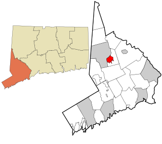
Wilton Center is a neighborhood/section and census-designated place (CDP) in the town of Wilton in Fairfield County, Connecticut, United States. As of the 2010 census it had a population of 732. The CDP partially overlaps the Wilton Center Historic District.

Pemberwick is a neighborhood/section and census-designated place in Greenwich in Fairfield County, Connecticut, United States. As of the 2010 census it had a population of 3,680.

Greenwich is a census-designated place (CDP) in Fairfield County, Connecticut, United States. It is one of several CDPs within the town of Greenwich and corresponds to the historic municipal center of the town and surrounding residential and commercial areas. As of the 2010 census, the population of the Greenwich CDP was 12,942, out of 61,171 in the entire town.
Noroton is a census-designated place (CDP) in the town of Darien, Fairfield County, Connecticut, United States. It occupies the southwest part of Darien, from the Metro-North Railroad in the north to Long Island Sound in the south. The southern half of the community occupies Noroton Neck, between Holly Pond to the west and the Goodwives River to the east. It is bordered to the west by the city of Stamford and to the east by the Tokeneke neighborhood of Darien. To the north is Noroton Heights.
Rock Ridge is a census-designated place (CDP) in the town of Greenwich, Fairfield County, Connecticut, United States. It is in the western part of the town, just 1 mile (2 km) east of the New York state border. Rock Ridge was first listed as a CDP prior to the 2020 census.
Indian Field is a census-designated place (CDP) in the town of Greenwich, Fairfield County, Connecticut, United States. It is in the southern part of the town, on a peninsula between Indian Harbor to the west and Cos Cob Harbor to the east. It extends south into Captain Harbor, an inlet of Long Island Sound, and it extends north as far as U.S. Route 1. Interstate 95 crosses the CDP, with access from Exit 4.
New Canaan is a census-designated place (CDP) in the town of New Canaan, Fairfield County, Connecticut, United States. It represents the built-up center of town around the intersections of Main Street, East Street, Elm Street, and South Avenue. It was first listed as a CDP prior to the 2020 census.
Darien Downtown is a census-designated place (CDP) in the town of Darien, Fairfield County, Connecticut, United States. It represents the built-up center of town around the intersections of U.S. Route 1, Connecticut Route 124, and Connecticut Route 136. Interstate 95 passes through the southern part of the CDP, with access from Exit 11 and Exit 12. It was first listed as a CDP prior to the 2020 census.
Tokeneke is a census-designated place (CDP) in the town of Darien, Fairfield County, Connecticut, United States. It comprises the southeast part of the town, occupying several peninsulas and islands that extend into Long Island Sound, between the Goodwives River to the west and the Fivemile River to the east. It is bordered to the north by Darien Downtown and to the east by the city of Norwalk.
Westport Village is a census-designated place (CDP) in the town of Westport, Fairfield County, Connecticut, United States. It comprises the town center of Westport.
Old Hill is a census-designated place (CDP) in the town of Westport, Fairfield County, Connecticut, United States. It is in the western part of the town and is bordered to the west by the city of Norwalk.
Poplar Plains is a census-designated place (CDP) in the town of Westport, Fairfield County, Connecticut, United States. It occupies the northwest corner of the town and is bordered to the southwest by the city of Norwalk, to the northwest by the town of Wilton, to the northeast by the town of Weston, to the east by the Saugatuck River, and to the south by the Merritt Parkway.
Staples is a census-designated place (CDP) in the town of Westport, Fairfield County, Connecticut, United States. It occupies the eastern side of the town and is bordered to the north by Cross Highway, to the west by Compo Road, to the south by U.S. Route 1, and to the east by the town of Fairfield.


