
Fairfield County is a county in the southwestern corner of the U.S. state of Connecticut, and its most populous and fastest-growing from 2010-2018. As of the 2010 census, the county's population was 916,829, estimated to have increased by 3.6% to 949,921 in 2017, and decreased to 943,332 in 2019. The most populous county in the state, the county population represents a little over 25% of Connecticut's overall population and is one of its fastest-growing counties. The closest to the center of the New York metropolitan area, the county contains four of the state's largest cities–Bridgeport (1st), Stamford (3rd), Norwalk (6th), and Danbury (7th)–whose combined population of 433,368 is nearly half the county's total population.

Danbury is a city in Fairfield County, Connecticut, United States, located approximately 50 miles (80 km) northeast of New York City, making it part of the New York metropolitan area. Danbury's population at the 2010 census was 80,893.

Wasaga Beach is a town in Simcoe County, Ontario, Canada. Situated along the longest freshwater beach in the world, it is a popular summer tourist destination. It is located along the southern end of Georgian Bay, approximately two hours north of Toronto. To the west, Collingwood and The Blue Mountains also attract visitors much of the year. The town is situated along a very long sandy beach on Nottawasaga Bay in Georgian Bay and the winding Nottawasaga River. The beaches are part of the Wasaga Beach Provincial Park; the park area totals 168 hectares. Wasaga Beach has a year round population of 20,675 as of 2016, but during the summer months the population increases with many seasonal residents.

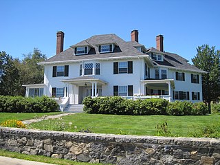
The Little White House was the personal retreat of Franklin D. Roosevelt, the 32nd President of the United States, located in the Historic District of Warm Springs, Georgia. He first came to Warm Springs in 1924 for polio treatment, and liked the area so much that, as Governor of New York, he had a home built on nearby Pine Mountain. The house was finished in 1932. Roosevelt kept the house after he became President, using it as a presidential retreat. He died there on April 12, 1945, three months into his fourth term.

0px|A typical thatched cottage in Yealmpton, Devon, England, built many centuries ago. Although it looks attractive, it was built as a purely functional building with no thought given to aesthetics]]
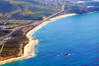
Crystal Cove State Park is a state park of California, United States, encompassing 3.2 miles (5.1 km) of Pacific coastline, inland chaparral canyons, and the Crystal Cove Historic District of beach houses. The park is located in Newport Beach. Crystal Cove is a stretch of coastal cliffs and a beachfront cove situated between the Pacific Coast Highway and the Pacific Ocean just north of Laguna Beach. The 3,936-acre (1,593 ha) park was established in 1979. The entire park hosts a total of 3 miles of beaches and tide pools, a 1,400 acre marine Conservation Area as well as underwater park, 400 acres of bluffs, and 2,400 acres of canyons.

Candlewood Lake is a manmade lake located in Fairfield and Litchfield counties of western Connecticut, in the northeastern United States. At 8.4 square miles (22 km2), it is the largest lake in Connecticut. The lake is bordered by five towns: Brookfield, Danbury, New Fairfield, New Milford, and Sherman. Some of the most expensive real estate in Connecticut is located on the shores of the lake, in the towns of Brookfield, New Fairfield, New Milford, and Sherman.

The Roman Catholic Diocese of Bridgeport is located in the southwestern part of the state of Connecticut, and its boundaries are the same as that of Fairfield County, Connecticut. There are 82 parishes in the diocese. Its cathedral is St. Augustine in Bridgeport.
New Dorp Beach is along the shore of the neighborhood of New Dorp, on Staten Island, one of the five boroughs of New York City. It is between Midland Beach and Oakwood Beach.

Arverne is a neighborhood in the New York City borough of Queens, on the Rockaway Peninsula. It was initially developed by Remington Vernam, whose signature "R. Vernam" inspired the name of the neighborhood. Arverne extends from Beach 56th Street to Beach 79th Street, along its main thoroughfare Beach Channel Drive, alternatively known as Rev. Joseph H. May Drive.

The history of Virginia Beach, Virginia, goes back to the Native Americans who lived in the area for thousands of years before the English colonists landed at Cape Henry in April 1607 and established their first permanent settlement at Jamestown a few weeks later. The Colonial Virginia period extended until 1776 and the American Revolution, and the area has been part of the Commonwealth of Virginia ever since.
Sherwood Island State Park is a public recreation area on the shore of Long Island Sound in the Greens Farms section of Westport, Connecticut. The state park offers swimming, fishing, and other activities on 238 acres (96 ha) of beach, wetlands, and woodlands. Sherwood Island is numbered as Connecticut's first state park because state purchase of land at the site began in 1914. The park is managed by the Connecticut Department of Energy and Environmental Protection.

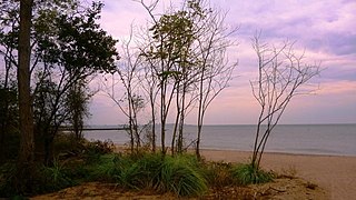
White Horse Beach is a village of Plymouth, Massachusetts, United States. It is located on Cape Cod Bay, south of Priscilla Beach. Much of the southern end of the beach, which is also known as Taylor Avenue Beach, south of the outflow of Bartlett Pond, either has cottages on it or has a fenced off conservation area to protect the dunes and fragile plant life.

The Main Street Historic District in Danbury, Connecticut, United States, is the oldest section of that city, at its geographical center. It has long been the city's commercial core and downtown. Its 132 buildings, 97 of which are considered contributing properties, include government buildings, churches, commercial establishments and residences, all in a variety of architectural styles from the late 18th century to the early 20th. It is the only major industrial downtown of its size in Connecticut not to have developed around either port facilities or a water power site.

Victoria Beach is a rural municipality located on the southeastern shores of Lake Winnipeg. It is approximately 100 kilometres (62 mi) north of Winnipeg, the provincial capital of Manitoba, Canada. Its land area is 20.279 km², making it the smallest rural municipality in Manitoba. It is slightly less than half the size of the next-smallest Rural Municipality of East St. Paul. It lies on a small peninsula that extends into Lake Winnipeg, and is almost completely surrounded by the lake, but does share a small southern land border with the Rural Municipality of Alexander. Elk Island Provincial Park lies on an island in the north end of the municipality.

The Mamakating Park Historic District is located on the ridge north of Masten Lake on the highest ground in the Town of Mamakating, New York, United States. It is a Catskill vacation community, originally intended to be the much larger Sullivan County Club, built in the 1890s.

Bridgeport is a historic seaport city in the U.S. state of Connecticut, and its largest city. With a census-estimated population of 144,399 in 2019, it is also the fifth-most populous in New England. Located in Fairfield County at the mouth of the Pequonnock River on Long Island Sound, it is 60 miles (97 km) from Manhattan and 40 miles (64 km) from The Bronx. It is bordered by the towns of Trumbull to the north, Fairfield to the west, and Stratford to the east. Bridgeport and other settlements in Fairfield County make up the Bridgeport-Stamford-Norwalk-Danbury metropolitan statistical area, the second largest metropolitan area in Connecticut. The Bridgeport-Stamford-Norwalk-Danbury metropolis forms part of the New York megacity.
The Little Boar's Head Historic District encompasses an area of summer resort and beachfront properties in North Hampton, New Hampshire. Located on New Hampshire's seacoast roughly between North Hampton State Beach and Bass Beach, the district is almost entirely residential, consisting mainly of houses built as summer vacation spots in the late 19th and early 20th centuries, with associated beachfront amenities. The district was listed on the National Register of Historic Places in 1999.

The Charnley-Norwood House is a summer (winter) cottage designed by architects Louis Sullivan and Frank Lloyd Wright in 1890 in Ocean Springs, Mississippi on the Mississippi Gulf Coast. The home was built as a vacation residence for James Charnley, a wealthy Chicago lumber baron, and its style represents an important change in American residential architecture known as Prairie School.

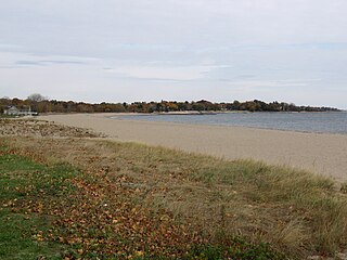
Sag Harbor Hills, Azurest, and Ninevah Beach Subdivisions Historic District (SANS) is an African American beachfront community in Sag Harbor, New York. Founded following World War II, the SANS community served primarily as a summer retreat for middle-class African American families during the post-WWII and Jim Crow era. African American families were not allowed at beachfront resorts, pools or beaches, and SANS began as a place of refuge from racial strife. The historic district is bordered by Hempstead Street, Richards Drive, Hampton Street, Lincoln Street, Harding Terrace, Terry Drive and the eastern end of Haven's Beach in Sag Harbor. It was placed on the National Register of Historic Places on July 10, 2019.


