West Haven, Connecticut

Last updated

West Haven, Connecticut
City of West Haven
West Haven City Hall 109.JPG
West Haven City Hall
Seal-westhaven.png
Motto(s): 
Nil Desperandum
(Latin: Do Not Despair)
New Haven County Connecticut Incorporated and Unincorporated areas West Haven Highlighted.svg
West Haven, Connecticut
Coordinates: 41°16′26″N72°58′04″W / 41.27389°N 72.96778°W / 41.27389; -72.96778
CountryFlag of the United States (23px).png  United States
U.S. state Flag of Connecticut.svg  Connecticut
County New Haven
Region South Central CT
Incorporated (town)1921
Incorporated (city)1961
Government
  Type Mayor-council
  Mayor Dorinda Borer [1]
Area
[2]
  Total10.92 sq mi (28.27 km2)
  Land10.75 sq mi (27.84 km2)
  Water0.17 sq mi (0.43 km2)
Elevation
33 ft (10 m)
Population
 (2020)
  Total55,584
  Density5,171/sq mi (1,996.6/km2)
Demonym Westie [3] [4] [5]
Time zone UTC−5 (Eastern)
  Summer (DST) UTC−4 (Eastern)
ZIP code
06516
Area code(s) 203/475
FIPS code 09-82800
GNIS feature ID0211953
Major highways I-95.svg US 1.svg
Commuter Rail MTA NYC logo.svg
Website www.cityofwesthaven.com

West Haven is a city in New Haven County, Connecticut, United States, located on the coast of Long Island Sound. The city is part of the South Central Connecticut Planning Region. At the 2020 census, the population of the city was 55,584. [6]

Contents

History

West Haven historical marker West Haven town historical sign.jpg
West Haven historical marker

Settled in 1648, West Haven (then known as West Farms) was a part of the original New Haven Colony. In 1719, it became the separate parish of West Haven, but was still officially a part of New Haven until 1822.

During the American Revolution, West Haven was the frequent launch and arrival point for raiding parties on both sides of the war. On July 5, 1779, the British invaded New Haven Harbor and came ashore in West Haven and East Haven. Thomas Painter, a teenaged militiaman watching for the approaching British ships while standing atop Savin Rock, is depicted on the city seal. The main commercial street, Campbell Avenue, is named for British Adjutant William Campbell, at the time an ensign in the Third Guards, who rescued the Reverend Noah Williston, the local Congregational minister and outspoken revolutionary, from being bayoneted by British and Hessian troopers, after he broke his leg trying to escape his captors. Campbell then ordered the soldiers to help the minister back to the parsonage and had the regimental surgeon set his leg. Campbell is also credited with keeping the troops in reasonably good order during their march through the village and reportedly had two soldiers arrested after a local woman accused them of stealing her jewelry. Campbell was killed hours later atop Allingtown Hill on his way to New Haven by a local farmer-turned defender. Campbell is buried in the Allingtown section of town off Prudden Street. Patriot victims of the invasion are buried in the Christ Church and First Society Cemetery. A historical headstone marks Campbell's approximate gravesite and is maintained by the West Haven Historical Society.

While West Haven again attempted to incorporate as its own town in 1784, that attempt failed, primarily due to the protests of neighboring Milford, which opposed North Milford becoming part of the new town. West Haven and North Milford tried again in 1786 and 1787 with the same result. The two finally joined to become Orange (incorporated as a town in 1822). In 1921, West Haven split from Orange to become a separate town. It was incorporated as a city in 1961 and is known as "Connecticut's Youngest City", [7] although it is also one of the state's oldest settlements.

The Savin Rock section of West Haven was the site of the Savin Rock Amusement Park, which began in the late 19th century as a regionally renowned seaside resort. It evolved into a general amusement park in the 20th century and eventually closed in the 1960s. The park ran along the west side of the New Haven Harbor beachfront.

What followed was a 40 year struggle to stop Savin Rock's Redevelopment—approved by voters in 1963 and officially starting in 1966. It involved multiple referendums, petition drives, court cases, and Connecticut Supreme Court decisions affecting the 40 acre area. Opposition began about 1971 soon after old Savin Rock had been torn down and the first project built, but ballooned in 1973 when Save Our Shore (SOS) led a referendum to stop "the Great Wall of China", an 800 foot 12 story apartment, proposed for a 10 acre parcel, blocking the shore view. A 1974 referendum to stop all development was organized by IMPACT (successor to SOS), but was overturned by the Supreme Court in 1978. This led to a struggle for a Compromise Plan, initiated by Mayor Robert Johnson, and brought to completion by action of the Concerned Citizens for Bradley Point (1979), which petitioned the final holdout to the Plan, to which the Supreme Court had required all developers to agree for any significant change. The Compromise was signed by all in May 1979, but IMPACT continued to oppose it thru 1980. Thereafter, a committee sought public input and federal money, and in July 1984, the 20 acre Bradley Point Veterans Memorial Park opened. In 1987 and 1989, the city bought development rights of all the remaining parcels, part of which became the Old Grove Park and part included a former restaurant that became the Savin Rock Conference Center. In 1991, the Land Trust of West Haven, Inc. was founded, but it was not until 2007 that a Conservation Easement was signed, preserving all but the Conference Center, as open space forever—beautiful parks, with walks and bike path, along Connecticut's longest public shoreline. [8] Several restaurants remain as last reminders of the area's commercial past.

West Haven has a mayor-council form of government. Nancy R. Rossi, [9] the city's twelfth mayor, was elected in 2017. She is West Haven's first female mayor. There are two independent fire districts served by the First Fire Taxation (Center) and West Shore. The Allingtown Fire District was relatively recently subsumed by the City who's now responsible for all of its pension-related obligations going forward. Residents expect efforts will be made to consolidate the remaining two fire districts based, in large part, on the recommendation of the State's Municipal Accountability Review Board (MARB) who is currently providing financial support and guidance to the City. As it currently stands, each of the remaining independent Fire Districts levy its own tax rate.

In 1986, West Haven observed the Bicentennial of the United States Constitution. During the year-long celebrations, the mayor and council passed numerous resolutions to encourage community involvement, including naming the official ship of West Haven—the U.S. Navy destroyer USS Edson (DD-946)—and the city's official flower, the daylily. Public schools included curriculum on the Constitution from K–12, and school children were released from class to participate in a Constitution Day parade up Campbell Avenue.[ citation needed ]

In June 2014, the "Where Angels Play" playground opened next to Sea Bluff Beach in West Haven. The playground was built in honor of Charlotte Bacon, a victim of the Sandy Hook Elementary School shooting. [10] The playground is pink for Charlotte's favorite color and includes some of her drawings. [11]

On the National Register of Historic Places

Corner of Main St and Campbell Ave West Haven Main and Campbell 110.JPG
Corner of Main St and Campbell Ave
Ocean Ave Aerial with Bradley Point in view, taken near South Street Ocean Ave Aerial-1.jpg
Ocean Ave Aerial with Bradley Point in view, taken near South Street

Geography

According to the U.S. Census Bureau, the city has a total area of 11 square miles (28 km2), of which 10.75 square miles (27.8 km2) is land .2 square miles (0.52 km2), or 1.54%, is water. West Haven has 3.5 miles (5.6 km) of publicly accessible beaches, which is one-quarter of the publicly accessible beaches in Connecticut. The hilly Allingtown district of the city is home to the University of New Haven.

West Haven is located in the south-central portion of Connecticut's 3rd congressional district. The city is bound on the southwest by the Oyster River (the boundary between West Haven and Milford since colonial times), northwest by Orange, north by New Haven and northeast by the West River, which divides West Haven and New Haven. To the east is New Haven Harbor and to the south is Long Island Sound. The Cove River flows through the city.

Principal communities

The three significant neighborhoods in West Haven correspond to the three fire districts. As communities, not all sections of the city fit neatly into these divisions.

Additional Neighborhoods:

Demographics

Historical population
CensusPop.Note
1930 25,808
1940 30,02116.3%
1950 32,0106.6%
1960 43,00234.3%
1970 52,85122.9%
1980 53,1840.6%
1990 54,0211.6%
2000 52,360−3.1%
2010 55,5646.1%
2020 55,5840.0%
U.S. Decennial Census [13]

As of the census [14] [15] of 2010, there were 55,564 people, 19,886 households. The population density was 5,170.2 inhabitants per square mile (1,996.2/km2). There were 22,336 housing units at an average density of 2,061.3 per square mile (795.9/km2). The racial makeup of the city was 63.3% white, 20.6% African American, 0.3% Native American, 4.2% Asian American, 0.0% Pacific Islander, 3.57% from other races and 4.8% from two or more races. 23.2% of the population were Hispanic or Latino of any race.

There were 21,090 households, out of which 28.5% had children under the age of 18 living with them, 41.9% were married couples living together, 15.6% had a female householder with no husband present, and 37.8% were non-families. 31.0% of all households were made up of individuals, and 10.7% had someone living alone who was 65 years of age or older. The average household size was 2.42 and the average family size was 3.06.

In the city, the population was spread out, with 19.7% under the age of 18, 9.7% from 18 to 24, 31.2% from 25 to 44, 21.8% from 45 to 64, and 14.2% who were 65 years of age or older. The median age was 36 years. For every 100 females, there were 91.3 males. For every 100 females age 18 and over, there were 88.2 males.

The median income for a household in the city from 2015-2019 was $62,985 in 2019 dollars. Males had a median income of $38,024 versus $30,610 for females. The per capita income for the city was $21,121. About 6.6% of families and 8.8% of the population were below the poverty line, including 11.8% of those under age 18 and 6.0% of those age 65 or over.

Business

West Haven was a shipping and industrial center, known for its buckle shops and later Armstrong Rubber Co. Coleco (originally Connecticut Leather Company- later the toy & video game manufacturer), and Sikorsky Aircraft, a division of United Technologies, also had operations in West Haven.

Bayer Pharmaceuticals North America, a branch of Bayer AG, based in Leverkusen, North Rhine-Westphalia, Germany, had a plant in West Haven, but the company announced in 2006 that it was shutting its operations in the city, affecting about 1,000 workers. The 137-acre (0.55 km2) former Bayer campus comprises 17 buildings, mostly in West Haven but partly in Orange. In 2007, Yale University purchased the entire campus for biotechnology, pharmaceutical and other life sciences research. [16]

Education

West Haven Board of Education is the local school district.

West Haven is home to the University of New Haven, a U.S. Veterans Affairs hospital, and Yale Field, a baseball park for the Yale University teams and formerly the home field for minor league baseball teams.

The Yale University athletic fields extend into West Haven. [17] The Yale Bowl, the home field of the Yale Bulldogs, is in New Haven, near the West Haven border.

Transportation

West Haven station West Haven from Hood Terrace May 2013 1.JPG
West Haven station

Interstate 95, Connecticut State Route 34 (also known as Derby Avenue), and U.S. Route 1 (the Boston Post Road) run through West Haven, between Orange and New Haven. Route 162, which both begins and ends at Route 1, starts in Orange, passes through West Haven, and ends in Milford. A north-south state road, Route 122, begins in New Haven, comprising Forest Road, a stretch of Campbell Avenue and First Avenue up to the junction with I-95.

Bus service is provided by Connecticut Transit New Haven. West Haven Center is served by the various 265 and 271 routes (main service along Campbell Avenue). The 265B service continues to Saw Mill Road and Bull Hill Lane; the 265R service run along Jones Hill Road and terminate at the Baybrook Shopping Center near Oyster River; the 265S service continues to Savin Rock via Second Avenue. The Route 271M/S routes run along the West Haven shore towards Milford. The Route 261 route serves the areas along Orange Avenue. The 268 route serves the Veterans Affairs Hospital (C) and Bull Hill Lane (B).

A rail line, used by Metro-North Railroad and Amtrak, runs through West Haven. In 2013, the Connecticut Department of Transportation opened a new Metro-North station in West Haven, across from the former Armstrong factory. [18] West Haven station provides commuter rail service on the Metro-North Railroad's New Haven Line. The station provides full service on Metro-North into New York City, and has 660 parking spaces on-site. Amtrak does not stop in West Haven; the closest Amtrak stop is New Haven's Union Station.

Tweed New Haven Regional Airport, in New Haven, is the closest facility offering air service to West Haven.

Notable people

See also

Related Research Articles

<span class="mw-page-title-main">New Haven, Connecticut</span> City in Connecticut, United States

New Haven is a city in New Haven County, Connecticut, United States. It is located on New Haven Harbor on the northern shore of Long Island Sound and is part of the New York City metropolitan area. With a population of 135,081 as determined by the 2020 U.S. census, New Haven is the third largest city in Connecticut after Bridgeport and Stamford, the largest city in the South Central Connecticut Planning Region, and the principal municipality of Greater New Haven, which had a total population of 864,835 in 2020. Prior to 1960, it was the county seat of New Haven County until the county governments were abolished that year.

<span class="mw-page-title-main">Fairfield County, Connecticut</span> County in Connecticut, United States

Fairfield County is a county in the southwestern corner of the U.S. state of Connecticut. It is the most populous county in the state and was also its fastest-growing from 2010 to 2020. As of the 2020 census, the county's population was 957,419, representing 26.6% of Connecticut's overall population. The closest to the center of the New York metropolitan area, the county contains four of the state's top 7 largest cities—Bridgeport (1st), Stamford (2nd), Norwalk (6th), and Danbury (7th)—whose combined population of 433,368 is nearly half the county's total population.

<span class="mw-page-title-main">New Haven County, Connecticut</span> County in Connecticut, United States

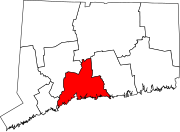
New Haven County is a county in the south central part of the U.S. state of Connecticut. As of the 2020 census, the population was 864,835, making it the third-most populous county in Connecticut. Two of the state's top 5 largest cities, New Haven (3rd) and Waterbury (5th), are part of New Haven County.

<span class="mw-page-title-main">Branford, Connecticut</span> Town in Connecticut, United States

Branford is a shoreline town located on Long Island Sound in New Haven County, Connecticut, United States, about 6 miles (10 km) east of downtown New Haven. The town is part of the South Central Connecticut Planning Region. Branford borders East Haven to the west, Guilford to the east, and North Branford to the north. The population was 28,273 in the 2020 census.

<span class="mw-page-title-main">Guilford, Connecticut</span> Town in Connecticut, United States

Guilford is a town in New Haven County, Connecticut, United States, that borders Madison, Branford, North Branford and Durham, and is situated on I-95 and the Connecticut coast. The town is part of the South Central Connecticut Planning Region. The population was 22,073 at the 2020 census.

<span class="mw-page-title-main">Hamden, Connecticut</span> Town in Connecticut, United States

Hamden is a town in New Haven County, Connecticut, United States. The town's nickname is "The Land of the Sleeping Giant". The town is part of the South Central Connecticut Planning Region. The population was 61,169 at the 2020 census.

<span class="mw-page-title-main">Milford, Connecticut</span> City in Connecticut, United States

Milford is a coastal city in New Haven County, Connecticut, United States, between New Haven and Bridgeport. The population was 50,558 at the 2020 United States Census. The city includes the village of Devon and the borough of Woodmont. Milford is part of the South Central Connecticut Planning Region and New York metropolitan area.

<span class="mw-page-title-main">Derby, Connecticut</span> City in Connecticut, United States

Derby is a city in New Haven County, Connecticut, United States, approximately 8 miles (13 km) west-northwest of New Haven. It is located in southwest Connecticut at the confluence of the Housatonic and Naugatuck rivers. It shares borders with the cities of Ansonia to the north and Shelton to the southwest, and the towns of Orange to the south, Seymour to the northwest, and Woodbridge to the east. The city is part of the Naugatuck Valley Planning Region. The population was 12,325 at the 2020 census. It is the smallest city in Connecticut by area, at 5.3 square miles (14 km2).

<span class="mw-page-title-main">East Haven, Connecticut</span> Town in Connecticut, United States

East Haven is a town in New Haven County, Connecticut, in the United States. As of the 2020 census, the town population was 27,923. The town is located 3 miles (5 km) east of New Haven, and is part of the South Central Connecticut Planning Region. East Haven is 35 miles (56 km) from Hartford, 82 miles (132 km) from New York City, 99 miles (159 km) from Providence, Rhode Island, and 140 miles (230 km) from Boston.

<span class="mw-page-title-main">Orange, Connecticut</span> Town in Connecticut, United States

Orange is a town in New Haven County, Connecticut, United States. The town is part of the South Central Connecticut Planning Region. The population was 14,280 at the 2020 census. The town is governed by a Board of Selectmen.

<span class="mw-page-title-main">Southold, New York</span> Town in New York, United States

The Town of Southold is one of ten towns in Suffolk County, New York, United States. It is located in the northeastern tip of the county, on the North Fork of Long Island. The population was 23,732 at the 2020 census. The town also contains a hamlet named Southold, which was settled in 1640.

Greater New Haven is the metropolitan area whose extent includes those towns in the U.S. state of Connecticut that share an economic, social, political, and historical focus on the city of New Haven. It occupies the south-central portion of the state, in a radius around New Haven.

<span class="mw-page-title-main">New Milford, Connecticut</span> Town in Connecticut, United States

New Milford is a town in Litchfield County, Connecticut, United States. The town, part of Greater Danbury, as well as the New York Metropolitan Area, has a population of 28,115 as of the 2020 census. New Milford lies 14 miles (23 km) north of Danbury on the banks of the Housatonic River, and shares its border with the northeastern shore of Candlewood Lake. It is the largest town in the state of Connecticut in terms of land area at nearly 63.7 mi2 (164.9822 km2). The town center is listed as a census-designated place (CDP).

<span class="mw-page-title-main">Connecticut Route 15</span> State highway in Connecticut, US

Route 15 is a state highway in the U.S. state of Connecticut that runs 83.53 miles (134.43 km) from a connection with New York's Hutchinson River Parkway in Greenwich, Connecticut, to its northern terminus intersecting with Interstate 84 (I-84) in East Hartford, Connecticut. Route 15 consists of four distinct sections: the Merritt Parkway, the Wilbur Cross Parkway, most of the Berlin Turnpike, and part of the Wilbur Cross Highway. The unified designation was applied to these separate highways in 1948 to provide a continuous through route from New York to Massachusetts. The parkway section of Route 15 is often referred to locally as "The Merritt".

<span class="mw-page-title-main">History of West Haven, Connecticut</span> Overview of the history of West Haven, Connecticut

This article covers the colonial and revolutionary history, the economic history, Savin Rock Park, and the 20th century history of West Haven, Connecticut.

<span class="mw-page-title-main">Whitneyville, Connecticut</span> Neighborhood in New Haven, Connecticut, United States

Whitneyville is a neighborhood in the southeastern portion of the town of Hamden, Connecticut. It started in the early nineteenth century as a factory town for workers in Eli Whitney's gun factory. Around the turn of the twentieth century, it evolved into a trolley suburb of New Haven. Today it is primarily residential, with a mixture of single-family homes and small apartment and condominium buildings. There is some commercial development centered around the intersection of Whitney and Putnam avenues.

<span class="mw-page-title-main">West Haven Green Historic District</span> Historic district in Connecticut, United States

West Haven Green is the town green of the New England town of West Haven, Connecticut. The green is bordered by Church Street on the south, Savin Avenue on the west, Main Street on the north and Campbell Avenue on the east. The green and surrounding buildings are part of the West Haven Green Historic District.

The city of New Haven, Connecticut has many distinct neighborhoods. In addition to Downtown, centered on the central business district and the Green, are the following neighborhoods: the west central neighborhoods of Dixwell and Dwight; the southern neighborhoods of The Hill, historic water-front City Point, and the harborside district of Long Wharf; the western neighborhoods of Edgewood, West River, Westville, Amity, and West Rock; East Rock, Cedar Hill, Prospect Hill, and Newhallville in the northern side of town; the east central neighborhoods of Mill River and Wooster Square, an Italian-American neighborhood; Fair Haven, an immigrant community located between the Mill and Quinnipiac rivers; Quinnipiac Meadows and Fair Haven Heights across the Quinnipiac River; and facing the eastern side of the harbor, The Annex and East Shore.

<span class="mw-page-title-main">Savin Rock Amusement Park</span>

Savin Rock was an American amusement park in West Haven, Connecticut. It was previously called The White City and was established in the 1870s. The park included a number of roller coasters, other rides and numerous funhouses.

<span class="mw-page-title-main">Richard Borer</span>

H. Richard Borer is a former American politician and current nonprofit executive. He was mayor of West Haven, Connecticut 1991–2005. Early on in his tenure as mayor, Borer inherited a financial crisis in the city that ultimately resulted in the State of Connecticut taking direct control over the local budget. As part of his turn around efforts, Borer reduced the size of the city's payroll by instituting layoffs in the Public Works Department. He was also the force behind forcing West Haven's long time political boss, Harold Allen from his position of power.

References

  1. "Mayor's Office". West Haven City Hall. Government Websites by CivicPlus. Retrieved July 19, 2017.
  2. "2019 U.S. Gazetteer Files". United States Census Bureau. Retrieved July 2, 2020.
  3. "West Havener is Irishman of the Year". New Haven Register. Digital First Media. March 9, 2012. Retrieved July 22, 2017.
  4. "Lifelong West Haven resident first woman to become police chief at University of New Haven". New Haven Register. Digital First Media. June 2016. Retrieved July 22, 2017.
  5. "FREDERICK CHARLES SPREYER JR". West Haven Funeral Home. Legacy.com. Retrieved July 22, 2017.
  6. "Census - Geography Profile: West Haven city, Connecticut". United States Census Bureau . Retrieved December 22, 2021.
  7. "West Haven, CT - Official Website". www.cityofwesthaven.com.
  8. "Savin Rock's Transition" by Stephen Hildrich ,Dan Shine, et al., 5 part series, Historian's Corner, https://westhavenvoice.com , January 11 – February 15, 2018
  9. "Mayor's Office". West Haven City Hall. West Haven, Connecticut. Retrieved July 20, 2017.
  10. "Charlotte Bacon's playground in West Haven to be built Friday, dedicated Sunday". New Haven Register. June 11, 2014. Retrieved January 18, 2019.
  11. Giammerino, Thea Di (June 16, 2014). "Playground in Honor of Charlotte Bacon Opens". NBC Connecticut. Retrieved January 18, 2019.
  12. "CONNECTICUT - New Haven County". National Register of Historic Places. American Dreams Inc. Retrieved July 21, 2017.
  13. "Census of Population and Housing". Census.gov. Retrieved June 4, 2015.
  14. "U.S. Census website". United States Census Bureau . Retrieved January 31, 2008.
  15. "U.S. Census website" . Retrieved January 31, 2008.
  16. "Yale buys West Haven's Bayer campus" by Cara Baruzzi, New Haven Register , June 14, 2007.
  17. "2020 CENSUS - CENSUS BLOCK MAP: West Haven city, CT" (PDF). U.S. Census Bureau. p. 1 (PDF p. 2/3). Retrieved July 1, 2023.
  18. "Our New West Haven Station Is Open For Business!" . Retrieved August 23, 2013.
  19. Web page titled "Miss America - Winter 2003 Newsletter" quotes from an Associated Press story (or, more likely, a picture caption), dated September 14, 1933: "Miss Marian Bergeron, 16-year-old West Haven, Connecticut, girl who won the "Miss America" title in the annual beauty pageant at Atlantic City, New Jersey," accessed March 13, 2007
  20. Salzo, Vincent (July 25, 2018). "West Haven Native, Writer-Director Jon Schnepp Dies At 51". Patch. Retrieved January 27, 2021.
  21. "Medal of Honor recipients - World War II (M-S)". Medal of Honor citations. United States Army Center of Military History. June 8, 2009. Retrieved November 1, 2007.
  22. "Congressional Medal of Honor". thistlegroup.net.
  23. Garber, Greg. "NO. 16: KEN STRONG - A football Giant and more". The Dallas Morning News / Associated Press Sports Edition. Retrieved June 2, 2006.