Litchfield Hills

Last updated
Map of Connecticut showing the Northwest Connecticut region in green and the Litchfield Hills region in blue Litchfieldhills.png
Map of Connecticut showing the Northwest Connecticut region in green and the Litchfield Hills region in blue

The Litchfield Hills (also known as the Northwest Hills or Northwest Highlands) are a geographic region of the U.S. state of Connecticut located in the northwestern corner of the state. It is roughly coterminous with the boundaries of Litchfield County, for which it is named. The geographic region includes colloquial subregions—rural Northwestern Connecticut and the area associated with the city of Torrington, also known as the Upper Naugatuck River Valley or simply Litchfield Hills—which have also variously corresponded to designated government councils both past and present. Much of the area makes up the lowermost section of the Berkshires and is culturally similar to the rest of western New England.

Contents

Towns and cities

Characteristics

The Litchfield hills are known for their distinct rural scenery, which can stand in contrast to central and southern Connecticut, which is largely urbanized or suburbanized. (However, there is some encroachment of development into the region as people from greater Hartford move west and people from New York City, northern New Jersey, and parts of Fairfield County move north.) This region is a key part of the Housatonic River and Farmington River watersheds, and encompasses a number of Connecticut's highest peaks, such as Bear Mountain and Canaan Mountain. Most of the region comprises forested and rocky hills with farmland and small towns interspersed in the flatter areas. The terrain in the Litchfield Hills area varies from gently rolling to the south and east to more mountainous toward the north and west. The region generally experiences colder temperatures due to higher elevation. [1] The Litchfield Hills, like the rest of Northwest Connecticut, are known for their town greens, fall foliage, and historical architecture. The hills comprise the southernmost portion of the Berkshires. This region also plays host to a large portion of the state's small vineyard and wine industry. Historically, the region was well known for the limestone, iron, and dairy industries.

A unique term to the region is the word "raggie". Used as an insult by some and with a sense of local pride by others, the term "raggie" denotes someone with a lower income and approximates the term "white trash". The term probably originated from iron workers from Mount Riga in Salisbury. These workers were often poor immigrants who wore grubby clothes as a result of their work. After the iron works closed down, the workers moved to Norfolk, Winsted, and Torrington, and the name stuck. The term "raggie" is rarely, if ever, heard elsewhere. [2]

Subregions

Northwestern Connecticut

A scene from The Hotchkiss School in Salisbury Litchfields.jpg
A scene from The Hotchkiss School in Salisbury

The towns included in the Northwestern Connecticut region are: Canaan, Cornwall, Kent, North Canaan, Roxbury, Salisbury, Sharon, Warren, Washington. Unlike the rest of Connecticut, the portion of Northwestern Connecticut around the upper Housatonic River contains more alkaline soils due to the underlying limestone. The flatter regions around the Housatonic River provide some of the best soils for farming in Litchfield County.

Due to the rural feel of the area, the region is an extremely popular location for second homes, primarily with New York City residents. The hills are rural enough to offer an escape from city life, yet close enough (less than 90 miles) to visit on weekends. Many visitors also arrive in the autumn to witness the fall foliage, and to visit the region's covered bridges or its many waterfalls.

The area has been and continues to be home to many famous or wealthy residents, including Mia Farrow, Meryl Streep, Dustin Hoffman, Denis Leary, Kevin Bacon, and is sometimes referred to as the Hamptons of Connecticut.[ citation needed ] This region is very similar to portions of Berkshire County, Massachusetts, which lies just to the north.

Northwestern Connecticut is known for its cultural activities, such as chamber performances at Music Mountain in Canaan and a wide array of art galleries. The region is also home to preparatory schools, such as the Hotchkiss School, Kent School, Marvelwood School, and The Gunnery.

Litchfield Hills

The Litchfield Hills region is also known as the Upper Naugatuck Valley and consists of the towns of Barkhamsted, Bethlehem, Colebrook, Goshen, Hartland, Harwinton, Litchfield, Morris, New Hartford, Norfolk, Torrington, and Winchester. The Litchfield Hills feel a stronger pull toward industry than Northwestern Connecticut, with manufacturing centering on the Naugatuck River in Torrington and Mad River in Winsted. Historically, brass, needles, scythes, and other products were manufactured in the area. However, the rural areas still retain industries such as dairy, vineyards, and stone. This region is sometimes included with the Naugatuck River Valley.

Originally settled in the mid 18th century as agriculturally based towns, the areas with access to flowing water began to develop industries in the 19th century. As the Midwest opened up to settlement, many farmers headed west in search of better farming opportunities. Among these included the John Brown family, originally from Torrington. Some notable areas settled by people from the Litchfield Hills include the Western Reserve of Ohio and Torrington, Wyoming. Around the time industry became important in the area, many immigrants came to work in the factories. Many of the immigrants in the Litchfield Hills area came from Italy, Ireland, Lebanon, Poland, and Slovakia. Later in the 20th century, many of these industries declined or relocated, producing conditions similar to the Midwestern rust belt, but on a smaller scale. Today, tourism remains an important industry for the Litchfield Hills.

The eastern towns, including Hartland, Barkhamsted, and New Hartford contain large water supply reservoirs to the city of Hartford.

Culturally, the Litchfield Hills are politically more conservative than the rest of Connecticut, with Litchfield County being the only county in the state to vote for George W. Bush in the 2004 election. The region contains its own section in the Waterbury Republican-American , which covers local events and news. The region is also split between allegiance to the New York Yankees and Boston Red Sox, with the southwestern part of the region generally supporting the Yankees and northeastern part of the region generally supporting the Red Sox.

Notable people

See also

Related Research Articles

<span class="mw-page-title-main">Litchfield County, Connecticut</span> County in Connecticut, United States

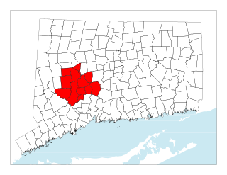
Litchfield County is in northwestern Connecticut, United States. As of the 2020 census, the population was 185,186. The county was named after Lichfield, in England. Litchfield County has the lowest population density of any county in Connecticut and is the state's largest county by area.

<span class="mw-page-title-main">Barkhamsted, Connecticut</span> Town in Connecticut, United States

Barkhamsted is a town in Litchfield County, Connecticut, United States. It contains seven villages: West Hill, Mallory, Barkhamsted Center, Center Hill, Washington Hill, Pleasant Valley, and Riverton. The population was 3,647 at the 2020 census, down from 3,799 at the 2010 census. The town is part of the Northwest Hills Planning Region. Barkhamsted was first incorporated in 1779, and named after Berkhamsted, Hertfordshire, England.

<span class="mw-page-title-main">Harwinton, Connecticut</span> Town in Connecticut, United States

Harwinton is a town in Litchfield County, Connecticut, United States. The population was 5,484 at the 2020 census. The town is part of the Northwest Hills Planning Region. The high school is Lewis S. Mills.

<span class="mw-page-title-main">New Hartford, Connecticut</span> Town in Connecticut, United States

New Hartford is a town in Litchfield County, Connecticut, United States. The population was 6,658 at the 2020 census. The town is part of the Northwest Hills Planning Region. The town center is defined by the U.S. Census Bureau as the New Hartford Center census-designated place (CDP). The town is mainly a rural community consisting of farms, homes, and parks. Brodie Park and Ski Sundown are located in New Hartford.

<span class="mw-page-title-main">Northwest Harwinton, Connecticut</span> Census-designated place in Connecticut, United States

Northwest Harwinton is a census-designated place (CDP) in the town of Harwinton in Litchfield County, Connecticut, United States. The population was 3,158 at the 2020 census, out of 5,484 in the entire town. The CDP contains the town center.

<span class="mw-page-title-main">Winchester, Connecticut</span> Town in Connecticut, United States

Winchester is a town in Litchfield County, Connecticut, United States. The population was 10,224 at the 2020 census. The city of Winsted is located in Winchester. The town is part of the Northwest Hills Planning Region.

<span class="mw-page-title-main">Winsted, Connecticut</span> CDP in Connecticut, United States

Winsted is a census-designated place and an incorporated city in Litchfield County, Connecticut, United States. It is part of the town of Winchester. The population of Winsted was 7,712 at the 2010 census, out of 11,242 in the entire town of Winchester. Winsted is part of the Northwest Hills Planning Region.

<span class="mw-page-title-main">Middlebury, Connecticut</span> Town in Connecticut, United States

Middlebury is a town in New Haven County, Connecticut, United States. The population was 7,574 at the 2020 census. The town is part of the Naugatuck Valley Planning Region.

<span class="mw-page-title-main">Berkshires</span> Region in western Massachusetts and northern Connecticut

The Berkshires are a highland region located in western Massachusetts and northwestern Connecticut in the United States. Generally, "Berkshires" may refer to the range of hills in Massachusetts that lie between the Housatonic and Connecticut Rivers. Highlands of northwest Connecticut may be seen as part of the Berkshires and sometimes called the Northwest Hills or Litchfield Hills. The segment of the Taconic Mountains in Massachusetts is often considered a part of the Berkshires, although they are geologically separate and are a comparatively narrow range along New York's eastern border.

The Naugatuck River Valley is the watershed area of the Naugatuck River in the western part of Connecticut. The Naugatuck Valley straddles parts of Litchfield County, New Haven, and Fairfield counties. The Route 8 corridor and Waterbury Branch of the Metro-North railroad line run along the river valley. Geographically, it comprises the municipalities located within the Naugatuck River basin. During the 19th and 20th centuries, the area was one of the main manufacturing centers in New England, and most of the communities around the river were emblematic New England mill towns.

<span class="mw-page-title-main">Connecticut's 5th congressional district</span> U.S. House district for Connecticut

Connecticut's 5th congressional district is a congressional district in the U.S. state of Connecticut. Located in the western part of the state and spanning across parts of Fairfield, Litchfield, New Haven, and Hartford Counties, the district runs from Meriden and New Britain in central Connecticut, westward to Danbury and the surrounding Housatonic Valley, encompassing the Farmington Valley, Upper Naugatuck River Valley, and the Litchfield Hills. The district also includes most of Waterbury.

<span class="mw-page-title-main">Naugatuck River</span> River in Connecticut, United States

The Naugatuck River is a 40.2-mile-long (64.7 km) river in the U.S. state of Connecticut. Its waters carve out the Naugatuck River Valley in the western reaches of the state, flowing generally due south and eventually emptying into the Housatonic River at Derby, Connecticut and thence 11 miles (18 km) to Long Island Sound. The Plume and Atwood Dam in Thomaston, completed in 1960 following the Great Flood of 1955, creates a reservoir on the river and is the last barrier to salmon and trout migrating up from the sea.

<span class="mw-page-title-main">Central Naugatuck Valley</span> Place in Connecticut, United States

The Central Naugatuck Valley is a region of Connecticut in New Haven and Litchfield counties located approximately 70 miles (110 km) northeast of New York City and 110 miles (180 km) southwest of Boston, United States. The region comprises 13 towns: Beacon Falls, Bethlehem, Cheshire, Middlebury, Naugatuck, Oxford, Prospect, Southbury, Thomaston, Waterbury, Watertown, Wolcott, and Woodbury.

<span class="mw-page-title-main">Tunxis Trail</span>

The Tunxis Trail is a 79-mile (127 km) Blue-Blazed hiking trail "system" that traverses the western ridge of the central Connecticut Valley. The mainline trail is not completely contiguous, notably there are two gaps of several miles.

<span class="mw-page-title-main">Canaan, Connecticut</span> Town in Connecticut, United States

Canaan is a town in Litchfield County, Connecticut, United States. The population was 1,080 at the 2020 census, down from 1,234 at the 2010 census. The town is part of the Northwest Hills Planning Region. The town of Canaan is often referred to locally by the name of its principal settlement, Falls Village.

<span class="mw-page-title-main">East Litchfield Village, Connecticut</span> Village in Connecticut, United States

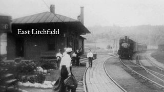
East Litchfield is an unincorporated village in the town of Litchfield, Litchfield County, Connecticut.

<span class="mw-page-title-main">Councils of governments in Connecticut</span> Subdivision of Connecticut, United States

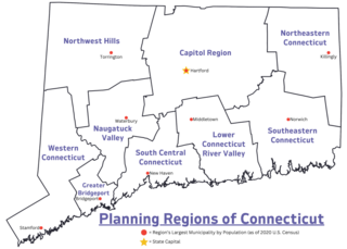
In Connecticut, councils of governments, also known as COGs, are regional planning organizations that bring together the chief elected officials or professional managers from member municipalities in Connecticut. Since 2015 and 2022, the Connecticut planning regions served by COGs have been recognized as county equivalents under state and federal law respectively, superseding the eight legacy counties in the state for most federal funding and statistical purposes.

The Berkshire League is a 9-team athletic conference of high schools, located in Litchfield County, Connecticut.

<span class="mw-page-title-main">Northwest Hills Planning Region, Connecticut</span> Planning region in Connecticut

The Northwest Hills Planning Region is a planning region and county-equivalent in Connecticut, United States. It is served by the coterminous Northwest Hills Council of Governments (NHCOG). In 2022, planning regions were approved to replace Connecticut's counties as county-equivalents for statistical purposes, with full implementation occurring by 2024.

References

  1. Cantele, Andi Marie (2012). Explorer's Guide Connecticut (8th ed.). Woodstock, Vt.: The Countryman Press. p. 226. ISBN   9780881509595 . Retrieved 24 April 2016.
  2. Taylor, Alex (11 October 2009). "What is a 'raggie'? Nickname's roots run deep in the Northwest Corner". The Register Citizen . Torrington, CT. Retrieved 8 February 2024.