Beacon Falls, Connecticut

Last updated

Beacon Falls, Connecticut
Town of Beacon Falls
BeaconFalls DepotStreetBridge.jpg
Depot Street Bridge, March 2017
BeaconFallsCtTownSeal.png
Beacon Falls CT lg.PNG
Beacon Falls, Connecticut
Coordinates: 41°26′20″N73°03′24″W / 41.43889°N 73.05667°W / 41.43889; -73.05667
CountryFlag of the United States.svg  United States
U.S. state Flag of Connecticut.svg  Connecticut
County New Haven
Region Naugatuck Valley
Incorporated1871
Government
  Type Selectman-town meeting
   First Selectman Gerard Smith (U) [1]
  SelectmenMichael A Krenesky (R)
Peter Betkoski (D)
Area
  Total9.9 sq mi (25.6 km2)
  Land9.8 sq mi (25.3 km2)
  Water0.1 sq mi (0.2 km2)
Elevation
207 ft (63 m)
Population
 (2020)
  Total6,000
Time zone UTC−5 (Eastern)
  Summer (DST) UTC−4 (Eastern)
ZIP Code
06403
Area code(s) 203/475
FIPS code 09-03250
GNIS feature ID0213387 [2]
Website www.beaconfalls-ct.org
Home Woolen Company, Beacon Falls, Connecticut BeaconFallsCT HomeWoolenCompany.jpg
Home Woolen Company, Beacon Falls, Connecticut

Beacon Falls is a town in western New Haven County, Connecticut, United States. The town is part of the Naugatuck Valley Planning Region & is around 6 miles from Waterbury. It lies in the southwestern part of the state, and is bisected by the Naugatuck River. The population was 6,000 at the 2020 census, down from 6,049 at the 2010 census. [3]

Contents

Founding

The area that was to become Beacon Falls was first inhabited by tribal communities of Paugusetts and Paugusucks and was originally known as Nyumps. [4] Early history texts indicate that a former Native American slave called Toby bought much of the land that was to become the town on September 7, 1693 for 10 pounds and a barrel of cider. [5]

Settlers from Derby, Connecticut moved to the area in 1678 and the town was incorporated in 1871 on lands carved from the neighboring towns of Bethany, Seymour, Naugatuck and Oxford. [6] The town was named for Beacon Hill, from which a small waterfall descended. [7]

History

The history of Beacon Falls is tied to the series of manufacturing concerns that operated in the town's impressive brick factory buildings on North Main Street, adjacent to the Naugatuck River. The last and most successful of those concerns was the Beacon Falls Rubber Shoe Company. During the late 19th and early 20th centuries rubber manufacturing thrived in the Lower Naugatuck Valley. This followed the invention and 1844 patent, by Connecticut native Charles Goodyear, of a chemical process called Vulcanization to convert natural rubber into a durable, flexible, waterproof material. In the 1850s the American Hard Rubber Company built a brick factory in Beacon Falls, utilizing water power from the Naugatuck River. The company made buttons, whip sockets, and powder flasks. After that company was acquired and moved to Long Island, the empty brick building was bought by the Home Woolen Company, which in the 1860s expanded and manufactured woolen shawls, popular at the time with men, women and Civil War soldiers. The Home Woolen Company operated for 20-plus years until it became insolvent in 1887.

The 1898 inception of the Beacon Falls Rubber Shoe Company lay in the decision of George Lewis, President of the Goodyear Metallic Rubber Shoe Co. of Naugatuck, Connecticut, and his son Tracy S. Lewis, Secretary and Treasurer of that company, to resign and start a new business together. In 1898 the two Lewis men bought the Home Woolen Company facility and started the Beacon Falls Rubber Shoe Company. The new company enjoyed great success for over two decades. From 150 pairs of shoes manufactured in 1899, by 1920 5.5 million pair were shipped; during that same time the town's population doubled. The company specialized in rubber soled boots with leather uppers (like today's "L.L. Bean boots"), and rubber soled athletic shoes with canvas uppers (now called "sneakers"). The footwear was marketed under the brand name, "Top Notch."

The Beacon Falls Rubber Shoe Company was a tremendous physical, economic, and cultural presence in Beacon Falls. It made major civic efforts to enhance the town and the lives of its employees, including building a movie theater, with an assembly room and dance hall for public use, sponsoring a musical band that gave daily performances, and commissioning the influential landscape architectural firm Olmsted Brothers to create an overall design for company lands and buildings. The resulting plan embraced the Tracy S. Lewis House and a neighborhood of workers' homes above the factory.

Tracy Lewis died prematurely in 1921 at age 47, marking the demise of the Beacon Falls Rubber Shoe Company, followed by the gradual end of manufacturing at the Beacon Falls facility. After Lewis's death, the company was acquired by the United States Rubber Company in Naugatuck (formerly Goodyear Metallic Rubber Shoe Co., renamed Uniroyal, Inc. in 1961), and the Beacon Falls athletic shoe was renamed "Keds." Production in the elegant brick factory buildings ended during the Great Depression in 1930, after which the buildings were used only for storage. Several buildings associated with the company, including the movie theater, were destroyed when the State of Connecticut widened the road in front of the factory in 1949, and when the Flood of 1955 (Connecticut) flooded the Naugatuck River, causing extensive damage through the valley. In 1984 the brick factory buildings were placed on the National Register of Historical Places as the "Home Woolen Company" (#84000410—"also known as Beacon Falls Rubber Shoe Factory"). In the late 1980s the buildings were converted to a 188-unit, full-amenity apartment complex called Beacon Mill Village. The "Depot Street Bridge," spanning the Naugatuck River across from the old brick factory, is also on the National Register of Historical Places (#07000108). Built in 1935 of riveted steel, it was designed by engineers from the Public Works Administration and the Connecticut Highway Department. The bridge joins the two parts of Beacon Falls bisected by the river.

A second major historical Beacon Falls business, where many town residents worked over the years, was the Homer D. Bronson Company. In 1884 the company moved to Beacon Falls from Waterbury, Connecticut (known as "the brass capital of the world"). The Homer D. Bronson Company manufactured a multitude of brass items, specializing in hinges used in industry and homes; automobile hood hinges were a major product. The company survived both the Great Depression and the Flood of 1955. Now named HDB Inc., its present-day website states that it has been "a leader in the engineered hinge and metal stamping markets since 1839." In 1986 the company moved to Winsted, Connecticut.

Significant people and events

Beacon Falls is home to the nationally known Meteorologist Jim Cantore and U.S. Congressman Ronald A. Sarasin.

On May 15, 2018 one of the four EF1 tornadoes that struck CT had a 9.1 mile path that started in Beacon Falls and caused serious damage to homes and infrastructure. [8]

Geography

According to the United States Census Bureau, the town has a total area of 9.9 square miles (26 km2), of which, 9.8 square miles (25 km2) of it is land and 0.1 square miles (0.26 km2) of it (1.01%) is water.

The village of Pine Bridge, once known as Pines Bridge, is located within the town, south of the town center. Beacon Falls has been known as Beacon Falls Station, Beacon Falls Village, and the Beacon Falls Postal District within Bethany. [9] [10]

The Beacon Falls (Metro-North station) is on the Waterbury branch of the New Haven line.

On the National Register of Historic Places

On the State Register of Historic Places

Demographics

Historical population
CensusPop.Note
1880 379
1890 50533.2%
1900 62323.4%
1910 1,16086.2%
1920 1,59337.3%
1930 1,6936.3%
1940 1,7563.7%
1950 2,06717.7%
1960 2,88639.6%
1970 3,54622.9%
1980 3,99512.7%
1990 5,08327.2%
2000 5,2463.2%
2010 6,04915.3%
2020 6,000−0.8%
U.S. Decennial Census [11]

As of the census of 2010, there were 6,049 people, divided into 2,509 total households, with 2,360 occupied households in the town. The racial makeup (population) of the town was 91.2% White, 1.4% African American, 1.2% Asian, and 0.8% from two or more races, while 5.0% identified as either Hispanic or Latino. [12]

As of the census [13] of 2000, there were 5,246 people, 2,032 households, and 1,450 families residing in the town. The population density was 536.6 inhabitants per square mile (207.2/km2). There were 2,104 housing units at an average density of 215.2 per square mile (83.1/km2). The racial makeup of the town was 96.97% White, 0.72% African American, 0.08% Native American, 1.03% Asian, 0.04% Pacific Islander, 0.40% from other races, and 0.76% from two or more races. Hispanic or Latino of any race were 2.13% of the population.

There were 2,032 households, out of which 34.1% had children under the age of 18 living with them, 58.2% were married couples living together, 9.5% had a female householder with no husband present, and 28.6% were non-families; 23.0% were made up of individuals, and 6.3% had someone living alone who was 65 years of age or older. The average household size was 2.58 and the average family size was 3.08.

In the town, the population was spread out, with 25.2% under the age of 18, 6.5% from 18 to 24, 35.1% from 25 to 44, 23.6% from 45 to 64, and 9.6% who were 65 years of age or older. The median age was 37 years. For every 100 females, there were 100.6 males. For every 100 females age 18 and over, there were 96.5 males.

The median income for a household in the town was $56,592, and the median income for a family was $62,461. Males had a median income of $41,696 versus $34,844 for females. The per capita income for the town was $25,285. About 4.2% of families and 5.9% of the population were below the poverty line, including 9.8% of those under age 18 and 4.6% of those age 65 or over.

Beacon Falls is home to Woodland Regional High School, which opened in 2001. Woodland is part of Regional School District #16 (Beacon Falls and Prospect), which also consists of Long River Middle School (P), Laurel Ledge Elementary School (BF), and Prospect Elementary School (P).

Voter registration and party enrollment as of October 29, 2019 [14]
PartyActive votersInactive votersTotal votersPercentage
Democratic 1126531,17925.06%
Republican 1164481,21225.76%
Unaffiliated 2,1091242,23347.46%
Minor Parties729811.72%
Total4,4712344,705100%
Past elections results
Beacon Falls town vote
by party in presidential elections [15]
Year Democratic Republican Third Parties
2020 40.6% 1,54357.6%2,1911.8% 69
2016 34.4% 1,14660.2%2,0025.4% 180
2012 43.9% 1,30054.0%1,5982.1% 61
2008 47.7% 1,48350.5%1,5761.8% 58
2004 41.5% 1,20656.0%1,6342.5% 74
2000 47.6%1,19845.9% 1,1586.5% 164
1996 45.4%1,05537.3% 86817.3% 404
1992 29.6% 76339.3%1,01931.1% 808
1988 43.1% 86655.6%1,1191.3% 27
1984 31.0% 59468.4%1,3110.6% 12
1980 34.7% 60654.4%95110.9% 191
1976 48.7% 88450.8%9220.5% 9
1972 38.4% 66860.0%1,0451.6% 28
1968 53.1%84136.3% 57610.6% 168
1964 72.7%1,13027.3% 4250.00% 0
1960 66.0%1,04434.0% 5400.00% 0
1956 47.2% 61952.8%6920.00% 0

Transportation

Beacon Falls train station, September 2018 Beacon Falls station from the parking lot, September 2018.JPG
Beacon Falls train station, September 2018

The Beacon Falls train station provides commuter rail service to Bridgeport, Stamford, and Grand Central Terminal in New York City via the Waterbury Branch on the Metro-North Railroad's New Haven Line. Beacon Falls lies along Connecticut Route 8. Connecticut Transit Waterbury Division provides bus service to Beacon Falls on its 479X route.

See also

Related Research Articles

<span class="mw-page-title-main">New Haven County, Connecticut</span> County in Connecticut, United States

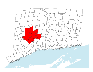
New Haven County is a county in the south central part of the U.S. state of Connecticut. As of the 2020 census, the population was 864,835, making it the third-most populous county in Connecticut. Two of the state's top 5 largest cities, New Haven (3rd) and Waterbury (5th), are part of New Haven County.

<span class="mw-page-title-main">Plymouth, Connecticut</span> Town in Connecticut, United States

Plymouth is a town in Litchfield County, Connecticut, United States, located within the Naugatuck Valley Planning Region. It is named after Plymouth, Devon, England. The population was 11,671 at the 2020 census, down from 12,243 at the 2010 census. The town of Plymouth includes the villages of Plymouth Center, Terryville and Pequabuck.

<span class="mw-page-title-main">Thomaston, Connecticut</span> Town in Connecticut, United States

Thomaston is a town in Litchfield County, Connecticut, United States. The town is part of the Naugatuck Valley Planning Region. The population was 7,442 at the 2020 census. The urban center of the town is the Thomaston census-designated place, with a population of 1,928 at the 2020 census.

<span class="mw-page-title-main">Watertown, Connecticut</span> Town in Connecticut, United States

Watertown is a town in Litchfield County, Connecticut, United States. The town is part of the Naugatuck Valley Planning Region. The population was 22,105 at the 2020 census. The ZIP Codes for Watertown are 06795 and 06779. It is a suburb of Waterbury. The urban center of the town is the Watertown census-designated place, with a population of 3,938 at the 2020 census.

<span class="mw-page-title-main">Middlebury, Connecticut</span> Town in Connecticut, United States

Middlebury is a town in New Haven County, Connecticut, United States. The population was 7,574 at the 2020 census. The town is part of the Naugatuck Valley Planning Region.

<span class="mw-page-title-main">Oxford, Connecticut</span> Town in Connecticut, United States

Oxford is a residential town located in western New Haven County, Connecticut, United States. The town is part of the Naugatuck Valley Planning Region. The population was 12,706 at the 2020 Census. Oxford is the 26th-wealthiest town in the state by median household income. Distinct settled areas in the town include Oxford Center, Quaker Farms, and Riverside. Oxford belongs to the Bridgeport–Stamford–Norwalk Metropolitan Statistical Area, a subregion of the New York metropolitan area.

<span class="mw-page-title-main">Prospect, Connecticut</span> Town in Connecticut, United States

Prospect is a town in the Naugatuck Valley Planning Region, Connecticut, United States. It is a suburb of the nearby city of Waterbury to its north, and is on the north-eastern fringes of the New York metropolitan area. The population was estimated to be 9,401 in 2020. Prospect is part of the Waterbury NECTA and of the historical New Haven County. Prospect is also a member of the regional health district Chesprocott, along with Cheshire and Wolcott.

<span class="mw-page-title-main">Seymour, Connecticut</span> Town in Connecticut, United States

Seymour is a town located in New Haven County, Connecticut, United States. The town is part of the Naugatuck Valley Planning Region. The population was 16,748 at the 2020 census. Seymour is bordered by the towns of Oxford and Beacon Falls to the north, Bethany and Woodbridge to the east, Ansonia and Derby to the south, and Shelton to the west.

<span class="mw-page-title-main">Wolcott, Connecticut</span> Town in Connecticut, United States

Wolcott is a town in New Haven County, Connecticut, United States. The town is part of the Naugatuck Valley Planning Region. It is primarily residential, with a population of 16,142 as of the 2020 United States Census.

<span class="mw-page-title-main">Bellows Falls, Vermont</span> Village in Vermont, United States

Bellows Falls is an incorporated village located in the town of Rockingham in Windham County, Vermont, United States. The population was 2,747 at the 2020 census. Bellows Falls is home to the Green Mountain Railroad, a heritage railroad; the annual Roots on the River Festival; and the No Film Film Festival.

<span class="mw-page-title-main">Ansonia, Connecticut</span> City in Connecticut, United States

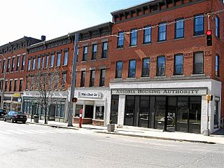
Ansonia is a city in New Haven County, Connecticut, United States. Located on the Naugatuck River, it is immediately north of Derby, and about 12 miles (19 km) northwest of New Haven. The city is part of the Naugatuck Valley Planning Region. The population was 18,918 at the time of the 2020 census. The ZIP code for Ansonia is 06401. The city is served by the Metro-North Railroad. Ansonia Station is a stop on the railroad passenger commuter service's Waterbury Branch connecting to New York's Grand Central Terminal. Ansonia also is served by the Connecticut Transit bus carrier. Connecticut Route 8 serves Ansonia.

<span class="mw-page-title-main">Derby, Connecticut</span> City in Connecticut, United States

Derby is a city in New Haven County, Connecticut, United States, approximately 8 miles (13 km) west-northwest of New Haven. It is located in southwest Connecticut at the confluence of the Housatonic and Naugatuck rivers. It shares borders with the cities of Ansonia to the north and Shelton to the southwest, and the towns of Orange to the south, Seymour to the northwest, and Woodbridge to the east. The city is part of the Naugatuck Valley Planning Region. The population was 12,325 at the 2020 census. It is the smallest city in Connecticut by area, at 5.3 square miles (14 km2).

<span class="mw-page-title-main">Naugatuck, Connecticut</span> Consolidated borough and town in Connecticut, US

Naugatuck is a consolidated borough and town in New Haven County, Connecticut, United States. The town, part of the Naugatuck Valley Planning Region, had a population of 31,519 as of the 2020 Census.

The Naugatuck River Valley is the watershed area of the Naugatuck River in the western part of Connecticut. The Naugatuck Valley straddles parts of Litchfield County, New Haven, and Fairfield counties. The Route 8 corridor and Waterbury Branch of the Metro-North railroad line run along the river valley. Geographically, it comprises the municipalities located within the Naugatuck River basin. During the 19th and 20th centuries, the area was one of the main manufacturing centers in New England, and most of the communities around the river were emblematic New England mill towns.

<span class="mw-page-title-main">Connecticut Route 8</span> Highway in Connecticut

Route 8 is a 67.36-mile (108.41 km) state highway in Connecticut that runs north–south from Bridgeport, through Waterbury, all the way to the Massachusetts state line where it continues as Massachusetts Route 8. Most of the highway is a four-lane freeway but the northernmost 8.8 miles (14.2 km) is a two-lane surface road.

<span class="mw-page-title-main">Naugatuck River</span> River in Connecticut, United States

The Naugatuck River is a 40.2-mile-long (64.7 km) river in the U.S. state of Connecticut. Its waters carve out the Naugatuck River Valley in the western reaches of the state, flowing generally due south and eventually emptying into the Housatonic River at Derby, Connecticut and thence 11 miles (18 km) to Long Island Sound. The Plume and Atwood Dam in Thomaston, completed in 1960 following the Great Flood of 1955, creates a reservoir on the river and is the last barrier to salmon and trout migrating up from the sea.

The Lower Naugatuck Valley, also known locally as simply "The Valley", is a geographic area located around the confluence of the southern parts of the Housatonic and Naugatuck Rivers. It consists of the municipalities of Seymour, Derby, Ansonia, and outside the Naugatuck watershed, Shelton, which constitute the Valley Council of Governments. The scope of the Lower Naugatuck Valley is also sometimes extended to encompass the next three towns upstream and to the north, which are Beacon Falls, Naugatuck, and Oxford, Connecticut.

<span class="mw-page-title-main">Central Naugatuck Valley</span> Place in Connecticut, United States

The Central Naugatuck Valley is a region of Connecticut in New Haven and Litchfield counties located approximately 70 miles (110 km) northeast of New York City and 110 miles (180 km) southwest of Boston, United States. The region comprises 13 towns: Beacon Falls, Bethlehem, Cheshire, Middlebury, Naugatuck, Oxford, Prospect, Southbury, Thomaston, Waterbury, Watertown, Wolcott, and Woodbury.

<span class="mw-page-title-main">Tracy S. Lewis House</span>

Tracy S. Lewis was a principal and founder of the Beacon Falls Rubber Shoe Company, which dominated the economy of Beacon Falls, Connecticut during the first decades of the 20th century. The Tracy S. Lewis House is the home he built and lived in Beacon Falls. There is currently a debate over the town's decision to raze the house.

<span class="mw-page-title-main">Home Woolen Company</span> United States historic place

The Home Woolen Company is a historic textile mill complex on Main Street in Beacon Falls, Connecticut. Developed between 1853 and 1916, the complex housed major local employers, engaged first in the manufacture of woolens and rubber products. The complex has been converted to residential use. It was listed on the National Register of Historic Places in 1984.

References

  1. "Smith wins first selectman seat in Beacon Falls". November 6, 2019.
  2. "Town of Beacon Falls". Geographic Names Information System . United States Geological Survey, United States Department of the Interior . Retrieved July 16, 2023.
  3. "Census - Geography Profile: Beacon Falls town, New Haven County, Connecticut" . Retrieved November 26, 2021.
  4. "Beacon Falls". connecticuthistory.org. September 12, 2011. Retrieved June 1, 2018.
  5. Mark Heiss; Beacon Falls Historical Society (2012). Beacon Falls. Arcadia Publishing. pp. 1–. ISBN   978-0-7385-9143-8.
  6. The Connecticut Magazine: An Illustrated Monthly. Connecticut Magazine Company. 1903. p. 330.
  7. "Acquisition of the land and first settlers" (PDF). beaconfalls-ct.org. 1871. Archived (PDF) from the original on September 5, 2021. Retrieved September 4, 2021.
  8. Puffer, Michael (May 16, 2018). "Tornado leaves dangerous conditions in its wake: Aftermath is 'horrifying'". Republican-American. Archived from the original on August 4, 2018. Retrieved May 31, 2018.
  9. "The Valley of the Naugatuck", National Magazine, January 1858, pg 11-20
  10. "Indians of the Housatonic and Naugatuck Valleys", Samuel Orcutt, Case, Lockwood & Brainard Company, pg 44, 1882
  11. "Census of Population and Housing". Census.gov. Retrieved June 4, 2015.
  12. Connecticut State Data Center. (2011). Connecticut Town Population 2010 & 2000. Retrieved from "Connecticut State Data Center - 2010 US Census PL 94-171 Change Viewer". Archived from the original on March 21, 2011. Retrieved April 3, 2011.
  13. "U.S. Census website". United States Census Bureau . Retrieved January 31, 2008.
  14. "Registration and Party Enrollment Statistics as of October 29, 2019" (PDF). Connecticut Secretary of State. Retrieved February 17, 2020.
  15. "Public Reporting".