Orange, Connecticut

Last updated

Orange, Connecticut
Town of Orange
Orange CT town hall.jpg
Orange Town Hall
FlagOfOrangeCT.png
SealOfOrangeCT.png
New Haven County Connecticut Incorporated and Unincorporated areas Orange Highlighted.svg
Orange, Connecticut
Orange, Connecticut
Orange, Connecticut
Coordinates: 41°16′46″N73°01′31″W / 41.27944°N 73.02528°W / 41.27944; -73.02528
CountryFlag of the United States.svg  United States
U.S. state Flag of Connecticut.svg  Connecticut
County New Haven
Region South Central CT
Incorporated1822
Government
  Type Selectman-town meeting
  First selectmanJames M. Zeoli (R)
  SelectmenRalph Okenquist (R)
John Carangelo (R)
Judy W. Williams (R)
Connor Deane (D)
Mitchell R. Goldblatt (D)
Area
  Total17.4 sq mi (45.1 km2)
  Land17.2 sq mi (44.5 km2)
  Water0.2 sq mi (0.6 km2)
Elevation
213 ft (65 m)
Population
 (2020)
  Total14,280
  Density820/sq mi (320/km2)
Time zone UTC-5 (Eastern)
  Summer (DST) UTC-4 (Eastern)
ZIP code
06477
Area code(s) 203/475
FIPS code 09-57600
GNIS feature ID0213485
Website www.orange-ct.gov

Orange is a town in New Haven County, Connecticut, United States. The town is part of the South Central Connecticut Planning Region. The population was 14,280 at the 2020 census. [1] The town is governed by a Board of Selectmen.

Contents

History

The Paugusset and Algonquian people previously inhabited the region that is now Orange. In 1639, Rev. Peter Prudden purchased the land from the Native Americans for six coats, ten blankets, one kettle, twelve hatchets, twelve hoes, two dozen knives and a dozen small mirrors. [2] When originally settled by English colonists, Orange was the northern and eastern district of the now neighboring city of Milford; however, by 1822, the population of the area had grown to the point where residents desired to form their own separate community, thus forming the town of Orange.

The town is named after William III of England, who was Prince of Orange from birth. [3] William is remembered for succeeding James II, deposed in the Glorious Revolution of 1688. James II had been considered a despot in Connecticut; he had famously and unsuccessfully commissioned Edmund Andros to seize Connecticut's Charter. [4]

The town continued to grow throughout the 19th century. As early as 1848, a separation of Orange and West Haven was considered. It was not until 1921 that the two were officially separated by act of the Connecticut General Assembly and the new city of West Haven was formed out of the southeastern portion of Orange. [4] This left Orange a largely rural town, as the bulk of the urbanized population was ceded to West Haven. In the post-war years, however, Orange began suburbanizing at a rapid pace.

Early roads through the area included the Boston Post Road (now U.S. Route 1) and the Derby Turnpike (now Connecticut Route 34). The turnpike was originally an Indian path. A toll road through Orange, from New Haven to Derby, was built starting in 1800. The toll house was located in Orange; tolls ended in 1887. [5] The New Haven and Derby Railroad ran through Orange starting in 1871, with a station in Orange. At its peak, there were eleven trains per day in each direction along with one freight train. The advent of a trolley from New Haven to Derby (starting in 1904 and running until 1937) hastened the end to rail service (in 1925). [5] Later, the construction of the Wilbur Cross Parkway and Interstate 95 brought highways through the area.

Geography

According to the United States Census Bureau, the town has a total area of 17.4 square miles (45.1 km2), of which 17.2 square miles (44.5 km2) is land and 0.2 square miles (0.6 km2), or 1.38%, is water. It is bordered on the south by Milford, on the east by West Haven, on the north by New Haven, Woodbridge and Derby and on the west by the Housatonic River and Shelton. The town limits include Wooster Island in the Housatonic River. The Wepawaug, Indian and Oyster rivers flow through the town.

Demographics

Historical population
YearPop.±%
1830 1,341    
1840 1,329−0.9%
1850 1,476+11.1%
1860 1,974+33.7%
1870 2,634+33.4%
1880 3,341+26.8%
1890 4,537+35.8%
1900 6,995+54.2%
1910 11,272+61.1%
1920 16,614+47.4%
1930 [6] 1,530−90.8%
1940 2,009+31.3%
1950 3,032+50.9%
1960 8,547+181.9%
1970 13,524+58.2%
1980 13,237−2.1%
1990 12,830−3.1%
2000 13,233+3.1%
2010 13,956+5.5%
2020 14,280+2.3%

As of the census of 2000, [7] there were 13,233 people, 4,739 households, and 3,895 families residing in the town. The population density was 770.0 inhabitants per square mile (297.3/km2). There were 4,870 housing units at an average density of 283.4 per square mile (109.4/km2). The racial makeup of the town was 94.08% White, 0.79% Black or African American, 0.08% Native American, 3.84% Asian, 0.01% Pacific Islander, 0.32% from other races, and 0.88% from two or more races. Hispanic or Latino of any race were 1.44% of the population.

There were 4,739 households, out of which 35.1% had children under the age of 18 living with them, 73.1% were married couples living together, 6.7% had a female householder with no husband present, and 17.8% were non-families. 15.7% of all households were made up of individuals, and 10.0% had someone living alone who was 65 years of age or older. The average household size was 2.77 and the average family size was 3.09.

In the town, the population was spread out, with 24.6% under the age of 18, 4.3% from 18 to 24, 24.5% from 25 to 44, 26.7% from 45 to 64, and 19.9% who were 65 years of age or older. The median age was 43 years. For every 100 females, there were 94.5 males. For every 100 females age 18 and over, there were 91.1 males.

The median income for a household in the town was $79,365, and the median income for a family was $88,583. Males had a median income of $58,946 versus $41,563 for females. The per capita income for the town was $36,471. About 2.1% of families and 2.5% of the population were below the poverty line, including 1.4% of those under age 18 and 4.3% of those age 65 or over. [8]

Registration and party enrollment statistics as of October 26, 2010 [9]
PartyActive votersInactive votersTotal voters
Republican 2,455212,476
Democratic 2,502222,524
Unaffiliated 5,172445,216
Minor parties23124
Total10,1528810,240

Economy

Orange is the home of the North American headquarters of Pez candies. [10] [11] It is also the home of the headquarters of Avangrid and its subsidiaries Southern Connecticut Gas [12] and The United Illuminating Company. [13]

Tangoe, Inc., a provider of telecommunications management software, was formerly headquartered in Orange. [14] Orange was the home of the US headquarters of Saab-Scania from 1972 until 1992 when the company relocated to Norcross, Georgia. [15] From 1973–2010, Hubbell, a manufacturer of electrical products, was headquartered in Orange. [16] In 2013, the University of New Haven purchased the former Hubbell headquarters buildings to redevelop as a graduate school campus. [17] Yale's West Campus is located on the Orange-West Haven town line, on a 136-acre property that was formerly occupied by Bayer. In 2013, the Yale School of Nursing relocated to a building on the Yale West Campus that is mostly on the Orange side of the town border. [18]

About three percent of the 17 square miles in the town is farmed. [19] Field View Farm, one of the oldest businesses in the United States, has been operated by the Hine family since 1639. [20] [21] Orange was also formerly home to the Everett B. Clark Seed Company which eventually joined forces with other local seed growers to form Asgrow, now a division of Bayer. [22]

The town has extensive retail development along the Boston Post Road corridor. [19]

During the Cold War, Orange was a location for the permanent deployment of Nike missiles for the defense of Greater New Haven. The former site of the Nike missiles has since (from the late 1950s onward) been the home of the 103rd Air Control and Warning Squadron, later to become the 103rd Tactical Control Squadron and as it remains today the 103rd Air Control Squadron, a part of the Connecticut Air National Guard. [23] [24]

Arts and culture

Events

Orange exhibits its rural roots at the annual Orange Country Fair. This event originally ran from 1898 to 1912 and was revived in 1975. It has continued since then featuring horse, oxen and tractor pulls as well as exhibits of animals, flowers, fruits, vegetables and baked goods. [25] In early August, the town also promotes the Orange Volunteer Fireman's Carnival, which raises funds to support the volunteer fire department. Both events are held at the fairgrounds at High Plains Community Center near the center of town.

Orange was the site of one of the earliest computer camps, [26] [27] held at the local Amity Jr. High School in 1977.

In the early nineteenth century, settlers from Orange founded Orange, Ohio, then part of Connecticut's Western Reserve.

On March 15–17, 2009, Orange hosted the 2009 ConnJam, a Boy Scout event in which over 3,000 Boy Scouts from the Connecticut Yankee Council attended events and camped over the weekend. [28] [29]

On the National Register of Historic Places

The Academy Orange-ct-the-academy.jpg
The Academy
Case Memorial Library Case memorial library orange ct usa.jpg
Case Memorial Library

Library

Sports

On August 18, 2005 the Orange Little League Girls softball team lost the championship game of the Little League Softball World Series to a team from McLean, Virginia. [33] [34]

Education

Orange is served by the regional Amity Regional High School in Woodbridge. [35] Schools include:

Southern Connecticut Hebrew Academy (formerly New Haven Hebrew Day School) is located here.[ citation needed ]

Notable people

Related Research Articles

<span class="mw-page-title-main">New Haven, Connecticut</span> City in Connecticut, United States

New Haven is a city in New Haven County, Connecticut, United States. It is located on New Haven Harbor on the northern shore of Long Island Sound and is part of the New York City metropolitan area. With a population of 135,081 as determined by the 2020 U.S. census, New Haven is the third largest city in Connecticut after Bridgeport and Stamford, the largest city in the South Central Connecticut Planning Region, and the principal municipality of Greater New Haven, which had a total population of 864,835 in 2020. Prior to 1960, it was the county seat of New Haven County until the county governments were abolished that year.

<span class="mw-page-title-main">Fairfield County, Connecticut</span> County in Connecticut, United States

Fairfield County is a county in the southwestern corner of the U.S. state of Connecticut. It is the most populous county in the state and was also its fastest-growing from 2010 to 2020. As of the 2020 census, the county's population was 957,419, representing 26.6% of Connecticut's overall population. The closest to the center of the New York metropolitan area, the county contains four of the state's top 7 largest cities—Bridgeport (1st), Stamford (2nd), Norwalk (6th), and Danbury (7th)—whose combined population of 433,368 is nearly half the county's total population.

<span class="mw-page-title-main">New Haven County, Connecticut</span> County in Connecticut, United States

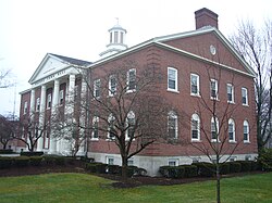
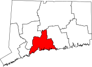
New Haven County is a county in the south central part of the U.S. state of Connecticut. As of the 2020 census, the population was 864,835, making it the third-most populous county in Connecticut. Two of the state's top 5 largest cities, New Haven (3rd) and Waterbury (5th), are part of New Haven County.

<span class="mw-page-title-main">Greenwich, Connecticut</span> Town in Connecticut, United States

Greenwich is a town in southwestern Fairfield County, Connecticut, United States. At the 2020 census, the town had a total population of 63,518. The largest town on Connecticut's Gold Coast, Greenwich is home to many hedge funds and other financial services firms. Greenwich is a principal community of the Bridgeport–Stamford–Norwalk–Danbury metropolitan statistical area, which comprises all of Fairfield County. The town is part of the Western Connecticut Planning Region.

<span class="mw-page-title-main">Bethany, Connecticut</span> Town in Connecticut, United States

Bethany is a town in New Haven County, Connecticut, United States. The town is part of the South Central Connecticut Planning Region. The population was 5,297 at the 2020 census.

<span class="mw-page-title-main">Cheshire, Connecticut</span> Town in Connecticut, United States

Cheshire, formerly known as New Cheshire Parish, is a town in New Haven County, Connecticut, United States. At the time of the 2020 census, the population of Cheshire was 28,733. The town is part of the Naugatuck Valley Planning Region. The center of population of Connecticut is located in Cheshire.

<span class="mw-page-title-main">Seymour, Connecticut</span> Town in Connecticut, United States

Seymour is a town located in New Haven County, Connecticut, United States. The town is part of the Naugatuck Valley Planning Region. The population was 16,748 at the 2020 census. Seymour is bordered by the towns of Oxford and Beacon Falls to the north, Bethany and Woodbridge to the east, Ansonia and Derby to the south, and Shelton to the west.

<span class="mw-page-title-main">Wallingford, Connecticut</span> Town in Connecticut, United States

Wallingford is a town in New Haven County, Connecticut, United States, centrally located between New Haven and Hartford, and Boston and New York City. The town is part of the South Central Connecticut Planning Region. The population was 44,396 at the 2020 census. The community was named after Wallingford, in England.

<span class="mw-page-title-main">Woodbridge, Connecticut</span> Town in Connecticut, United States

Woodbridge is a town in New Haven County, Connecticut, United States. The town is part of the South Central Connecticut Planning Region. The population was 9,087 at the 2020 census. The town center is listed on the National Register of Historic Places as Woodbridge Green Historic District. Woodbridge is part of the Amity Regional School District #5, rated the #1 school district in New Haven County and the 10th best school district in CT by Niche in 2021. As of 2019 Woodbridge has the 7th highest median household income in CT.

<span class="mw-page-title-main">Milford, Connecticut</span> City in Connecticut, United States

Milford is a coastal city in New Haven County, Connecticut, United States, between New Haven and Bridgeport. The population was 50,558 at the 2020 United States Census. The city includes the village of Devon and the borough of Woodmont. Milford is part of the South Central Connecticut Planning Region and New York metropolitan area.

<span class="mw-page-title-main">Ansonia, Connecticut</span> City in Connecticut, United States

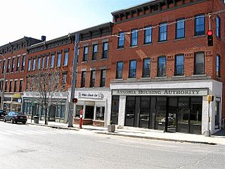
Ansonia is a city in New Haven County, Connecticut, United States. Located on the Naugatuck River, it is immediately north of Derby, and about 12 miles (19 km) northwest of New Haven. The city is part of the Naugatuck Valley Planning Region. The population was 18,918 at the time of the 2020 census. The ZIP code for Ansonia is 06401. The city is served by the Metro-North Railroad. Ansonia Station is a stop on the railroad passenger commuter service's Waterbury Branch connecting to New York's Grand Central Terminal. Ansonia also is served by the Connecticut Transit bus carrier. Connecticut Route 8 serves Ansonia.

<span class="mw-page-title-main">Derby, Connecticut</span> City in Connecticut, United States

Derby is a city in New Haven County, Connecticut, United States, approximately 8 miles (13 km) west-northwest of New Haven. It is located in southwest Connecticut at the confluence of the Housatonic and Naugatuck rivers. It shares borders with the cities of Ansonia to the north and Shelton to the southwest, and the towns of Orange to the south, Seymour to the northwest, and Woodbridge to the east. The city is part of the Naugatuck Valley Planning Region. The population was 12,325 at the 2020 census. It is the smallest city in Connecticut by area, at 5.3 square miles (14 km2).

<span class="mw-page-title-main">Shelton, Connecticut</span> City in Connecticut, United States

Shelton is a city in Fairfield County, Connecticut, United States. The population was 40,869 at the 2020 United States Census. The city is part of the Naugatuck Valley Planning Region.

<span class="mw-page-title-main">Newington, Connecticut</span> Town in Connecticut, United States

Newington is a town in Hartford County, Connecticut, United States. Located 8 miles (13 km) south of downtown Hartford, Newington is an older, mainly residential suburb located in Greater Hartford. As of 2023, the population is 30,527. The Connecticut Department of Transportation has its headquarters in Newington.

<span class="mw-page-title-main">East Haven, Connecticut</span> Town in Connecticut, United States

East Haven is a town in New Haven County, Connecticut, in the United States. As of the 2020 census, the town population was 27,923. The town is located 3 miles (5 km) east of New Haven, and is part of the South Central Connecticut Planning Region. East Haven is 35 miles (56 km) from Hartford, 82 miles (132 km) from New York City, 99 miles (159 km) from Providence, Rhode Island, and 140 miles (230 km) from Boston.

<span class="mw-page-title-main">West Haven, Connecticut</span> City in Connecticut, United States

West Haven is a city in New Haven County, Connecticut, United States, located on the coast of Long Island Sound. The city is part of the South Central Connecticut Planning Region. At the 2020 census, the population of the city was 55,584.

<span class="mw-page-title-main">West Haven station</span> Railroad station in Connecticut

West Haven station is a commuter rail station on the Metro-North Railroad's New Haven Line, located in West Haven, Connecticut. The station was built on Sawmill Road between Hood Terrace and Railroad Avenue, in the Elm Street-Wagner Place neighborhood. West Haven has 660 parking spaces in on-site lots as well as bicycle facilities. The station is accessible. West Haven has full service on the New Haven Line, as well as from the handful of Shore Line East trains which run past New Haven to Stamford.

<span class="mw-page-title-main">Amity Regional High School</span> Public school in Woodbridge, Connecticut, United States

Amity High School is a regional public high school located in Woodbridge, Connecticut, United States. It provides high school education for the children in the towns of Woodbridge, Orange, and Bethany. The name Amity is derived from both the colonial history of Woodbridge as well as the "friendship" demonstrated among the three founding towns in arranging for a communal educational program.

<span class="mw-page-title-main">Bridgeport, Connecticut</span> City in the United States

Bridgeport is the most populous city in the U.S. state of Connecticut and the fifth-most populous city in New England, with a population of 148,654 in 2020. Located in eastern Fairfield County at the mouth of the Pequonnock River on Long Island Sound, it is a port city 60 miles (97 km) from Manhattan and 40 miles (64 km) from The Bronx. It is bordered by the towns of Trumbull to the north, Fairfield to the west, and Stratford to the east. Bridgeport and other towns in Fairfield County make up the Greater Bridgeport Planning Region, as well as the Bridgeport–Stamford–Norwalk–Danbury metropolitan statistical area, the second largest metropolitan area in Connecticut. The Bridgeport–Stamford–Norwalk–Danbury metropolis forms part of the New York metropolitan area.

Orange station is a planned commuter rail stop that would serve the Metro-North Railroad's New Haven Line in Orange, Connecticut. The station will be located at Marsh Hill Road and a new access road. In early 2017, the station was planned to open in fall 2021, but budget difficulties at the end of the year canceled the plan for the time being.

References

  1. "Census - Geography Profile: Orange town, New Haven County, Connecticut". United States Census Bureau . Retrieved December 18, 2021.
  2. "Welcome to the Town of Orange". www.orange-ct.gov. Archived from the original on October 21, 2003.
  3. The Connecticut Magazine: An Illustrated Monthly. Connecticut Magazine Company. 1903. p. 334.
  4. 1 2 History of Orange Archived September 26, 2006, at the Wayback Machine
  5. 1 2 "The Derby Turnpike, Priscilla Searles, Business New Haven, Jan 27, 1997". Conntact.com. January 27, 1997. Archived from the original on January 19, 2013. Retrieved January 9, 2013.
  6. The more densely settled eastern part of Orange was split off as the town of West Haven in 1921, leading to the drop in population.
  7. United States Census Data: General
  8. United States Census Data: Economic
  9. "Registration and Party Enrollment Statistics as of October 26, 2010" (PDF). Connecticut Secretary of State. Archived from the original (PDF) on February 1, 2015. Retrieved October 2, 2006.
  10. About us, Pez Candy, Inc.
  11. Albert, Bridget (March 2, 2012). "Candy Land: PEZ draws fans to Orange headquarters for tours". The New Haven Register. Retrieved December 11, 2012.
  12. "Southern Connecticut Gas - Contact Us" . Retrieved June 24, 2013.
  13. Albert, Bridget (April 27, 2012). "Orange businesses happy with UI move". The New Haven Register. Retrieved December 11, 2012.
  14. "Tangoe, Inc. - Orange, CT - Corporate Headquarters". Archived from the original on May 1, 2013. Retrieved June 24, 2013.
  15. "SAAB-SCANIA of America – 60 Marsh Hill Rd, Orange, CT". Saab History. October 24, 2007. Retrieved October 24, 2010.
  16. Prevost, Lisa (May 7, 2010). "Hubbell Plans Housing for Its Orange Site". The New York Times. Retrieved June 24, 2013.
  17. Misur, Susan (February 7, 2013). "University of New Haven looking to buy Hubbell property in Orange". The New Haven Register. Retrieved June 26, 2013.
  18. Shelton, Jim (June 22, 2013). "Move-in day nears for Yale's new nursing school, campus on Orange-West Haven line bustling". The New Haven Register. Retrieved June 24, 2013.
  19. 1 2 3 Hughes, C.J. (September 30, 2011). "For Nature Lovers Who Also Shop-Hop". The New York Times. Retrieved June 24, 2013.
  20. "350-Year-Old Farm Survives the Odds". New York Times . March 13, 1989. Retrieved March 28, 2012.
  21. "7 Companies Older Than America". Inc. July 3, 2012. Retrieved September 26, 2012.
  22. "Orange Seeds Yield Corn, Alfafa, Soy, and More". Connecticuthistory.org. August 6, 2021. Retrieved June 8, 2022.
  23. "103rd Airlift Wing, Connecticut Air National Guard - Proud Heritage". The Official Web Site of 103rd Airlift Wing. Retrieved October 24, 2010.
  24. "103rd Air Control Squadron". Archived from the original on June 17, 2012. Retrieved October 24, 2010.
  25. "Orange Country Fair, Library of Congress Local Legacies". Lcweb2.loc.gov. Retrieved January 9, 2013.
  26. Harvey, Helen (June 9, 2002). "Computer pioneer made a lot of campers happy". The New Haven Register. Retrieved December 11, 2012.
  27. Humphrey, Mary (June 1982). "Learning With Computers". Compute! Magazine. Retrieved December 11, 2012.
  28. "Scout Jamboree in Orange". WTNH. LIN Television Corporation. May 16, 2009. Retrieved October 24, 2010.
  29. "Connecticut Yankee Council, BSA". Connecticut Yankee Council. Retrieved October 24, 2010.
  30. 1 2 "CT Trust for Historic Preservation". Cttrust.org. Retrieved January 9, 2013.
  31. Orange Connecticut Historic District
  32. 1 2 Liz Deluca, "The Historic District, A Walking Tour", Our Town Newspaper, June 10, 1997, pages 9-11.
  33. "SOUR ENDING Orange's bid for crown, perfection denied". New Haven Register. Journal Register Company. August 19, 2005. Retrieved October 24, 2010.
  34. "Virginia beats Connecticut to win title". Associated Press. August 19, 2005. Retrieved October 24, 2010.
  35. "Amity High School". Archived from the original on January 27, 2013. Retrieved February 26, 2013.