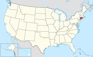
Fairfield County is a county in the southwestern corner of the U.S. state of Connecticut. It is the most populous county in the state and was also its fastest-growing from 2010 to 2020. As of the 2020 census, the county's population was 957,419, representing 26.6% of Connecticut's overall population. The closest to the center of the New York metropolitan area, the county contains four of the state's top 7 largest cities—Bridgeport (1st), Stamford (2nd), Norwalk (6th), and Danbury (7th)—whose combined population of 433,368 is nearly half the county's total population.

Easton is a town in Fairfield County, Connecticut, United States. As of the 2020 census, the population was 7,605. Easton contains the historic district of Aspetuck and the Plattsville census-designated place. It is a part of the Greater Bridgeport Planning Region, the New York metropolitan statistical area, and is bordered by the towns of Fairfield to the south, Redding to the north, Weston to the west, and Monroe and Trumbull to the east.
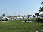
Monroe is a town located in eastern Fairfield County, Connecticut, United States. The population was 18,825 at the 2020 census. The town is part of the Greater Bridgeport Planning Region.

Trumbull is a town located in Fairfield County, Connecticut, United States. The town is part of the Greater Bridgeport Planning Region, and borders on the cities of Bridgeport and Shelton, as well as the towns of Stratford, Fairfield, Easton and Monroe. The population was 36,827 during the 2020 census. Trumbull was the home of the Golden Hill Paugussett Indian Nation for thousands of years before the English settlement was made in 1639. The town was named after Jonathan Trumbull (1710–1785), a merchant, patriot and statesman, at its incorporation in 1797. Aviation pioneer Igor Sikorsky lived in Trumbull during his active years when he designed, built, and flew fixed-wing aircraft and put the helicopter into mass production for the first time.

Greater New Haven is the metropolitan area whose extent includes those towns in the U.S. state of Connecticut that share an economic, social, political, and historical focus on the city of New Haven. It occupies the south-central portion of the state, in a radius around New Haven.

Area codes 203 and 475 are telephone area codes in the North American Numbering Plan (NANP) for the southwestern part of the U.S. state of Connecticut. The numbering plan area (NPA) is mostly coextensive with the Connecticut portion of the New York metropolitan area, and comprises most of Fairfield County, all of New Haven County, and a small portion of Litchfield County.

Stamford-Bridgeport-Norwalk is a metropolitan area in the U.S. state of Connecticut. The area is located in Southwestern Connecticut. In its most conservative form the area consists of the city of Bridgeport and five surrounding towns—Easton, Fairfield, Monroe, Stratford, and Trumbull. This definition of the Stamford area has a population of more than 305,000 and is within the Stamford -Bridgeport-Norwalk-Danbury metropolitan statistical area, which consists of all of Fairfield County, Connecticut. The estimated 2015 county population was 948,053. The area is numbered as part of the New York-Newark Combined Statistical Area NY-NJ-CT-PA by the United States Census Bureau.
Hersam Acorn Newspapers was a family-owned weekly newspaper company based in Ridgefield, Connecticut, United States. The company published 19 weeklies in Fairfield and New Haven counties, Connecticut, and Westchester County, New York, and several shopper publications in Connecticut, Massachusetts, New York and Vermont.

Greater Danbury, also known as the Housatonic Valley Region, is a region in the state of Connecticut centered on the city of Danbury. It consists of the city of Danbury and adjacent towns in the areas around the Housatonic River and the Still River. The area is also home to Candlewood Lake, the largest lake in the New York metropolitan area.

Greater Bridgeport Transit (GBT) is a transit service serving the Greater Bridgeport region of the U.S. state of Connecticut. GBT provides local bus service to the cities/towns of Bridgeport, Trumbull, Stratford, Milford, Fairfield, Westport, Shelton, and Monroe. The fleet is composed of mainly New Flyer Xcelsior and New Flyer Low Floor, as well as Gillig Low Floor and two Proterra Catalyst BE40 models.
Dan Debicella is a former State Senator and businessman, who represented the 21st district in the Connecticut State Senate. He was also the 2010 and 2014 Republican candidate for Connecticut's Fourth Congressional District.
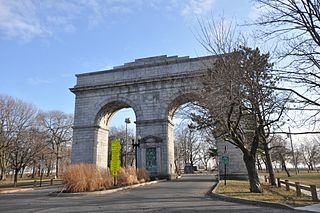
Bridgeport is the most populous city in the U.S. state of Connecticut and the fifth-most populous city in New England, with a population of 148,654 in 2020. Located in eastern Fairfield County at the mouth of the Pequonnock River on Long Island Sound, it is a port city 60 miles (97 km) from Manhattan and 40 miles (64 km) from The Bronx. It borders the towns of Trumbull to the north, Fairfield to the west, and Stratford to the east. Bridgeport and other towns in Fairfield County make up the Greater Bridgeport Planning Region, as well as the Bridgeport–Stamford–Norwalk–Danbury metropolitan statistical area, the second largest metropolitan area in Connecticut. The Bridgeport–Stamford–Norwalk–Danbury metropolis forms part of the New York metropolitan area.

The Pequonnock River is a 16.7-mile-long (26.9 km) waterway in eastern Fairfield County, Connecticut. Its watershed is located in five communities, with the majority of it located within Monroe, Trumbull, and Bridgeport. The river has a penchant for flooding, particularly in spring since the removal of a retention dam in Trumbull in the 1950s. There seems to be a sharp difference of opinion among historians as to just what the Indian word Pequonnock signifies. Some insist it meant cleared field or open ground; others are sure it meant broken ground; while a third group is certain it meant place of slaughter or place of destruction.

Long Hill is a neighborhood and census-designated place (CDP) in the town of Trumbull in Fairfield County, Connecticut, United States. It is located west of the Pequonnock River. The main thoroughfare is Connecticut Route 111, present-day Main Street. It was listed as a census-designated place prior to the 2020 census.
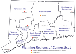
In Connecticut, councils of governments, also known as COGs, are regional planning organizations that bring together the chief elected officials or professional managers from member municipalities in Connecticut. Since 2015 and 2022, the Connecticut planning regions served by COGs have been recognized as county equivalents under state and federal law respectively, superseding the eight legacy counties in the state for most federal funding and statistical purposes.
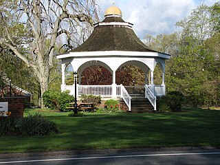
Trumbull Center is a section or neighborhood of the town of Trumbull in Fairfield County, Connecticut in New England. It is considered the center of the town, and was the seat of town government from 1883 through 1957. The Pequonnock River flows through the center in an easterly direction. The main thoroughfare is Connecticut Route 127.

The Gold Coast, also known as Lower Fairfield County or Southwestern Connecticut not limited to the Connecticut panhandle, is an affluent part of Western Connecticut that includes the entire southern portion of Fairfield County as defined by the U.S. Census Bureau, Super-Public Use Microdata Area (Super-PUMA) Region 09600. The area is about 50 miles (80 km) northeast of New York City, and is home to many wealthy Manhattan business executives. Parts of the region are served by the Western Connecticut Council of Governments.

The Lower Connecticut River Valley Planning Region is a planning region and county-equivalent in Connecticut. It is served by the coterminous Lower Connecticut River Valley Council of Governments (RiverCOG). In 2022, planning regions were approved to replace Connecticut's counties as county-equivalents for statistical purposes, with full implementation occurring by 2024.

The Western Connecticut Planning Region is a planning region and county-equivalent in Connecticut. It is served by the coterminous Western Connecticut Council of Governments (WestCOG), one of nine regional councils of governments in Connecticut. Within the region, there are two Metropolitan Planning Organizations, South Western CT MPO and the Housatonic Valley MPO.