Harwinton, Connecticut

Last updated

Harwinton, Connecticut
Town of Harwinton
TownHallHarwintonCT.jpg
Harwinton Town Hall
HarwintonCTSeal2.JPG
Litchfield County Connecticut Incorporated and Unincorporated areas Harwinton Highlighted 2010.svg
Harwinton, Connecticut
Coordinates: 41°45′16″N73°03′25″W / 41.75444°N 73.05694°W / 41.75444; -73.05694
CountryFlag of the United States.svg  United States
U.S. state Flag of Connecticut.svg  Connecticut
County Litchfield
Region Northwest Hills
Incorporated1737
Government
  Type Selectman-town meeting
  First selectmanMichael R. Criss (R)
  SelectmanEvan Brunetti
  SelectmanPaul Honig
Area
  Total31.2 sq mi (80.7 km2)
  Land30.8 sq mi (79.8 km2)
  Water0.3 sq mi (0.9 km2)
Elevation
794 ft (242 m)
Population
 (2020) [1]
  Total5,484
  Density178/sq mi (68.7/km2)
Time zone UTC−5 (Eastern)
  Summer (DST) UTC−4 (Eastern)
ZIP code
06791
Area code(s) 860/959
FIPS code 09-37280
GNIS feature ID0213444
Website www.harwinton.us

Harwinton is a town in Litchfield County, Connecticut, United States. The population was 5,484 at the 2020 census. [2] The town is part of the Northwest Hills Planning Region. The high school is Lewis S. Mills.

Contents

History

The town incorporated in 1737. [3] The name of the town alludes to Hartford and Windsor, Connecticut (HAR + WIN) followed by the suffix -ton, meaning town. [4]

Geography

Harwinton is in eastern Litchfield County; it is bordered to the northwest by the city of Torrington and to the east by Burlington in Hartford County. Hartford, the state capital, is 23 miles (37 km) to the east, and Bristol is 11 miles (18 km) to the southeast.

According to the United States Census Bureau, the town of Harwinton has a total area of 31.2 square miles (80.7 km2), of which 30.8 square miles (79.8 km2) are land and 0.35 square miles (0.9 km2) of it, or 1.12%, are water. [5] The town is bordered to the west by the Naugatuck River. The southeastern portion of the town contains the Roraback Wildlife Area and several reservoirs.

Principal communities

Demographics

Historical population
CensusPop.Note
1820 1,500
1850 1,175
1860 1,044−11.1%
1870 1,0440.0%
1880 1,016−2.7%
1890 943−7.2%
1900 1,21328.6%
1910 1,44018.7%
1920 2,02040.3%
1930 949−53.0%
1940 1,11217.2%
1950 1,85867.1%
1960 3,34480.0%
1970 4,31829.1%
1980 4,88913.2%
1990 5,2286.9%
2000 5,2831.1%
2010 5,6426.8%
2020 5,484−2.8%
U.S. Decennial Census [6]

As of the census [7] of 2000, there were 5,283 people, 1,958 households, and 1,546 families living in the town. The population density was 171.8 inhabitants per square mile (66.3/km2). There were 2,022 housing units at an average density of 65.8 per square mile (25.4/km2). The racial makeup of the town was 98.69% White, 0.08% African American, 0.06% Native American, 0.51% Asian, 0.06% Pacific Islander, 0.13% from other races, and 0.47% from two or more races. Hispanic or Latino of any race were 0.89% of the population.

There were 1,958 households, out of which 33.7% had children under the age of 18 living with them, 70.6% were married couples living together, 5.2% had a female householder with no husband present, and 21.0% were non-families. 17.2% of all households were made up of individuals, and 8.4% had someone living alone who was 65 years of age or older. The average household size was 2.70 and the average family size was 3.05.

In the town, the population was spread out, with 25.1% under the age of 18, 5.2% from 18 to 24, 27.4% from 25 to 44, 29.3% from 45 to 64, and 13.0% who were 65 years of age or older. The median age was 41 years. For every 100 females, there were 100.7 males. For every 100 females age 18 and over, there were 98.4 males.

The median income for a household in the town was $66,222, and the median income for a family was $75,912. Males had a median income of $51,597 versus $40,000 for females. The per capita income for the town was $32,137. About 0.8% of families and 2.2% of the population were below the poverty line, including none of those under age 18 and 3.4% of those age 65 or over.

Voter registration and party enrollment as of October 31, 2023 [8]
PartyActive votersInactive votersTotal votersPercentage
Republican 1,508691,57734.26%
Democratic 9355899321.57%
Unaffiliated 1,8161331,94942.34%
Minor Parties 777841.82%
Total4,3362674,603100%

Transportation

Connecticut Route 4 connects the town to Torrington in the northwest and to Hartford in the east. Route 118 connects the town westward to Litchfield center, with a junction for the Route 8 expressway in the western part of Harwinton. Route 222 runs south from Harwinton to Thomaston center. Route 72 leads south then east to the city of Bristol.

Notable people

Related Research Articles

<span class="mw-page-title-main">Hartford County, Connecticut</span> County in Connecticut, United States

Hartford County is a county located in the north central part of the U.S. state of Connecticut. According to the 2020 census, the population was 899,498, making it the second-most populous county in Connecticut. Hartford County contains the city of Hartford, the state capital of Connecticut and the county's most populous city, with 121,054 residents at the 2020 census. Hartford County is included in the Hartford-East Hartford-Middletown metropolitan statistical area.

<span class="mw-page-title-main">Litchfield County, Connecticut</span> County in Connecticut, United States

Litchfield County is in northwestern Connecticut, United States. As of the 2020 census, the population was 185,186. The county was named after Lichfield, in England. Litchfield County has the lowest population density of any county in Connecticut and is the state's largest county by area.

<span class="mw-page-title-main">Barkhamsted, Connecticut</span> Town in Connecticut, United States

Barkhamsted is a town in Litchfield County, Connecticut, United States. It contains seven villages: West Hill, Mallory, Barkhamsted Center, Center Hill, Washington Hill, Pleasant Valley, and Riverton. The population was 3,647 at the 2020 census, down from 3,799 at the 2010 census. The town is part of the Northwest Hills Planning Region. Barkhamsted was first incorporated in 1779, and named after Berkhamsted, Hertfordshire, England.

<span class="mw-page-title-main">Colebrook, Connecticut</span> Town in Connecticut, United States

Colebrook is a town in Litchfield County, Connecticut, United States. The population was 1,361 at the 2020 census. The town is part of the Northwest Hills Planning Region. Colebrook was named after Colebrooke in the English county of Devon; the reason is now unknown.

<span class="mw-page-title-main">Goshen, Connecticut</span> Town in Connecticut, United States

Goshen is a town in Litchfield County, Connecticut, United States. The population was 3,150 at the 2020 census. The town is part of the Northwest Hills Planning Region.

<span class="mw-page-title-main">New Hartford, Connecticut</span> Town in Connecticut, United States

New Hartford is a town in Litchfield County, Connecticut, United States. The population was 6,658 at the 2020 census. The town is part of the Northwest Hills Planning Region. The town center is defined by the U.S. Census Bureau as the New Hartford Center census-designated place (CDP). The town is mainly a rural community consisting of farms, homes, and parks. Brodie Park and Ski Sundown are located in New Hartford.

<span class="mw-page-title-main">North Canaan, Connecticut</span> Town in Connecticut, United States

North Canaan is a town in Litchfield County, Connecticut, United States. The population was 3,211 at the 2020 census. The town is part of the Northwest Hills Planning Region. The town center is still called "Canaan", being the main town center of the old town of Canaan prior to North Canaan splitting off as its own town.

<span class="mw-page-title-main">Northwest Harwinton, Connecticut</span> Census-designated place in Connecticut, United States

Northwest Harwinton is a census-designated place (CDP) in the town of Harwinton in Litchfield County, Connecticut, United States. The population was 3,158 at the 2020 census, out of 5,484 in the entire town. The CDP contains the town center.

<span class="mw-page-title-main">Plymouth, Connecticut</span> Town in Connecticut, United States

Plymouth is a town in Litchfield County, Connecticut, United States, located within the Naugatuck Valley Planning Region. It is named after Plymouth, Devon, England. The population was 11,671 at the 2020 census, down from 12,243 at the 2010 census. The town of Plymouth includes the villages of Plymouth Center, Terryville and Pequabuck.

<span class="mw-page-title-main">Terryville, Connecticut</span> Census-designated place in Plymouth, Connecticut, US

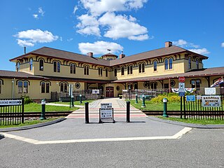
Terryville is a census-designated place (CDP) in Litchfield County, Connecticut, United States, and is the largest village within the town of Plymouth. In the 2010 census, Terryville had a population of 5,387, out of 12,243 in the entire town of Plymouth. The village is named for Eli Terry Jr., the son of the well-known clockmaker Eli Terry Sr. Terryville is also home to the Lock Museum of America. There is a water wheel located in downtown Terryville that is dedicated to the son of Eli Terry Sr.

<span class="mw-page-title-main">Thomaston, Connecticut</span> Town in Connecticut, United States

Thomaston is a town in Litchfield County, Connecticut, United States. The town is part of the Naugatuck Valley Planning Region. The population was 7,442 at the 2020 census. The urban center of the town is the Thomaston census-designated place, with a population of 1,928 at the 2020 census.

<span class="mw-page-title-main">Warren, Connecticut</span> Town in Connecticut, United States

Warren is a town in Litchfield County, Connecticut, United States. The population was 1,351 at the 2020 census. The town is part of the Northwest Hills Planning Region. The town was named for Revolutionary War General Joseph Warren.

<span class="mw-page-title-main">Watertown, Connecticut</span> Town in Connecticut, United States

Watertown is a town in Litchfield County, Connecticut, United States. The town is part of the Naugatuck Valley Planning Region. The population was 22,105 at the 2020 census. The ZIP Codes for Watertown are 06795 and 06779. It is a suburb of Waterbury. The urban center of the town is the Watertown census-designated place, with a population of 3,938 at the 2020 census.

<span class="mw-page-title-main">Winchester, Connecticut</span> Town in Connecticut, United States

Winchester is a town in Litchfield County, Connecticut, United States. The population was 10,224 at the 2020 census. The city of Winsted is located in Winchester. The town is part of the Northwest Hills Planning Region.

<span class="mw-page-title-main">Middlebury, Connecticut</span> Town in Connecticut, United States

Middlebury is a town in New Haven County, Connecticut, United States. The population was 7,574 at the 2020 census. The town is part of the Naugatuck Valley Planning Region.

<span class="mw-page-title-main">Litchfield, Connecticut</span> Town in Connecticut, United States

Litchfield is a town in and former county seat of Litchfield County, Connecticut, United States. The population was 8,192 at the 2020 census. The town is part of the Northwest Hills Planning Region. The boroughs of Bantam and Litchfield are located within the town. There are also three unincorporated villages: East Litchfield, Milton, and Northfield. Northfield, located in the southeastern corner of Litchfield, is home to a high percentage of the Litchfield population.

<span class="mw-page-title-main">Canton Valley, Connecticut</span> Census-designated place in Connecticut, United States

Canton Valley is a village and census-designated place (CDP) in the town of Canton in Hartford County, Connecticut, United States. The population was 1,580 at the 2010 census. As of the 2017 census the population was 1,489.

<span class="mw-page-title-main">New Hartford Center, Connecticut</span> Census-designated place in Connecticut, United States

New Hartford Center is a census-designated place (CDP) in Litchfield County, Connecticut, United States. It comprises the village of New Hartford, the adjacent Pine Meadow Historic District, and some surrounding forest land, all within the town of New Hartford. As of the 2010 census, the population of New Hartford Center was 1,385, out of 6,970 in the entire town of New Hartford.

<span class="mw-page-title-main">Canaan, Connecticut</span> Town in Connecticut, United States

Canaan is a town in Litchfield County, Connecticut, United States. The population was 1,080 at the 2020 census, down from 1,234 at the 2010 census. The town is part of the Northwest Hills Planning Region. The town of Canaan is often referred to locally by the name of its principal settlement, Falls Village.

<span class="mw-page-title-main">Litchfield (borough), Connecticut</span> Borough in Connecticut, United States

Litchfield is a borough in, and the village center of, the town of Litchfield in Litchfield County, Connecticut, United States. The population was 1,258 at the 2010 census. The entire borough was designated a Connecticut historic district in 1959 by special act of the state General Assembly and is listed on the National Register of Historic Places. Part of the borough is also a National Historic Landmark, the Litchfield Historic District.

References

  1. "Census - Geography Profile: Harwinton town, Litchfield County, Connecticut" . Retrieved December 16, 2021.
  2. "Census - Geography Profile: Harwinton town, Litchfield County, Connecticut" . Retrieved December 16, 2021.
  3. The Connecticut Magazine: An Illustrated Monthly. Connecticut Magazine Company. 1903. p. 332.
  4. Gannett, Henry (1905). The Origin of Certain Place Names in the United States. Govt. Print. Off. pp.  151.
  5. "Geographic Identifiers: 2010 Census Summary File 1 (G001), Harwinton town, Litchfield County, Connecticut". American FactFinder. U.S. Census Bureau. Archived from the original on February 13, 2020. Retrieved October 8, 2019.
  6. "Census of Population and Housing". Census.gov. Retrieved June 4, 2015.
  7. "U.S. Census website". United States Census Bureau . Retrieved January 31, 2008.
  8. "Registration and Party Enrollment Statistics as of October 31, 2023" (PDF). Connecticut Secretary of State. Retrieved December 31, 2023.