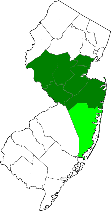
Central Jersey, or Central New Jersey, is the middle region of the U.S. state of New Jersey. The designation Central Jersey is a distinct administrativetoponym.[3][4] While New Jersey is often divided into North Jersey and South Jersey, many residents recognize Central Jersey as a distinct third entity.[5] As of the 2020 census, Central Jersey has a population of 3,580,999.
Many descriptions of Central Jersey include Middlesex County, the population center of New Jersey, and tend to include much of nearby Monmouth, Mercer, Somerset, and Hunterdon counties. The inclusion of adjacent areas of Union and Ocean are a source of debate.[6][7][8] In 2015, New Jersey Business magazine defined Central Jersey more narrowly as the five counties of Hunterdon, Mercer, Middlesex, Monmouth and Somerset.[9]
In 2022, legislation was proposed in the New Jersey Legislature to establish distinct geographic areas for tourism in the state. Bill A4711 was sponsored by Assemblymembers Roy Freiman, Sadaf Jaffer, and Anthony Verrelli in the New Jersey General Assembly.[10] This included an official designation of the region of Central Jersey, which the legislation defines more broadly as the seven counties of Hunterdon, Mercer, Middlesex, Monmouth, Ocean, Somerset, and Union.[11][12] The New Jersey Senate version of this legislation passed by a vote of 36-1 on June 20, 2023.[13] On August 24, 2023, Gov. Murphy signed legislation officially designating Central Jersey including, at a minimum, the counties of Hunterdon, Mercer, Middlesex, and Somerset.[14]
Trenton, the seat of Mercer County and the state capital of New Jersey, is located in the region. New Jersey's geographic center is in Hamilton Township in Mercer County. In 2011, the population center of the state was in the western portion of East Brunswick.[16]
The telephone area codes 732 and 848 includes Middlesex, Monmouth, Somerset, Union, and northern Ocean counties. While area codes 609 and 640 includes southern Ocean, Hunterdon, and Somerset counties, as well as Mercer County.[28]
The since discarded regions of West New Jersey (in yellow) and East New Jersey (in green) that existed from 1674 to 1702 during the colonial era of New Jersey; the map also indicates location of the Keith Line (in red) and the Coxe and Barclay Line (in orange).
Between 1674 and 1702, in the early part of New Jersey's colonial period, the border between West Jersey and East Jersey ran diagonally across the middle part of the state. The Keith Line, as the demarcation is known, ran through the center of what is now Mercer County.[29] This border remained important in determining ownership and political boundaries until 1745. Remnants of that division are seen today, notably as the Hunterdon-Somerset, Ocean-Burlington, and Monmouth-Burlington county lines.[30] The division of the two provinces was cultural as well as geographical.[31]
New Jersey's position between the major cities of New York and Philadelphia led Benjamin Franklin to call the state "a barrel tapped at both ends".[32][33] Travel between the two cities originally included a ferry crossing.
For decades, Central Jersey was a hub for manufacturing in the eastern United States. Many industrial companies had major production facilities in and around the area, including Edison Assembly, Ford Motor Company's production plant for Rangers, Mustangs, Pintos, Mercurys, and Lincolns. Other notable companies include General Motors in Linden, Frigidaire's air-conditioner plant in Edison, Hess Corporation in Woodbridge, Siemens in Edison, and ExxonMobil Chemical.
Starting in the 2000s, manufacturing began to leave Central Jersey, and many facilities had closed and moved overseas.[38][39][40][41]
Depending on the location, different parts of Central Jersey fall into overlapping spheres of influence from New York media market and Philadelphia media market. Mercer County is located in the Philadelphia television market, while the rest of the region belongs wholly to the New York City market.
The Star-Ledger, based in Newark, is the largest circulated newspaper in New Jersey. Four Central Jersey newspapers, Asbury Park Press, Home News Tribune, and two Trenton dailies, The Trentonian and The Times and several local papers are published in Central Jersey. New Jersey On-Line, MyCentralJersey.com and CentralJersey.com[56] are online news services. During statewide political events like Gubernatorial or Senatorial election debates often held in Trenton, partner stations from both the New York and Philadelphia markets pool resources together to co-host the events and bring them to New Jersey homes.
Identification with sports teams is also affected by the region's location, and it is not uncommon to find fans of major sports teams of either city. For example, while residents of northern New Jersey root for New York teams, those in the southern part of the state root for Philadelphia teams.[57][58][59] The distinction is less clear in Central Jersey.[60]Central Jersey Riptide was a short-lived professional soccer club.[61]
Transportation
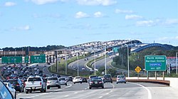
Interstate 195, which travels from the state capital of Trenton to the Jersey Shore, is sometimes referred to as the Central Jersey Expressway.
The Route 9 BBS, the New Brunswick BRT, and the Central Jersey Route 1 Corridor are projects in the region intended to expand the use of bus rapid transit in New Jersey.
Central New Jersey, particularly Edison and surrounding Middlesex County, is prominently known for its significant concentration of Asian Indians. The world's largest Hindu temple was inaugurated in Robbinsville in 2014, a BAPS temple.[65] The growing Little India is a South Asian-focused commercial strip in Middlesex County, the U.S. county with the highest concentration of Asian Indians, at nearly 20% as of 2020.[66][67][68] The Oak Tree Road strip runs for about one-and-a-half miles through Edison and neighboring Iselin in Woodbridge Township, near the area's sprawling Chinatown and Koreatown, running along New Jersey Route 27.[69] It is the largest and most diverse South Asian cultural hub in the United States.[70][71]Monroe Township (nicknamed Edison South), in Middlesex County, has experienced a particularly rapid growth rate in its Indian American population, with an estimated 5,943 (13.6%) as of 2017,[72] which was 23 times the 256 (0.9%) counted as of the 2000 Census; and Diwali is celebrated by the township as a Hindu holiday. Carteret's PunjabiSikh community, variously estimated at upwards of 3,000, constitutes the largest concentration of Sikhs in the state.[73] In Middlesex County, election ballots are printed in English, Spanish, Gujarati, Hindi, and Punjabi.[74]
Indian pharmaceutical and technology companies are coming to Central New Jersey to gain a foothold in the United States. Dr. Reddy's Laboratories, based in Hyderabad, set up its U.S. headquarters in Princeton, Mercer County.[75] Pharmaceutical company Aurobindo, also headquartered in Hyderabad, has established its U.S. headquarters in the Dayton section of South Brunswick, Middlesex County, and has implemented a multimillion-dollar expansion of these Central New Jersey operations.[76] In March 2023, Bengaluru-based technology services and consulting company Wipro opened its American international headquarters in East Brunswick, Middlesex, County.[77]
Starting in the 2000s, highly educated suburbs in northern and central New Jersey, have received a large influx of Taiwanese immigrants. Many Taiwanese American families send their children to Mandarin language schools in Edison. Some of these private schools include Edison Chinese School, located at John Adams Middle School, or Tzu Chi, located at Woodrow Wilson Middle School, both of which teach in Traditional Chinese. The Taiwanese airline China Airlines provides private bus service to John F. Kennedy International Airport from the Kam Man Food location in Edison to feed its flight to Taipei, Taiwan.[80]
Route 27 is a state highway in New Jersey, United States. It runs 38.53 mi (62.01 km) from U.S. Route 206 (US 206) in Princeton, Mercer County northeast to an interchange with Route 21 and Broad Street in Newark, Essex County. The route passes through many communities along the way, including New Brunswick, Highland Park, Edison, Metuchen, Rahway, and Elizabeth. Route 27 is a two- to four-lane undivided highway for most of its length, passing through a variety of urban and suburban environments. It intersects many roads along the way, including Route 18 in New Brunswick, Interstate 287 (I-287) in Edison, the Garden State Parkway in Woodbridge Township, Route 35 in Rahway, Route 28 in Elizabeth, and U.S. Route 22 in Newark. Route 27 crosses the Raritan River on the Albany Street Bridge, which connects Highland Park on the east with New Brunswick on the west.
Middlesex County is located in the north-central part of New Jersey, United States, extending inland from the Raritan Valley region to the northern portion of the Jersey Shore. As of the 2020 United States census, the county was the state's third-most populous county with a population of 863,162, its highest decennial count ever and an increase of 53,304 (+6.6%) from the 2010 census count of 809,858, which in turn reflected an increase of 59,696 (8.0%) from the 750,162 counted in the 2000 census. Middlesex is part of the New York metropolitan area. Many communities within the county serve as commuter towns to and from New York City and other points north. The county is part of the Central Jersey region of the state.
Mercer County is a county located in the U.S. state of New Jersey. Its county seat is Trenton, also the state capital, prompting its nickname The Capital County. Mercer County alone constitutes the Trenton–Princeton metropolitan statistical area and is considered part of the New York combined statistical area by the U.S. Census Bureau, but also directly borders the Philadelphia metropolitan area and is included within the Federal Communications Commission's Philadelphia Designated Media Market Area. The county is part of the Central Jersey region of the state.
Scouting in New Jersey has a long history, from the 1910s to the present day, serving thousands of youth in programs that suit the environment in which they live. The second Boy Scouts of America National Headquarters was in North Brunswick, although it was referred to in BSA publications as being in neighboring New Brunswick.
South Brunswick is a township in Middlesex County, in the U.S. state of New Jersey. The township is centrally located within the Raritan Valley region and is an outer-ring suburb of New York City in the New York metropolitan area. As of the 2020 United States census, the township's population was 47,043, its highest ever decennial census count and an increase of 3,626 (+8.4%) from the 2010 census count of 43,417, which in turn reflected an increase of 5,683 (+15.1%) from the 37,734 counted in the 2000 census.
The Raritan River is a major river of New Jersey. Its watershed drains much of the mountainous area of the central part of the state, emptying into the Raritan Bay on the Atlantic Ocean.
The Delaware and Raritan Canal is a canal in central New Jersey, built in the 1830s, that connects the Delaware River to the Raritan River. It was an efficient and reliable means of transportation of freight between Philadelphia and New York City, transporting anthracite coal from eastern Pennsylvania during much of the 19th and early 20th centuries. The canal allowed shippers to cut many miles off the existing route from the Pennsylvania Coal Region down the Delaware, around Cape May, and up the occasionally treacherous Atlantic Ocean coast to New York City.
The Millstone River is a 38.6-mile-long (62.1 km) tributary of the Raritan River in central New Jersey in the United States.
New Jersey's 12th congressional district is represented by Democrat Bonnie Watson Coleman, who has served in Congress since 2015. The district is known for its research centers and educational institutions such as Princeton University, Rider University, The College of New Jersey, Institute for Advanced Study, Johnson & Johnson and Bristol-Myers Squibb. The district is primarily suburban in character, covering portions of Mercer, Somerset, Union, and Middlesex counties, although the district contains the state capital of Trenton as well as the smaller city of Plainfield.
Central New Jersey Council is a former local Boy Scouts of America council that served the central New Jersey area, spanning across the Counties of Hunterdon, Mercer, Middlesex and Warren.
County Route 527 is a county highway in the U.S. state of New Jersey. The highway extends 84.86 mi (136.57 km) from Main Street in Toms River Township to Pompton Avenue in Cedar Grove. It passes through more counties (six) than any other county route in New Jersey. CR 527 is also the second longest 500-series county route in New Jersey after Route 519. The county route traverses through the northernmost stretches of the Pine Barrens in South Jersey, much of the Raritan Valley and Rahway Valley regions in Central Jersey, and the First and Second Watchung Mountains in North Jersey. It passes through Ocean, Monmouth, Middlesex, Somerset, Union, and Essex counties on the eastern side of the state.
County Route 518 is a county highway in the U.S. state of New Jersey. The highway extends 20.58 miles (33.12 km) from Route 29/Route 165 in Lambertville to Lincoln Highway in Franklin Township. It is also known as the Georgetown Franklin Turnpike.
County Route 514 is a county highway in the U.S. state of New Jersey. The highway extends 42.86 miles (68.98 km) from its western terminus U.S. Route 202 (US 202) and Route 31 in East Amwell Township to its eastern terminus Edgar Road in Elizabeth. West of its western terminus, CR 514 continues as Route 179.
New Jersey has seven metropolitan statistical areas (MSAs) defined by the federal Office of Management and Budget. The New York City and Philadelphia MSAs are also divided into divisions, of which there are five in New Jersey. Every statistical area and county in New Jersey belongs to the Northeast Megalopolis.
Bio-1 is a consortium of partners founded in 2007 designed to identify and promote bioscience in the Central New Jersey area. It is the result of a $5 million grant made available by the Workforce Innovation in Regional Economic Development (WIRED) program.
New Jersey Swimming (NJ) is the Local Swimming Committee (LSC) for competitive swimming in the central and northern New Jersey area. They are a member of USA Swimming and the Eastern Zone. Most of the athletes who compete in NJ-sponsored swim meets are youths under the age of 18.
The Assunpink Trail was a Native American trail in what later became Middlesex, Somerset, and Mercer counties in the central and western part of New Jersey. Like Assunpink Creek, the trail takes its name from the Algonquian language Ahsën'pink, meaning "stony, watery place".
The Old Stone Arch Bridge is a bridge located in Bound Brook, New Jersey, United States. It is the second-oldest extant bridge in the US, after the Frankford Avenue Bridge over Pennypack Creek in North Philadelphia, Pennsylvania. Built in 1731, it is the oldest bridge in New Jersey. It spans the Green Brook and connects Bound Brook with Middlesex Borough in northern central New Jersey.
↑ Jean Mikle (March 31, 2008). "An invisible boundary divides N.J."Home News Tribune. Archived from the original on January 8, 2016. Retrieved January 12, 2010.("Of course, part of the problem with understanding New Jersey's enduring regional tension is that few residents can agree on where the northern half of the state ends and the southern half begins.")
↑ Saliba, George N. "Central New Jersey’s Success The low-down on economic developments within this five-county region.", New Jersey Business, March 16, 2015. Accessed December 4, 2019. "While New Jersey’s onerous tax structure and an uncertain economic climate have often been headline news, perhaps unsung is the fact that portions of the Garden State are steadily thriving, including much of Central New Jersey, which is comprised of: Somerset County, Monmouth County, Mercer County, Hunterdon County and Middlesex County."
↑ New Jersey Legislature. Bill A4711 Session 2022 - 2023], New Jersey Legislature, introduced October 11, 2022. Accessed February 18, 2023. "The Division of Travel and Tourism shall re-draw the State tourism map to create a 'Central Jersey' region comprised, at a minimum of the counties of Hunterdon, Mercer, Middlesex, and Somerset, and to incorporate the 'Central Jersey' region in all regional marketing activities, including in publications and on the VisitNJ.org website."
↑ Stirling, Stephen (March 31, 2011). "U.S. Census shows East Brunswick as statistical center of N.J."The Star-Ledger. Retrieved November 7, 2012. if all 8.8 million residents of the state were to stand on a giant table supported by a single leg, Nenninger Lane would be the fulcrum point keeping it balanced
↑ Fairall, Herbert (1885). The World's Industrial and Cotton Centennial Exposition, New Orleans, 1884-1885. p. 225. Google Book Search. Retrieved on December 4, 2009. "Dr. Benjamin Franklin once perpetrated the witticism 'that New Jersey was like a beer barrel tapped at both ends, with all the live beer running into Philadelphia and New York.'"
↑ Soderlund, Jean R. (October 15, 1996). Wacker, Peter O.; Clemens, Paul G. E. (eds.). ""A Barrel Tapped at Both Ends": New Jersey and Economic Development". Reviews in American History. 24 (4): 574–578. doi:10.1353/rah.1996.0107. JSTOR30030707. S2CID143847945.
↑ A wet day in the Hub City, Home News Tribune, September 23, 1999. "A few days short of 60 years, on Wednesday, Sept. 16, a dreary, drizzly day just ahead of the deluge of Hurricane Floyd, the Home News Tribune sent 24 reporters, 9 photographers and one artist into the Hub City, as it is known, to take a peek into life in New Brunswick as it is in 1999."
↑ "Excerpt from New Book: The Medical Science of House, M.D. Holtz, Andrew". Oncology Times. 28 (20): 50–52, 54–55, 58. October 25, 2006. doi:10.1097/01.COT.0000295295.97642.ae.
↑ Reiss, Fraidy. "Feeling adventurous?", Asbury Park Press, March 31, 2007, accessed April 18, 2007. "Elsewhere in the park, Kingda Ka looms 456 feet high. It remains the tallest and fastest roller coaster in the world, said park president Kane."
↑ . American Revolution Destinations in Central & Southern New Jersey. Accessed January 17, 2022.
↑ . New Jersey and the Revolution. Accessed January 17, 2022.
↑ Staff. "Patriotic Reading Again Saves Site", The New York Times, July 4, 1970. "Middlebrook Heights, N.J., July 3 (UPI) A reading of the Declaration of Independence tomorrow will preserve for another year the historic campsite here where George Washington is believed to have first flown the 13-star flag officially before his troops."
↑ Stephen Stirling (August 3, 2017). "10 ways Lakewood is unlike anywhere else in N.J." NJ Advance Media. Retrieved April 19, 2019. The sea change can be pinned to one event: The founding of the Beth Medrash Govoha yeshiva in the mid-20th century. The Orthodox Jewish community has set down roots en masse around the religious school, which is now the largest yeshiva in North America.
This page is based on this Wikipedia article Text is available under the CC BY-SA 4.0 license; additional terms may apply. Images, videos and audio are available under their respective licenses.