Dutchess County, New York

Last updated

Dutchess County
Main Mall Row, Poughkeepsie, NY.jpg
Main Mall Row, Poughkeepsie
Flag of Dutchess County, New York.png
Seal of Dutchess County, New York.png
Map of New York highlighting Dutchess County.svg
Location within the U.S. state of New York
New York in United States.svg
New York's location within the U.S.
Coordinates: 41°46′N73°45′W / 41.76°N 73.75°W / 41.76; -73.75
CountryFlag of the United States.svg United States
StateFlag of New York.svg  New York
FoundedNovember 1, 1683;340 years ago (1683-11-01) [upper-alpha 1] [upper-alpha 2]
Named for Mary of Modena, Duchess of York
Seat Poughkeepsie
Largest cityPoughkeepsie
Government
  Executive Sue Serino (R)
Area
  Total825 sq mi (2,140 km2)
  Land796 sq mi (2,060 km2)
  Water30 sq mi (80 km2)
Population
 (2020)
  Total295,911 [3]
  Estimate 
(2021)
297,112
Time zone UTC−5 (Eastern)
  Summer (DST) UTC−4 (EDT)
Area code 845, 518, 838
Congressional districts 17th, 18th
Website www.co.dutchess.ny.us

Dutchess County is a county in the U.S. state of New York. As of the 2020 census, the population was 295,911. [4] The county seat is the city of Poughkeepsie. [5] The county was created in 1683, one of New York's first twelve counties, [upper-alpha 1] and later organized in 1713. [upper-alpha 2] [6] The county is part of the Hudson Valley region of the state.

Contents

Dutchess County is part of the Kiryas Joel-Poughkeepsie-Newburgh Metropolitan Statistical Area, [7] which belongs to the larger New York–Newark–Bridgeport, NY-NJ-CT-PA Combined Statistical Area.

History

View of Harlem Valley from Appalachian Trail in Pawling Harlem Valley view from Appalachian Trail, Pawling, NY.jpg
View of Harlem Valley from Appalachian Trail in Pawling

Before Anglo-Dutch settlement, what is today Dutchess County was a leading center for the indigenous Wappinger peoples. They had their council-fire at what is now Fishkill Hook, [8] and had settlements throughout the area.

On November 1, 1683, the Province of New York established its first twelve counties, including Dutchess. [upper-alpha 1] Its boundaries at that time included the present Putnam County, and a small portion of the present Columbia County (the towns of Clermont and Germantown). The county was named for Mary of Modena, Duchess of York; dutchess is an archaic spelling of the word duchess . [9] [10]

A 1799 map of Connecticut which shows The Oblong (Low's Encyclopaedia) LowsCTmap.jpeg
A 1799 map of Connecticut which shows The Oblong ( Low's Encyclopaedia )

The Province of New York and the Connecticut Colony negotiated an agreement on November 28, 1683, establishing their border as 20 miles (32 km) east of the Hudson River, north to Massachusetts. The 61,660 acres (249.5 km2) east of the Byram River making up the Connecticut Panhandle were granted to Connecticut, in recognition of the wishes of the residents. In exchange, Rye was granted to New York, along with a 1.81-mile (2.91 km) wide strip of land running north from Ridgefield to Massachusetts alongside the New York counties of Westchester, Putnam then Dutchess, known as "The Oblong". The eastern half of the stub of land in northeast Dutchess County containing Rudd Pond and Taconic State Park is the northernmost extension of The Oblong. [11]

Until 1713, Dutchess was administered by Ulster County. On October 23, 1713, Queen Anne gave permission for Dutchess County to elect its own officers from among their own population, including a supervisor, tax collector, tax assessor and treasurer. In 2013, Dutchess County celebrated its 300th anniversary of democracy based upon a legislative resolution sponsored by County Legislator Michael Kelsey from Salt Point. In 1812, Putnam County was detached from Dutchess. [12]

The Patents

Map of Philipse Patent (showing the Oblong and Gore) Map of Philipse Patent (showing the Oblong and Gore).png
Map of Philipse Patent (showing the Oblong and Gore)

Fourteen royal land patents were granted between 1685 and 1706 covering the entirety of the original footprint of Dutchess County (which until 1812 included today's Putnam County).

The first ten, granted between 1685 and 1697, covered almost all of Hudson River shoreline in the original county, with three - Rombouts, the Great Nine Partners, and Philipse Patents - extending significantly inland. The eleventh, and smallest, Cuyler, 1697, was the first to contain solely inland territory, just in from the Hudson. The twelfth, and next smallest, Fauconnier, in 1705, completed the Hudson River shoreline. The last two, Beekman, 1705, and the Little Nine Partners, 1706, laid claim to the remaining interior lands.

  1. 1685 Rombout (Beacon/Fishkill Area)
  2. 1686 Minnisinck (Sanders & Harmense)
  3. 1686 Kip
  4. 1688 Schuyler (Poughkeepsie)
  5. 1688 Schuyler (Red Hook)
  6. 1688 Ærtsen-Roosa-Elton
  7. 1696 Pawling-Staats
  8. 1697 Rhinebeck
  9. 1697 (Great) Nine Partners
  10. 1697 Philipse
  11. 1697 Cuyler
  12. 1705 Fauconnier
  13. 1705 Beekman (Back Lots)
  14. 1706 (Little) Nine Partners

Early settlement

From 1683 to 1715, most of the settlers in Dutchess County were Dutch. Many of these moved in from Albany and Ulster counties. They settled along the Fishkill Creek and in the areas that are now Poughkeepsie and Rhinebeck. [13]

From 1715 to 1730, most of the new settlers in Dutchess county were Germans. From 1730 until 1775, New Englanders were the primary new settlers in Dutchess County. [14] Coles Mills was settled by Elisha Cole from Cape Cod in 1747 at the outlet of Barrett Pond into the West Branch of the Croton River. [15]

20th century

Franklin D. Roosevelt lived in his family home in Hyde Park, overlooking the Hudson River. His family's home is now the Home of Franklin D. Roosevelt National Historic Site, managed by the National Park Service.

Prior to the 1960s, Dutchess County was primarily agricultural. Since then the southwestern part (from Poughkeepsie southward and from the Taconic State Parkway westward) of the county has developed into a largely residential area, suburban in character, with many of its residents commuting to jobs in New York City and Westchester County. The northern and eastern regions of the county remain rural with large farmlands but at the same time developed residences used during the summer and or on weekends by people living in the New York City urban area. [16]

Geography

According to the U.S. Census Bureau, the county has a total area of 825 square miles (2,140 km2), of which 796 square miles (2,060 km2) is land and 30 square miles (78 km2) (3.6%) is water. [17]

Dutchess County is located in southeastern New York State, between the Hudson River on its west and the New YorkConnecticut border on its east, about halfway between the cities of Albany and New York City. It contains two cities: Beacon and Poughkeepsie. Depending on precise location within the county, road travel distance to New York City ranges between 58 and 110 miles (93 and 177 km).

The terrain of the county is mostly hilly, especially in the Hudson Highlands in the southwestern corner and the Taconic Mountains to the northeast. Some areas nearer the river are flatter.

Summit of Brace Mountain, the highest point in Dutchess County Brace Mountain summit cairn.jpg
Summit of Brace Mountain, the highest point in Dutchess County

The highest point in the county is the summit of Brace Mountain, in the Taconics, at 2,311 feet (704 m) above sea level. The lowest point is sea level, along the Hudson River. The highest point of neighboring Fairfield County, Connecticut, is a 1,290-foot (390 m) point along the state line in Pawling.

Wappinger Creek, at 41.7 mi (67.1 km) from its source at Thompson Pond in Pine Plains to where it drains into the Hudson at New Hamburg, is the longest stream in the county. Its 211-square-mile (550 km2) watershed is likewise the largest in the county. To its south is the 193-square-mile (500 km2) watershed of Dutchess County's second-longest stream, 33.5 mi (53.9 km) Fishkill Creek, part of which spills over into Putnam County. Within that watershed are the county's third-longest stream, Sprout Creek, and its largest, deepest and highest lakes: Whaley (252 acres (102 ha)), in the town of Pawling; Sylvan (143 ft (44 m)) in the town of Beekman and Beacon Reservoir, in the town of Fishkill, at 1,285 ft (392 m) respectively.

Other, smaller tributaries of the Hudson such as the Saw Kill drain the northwestern portion of the county. The southeastern fringe of Dutchess is part of the upper Croton River watershed and thus part of the New York City water supply system. On the east, in the Oblong, streams drain into the Housatonic River in adjacent Connecticut.

A border nearly one-half mile (800 m) long exists with Berkshire County, Massachusetts, in the extreme northern end of the county.

Adjacent counties

National protected areas

State, county, and town parks

Privately protected open space

Demographics

Historical population
CensusPop.Note
1790 45,276
1800 47,7755.5%
1810 51,3637.5%
1820 46,615−9.2%
1830 50,9269.2%
1840 52,3982.9%
1850 58,99212.6%
1860 64,94110.1%
1870 74,04114.0%
1880 79,1846.9%
1890 77,879−1.6%
1900 81,6704.9%
1910 87,6617.3%
1920 91,7474.7%
1930 105,46214.9%
1940 120,54214.3%
1950 136,78113.5%
1960 176,00828.7%
1970 222,29526.3%
1980 245,05510.2%
1990 259,4625.9%
2000 280,1508.0%
2010 297,4886.2%
2020 295,911−0.5%
2021 (est.)297,1120.4%
U.S. Decennial Census [18]
1790–1960 [19] 1900–1990 [20]
1990–2000 [21] 2010–2020 [4]

2020 census

Dutchess County Racial Composition [22]
RaceNum.Perc.
White (NH)198,49567.1%
Black or African American (NH)30,12610.2%
Native American (NH)3870.13%
Asian (NH)10,6353.6%
Pacific Islander (NH)670.02%
Other/Mixed (NH)13,9774.72%
Hispanic or Latino 42,22414.7%

2000 census

As of the census [23] of 2000, there were 280,150 people, 99,536 households, and 69,177 families residing in the county. The population density was 350 inhabitants per square mile (140/km2). There were 106,103 housing units at an average density of 132 units per square mile (51/km2). 22.0% of the population was of Italian, 16.9% Irish, 11.3% German and 6.7% English ancestry according to Census 2000. 88.3% spoke English and 4.8% spoke Spanish.

Based on the Census Ancestry tallies, including people who listed more than one ancestry, Italians were the largest group in Dutchess County with 60,645. Irish came in a very close second at 59,991. In third place were the 44,915 Germans who barely exceeded the 44,078 people not in the 105 specifically delineated ancestry groups. [24]

There were 99,536 households, out of which 34.5% had children under the age of 18 living with them, 55.5% were married couples living together, 10.3% had a female householder with no husband present, and 30.5% were non-families. 24.6% of all households were made up of individuals, and 9.0% had someone living alone who was 65 years of age or older. The average household size was 2.63 and the average family size was 3.16.

As of Q4 2021, the median home value in Dutchess County was $365,199, an increase of 13.8% from the prior year. [25]

In the county, the age distribution of the population shows 25.1% under the age of 18, 9.4% from 18 to 24, 30.2% from 25 to 44, 23.2% from 45 to 64, and 12.0% who were 65 years of age or older. The median age was 37 years. For every 100 females, there were 100.1 males. For every 100 females age 18 and over, there were 98.2 males.

The median income for a household in the county was $53,086, and the median income for a family was $63,254. Males had a median income of $45,576 versus $30,706 for females. The per capita income for the county was $23,940. About 5.0% of families and 7.5% of the population were below the poverty line, including 8.5% of those under age 18 and 6.5% of those age 65 or over.

The decrease in population between 1810 and 1820 was due to the separation of Putnam County from Dutchess in 1812.

Racial demographics

As of 2017, the residents of Dutchess County were reported as the following: American Indian and Alaska Native (0.04%), Asian (4%), Black or African American (8.5%), Hispanic or Latino (12.5%), Native Hawaiian and Other Pacific Islander (0.016%), Some Other Race (0.35%), Two or More Races (3%), White (71%). [26]

Dutchess County Racial Demographics Chart Dutchess County Racial Demographics Chart.jpg
Dutchess County Racial Demographics Chart

Government

The current Dutchess County Court House, built in 1903, stands on the same site as the original 1720 building Dutchess County Courthouse.jpg
The current Dutchess County Court House, built in 1903, stands on the same site as the original 1720 building

Dutchess County has a Charter Government with a County Executive and directly elected legislature of 25 members, each elected from a single member district. [27] The Charter form of Government went in to effect in 1968 given the favorable outcome of a 1967 special election dedicated to the question. [28] From 1713 until 1967, the County Government had been managed by a Board of Supervisors, made up of the locally elected leaders. [29]

Dutchess County Executives
NamePartyTerm
David C. Schoentag Republican January 1, 1968 – December 31, 1971
Edward C. Scheuler Republican January 1, 1976 – April 29, 1978
James D. Benson Republican April 29, 1978 – December 31, 1978
Lucille P. Pattison Democratic January 1, 1979 – December 31, 1991
William R. Steinhaus Republican January 1, 1992 – December 31, 2011
Marcus J. MolinaroRepublicanJanuary 1, 2012 – January 2, 2023
William F.X. O'NeilRepublicanJanuary 3, 2023 – December 31, 2023
Sue SerinoRepublicanJanuary 1, 2024 – Present
Dutchess County Legislature (2024–2025) [30]
DistrictLegislatorTitlePartyResidence
1Bob GormanRepublican Poughkeepsie
2Ryan TravelpieceRepublican Pleasant Valley
3Michael PolasekAssistant Majority LeaderRepublican Poughkeepsie
4Brendan LawlerDemocratic Hyde Park
5Tony D’AquanniRepublicanPoughkeepsie
6Lisa R. KaulDemocraticPoughkeepsie
7Will TruittChairmanRepublicanHyde Park
8Craig P. BrendliDemocratic Poughkeepsie
9Barrington R. AtkinsAssistant Minority LeaderDemocraticPoughkeepsie
10Randy JohnsonDemocraticPoughkeepsie
11Brennan KearneyDemocratic Rhinebeck
12John D. MetzgerRepublican Hopewell Junction
13Lisa PaoloniRepublicanWappingers Falls
14Lynne VersaciRepublican Wappingers Falls
15Robert S. FaustRepublicanWappingers Falls
16Yvette Valdés SmithMinority LeaderDemocratic Beacon
17Doug McHoulRepublican Fishkill
18Nick PageDemocraticBeacon
19Chris DragoDemocratic Stanfordville
20Kristofer MunnDemocratic Red Hook
21Stephen M. CaswellRepublicanStormville
22Faye GaritoRepublicanPoughquag
23Chris RolisonRepublican Hopewell Junction
24Andrew J. HouseRepublicanDover Plains
25Deirdre A. HoustonMajority LeaderRepublican Millbrook

Elections

United States presidential election results for Dutchess County, New York [31]
Year Republican Democratic Third party
No.%No.%No.%
2020 66,87244.25%81,44353.89%2,8071.86%
2016 61,82147.19%62,28547.54%6,9125.28%
2012 56,02545.29%65,31252.80%2,3681.91%
2008 59,62845.07%71,06053.71%1,6141.22%
2004 63,37251.16%58,23247.01%2,2771.84%
2000 52,66947.12%52,39046.87%6,7126.01%
1996 41,92940.39%47,33945.60%14,55314.02%
1992 46,70940.50%41,65536.12%26,96423.38%
1988 62,16560.97%38,96838.22%8260.81%
1984 70,32467.89%32,86731.73%3890.38%
1980 53,61657.65%28,61630.77%10,77511.59%
1976 51,31256.94%37,53141.65%1,2681.41%
1972 64,86469.82%27,87230.00%1670.18%
1968 45,03254.87%31,02537.80%6,0107.32%
1964 29,50337.01%50,17962.94%430.05%
1960 46,10960.67%29,84239.26%530.07%
1956 53,84078.35%14,87621.65%00.00%
1952 46,38171.17%18,64428.61%1420.22%
1948 34,06764.23%17,43932.88%1,5332.89%
1944 32,89058.92%22,77840.80%1580.28%
1940 32,32955.69%25,59844.10%1220.21%
1936 28,86853.12%24,46745.02%1,0101.86%
1932 25,75754.95%20,37443.47%7401.58%
1928 28,68761.30%16,74835.79%1,3662.92%
1924 22,17364.64%8,86425.84%3,2669.52%
1920 21,15265.60%9,93830.82%1,1563.58%
1916 11,08254.60%8,90643.88%3101.53%
1912 8,91643.65%8,87143.43%2,63812.92%
1908 11,13253.58%8,96143.13%6823.28%
1904 11,70957.06%8,27540.32%5372.62%
1900 11,93659.39%7,69138.27%4712.34%
1896 12,12762.44%6,63434.16%6613.40%
1892 9,37648.09%8,97846.05%1,1415.85%
1888 10,26550.95%9,24945.91%6343.15%
1884 9,70151.13%8,67745.73%5963.14%

The composition of the County Legislature is 15 Republicans and 10 Democrats for the 2024–2025 term. County elections occur in odd-numbered years. [32]

Historically, Dutchess County, like most of the lower Hudson, was classic "Yankee Republican" territory. Between 1884 and 2004, the Republican presidential candidate carried Dutchess County in 28 out of 30 elections (1964 and 1996 being exceptions). Even Hyde Park resident Franklin D. Roosevelt failed to carry the county during his four campaigns.

The Republican edge narrowed significantly in the 1990s, with George H. W. Bush going from 61 percent of the county's vote in 1988 to only 40.5 percent in 1992, although that likely was affected by the presence of Ross Perot on the ballot as a third-party candidate. In 2008, Barack Obama became only the third Democrat to carry the county since 1884, and the first to win a majority since Lyndon Johnson in 1964. It has gone for the Democratic candidate in four consecutive elections (2008, 2012, 2016, and 2020).

Dutchess County is split between two congressional districts. The most southern portion is in the 17th district, represented by Republican Mike Lawler. The rest of the county is in the 18th district, represented by Democrat Pat Ryan. These are considered "swing" districts nationally, with Cook Partisan Voting Index ratings of D+3 and D+1, respectively, as of 2022.

Law enforcement

The Cities of Beacon and Poughkeepsie; Towns of Fishkill, Hyde Park, Pine Plains, Poughkeepsie, Rhinebeck, Red Hook, and East Fishkill; and Villages of Millerton, Wappingers Falls, Millbrook, have their own Police departments. The remainder of the county is patrolled by the Dutchess County Sheriff's Office and New York State Police. The New York State Police Troop K headquarters is located in Millbrook.

Communities

N.B.: Cities, Towns and Villages are official political designations.

Dutchess County, New York

Cities

Towns

Villages

Census-designated places

Hamlets

Education

Public school districts

Private schools

Higher education

Transportation

Roads

The Taconic Parkway in southern Dutchess County Taconic State Parkway view at Miller Hill Road exit, East Fishkill, NY.jpg
The Taconic Parkway in southern Dutchess County

Crossings

Newburgh-Beacon Bridge Newburgh-Beacon Bridge 2.jpg
Newburgh-Beacon Bridge

Three spans cross the Hudson River, linking Dutchess with Orange, Ulster, and Greene Counties:

Railroads

Harlem Valley-Wingdale station, along Harlem line Harlem Valley-Wingdale station from grade crossing.jpg
Harlem Valley-Wingdale station, along Harlem line

The Metro-North railroad provides a critical link to New York City for Dutchess County's commuting population. The Hudson Line and Amtrak run concurrently along the Hudson River, on the western edge of the county. The Hudson Line has stops at Breakneck Ridge, Beacon, and New Hamburg (a hamlet of the town of Poughkeepsie) before the Hudson Line terminates at Poughkeepsie. The tracks continue north of that point as Amtrak, with Poughkeepsie and Rhinecliff (a small hamlet in the Town of Rhinebeck) being stops along Amtrak's Empire Service.

The Harlem Line, on the eastern side of the county, has station stops in Pawling, along the Appalachian Trail, Wingdale, Dover Plains, and two stops in Wassaic (one along the Tenmile River and the other the namesake terminus of that line).

Buses and ferries

LOOP bus in Poughkeepsie Dutchess LOOP Orion 210.jpg
LOOP bus in Poughkeepsie

Public transportation in Dutchess County is handled by Dutchess County Public Transit, commonly called "the LOOP." Outside of the urbanized area of the county, most service is limited. Privately run lines connect Poughkeepsie to New Paltz and Beacon to Newburgh. Leprechaun Lines and Short Line Bus also operate some service through Poughkeepsie, Rhinebeck, and the southern part of the county.

NY Waterway operates the Newburgh–Beacon Ferry, which is located at the Beacon train station.

Air

General aviation facilities are located at Hudson Valley Regional Airport (formerly Dutchess County Airport), located in Wappinger and Sky Park Airport in Red Hook, New York. [34] General commercial passenger service is provided by New York Stewart International Airport, which is located across the Hudson River in Newburgh.

The Mid-Hudson Bridge, a major bridge in Poughkeepsie Mid-Hudson Bridge night NY1.jpg
The Mid-Hudson Bridge, a major bridge in Poughkeepsie

Culture

The Dutchess County Fair is an annual event Fun at the Dutchess County Fair August 21, 2012.jpg
The Dutchess County Fair is an annual event

Dutchess County holds an annual county fair. The County Chamber of Commerce holds an annual hot air balloon launch typically in the first week of July. The main launch sites are along the Hudson River. As many as 20 balloons participate in the event.

The Dutchess County Historical Society was formed in 1914 and is active in the preservation of a large collection at the 18th century Clinton House. The Society has published a yearbook since 1914 and presents up to four awards of merit in the field of Dutchess County history each year.

Media

Dutchess County has no locally based television stations. Its only news radio format station is WKIP (AM) of Poughkeepsie. WRHV is an NPR affiliated broadcasting out of Poughkeepsie. The country music format station, WRWB-FM, broadcasting across the Hudson River, can be reached in much of the county.

Poughkeepsie Journal is published in that city. Vassar Miscellany News, associated with Vassar College, is published weekly. Also published in the county is the Beacon Free Press/Southern Dutchess News.

Health

The county is home to Northern Dutchess Hospital in Rhinebeck. MidHudson Regional Hospital (formerly St. Francis) and Vassar Brothers Medical Center are both in Poughkeepsie. The Castle Point Veterans Health Administration is in Wappinger.

On March 11, 2020, the county's first case of COVID-19 was confirmed. As of June 2021, there had been 29,483 cases and 445 deaths. There are under 100 active cases and 56.8% of residents received at least one vaccine dose. [35]

Sports

The Hudson Valley Renegades are a minor league baseball team affiliated with the New York Yankees. The team is a member of the High-A East, and play at Dutchess Stadium in Fishkill.

The Hudson Valley Bears were one of four founding members of the Eastern Professional Hockey League (EPHL). They played their home games at the Mid-Hudson Civic Center in Poughkeepsie.

The Hudson Valley Hawks was a team in the former National Professional Basketball League. The team's home court was at Beacon High School, in Beacon.

See also

Notes

  1. 1 2 3 "When, in 1682, Colonel Thomas Dongan was appointed Governor of the Province of New York, he was instructed to form a council of not more than ten of the 'most eminent Inhabitants' who were to assist him in the making of 'fit' laws. One of the first acts authorized by this council was the erection of twelve 'countyes,' on which Dutchess was one (November 1, 1683)." [1]
  2. 1 2 "There were too few inhabitants of Dutchess at its erection for it to be represented separately in the General Assembly, so that it was provisionally attached to Ulster until 1713." [2]

Related Research Articles

<span class="mw-page-title-main">Putnam County, New York</span> County in New York, United States

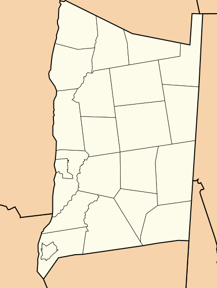
Putnam County is a county located in the U.S. state of New York. As of the 2020 census, the population was 97,668. The county seat is Carmel, located within one of six towns comprising the county. The county is part of the Hudson Valley region of the state.

<span class="mw-page-title-main">Beacon, New York</span> City in New York, United States

Beacon is a city located on the Hudson River in Dutchess County, New York, United States. As of the 2020 census, the city's population was 13,769. Beacon is part of the Kiryas Joel–Poughkeepsie–Newburgh Metropolitan Statistical Area as well as the larger New York–Newark–Bridgeport, New York–New Jersey–Connecticut–Pennsylvania Combined Statistical Area.

<span class="mw-page-title-main">Beekman, New York</span> Town in New York, United States

Beekman is a town in Dutchess County, New York, United States. It is part of the Kiryas Joel-Poughkeepsie–Newburgh, NY Metropolitan Statistical Area as well as the larger New York–Newark–Bridgeport, NY-NJ-CT-PA Combined Statistical Area. The population was 14,172 at the 2020 census. The town was named after Henry Beekman, a 17th-century land owner.

<span class="mw-page-title-main">East Fishkill, New York</span> Town in New York, United States

East Fishkill is a town on the southern border of Dutchess County, New York, United States. The population was 29,707 at the 2020 census. Until its creation in 1849, the town was the eastern portion of the town of Fishkill.

<span class="mw-page-title-main">LaGrange, New York</span> Town in New York, United States

LaGrange is a town in Dutchess County, New York, United States. The population was 15,975 at the 2020 census. The town was named after the estate of the Marquis de Lafayette.

<span class="mw-page-title-main">Wappinger, New York</span> Town in New York, United States

Wappinger is a town in Dutchess County, New York, United States. The town is located in the Hudson River Valley region, on the eastern bank of the Hudson River. The population was 28,216 at the 2020 census. The name is derived from the Wappinger Native Americans who inhabited the area. Wappinger comprises three-fourths of the incorporated village of Wappingers Falls, several unincorporated hamlets such as Chelsea, Diddell, Hughsonville, Middlebush, Myers Corners, New Hackensack, and Swartwoutville, and a number of neighborhoods.

<span class="mw-page-title-main">Wappingers Falls, New York</span> Village in New York, United States

Wappingers Falls is a village in the towns of Poughkeepsie and Wappinger, in Dutchess County, New York, United States. As of the 2010 census it had a population of 5,522. The community was named for the cascade in Wappinger Creek. The Wappingers Falls post office covers areas in the towns of Wappinger, Poughkeepsie, Fishkill, East Fishkill, and LaGrange. This can result in some confusion when residents of the outlying towns, who do not live in the village, give their address as "Wappingers Falls".

<span class="mw-page-title-main">Fishkill, New York</span> Village in New York, United States

Fishkill is a village within the town of Fishkill in Dutchess County, New York, United States. The village is in the eastern part of the town of Fishkill on U.S. Route 9. It is north of Interstate 84. NY 52 is the main street. It is part of the Poughkeepsie–Newburgh–Middletown, NY Metropolitan Statistical Area as well as the larger New York–Newark–Bridgeport, NY-NJ-CT-PA Combined Statistical Area. The first U. S. Post Office in New York state was established in Fishkill by Samuel Loudon, its first Postmaster.

<span class="mw-page-title-main">Fishkill (town), New York</span> Town in New York, United States

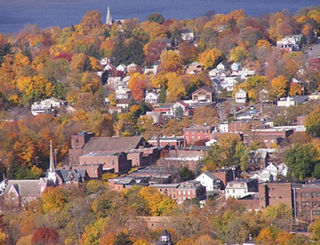
Fishkill is a town in the southwestern part of Dutchess County, New York, United States. It lies approximately 60 miles (97 km) north of New York City. The population was 24,226 at the 2010 census. Fishkill surrounds the city of Beacon, and contains a village, which is also named Fishkill.

<span class="mw-page-title-main">New York State Route 199</span> New York state highway in Ulster and Dutchess counties

New York State Route 199 is a 30.91-mile-long (49.74 km) state highway located in the Hudson Valley of the U.S. state of New York. Its western end is in Ulster County, where it begins as the continuation of the short U.S. Route 209 freeway east of its interchange with U.S. Route 9W; after crossing the Kingston–Rhinecliff Bridge over the Hudson River the rest of the highway crosses northern Dutchess County. As it does it passes through downtown Red Hook and Pine Plains, reaching its eastern end at U.S. Route 44 and State Route 22 southwest of Millerton in the upper Harlem Valley.

<span class="mw-page-title-main">Newburgh, Dutchess and Connecticut Railroad</span> Railway line in New York, US

The Newburgh, Dutchess and Connecticut Railroad was a railroad in Dutchess County, New York, United States. Its line ran 58.9 miles (94.8 km) northeast from the Hudson River in Fishkill to the Connecticut state line near Millerton. The Dutchess and Columbia Railroad (D&C), was chartered in 1866 to link rural villages with the Hudson River Railroad and New York and Harlem Railroad. The under-construction line was leased by the Boston, Hartford and Erie Railroad (BH&E) in 1868. The first segment opened in July 1869, and it reached Pine Plains the following February.

<span class="mw-page-title-main">New York State Route 9D</span> State highway in New York, United States

New York State Route 9D (NY 9D) is a north–south state highway in the Hudson Valley region of New York in the United States. It starts at the eastern end of the Bear Mountain Bridge at an intersection with U.S. Route 6 (US 6) and US 202 in Westchester County, and follows the eastern shore of the Hudson River for 25.21 miles (40.57 km) to a junction with US 9 north of the village of Wappingers Falls in Dutchess County. While US 9 follows a more inland routing between the bridge and Wappingers Falls, the riverside course of NY 9D takes the route through the village of Cold Spring and the city of Beacon.

<span class="mw-page-title-main">Area codes 845 and 329</span> Telephone area code in New York state

Area codes 845 and 329 are telephone area codes in the North American Numbering Plan (NANP) for the U.S. state of New York. The numbering plan area comprises the mid- and lower Hudson Valley, specifically Orange, Putnam, Rockland, and Ulster counties, and parts of Columbia, Delaware, Dutchess, Greene, and Sullivan counties.

<span class="mw-page-title-main">New York State Route 82</span> State highway in New York, US

New York State Route 82 (NY 82) is a state highway in the eastern Hudson Valley of New York in the United States. It begins at an junction with NY 52 northeast of the village of Fishkill, bends eastward towards Millbrook, and then returns westward to end at a junction with U.S. Route 9, NY 9H, and NY 23 at Bell Pond, near Claverack. NY 82 meets the Taconic State Parkway twice; it is the only state highway that has more than one exit with the parkway. The road spans two counties: Dutchess and Columbia.

<span class="mw-page-title-main">Fishkill Creek</span> Tributary of the Hudson River in southern Dutchess County, New York

Fishkill Creek is a tributary of the Hudson River in Dutchess County, New York, United States. At 33.5 miles (53.9 km) it is the second longest stream in the county, after Wappinger Creek. It rises in the town of Union Vale and flows generally southwest to a small estuary on the Hudson just south of Beacon. Part of its 193-square-mile (500 km2) watershed is in Putnam County to the south. Sprout Creek, the county's third-longest creek, is its most significant tributary. Whaley and Sylvan lakes and Beacon Reservoir, its largest, deepest and highest lakes, are among the bodies of water within the watershed.

<span class="mw-page-title-main">TEG Federal Credit Union</span>

TEG Federal Credit Union is a federally chartered credit union in the New York counties of Dutchess, Orange, Westchester, Putnam, Rockland, Sullivan, and Ulster. As of 2020, the institution has $305 million in assets, 118 employees, and 36,000 members.

<span class="mw-page-title-main">Chelsea, Dutchess County, New York</span> Hamlet in New York, United States

Chelsea is a hamlet of the Town of Wappinger in Dutchess County, New York, United States. It is located on the Hudson River in the southwestern corner of the town. It takes the ZIP Code 12512 and is in the 845 telephone area code, and has its own fire district.

<span class="mw-page-title-main">Kiryas Joel-Poughkeepsie-Newburgh metropolitan area</span> Metropolitan statistical area in New York, United States

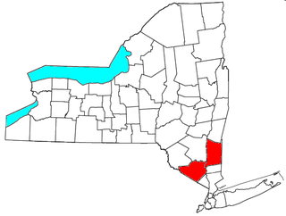
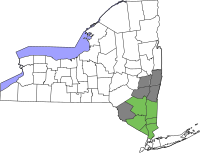
The Kiryas Joel-Poughkeepsie-Newburgh, NY Metropolitan Statistical Area, as defined by the United States Office of Management and Budget, is an area consisting of two counties in New York's Hudson Valley, with the municipalities of Kiryas Joel, Poughkeepsie, and Newburgh as its principal cities. As of the 2020 census, the MSA had a population of 679,221. The area was centered on the urban area of Poughkeepsie-Newburgh. Prior to July 2023, it was known as the Poughkeepsie-Newburgh-Middletown, NY Metropolitan Statistical Area; whereupon it was renamed to its current name, to reflect population changes among its largest municipalities.

<span class="mw-page-title-main">Old St. Peter's Church (Poughkeepsie, New York)</span> Building in New York, United States

The Old Church of St. Peter is a Roman Catholic church established under the authority of the Roman Catholic Archdiocese of New York in Poughkeepsie, Dutchess County, New York in 1837. It is the second oldest Catholic Church on the Hudson and is considered the Mother Church of the Hudson Valley because from it all the parishes in Ulster and Dutchess counties were founded. The church is also referred to as Our Lady of Mount Carmel since 1965 when St. Peter's parish relocated to Hyde Park, New York and the parish of Our Lady of Mount Carmel church relocated to site.

Wappingers Central School District (WCSD) is a school district headquartered in the town of East Fishkill, New York, on Corporate Park Drive.

References

  1. Sullivan, James; Williams, Melvin E.; Conklin, Edwin P.; Fitzpatrick, Benedict, eds. (1927). "Chapter XII. Dutchess County.". History of New York State, 1523–1927 (PDF). Vol. 2. New York City, Chicago: Lewis Historical Publishing Co. p. 499. hdl:2027/mdp.39015019994048. Wikidata   Q114149636.
  2. Sullivan, James; Williams, Melvin E.; Conklin, Edwin P.; Fitzpatrick, Benedict, eds. (1927). "Chapter XII. Dutchess County.". History of New York State, 1523–1927 (PDF). Vol. 2. New York City, Chicago: Lewis Historical Publishing Co. p. 500. hdl:2027/mdp.39015019994048. Wikidata   Q114149636.
  3. "US Census 2020 Population Dataset Tables for New York". United States Census Bureau. Retrieved January 2, 2022.
  4. 1 2 "U.S. Census Bureau QuickFacts: Dutchess County, New York". United States Census Bureau. Archived from the original on January 21, 2022. Retrieved January 3, 2022.
  5. "Find a County". National Association of Counties. Archived from the original on July 12, 2012. Retrieved June 7, 2011.
  6. Hasbrouck, Frank, ed. (1909). The History of Dutchess County New York. Poughkeepsie, New York: S. A. Matthieu. Retrieved January 9, 2015.
  7. United States Office of Management and Budget (September 14, 2018). "OMB Bulletin No. 18-04" (PDF). Retrieved July 11, 2019.
  8. MacCraken, Henry Noble, Old Dutchess Forever! The Story of an American County (New York: Hastings House, 1956) p. 3
  9. Gannett, Henry (1905). The Origin of Certain Place Names in the United States. Govt. Print. Off. pp.  111.
  10. "A Brief History of Dutchess County".
  11. "New York State Parks Recreation & Historic Preservation" (PDF).
  12. "New York: Individual County Chronologies". New York Atlas of Historical County Boundaries. The Newberry Library. 2008. Archived from the original on April 10, 2015. Retrieved January 9, 2015.
  13. Pucher, J. Wilson and Helen Wilkinson Reynolds, Old Gravestones of Dutchess County, New York (Poughkeepsie: Dutchess County Historical Society, 1924) p. xi
  14. Pulcher and Reynolds. Old Gravestones. p. xi
  15. https://hyzercreek.com/cole.htm, retrieved 5/24/23.
  16. Hobson, Archie, ed., The Cambridge Gazetteer of the United States and Canada (New York: Cambridge University Press, 1995) pp. 183–184
  17. "2010 Census Gazetteer Files". United States Census Bureau. August 22, 2012. Archived from the original on May 19, 2014. Retrieved January 4, 2015.
  18. "U.S. Decennial Census". United States Census Bureau. Retrieved January 4, 2015.
  19. "Historical Census Browser". University of Virginia Library. Archived from the original on August 11, 2012. Retrieved January 4, 2015.
  20. "Population of Counties by Decennial Census: 1900 to 1990". United States Census Bureau. Retrieved January 4, 2015.
  21. "Census 2000 PHC-T-4. Ranking Tables for Counties: 1990 and 2000" (PDF). United States Census Bureau. Retrieved January 4, 2015.
  22. "P2 HISPANIC OR LATINO, AND NOT HISPANIC OR LATINO BY RACE – 2020: DEC Redistricting Data (PL 94-171) – Dutchess County, New York".
  23. "U.S. Census website". United States Census Bureau . Retrieved January 31, 2008.
  24. U.S. Census website chart on Ancestries for Dutchess County, New York
  25. "County Median Home Price". National Association of Realtors. January 4, 2019. Archived from the original on April 20, 2022. Retrieved April 14, 2022.{{cite web}}: CS1 maint: bot: original URL status unknown (link)
  26. 1 2 "Dutchess County, NY | Data USA". datausa.io. Retrieved November 15, 2019.
  27. "Residents Vote For Major Change". Poughkeepsie Journal. Poughkeepsie, NY. April 18, 1967.
  28. "A Brief History of Dutchess County". Dutchess County Government.
  29. William P. Tatum III, Ph.D., County Historian (June 2017). "Dutchess County Government History Exhibit". Dutchess County Government.{{cite web}}: CS1 maint: multiple names: authors list (link)
  30. "Legislators". Dutchess County Government. Retrieved June 21, 2021.
  31. Leip, David. "Dave Leip's Atlas of U.S. Presidential Elections". uselectionatlas.org. Retrieved October 22, 2018.
  32. "Dutchess County, NY County Legislature". Dutchess County, NY. eCode 360. Retrieved June 21, 2021.
  33. "Swartwoutville". Archived from the original on February 15, 2013. Retrieved December 12, 2012.
  34. FAA Airport Form 5010 for 46N PDF . Federal Aviation Administration. Effective April 10, 2008.
  35. "ArcGIS Dashboards". dcny.maps.arcgis.com. Retrieved December 20, 2020.

Further reading