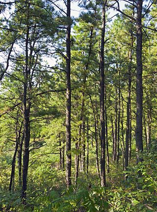
The Albany Pine Bush, referred to locally as the Pine Bush, is one of the largest inland pine barrens in the world. It is centrally located in New York's Capital District within Albany and Schenectady counties, between the cities of Albany and Schenectady. The Albany Pine Bush was formed thousands of years ago, following the drainage of Glacial Lake Albany.

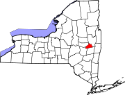
Area codes 518 and 838 are telephone area codes in the North American Numbering Plan for eastern Upstate New York in the United States. 518 is one of the 86 original North American area codes created in 1947. Area code 838 was added to the 518 numbering plan area in 2017. The two area codes serve 24 counties and 1,200 ZIP Code areas in a numbering plan area (NPA) that extends from the eastern Mohawk Valley to the Vermont border, and from the Canada–US border to south of Albany. The bulk of the population is in the Capital District, the vicinity of the cities Albany, Schenectady, and Troy. Other cities in the NPA are Glens Falls, Plattsburgh, and Saratoga Springs. It includes the Upper Hudson Valley counties, Greene and Columbia counties, and some northern parts of Dutchess County.
Rome Sand Plains is a 15,000-acre (61 km2) pine barrens about five miles (8.0 km) west of the city center of Rome in Oneida County in central New York. It consists of a mosaic of sand dunes rising about 50 feet (15 m) above low peat bogs that lie between the dunes. The barrens are covered with mixed northern hardwood forests, meadows, and wetlands. About 4,000 acres (16 km2) are protected in conservation preserves. Pine barrens are typical of seacoasts; the Rome Sand Plains is one of only a handful of inland pine barrens remaining in the United States. A second inland pine barrens, the Albany Pine Bush, is also found in New York, located north and west of state's capital Albany.

Rensselaer Lake is an artificial lake in Albany, New York, United States named for Major-General Stephen Van Rensselaer, last patroon of Rensselaerswyck. The lake was Albany's first municipally-owned source of water. It is part of a 57-acre (23 ha) park and the state's Albany Pine Bush Preserve. The lake and park have been under the purview of the Albany Water Authority since 2003.

Sandy Island Beach State Park is a New York State park on the eastern shore of Lake Ontario. Its highlight is a 1,500-foot (460 m) natural sandy beach. The park is near the southern end of a notable 17-mile (27 km) length of sandy shoreline, coastal dunes, and wetlands ; a 1959 study noted that "The eastern end of Lake Ontario contains not only the finest beaches on the entire lake but also the finest wildlife habitat."

The New York State Department of Environmental Conservation is a department of New York state government. The department guides and regulates the conservation, improvement, and protection of New York's natural resources; manages Forest Preserve lands in the Adirondack and Catskill parks, state forest lands, and wildlife management areas; regulates sport fishing, hunting and trapping; and enforces the state's environmental laws and regulations. Its regulations are compiled in Title 6 of the New York Codes, Rules and Regulations. It was founded in 1970, replacing the Conservation Department, and is headed by Basil Seggos.

The neighborhoods of Albany, New York are listed below.
Don Rittner is an American historian, archeologist, anthropologist, environmental activist, educator, author and film maker living in the Capital District, Schenectady County, New York. He is the former Schenectady County Historian, responsible for providing guidance and support to municipal historians and serving as a conduit between the State Historian in Albany and the local historians in their counties. He is also the former Schenectady City Historian and was the Albany City Archeologist (1973–79). He is the author of more than 50+ books on history, natural history, computers, and other subjects, and has been collected by libraries worldwide.

Black Pond Wildlife Management Area is a 526-acre (213 ha) New York State Wildlife Management Area (WMA) that lies on the eastern shore of Lake Ontario, and at the northern limit of an unusual region of sandy barrier beaches and lagoons. Much of the barrier beach in Black Pond WMA has forested sand dunes that are about 60 feet (18 m) high; these are the highest sand dunes in the northeast United States excepting Cape Cod. Immediately north of the WMA is the 360-acre (150 ha) El Dorado Beach Preserve, which is a bird refuge owned by The Nature Conservancy. North of the outlet from Black Pond to Lake Ontario, the shoreline is a weathered, flat bedrock shelf that is "calcareous" instead of sandy.
Karner is a hamlet of the town of Colonie, Albany County, New York, United States. Once called Center Station, it was a stop along the New York Central Railroad (NYCRR) that became famous for being the site where the Karner Blue butterfly was first identified.
Roessleville is a hamlet in the town of Colonie, Albany County, New York, United States. It is a densely settled suburb of the city of Albany, along New York State Route 5. Roessleville was a census-designated place in the 1990 Census, but was deleted in 2000, but became a CDP again in 2020.

The W. Averell Harriman State Office Building Campus is an office park in western Albany, New York, United States that houses sixteen New York State Government office buildings. The land totals roughly 330 acres (130 ha) and over 3 million square feet of office space, and about 7,000 state employees work there. The campus was built during the 1950s and 1960s in a suburban, car-oriented style bordered by an outer ring road that cuts the campus off from the surrounding neighborhoods. The campus is flanked by Washington Avenue to the north, Western Avenue to the south, University at Albany to the west, and New York State Route 85 to the east. With its own steam generation power plant for cooling and heating the campus is mostly self-sufficient.
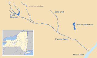
Patroon Creek is a stream in Albany County, New York, United States and is a tributary of the Hudson River which flows south to New York Harbor and the Atlantic Ocean. The creek's source is Rensselaer Lake in the western section of the city of Albany. Patroon Creek received its name from the patroon of Rensselaerswyck.
Woodlawn is a neighborhood of Schenectady, New York, United States, which occupies the entire southeastern section of that city. The neighborhood developed as a suburb of the city of Schenectady in the first two decades of the 20th century and was annexed to the city in 1923. Consisting of mostly single family detached houses it is only one of three neighborhoods in Schenectady to post an increase in population during the 1990s; Woodlawn's median population is also the oldest of Schenectady's neighborhoods.
Mont Pleasant is a neighborhood of Schenectady, New York, United States. It is located in the south central part of the city and is the most populated of Schenectady's neighborhoods and has the most housing units as well.
Bellevue is a neighborhood in Schenectady, New York, United States. Within Bellevue is the General Electric (GE) Main Plant, built in 1886 and which was once home to the company headquarters from its formation in the late-19th century until moving to Connecticut in the mid-1970s. Historically many residents walked to work to the GE plant. Bellevue, along with neighboring Mont Pleasant, was annexed by the city of Schenectady in 1903 from the town of Rotterdam.

Downtown Schenectady is the central business district for the city of Schenectady, New York. It originated in the 1820s with the moving of the commercial and industrial interests east from the original 17th and 18th century settlement, spurred on by the development of the Erie Canal. Home to the headquarters and major manufacturing plants of two large corporations, General Electric and American Locomotive Company, Downtown Schenectady catered to tens of thousands of workers in its heyday. Typical of the post-industrial Northeastern United States and Upstate New York in particular, Downtown Schenectady saw a decline in manufacturing and population starting in the 1970s. Recent construction and renovation has caused the downtown area to become an entertainment mecca for New York's Capital District anchored by Proctor's Theatre.
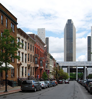
The architecture of Albany, New York, embraces a variety of architectural styles ranging from the early 18th century to the present. The city's roots date from the early 17th century and few buildings survive from that era or from the 18th and early 19th century. The completion of the Erie Canal in 1825 triggered a building boom, which continued until the Great Depression and the suburbanization of the area afterward. This accounts for much of the construction in the city's urban core along the Hudson River. Since then most construction has been largely residential, as the city spread out to its current boundaries, although there have been some large government building complexes in the modernist style, such as Empire State Plaza, which includes the Erastus Corning Tower, the tallest building in New York outside of New York City.
Pine Hills is a neighborhood in Albany, New York, generally defined as the area from Manning Boulevard to the west, Woodlawn Avenue to the south, Lake Avenue to the east, and Washington Avenue to the north. The neighborhood consists mainly of freestanding multi-unit, duplex, and semi-detached houses and is home to Albany High School, the LaSalle school, the College of St. Rose, and the Alumni Quad of the University at Albany. Though mostly residential due to historical reasons from its founding, Pine Hills is home to two neighborhood commercial districts ; Middle Madison, from Partridge to Quail streets was designated first, and then a latter designated district, Upper Madison, from Main Avenue to North Allen Street. The area of Pine Hills east of Main Avenue and north of Myrtle Avenue is commonly referred to as the student ghetto due to its predominant population of college-age students. The area of Pine Hills west of Main Avenue features many large Queen Anne, Folk Victorian, and Colonial Revival homes. Upper Madison, where it meets Western Avenue near St. Rose is the center of a commercial area, complete with a movie theater, grocery store, fast food strip mall, retail, restaurants, a library, community playhouse, police station, pharmacy, and elementary school.
Mohawk River State Park is a 105-acre (0.42 km2) undeveloped state park in the town of Niskayuna in Schenectady County, New York. The park is located adjacent to the Mohawk River.